Mori Atlas logo
National parkBanco National Park

Discover the unique protected landscape and mapped geography of this vital urban sanctuary.

Banco National Park: A Primary Tropical Forest National Park in Abidjan, Ivory Coast

Banco National Park represents one of the world's few dense primary tropical forests situated entirely within a major urban environment, located in the heart of Abidjan, Ivory Coast. This national park covers approximately 34.74 square kilometers, forming a critical ecological sanctuary amid the expanding city. Its significance extends beyond biodiversity to providing essential ecosystem services, including vital water supply and carbon sequestration for the metropolitan population, offering a unique focus for atlas-driven geographic discovery.

Urban ParkPrimary ForestTropical ForestWest AfricaIUCN Category IIWater Resource

Banco National Park

National park

Park overview

Structured park overview, official facts, and landscape profile for Banco National Park

Banco National Park park facts, protected area profile, and essential visitor context
Review the core facts for Banco National Park, including designation, size, terrain, visitor scale, habitats, and operating context in one park-focused overview.

About Banco National Park

Banco National Park represents a remarkable achievement in urban conservation, maintaining a pristine primary forest ecosystem within the boundaries of one of West Africa's largest cities. The park's square perimeter spans 7.8 kilometers on each side, enclosing 3,473.55 hectares of protected land with a boundary line measuring approximately 25.58 kilometers. This extensive green space provides essential ecological services to Abidjan's population of millions while preserving a unique pocket of tropical biodiversity. The park's hydraulic system is particularly significant, with a reservoir that captures water from the Gbangbo River and feeds 29 boreholes supplying approximately 40% of the city's drinking water. Additionally, the forest's vegetation absorbs roughly 90,000 tons of carbon dioxide each year, contributing to regional climate regulation. The park extends over former customary domains of Atié villages of Andokoi and Ebrié, as well as Anonkoua-Kouté and Agba, reflecting the area's deep historical connections to local communities. Visitors can explore the forest through maintained hiking trails and an extensive network of bike paths totaling 80 kilometers.

Quick facts and research context for Banco National Park

Banco National Park occupies a strategic position in central Abidjan, covering 3,473.55 hectares within the city limits. The park was formally established as a national park in 1953, though its protection began in 1926 when it received forest station status. It was designated as a Permanent Forest Estate of the State in 1966 under Ivorian law. The park contains a hydraulic reservoir that feeds 29 boreholes and provides approximately 40% of Abidjan's drinking water supply. This reservoir captures roughly 90,000 tons of carbon dioxide annually. The park features a river called Gbangbo, meaning refreshing water source in the local Ebrié language, and contains approximately 600 hectares of primary forest with rare tree species including mahogany and avodire. Visitors can explore hiking trails and approximately 80 kilometers of bike paths throughout the park.

Park context

Deeper park guide and search-rich context for Banco National Park

Banco National Park history, landscape, wildlife, and travel context
Explore Banco National Park through its history, landscape character, ecosystems, wildlife, conservation priorities, cultural context, and seasonal travel timing in a structured park guide built for atlas discovery and search intent.

Why Banco National Park stands out

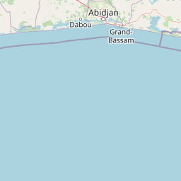
Banco National Park is most distinctive for being one of only two dense primary tropical forests located entirely within a major urban center worldwide, the other being Tijuca National Park in Rio de Janeiro. The park's extraordinary ecological significance stems from its location in the heart of Abidjan, making it a remarkable example of urban conservation where primary forest has been preserved amid city development. Beyond its biological value, the park serves as a critical infrastructure component for Abidjan, providing the majority of the city's drinking water through its hydraulic reservoir and playing a vital role in carbon sequestration. The park also contains rare tree species such as mahogany and avodire, and supports remaining populations of wildlife including chimpanzees, various primate species, antelopes, and diverse birdlife.

Banco National Park history and protected-area timeline

The protection of Banco National Park began in 1926 when the forest was granted the status of forest station, marking the initial recognition of its ecological importance. In 1953, the forest station was upgraded to become Banco National Park, formalizing its protected status at the national level. The park acquired additional legal recognition in 1966 when it was designated as a Permanent Forest Estate of the State under Law 66-433, which established regulations for the status and classification of natural reserves and national parks in Ivory Coast. A significant infrastructure development occurred in 1978 when a corridor for high-voltage power lines was opened in the northeastern part of the park at the request of the national electricity company to support Abidjan's growing energy needs. This corridor, measuring 1.7 kilometers long and 150 meters wide, created a distinctive horn-shaped feature now known as the Triangle de Sagbé, named after the nearby Abobo-Sagbé district. In 2002, Law 2002-102 further clarified the legal framework for national parks in Ivory Coast, defining national parks as areas under state control with boundaries that cannot be changed without legislative authority, designated exclusively for the propagation, protection, and conservation of vegetation and wildlife populations.

Banco National Park landscape and geographic character

The physical landscape of Banco National Park is characterized by its exceptional position as a primary tropical forest enclave within an urban setting. The park's terrain is relatively flat, typical of the coastal plain region of Ivory Coast, and is centered around the Gbangbo River, which flows through the middle of the protected area. The river's name, derived from the Ebrié language, translates to refreshing water source, reflecting the water's importance to both ecological and human communities. The park contains approximately 600 hectares of primary forest featuring rare and valuable tree species including mahogany and avodire. A hydraulic reservoir within the park serves as a critical water source for Abidjan, feeding multiple boreholes that supply the city. The park's square configuration measures 7.8 kilometers on each side, with a boundary line of 25.58 kilometers creating a clearly defined protected zone amid the surrounding urban development. The landscape includes a distinctive notch in the northeastern section created by the 1978 power line corridor, a feature that has become locally known as the Triangle de Sagbé.

Banco National Park ecosystems, habitats, and plant life

The ecological character of Banco National Park centers on its status as a rare example of intact primary tropical forest in an urban environment. The park contains approximately 600 hectares of primary forest characterized by old-growth trees including valuable species such as mahogany and avodire. This forest ecosystem provides critical habitat within the metropolitan area of Abidjan, maintaining biodiversity in a region where surrounding lands have been largely converted to urban or agricultural uses. The park's hydrological system is ecologically significant, with the Gbangbo River and associated reservoir supporting groundwater recharge that feeds 29 boreholes. The vegetation collectively captures approximately 90,000 tons of carbon dioxide annually, demonstrating the park's contribution to climate regulation and air quality maintenance for the surrounding city. The ecosystem services provided by this urban forest extend beyond biodiversity conservation to include water purification, flood regulation, and temperature moderation within the heat island effect of the growing city.

Banco National Park wildlife and species highlights

Banco National Park was historically notable for its rich biodiversity, supporting populations of various native species including the harnessed guib, a type of antelope, as well as multiple duiker species, various primates, suids including giant forest hogs and bushpigs, and a large number of bird species. However, the park's wildlife populations have faced significant pressure from surrounding urban development and human activity. Today, populations of the harnessed guib, certain monkey species, and some bird species persist within the park, though many species have declined significantly and some face extinction threats. A study conducted in 2004 and 2005 identified approximately twelve chimpanzees remaining in the park, representing a remnant population of this keystone species. The continued presence of these primates and other surviving wildlife demonstrates the park's ongoing ecological value as habitat within the urban matrix, though conservation efforts face challenges from illegal hunting, habitat fragmentation, and the impacts of surrounding urbanization.

Banco National Park conservation status and protection priorities

Banco National Park faces significant conservation challenges from its unique position within the rapidly growing city of Abidjan. The park is threatened by illegal logging and poaching activities, uncontrolled urbanization advancing from surrounding areas, and residents disposing of waste within the park boundaries. These pressures have contributed to the depletion of many wildlife species that once inhabited the forest. In response to these threats, a major conservation initiative was launched in 2022 involving the construction of a protective wall around the park perimeter. This brick curtain stands 2.5 meters high and will extend over 8 kilometers in total length when completed, designed in two phases of 4,400 meters and 4,500 meters respectively. The wall aims to shield the park from the advance of urbanization and reduce illegal access. Annual maintenance of the park requires approximately 200 million CFA francs. The park's legal protection falls under Law 2002-102, which establishes national parks as areas under state control with boundaries that cannot be altered except by legislative authority, designated for the propagation, protection, and conservation of vegetation and wildlife populations.

Banco National Park cultural meaning and human context

Banco National Park occupies land that extends over the former customary domains of Atié villages including Andokoi and Ebrié, as well as Anonkoua-Kouté and Agba, reflecting the area's historical connections to local communities. The park contains the Gbangbo River, whose name in the Ebrié language means refreshing water source, indicating the long-standing cultural significance of water resources in this landscape. A forestry school operates within the park, providing education and training in forest management and conservation. The park's establishment as a forest station in 1926 and subsequent designation as a national park in 1953 reflects Ivorian efforts to preserve forest resources in their natural state while balancing development needs in the capital city. The area also bears marks of modern infrastructure development, including the Triangle de Sagbé corridor created for electrical power lines in 1978, demonstrating the ongoing negotiation between conservation and urban development in Abidjan.

Top sights and standout views in Banco National Park

Banco National Park stands as one of the world's most significant urban protected areas, representing one of only two dense primary tropical forests located entirely within a major city. The park provides approximately 40% of Abidjan's drinking water through its hydraulic system while capturing 90,000 tons of carbon dioxide annually. Its 600 hectares of primary forest contain rare species including mahogany and avodire, and the park supports remaining populations of primates including chimpanzees. The park features 80 kilometers of bike paths and hiking trails for visitor exploration. The 2022 conservation wall project represents a major investment in protecting this urban forest from advancing development. As the second largest urban park globally, Banco National Park demonstrates the possibility of maintaining substantial ecological value within metropolitan environments.

Best time to visit Banco National Park

Banco National Park can be visited year-round given its location within Abidjan, though the best conditions typically occur during the dry seasons from November to March and from July to August. During these periods, trail conditions are generally more favorable for hiking and cycling activities, and wildlife visibility may improve as animals concentrate around water sources. The wet seasons from April to June and September to October bring heavier rainfall that can make trails muddy and less accessible, though the forest appears more lush and vibrant during these periods. The park's primary forest provides shade and relatively stable temperatures compared to the surrounding urban heat island, making any visit more comfortable. Early morning visits offer the best opportunities for wildlife observation when animals are most active, and the cooler temperatures make outdoor activity more pleasant in the tropical climate.

Park location guide

Geography guide, regional context, and park location map for Banco National Park

Banco National Park park geography, regions, and map view in Ivory Coast
Understand where Banco National Park sits in Ivory Coast through a broader geographic reading of the surrounding landscape, nearby location context, and its mapped position within the national park landscape.

How Banco National Park fits into Ivory Coast

Ivory Coast, officially the Republic of Côte d'Ivoire, is a West African country with a coastline on the Gulf of Guinea. It gained independence from France in 1960 and is now a presidential republic. The country is a major producer of cocoa and coffee, with Abidjan serving as its largest city and economic hub, while Yamoussoukro is the official capital.

Wider geography shaping Banco National Park in Ivory Coast

Ivory Coast is situated on the southern coast of West Africa along the Gulf of Guinea. It borders Guinea to the northwest, Liberia to the west, Mali to the northwest, Burkina Faso to the northeast, Ghana to the east, and the Atlantic Ocean to the south. The terrain includes coastal plains, interior highlands, and forested regions.

Map view of Banco National Park

Use this park location map to pinpoint Banco National Park in Ivory Coast, understand its exact geographic position, and read its mapped placement within the surrounding landscape more clearly.

Pigeon | © OpenStreetMap contributors
Park atlas

Uncover the regional context of protected areas and compare the geographic spread of diverse conservation landscapes.

Explore Nearby National Parks and Protected Areas: Expanding Your Discovery from Banco National Park
Expand your park discovery from Banco National Park to browse other national parks and protected areas, exploring diverse conservation landscapes and their geographic spread. Compare their unique ecological features, mapped terrain, and regional context to gain a deeper atlas understanding of protected area distribution and conservation efforts.
National parkWestern North Region

Bia National Park: Ghana's Vital Protected Forest Landscape with West Africa's Tallest Trees

Explore the unique mapped geography and biodiversity of this key conservation area.

Bia National Park serves as a crucial protected landscape in Ghana's Western North Region, celebrated for harboring some of West Africa's tallest trees and a rich diversity of wildlife. This detailed entry provides context on its mapped boundaries and ecological significance as one of the last relatively untouched forest remnants in the region. Understand the park's place within Ghana's geography and its value for conservation research, showcasing its unique transitional forest ecosystem and the documented species it protects.

Area
563 km²
Established
1974
IUCN
II
Climate
Tropical
National parkGhana

Nini-Suhien National Park: Ghana's Coastal Forest Protected Landscape and Avian Sanctuary

Explore mapped boundaries of vital tropical forest habitat.

Nini-Suhien National Park in Ghana is recognized for its protected coastal forest, a habitat type critically endangered across West Africa. Established in 1976, this national park spans 160 square kilometers, serving as a key component of the Ankasa Conservation Area and a vital corridor for wildlife. Its designation as an Important Bird Area highlights its global importance for birdlife, offering a unique geographic and ecological study within the nation's atlas of protected lands.

Area
160 km²
Established
1976
IUCN
II
Relief
Lowland
National parkIvory Coast

Taï National Park: A Primary Rainforest Protected Area in Ivory Coast

Explore mapped boundaries and critical primate habitats in West Africa.

Taï National Park in Ivory Coast stands as a monumental protected landscape, comprising the largest contiguous area of primary rainforest remaining in West Africa. Its designation as a national park highlights its critical role in preserving biodiversity and unique geographic features. Users exploring this destination can delve into its mapped terrain, understand its regional landscape context within Ivory Coast, and appreciate its significance as a vital habitat for endangered species and an integral part of the Upper Guinean forest ecosystem.

Area
3,300 km²
Established
1972
IUCN
II
National parkGhana

Bui National Park: Protected Savanna Landscape and Black Volta River Geography in Ghana

Explore the mapped boundaries and unique ecosystems of this national park.

Bui National Park, a protected national park in Ghana, offers a rich geographic discovery of savanna ecosystems bisected by the Black Volta River. Its vast mapped area provides a unique setting for understanding riparian corridors, woodland savanna, and mountainous terrain. The park is critically important for its significant hippopotamus population and its designation as an Important Bird Area, showcasing its ecological value. Exploration of Bui National Park provides insight into Ghana's protected landscapes and their strategic position within West African geography, serving as a key entity for any natural atlas.

Area
1,820 km²
Established
1971
IUCN
II
National parkIvory Coast

Comoé National Park: A UNESCO World Heritage Site and Ivory Coast's Largest National Park

Explore its diverse savanna ecosystems and gallery forest geography.

Comoé National Park is a landmark protected area in West Africa, celebrated as the most biodiverse savanna on Earth. Situated across northeastern Ivory Coast, it encompasses a unique geographic gradient from Guinea savanna to Sudanian zones, supporting varied habitats from expansive savannas to dense gallery forests along the Comoé River. Its status as a national park highlights its critical role in wildlife conservation and its significant contribution to the understanding of transitional ecological landscapes.

Area
11,500 km²
Established
1983
IUCN
II
National parkBono East Region

Digya National Park: Ghana's Oldest National Park, Bordering Lake Volta

Explore its unique geography and mapped protected boundaries.

Digya National Park is a significant protected area in Ghana, renowned as the nation's oldest, established in 1900 and gazetted as a national park in 1971. Occupying 3,743 square kilometers in the Bono East Region, it is distinctively bordered on three sides by the vast Lake Volta, creating an unparalleled terrestrial-aquatic habitat interface. This national park represents a key point in Ghana's geographic atlas, situated in a transitional zone between forest and savanna ecosystems, and is a vital hub for wildlife conservation and the study of its unique landscape character.

Area
3,743 km²
Established
1971
IUCN
II
National parkSavannah Region

Mole National Park: A Premier Protected Landscape in Ghana's Savannah Region

Explore mapped boundaries and Guinea savannah ecosystems.

Mole National Park represents a significant protected landscape within Ghana's Savannah Region, serving as the country's largest national park and a crucial conservation area for West African wildlife. The park's geography is defined by extensive Guinea savannah, characterized by grasslands with scattered woodlands and a prominent escarpment along its southern edge. Its vast expanse offers a unique opportunity to study mapped park boundaries and understand the ecosystem's role in regional conservation efforts. Discover the unique landscape context and protected area identity of this major West African wildlife refuge.

Area
4,840 km²
Established
1958
IUCN
II
Protected areaNimba County

Gibi National Forest: Protected Tropical Forest in Nimba County, Liberia

Mapped landscape and regional geography of this key conservation area.

Gibi National Forest, a protected tropical forest spanning 607 square kilometers in Nimba County, Liberia, plays a crucial role in the preservation of the Upper Guinea forest ecosystem. Established in 1960, its landscape features tropical forest terrain near the mountainous Nimba Range. This protected area contributes significantly to regional conservation strategies, offering a vital habitat within a biodiversity hotspot that faces considerable pressure.

Area
607 km²
Established
1960
IUCN
VI
Climate
Tropical

Common questions about visiting, size, designation, and location context for Banco National Park

Banco National Park FAQs for park facts, access, geography, and protected area context
Find quick answers about Banco National Park, including protected-area facts, park geography, trail and visitor context, and how the park fits into its surrounding country and regional landscape.
MoriAtlas Explorer

Continue Your Protected Areas Search Across the Global Atlas

Deepen your exploration by continuing the structured search for national parks and protected areas worldwide. Utilize the comprehensive filtering capabilities to compare different conservation landscapes and refine your understanding of global park geography. Discover more about the distribution and characteristics of protected natural areas.

Global natural geography