Mori Atlas logo
National parkMole National Park

Discover the mapped geography and savanna ecosystem of West Africa's largest wildlife refuge.

Mole National Park: Ghana's Premier National Park and Protected Landscape in the Savannah Region

Mole National Park stands as Ghana's largest and most significant protected area, covering a vast expanse of Guinea savannah in the northern Savannah Region. This national park is a vital conservation space, safeguarding expansive grasslands and woodlands that support exceptional biodiversity. Users can explore its mapped boundaries, understand its distinct landscape character defined by rolling plains and a notable escarpment, and situate it within the broader geographic context of West African protected areas.

Savannah EcosystemElephant HabitatBird Conservation AreaWest Africa Protected AreaLarge Mammal RefugeGuinea Savanna

Mole National Park

National park

Park overview

Structured park overview, official facts, and landscape profile for Mole National Park

Mole National Park park facts, protected area profile, and essential visitor context

Review the core facts for Mole National Park, including designation, size, terrain, visitor scale, habitats, and operating context in one park-focused overview.

About Mole National Park

Mole National Park represents Ghana's premier protected wilderness area and the largest wildlife refuge in the country, encompassing nearly 4,840 square kilometers of Guinea savannah in the northern Savannah Region. The park's landscape is characterized by extensive grassland plains dotted with scattered trees and woodland patches, bisected by the ephemeral Levi and Mole Rivers that become isolated watering holes during the dry season. A prominent escarpment forms the dramatic southern boundary of the park, creating varied topography that supports diverse habitats. The Guinea savannah ecosystem here represents one of West Africa's most extensive remaining tracts of relatively undisturbed grassland, supporting a remarkable concentration of large mammals despite the park's proximity to populated agricultural areas. The park is situated approximately 700 kilometers north of Accra and 430 kilometers from Kumasi, making it a significant journey for visitors but one that rewards them with an authentic safari experience in Ghana. Visitor infrastructure includes the luxury Mole Motel, making this the most developed of Ghana's national parks for tourism, though the majority of visitors are Ghanaian students who often make day trips rather than extended stays.

Quick facts and research context for Mole National Park

Mole National Park spans roughly 4,840 square kilometers of Guinea savannah in northern Ghana, established as a wildlife refuge in 1958 and redesignated as a national park in 1971. The park sits at a low elevation of approximately 50 meters above sea level, with a prominent escarpment marking its southern boundary. The Levi and Mole Rivers flow through the park as ephemeral watercourses, reducing to drinking holes during the long dry season. The park is home to over 93 mammal species and 344 recorded bird species, and has been designated an Important Bird Area by BirdLife International. It is Ghana's most developed tourism destination with the region's first luxury safari lodge.

Protection and recognition

Exploring the terrestrial conservation status and 1971 designation history of the park.

Documented Protection Status and Legal Designation of Mole National Park

Official records outline the terrestrial protection status and management scope of Mole National Park since its formal establishment in 1971. Natural area explorers can analyze documented designation parameters and historical conservation frameworks to understand the park's geographic preservation profile.

Protection details

Protection scope
Terrestrial
Designated year
1971
Transboundary protection
No
Park context

Deeper park guide and search-rich context for Mole National Park

Mole National Park history, landscape, wildlife, and travel context

Explore Mole National Park through its history, landscape character, ecosystems, wildlife, conservation priorities, cultural context, and seasonal travel timing in a structured park guide built for atlas discovery and search intent.

Why Mole National Park stands out

Mole National Park is best known for its substantial elephant population and exceptional antelope diversity. The park serves as a primary African preserve for species including kob, defassa waterbuck, roan antelope, hartebeest, oribi, bushbuck, and two duiker species. The resident elephant population of approximately 800 individuals has been the subject of significant long-term ecological studies examining their impact on savannah tree species. The park also holds the distinction of being Ghana's most developed tourism site, featuring West Africa's first luxury safari lodge, making it a premier destination for wildlife observation in the region.

Mole National Park history and protected-area timeline

The lands that comprise Mole National Park were set aside as a wildlife refuge in 1958, establishing one of Ghana's earliest protected areas focused on savannah wildlife conservation. In 1971, the small human population remaining within the park boundaries was relocated, and the designation was upgraded to full national park status, providing stronger legal protection for the area's wildlife and ecosystems. Since the resettlement of human populations, the park has become an important scientific research site, allowing researchers to conduct long-term ecological studies in a relatively undisturbed savannah environment compared to more densely populated regions of equatorial West Africa. One significant study examined the resident elephant population's impact on large trees, revealing that elephants cause greater damage to economically important species like Burkea africana and the shea tree (Vitellaria paradoxa) which provides shea butter for local communities. More recently, the area has gained recognition for a fair-trade honey initiative where nearby villagers harvest honey from the Molé National Forest using traditional, non-invasive methods, partnering with international distributors to bring the product to global markets. Despite its protected status, the park faces ongoing challenges related to poaching and inadequate funding for conservation management.

Mole National Park landscape and geographic character

The landscape of Mole National Park is defined by its position within the Guinea savannah biome, featuring rolling grassland plains with scattered woodland patches and riparian corridors along the ephemeral river systems. The most distinctive topographic feature is the sharp escarpment that forms the park's southern boundary, creating a dramatic transition between the higher plateau and the lower savannah plains below. The Levi and Mole Rivers traverse the park from north to south, but being ephemeral, they reduce to isolated pools and drinking holes during the extended dry season, creating vital water sources that concentrate wildlife during the drier months. The savannah landscape supports a mix of tall grasses including Andropogon species and various other grass types, interspersed with deciduous trees and shrubs that create the iconic park-like scenery of African savannah. The relatively flat to gently rolling terrain allows for excellent wildlife viewing opportunities across the park's vast expanse.

Mole National Park ecosystems, habitats, and plant life

Mole National Park protects one of the most extensive remaining examples of Guinea savannah ecosystem in West Africa, a habitat type characterized by a mixture of grassland and woodland that supports exceptional biodiversity. The savanna and riparian ecosystems within the park create a mosaic of habitats ranging from open grasslands to denser woodland patches along watercourses. Tree species in the park include Burkea africana, Isoberlinia doka, and Terminalia macroptera, with numerous other species including the iconic baobab (Adansonia digitata), African mahogany (Pterocarpus erinaceus), and the economically important shea tree (Vitellaria paradoxa). The savanna grass communities, while somewhat low in diversity, include several notable species and support the large herbivore populations that define the park. The riparian zones along the seasonal rivers provide critical habitat for different species and serve as wildlife corridors through the broader savannah landscape.

Mole National Park wildlife and species highlights

Mole National Park is home to over 93 mammal species and supports one of the most significant large mammal communities in Ghana. The park is particularly known for its elephant population of approximately 800 individuals, which have been the subject of detailed ecological research. Antelope species are exceptionally well represented, with the park considered a primary African preserve for kob, defassa waterbuck, roan antelope, hartebeest, oribi, bushbuck, and two duiker species including the red duiker and yellow-backed duiker. Other large mammals include hippos, African buffalo, and warthogs, while primates such as olive baboons, black-and-white colobus monkeys, green vervet monkeys, and patas monkeys are commonly observed. The park supports 33 reptile species including slender-snouted and dwarf crocodiles, while large predators like lions, leopards, and hyenas are present though sightings are uncommon. The bird fauna is equally impressive with 344 species recorded, including the martial eagle, white-headed vulture, palm-nut vulture, saddle-billed storks, herons, egrets, and the colorful violet turaco, earning the park its Important Bird Area designation.

Mole National Park conservation status and protection priorities

Mole National Park represents Ghana's most important conservation area and serves as a critical refuge for West African savannah wildlife in a region where habitat loss and human pressure increasingly threaten natural ecosystems. The park's designation as an Important Bird Area by BirdLife International recognizes its significance for maintaining significant populations of numerous bird species. However, the park faces significant conservation challenges including inadequate funding for anti-poaching efforts and management capacity. Poaching remains a concern, with poachers typically living within 50 kilometers of the park boundaries and wildlife populations on park edges experiencing greater hunting pressure than interior areas. The relocation of human populations from within the park in 1961 helped reduce internal hunting pressure but external threats persist. Despite these challenges, the protection of resident antelope species has improved since the park's initial establishment, and the park continues to serve as a vital scientific research site for understanding savannah ecosystem dynamics in a region where such relatively undisturbed areas are increasingly rare.

Mole National Park cultural meaning and human context

The area surrounding Mole National Park is home to communities whose traditional livelihoods are closely tied to the savannah environment. The nearby town of Larabanga serves as the gateway to the park and features the historic Lararabanga Mosque, an important Islamic heritage site that predates the modern park. Local communities have historically engaged with the savannah landscape through agriculture, pastoralism, and the collection of forest products including the shea nuts that provide income for women across the region. The recent fair-trade honey initiative represents an innovative approach to linking conservation with sustainable livelihoods, as local villagers harvest honey from the Molé National Forest using traditional methods and partner with international companies to access global markets. This program, co-founded by Ashanti Chief Nana Kwasi Agyemang, demonstrates how conservation areas can support sustainable community development while reducing pressure on wildlife resources.

Top sights and standout views in Mole National Park

Mole National Park offers visitors the opportunity to encounter West Africa's most impressive savannah wildlife in Ghana's largest and most developed protected area. The park's substantial elephant population provides exceptional elephant-watching opportunities, while the diversity of antelope species creates remarkable viewing prospects for species rarely seen in other West African parks. The landscape of the park, with its dramatic escarpment and expansive savannah, provides a classic African safari backdrop. The presence of West Africa's first luxury safari lodge ensures comfortable accommodation for visitors seeking an extended wildlife experience. The park's status as an Important Bird Area, combined with over 340 recorded bird species, makes it a rewarding destination for birdwatchers. The combination of significant wildlife populations, accessible infrastructure, and the dramatic savannah scenery makes Mole National Park the premier safari destination in Ghana.

Best time to visit Mole National Park

The best time to visit Mole National Park is during the dry season from November to April, when the landscape is characterized by open savannah with shorter grass that makes wildlife easier to spot. During this period, animals concentrate around the remaining water sources, improving viewing opportunities. The dry season also offers more comfortable temperatures and easier road conditions within the park. The wet season from May to October transforms the landscape with lush green vegetation and flowing rivers, but thicker vegetation can make wildlife more difficult to observe and some roads may become impassable. Birdwatching is particularly rewarding during the wet season when migratory species are present, though the dry season remains generally preferred for overall wildlife viewing. Visitors should note that the park receives relatively few international visitors compared to East African destinations, with the majority of guests being Ghanaian students.
Monthly climate preview

Long term monthly temperature and precipitation data from the Savannah Region

Climate Normals and Monthly Weather Patterns for Mole National Park

Long term average measurements show a hot dry phase peaking in March and April with maximum temperatures exceeding 41 degrees Celsius, followed by a cooler wet period from June through October. Analyzing the complete monthly climate profile reveals the precise transition between the high heat and precipitation levels of the Savannah Region.
Annual mean28 °C
26 °C31 °C
Jan26°
Feb29°
Mar31°
Apr30°
May29°
Jun28°
Jul26°
Aug26°
Sep26°
Oct27°
Nov27°
Dec26°
Warmest month
March

30.8 °C

Coolest month
August

25.9 °C

Wettest month
September

5.8 mm/day

Driest month
December

0.1 mm/day

Park location guide

Geography guide, regional context, and park location map for Mole National Park

Mole National Park park geography, regions, and map view in Ghana

Understand where Mole National Park sits in Ghana through a broader geographic reading of the surrounding landscape, nearby location context, and its mapped position within the national park landscape.

How Mole National Park fits into Ghana

Ghana, officially the Republic of Ghana, is a West African nation spanning approximately 240,000 km² along the Gulf of Guinea. It achieved independence from Britain in 1957, becoming the first Sub-Saharan colony to do so, and transitioned to a republic in 1960. The country has a population of over 35 million, with Accra as its capital and largest city. Ghana features diverse ecosystems from coastal savannas to tropical rainforests and is linguistically and ethnically rich, with English as the official language.

Wider geography shaping Mole National Park in Ghana

Ghana is located in West Africa along the Gulf of Guinea and Atlantic Ocean to its south. It borders Côte d'Ivoire to the west, Burkina Faso to the north, and Togo to the east. The country spans diverse ecologies including coastal savannas and tropical rainforests.

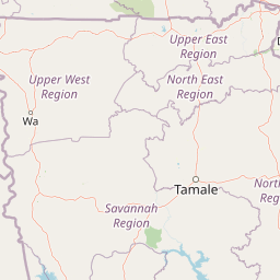
Map view of Mole National Park

Use this park location map to pinpoint Mole National Park in Ghana, understand its exact geographic position, and read its mapped placement within the surrounding landscape more clearly.

Pigeon | © OpenStreetMap contributors

Location context for Mole National Park

Savannah Region
Park atlas

Explore the Surrounding Savannah Ecosystems and Other Protected Landscapes in Ghana and West Africa

Discover More National Parks and Protected Areas Near Mole National Park

After exploring Mole National Park, browse other national parks and protected areas across Ghana and the wider West African region, revealing diverse savannah ecosystems and significant wildlife habitats. Compare protected landscapes, trace regional conservation efforts, and map the geographic spread of natural refuges that connect to Mole National Park's unique environment.
Wildlife reserveUpper West Region
About 67 km away#1 closest

West

Wechiau Community Hippo Sanctuary: Protected River Landscapes and Savanna Wildlife Reserve

Upper West Region, Ghana: Riverine ecology and community-managed boundaries

Wechiau Community Hippo Sanctuary encompasses a protected stretch of the Black Volta, providing essential habitat for hippopotamuses in northwestern Ghana. This wildlife reserve features a diverse landscape of riverine forests, sandbanks, and savanna trails. The sanctuary demonstrates how local traditional governance maintains critical natural terrain while fostering an integrated cultural and ecological landscape.

Established
1999
Relief
Lowland
Scope
Terrestrial
Water
Major water bodies
Wildlife reserveUpper West Region
About 80 km away#2 closest

Northwest

Gbele Resource Centre Wildlife Reserve: A Regional Atlas of Protected Savanna Landscapes

Mapped geography and protected woodland in Ghana

Gbele Resource Centre represents one of the most substantial protected savanna landscapes in northwestern Ghana, spanning over 500 square kilometres of Sudano-Sahelian woodland. The terrain is defined by the seasonal Kulpawn River and a distinct composition of African baobab and sycamore fig trees, which together anchor an important ecological corridor. This reserve provides a vital opportunity to map and understand the conservation geography and avian diversity that distinguish the Upper West Region from other parts of the country.

Area
565 km²
Relief
Lowland
Scope
Terrestrial
Water
Minor water
Watercolor illustration of a landscape with green fields, trees, and a body of water
National parkIvory Coast
90 km away#3 closest

West

Comoé National Park: Geographic and Environmental Overview of the Ivory Coast Reserve

Mapping the transitions of West Africa's largest protected savanna ecosystem.

Comoé National Park serves as an ecological crossroads in north-eastern Ivory Coast, protecting 11,500 square kilometers of diverse terrain. The park hosts an extraordinary gradient of habitats, from dense gallery forests hugging the 230 kilometer stretch of the Comoé River to open, dry Sudanian savannas. Its geological foundation, featuring dramatic granite inselbergs and wide plains, supports a highly complex network of life, making it a cornerstone for understanding West African regional conservation and landscape ecology.

Area
11,500 km²
Established
1983
IUCN
II
Relief
Lowland
National parkIvory Coast
90 km away#4 closest

West

Comoé National Park: Geographic Overview and Protected Landscape Analysis

Mapping the savanna and river corridors of Ivory Coast

Comoé National Park spans the northeastern reaches of Ivory Coast, providing a crucial protected space for West Sudanian savanna and gallery forests. This large-scale reserve is characterized by the hydrological influence of the Comoé River, which carves through the undulating plains to create seasonal floodplains and dense riverine corridors that serve as essential habitat for regional wildlife populations.

Area
11,491.5 km²
Established
1968
IUCN
II
Relief
Upland
National parkGhana
About 102 km away#5 closest

South

Bui National Park: Protected Savanna Landscape and Black Volta River Geography in Ghana

Explore the mapped boundaries and unique ecosystems of this national park.

Bui National Park, a protected national park in Ghana, offers a rich geographic discovery of savanna ecosystems bisected by the Black Volta River. Its vast mapped area provides a unique setting for understanding riparian corridors, woodland savanna, and mountainous terrain. The park is critically important for its significant hippopotamus population and its designation as an Important Bird Area, showcasing its ecological value. Exploration of Bui National Park provides insight into Ghana's protected landscapes and their strategic position within West African geography, serving as a key entity for any natural atlas.

Area
1,820 km²
Established
1971
IUCN
II
Relief
Mixed relief
Watercolor depiction of a river flowing through a landscape with green trees and distant mountains under a light sky
National parkBurkina Faso
About 148 km away#6 closest

North

Kaboré Tambi National Park: Burkina Faso's Largest National Park and Protected Landscape

Explore the mapped savanna and birdwatching geography of this vital West African area.

Kaboré Tambi National Park represents a critical protected area in Burkina Faso, spanning a considerable expanse of Sudan-Guinea savanna. The park's geography is defined by the Nazinon River and a mosaic of woodland and grassland ecosystems, making it a significant site for understanding regional protected lands and landscape ecology. It offers a valuable point of reference for atlas-based exploration of West African natural areas.

Area
1,555 km²
Established
1976
IUCN
II
Relief
Lowland
Wildlife reserveBono East Region
About 167 km away#7 closest

South

Boabeng-Fiema Monkey Sanctuary: Geographic Boundaries and Wildlife Reserve Context

Community-protected forest landscapes in Ghana

Boabeng-Fiema Monkey Sanctuary represents a rare community-based wildlife reserve located in central Ghana. Spanning 4.4 square kilometers between the villages of Boabeng and Fiema, the forest provides essential habitat for primate populations protected by generations of cultural tradition. This detail page offers geographic context, map exploration of the forest reserve, and insight into the unique intersection of woodland ecosystems and community-enforced conservation in the Bono East Region.

Area
4.4 km²
Established
1970
Relief
Lowland
Climate
Tropical
Wildlife reserveBurkina Faso
About 178 km away#8 closest

Northeast

Lac de Bagré Wildlife Reserve: Mapping the Inland Reservoir of Central Burkina Faso

A critical wetland site within the Nakambé River valley.

Lac de Bagré acts as a major freshwater reservoir, stretching through the Boulgou and Zoundwéogo provinces of Burkina Faso. This artificial lake, created by the Bagré Dam, supports a unique ecological profile as a Ramsar-recognized wetland, offering a deep look into the intersection of hydrological infrastructure and protected Sahelian landscapes.

Area
367.93 km²
Established
1992
Water
Water-dominated

Common questions about visiting, size, designation, and location context for Mole National Park

Mole National Park FAQs for park facts, access, geography, and protected area context

Find quick answers about Mole National Park, including protected-area facts, park geography, trail and visitor context, and how the park fits into its surrounding country and regional landscape.
MoriAtlas Explorer

Continue Your Protected Areas Search Across the Global Atlas

Deepen your exploration by continuing the structured search for national parks and protected areas worldwide. Utilize the comprehensive filtering capabilities to compare different conservation landscapes and refine your understanding of global park geography. Discover more about the distribution and characteristics of protected natural areas.

Global natural geography