
Mori Atlas logo
National parkBafing National Park

Discover the mapped boundaries and regional geography of this vital national park on the Manding Plateau.

Bafing National Park: Protected Woodland Ecosystem and Chimpanzee Habitat in Mali

Bafing National Park represents a significant protected landscape in southern Mali, serving as a crucial habitat for chimpanzees and an Important Bird Area. This national park encompasses approximately 5,000 square kilometers of rolling woodlands and savanna terrain on the Manding Plateau, offering unique opportunities for atlas-style exploration of its protected boundaries and the surrounding West African geography.

national parkwoodland ecosystemchimpanzee habitatbird conservationimportant bird areawest africa

Bafing National Park

National park

Park overview

Structured park overview, official facts, and landscape profile for Bafing National Park

Bafing National Park park facts, protected area profile, and essential visitor context

Review the core facts for Bafing National Park, including designation, size, terrain, visitor scale, habitats, and operating context in one park-focused overview.

About Bafing National Park

Bafing National Park represents a significant conservation achievement for Mali and the broader West African region. Established in 2000, the park covers approximately 5,000 square kilometers of primarily woodland habitat on the Manding Plateau in southern Mali. As part of the Bafing Biosphere Reserve, which also includes Korofin and Wongo National Parks, the protected area contributes to a coordinated conservation approach across the region. The park's designation as an IUCN Category II national park reflects its primary purpose of protecting natural ecosystems while allowing for sustainable visitor enjoyment. The woodland environment that dominates the park provides crucial habitat for species that have limited protection elsewhere in the Manding Plateau region, making Bafing a critical refuge for regional biodiversity.

Quick facts and research context for Bafing National Park

Bafing National Park is located in southern Mali on the Manding Plateau, established in 2000 with an area of approximately 5,000 square kilometers. It is classified as an IUCN Category II protected area and forms part of the Bafing Biosphere Reserve alongside Korofin and Wongo National Parks. The park features woodlands as its dominant landscape type and serves as the sole protected area for chimpanzees in the Manding Plateau region. It has been designated an Important Bird Area due to its significant bird populations including violet turacos, Senegal parrots, and numerous other species.

Protection and recognition

Verifying the established terrestrial framework and official conservation designation history.

Bafing National Park Protected Area Designation and Terrestrial Scope

Bafing National Park features a dedicated terrestrial designation established in the year 2000 to manage its specific regional boundaries. Researchers can explore the official protection status, management scope, and verified historical records to understand how the designated terrain fits into the broader network of global conservation efforts.

Protection details

Protection scope
Terrestrial
Designated year
2000
Transboundary protection
No
Park context

Deeper park guide and search-rich context for Bafing National Park

Bafing National Park history, landscape, wildlife, and travel context

Explore Bafing National Park through its history, landscape character, ecosystems, wildlife, conservation priorities, cultural context, and seasonal travel timing in a structured park guide built for atlas discovery and search intent.

Why Bafing National Park stands out

Bafing National Park is best known for two major conservation distinctions. It is the only protected area within the Manding Plateau that provides habitat protection for chimpanzees, making it critically important for West African primate conservation. The park is also recognized as an Important Bird Area, supporting significant populations of bird species including violet turacos, blue-bellied rollers, fox kestrels, Senegal parrots, bronze-tailed starlings, and several finch species. The woodland-dominated landscape represents a relatively intact ecosystem in a region where such habitats face considerable pressure.

Bafing National Park history and protected-area timeline

Bafing National Park was officially established on July 1, 2000, representing a relatively recent addition to Mali's protected area network. The creation of the park was part of broader efforts to conserve the unique ecosystems of the Manding Plateau region, which had faced increasing environmental pressure from agricultural expansion and other human activities. The park was integrated into the Bafing Biosphere Reserve, a designation that recognizes the ecological importance of the area and coordinates conservation efforts across multiple protected components including Korofin and Wongo National Parks. The establishment of the park filled a critical gap in regional conservation by providing protected status to chimpanzee populations that had no formal habitat protection elsewhere in the Manding Plateau.

Bafing National Park landscape and geographic character

The landscape of Bafing National Park is characterized by woodlands that form the dominant vegetation type across the protected area. The Manding Plateau provides a gently rolling terrain with a mix of woodland canopies and more open savanna areas. The park's location in southern Mali places it within a climatic zone that supports more lush vegetation compared to the semi-arid northern regions of the country. The woodland ecosystem includes a variety of tree species adapted to the regional climate, creating a habitat structure that supports diverse fauna. The landscape provides both visual appeal and ecological function, with the connected woodland areas forming corridors that allow wildlife movement across the broader landscape.

Bafing National Park ecosystems, habitats, and plant life

The nature of Bafing National Park centers on its woodland ecosystems that support remarkable biodiversity in the Manding Plateau region. The park represents one of the more intact woodland habitats in southern Mali, providing essential habitat for species with limited protected ranges. The chimpanzee population represents the park's most significant conservation priority, as Bafing serves as the only protected area specifically designated for chimpanzee conservation in the Manding Plateau. Beyond primates, the park supports diverse bird communities that have earned it Important Bird Area status, with the woodland canopy and forest edges providing crucial nesting and foraging habitat for numerous species.

Bafing National Park wildlife and species highlights

Bafing National Park supports significant wildlife populations, with chimpanzees representing the flagship mammal species. The park is the only designated protected area for chimpanzees within the Manding Plateau, highlighting its critical importance for this endangered primate species. The avifauna is exceptionally diverse, with the park supporting significant populations of violet turacos, blue-bellied rollers, fox kestrels, Senegal parrots, bronze-tailed starlings, white-crowned robin-chats, and white-fronted black-chats. The park also provides habitat for Mali firefinches, black-faced firefinches, and grey-headed olivebacks, species that rely on the woodland and savanna edge habitats found within the protected area.

Bafing National Park conservation status and protection priorities

Bafing National Park holds significant conservation importance for both regional and global biodiversity. Its designation as an Important Bird Area by BirdLife International recognizes the park's role in supporting bird species of conservation concern, with several species present in significant populations. The park's critical role as the only protected area for chimpanzees in the Manding Plateau makes it essential for the survival of these populations in the region. The inclusion of Bafing within the Bafing Biosphere Reserve reflects a coordinated approach to conservation that recognizes the interconnected nature of the regional ecosystem, linking protection efforts across multiple protected areas to maintain ecological connectivity and biodiversity.

Top sights and standout views in Bafing National Park

Bafing National Park stands out as a critical conservation area in West Africa, offering the only protected habitat for chimpanzees in the Manding Plateau region while simultaneously protecting significant bird populations. The park's woodland ecosystem, part of the larger Bafing Biosphere Reserve, represents relatively intact habitat in a region where such environments face considerable pressure. The combination of primate conservation significance and Important Bird Area status makes Bafing a notable protected area that serves multiple conservation objectives simultaneously.

Monthly climate preview

Trace the shifting precipitation rhythms and extreme temperature ranges across the year

Bafing National Park Monthly Climate and Average Temperature Patterns

Long-term measurements in Bafing National Park show a transition from intense heat reaching over forty-four degrees Celsius to a concentrated mid-year rainy period. Examining the complete monthly climate profile provides the exact average temperatures and daily precipitation levels required to map these distinct annual weather cycles.
Annual mean28 °C
25 °C35 °C
Jan25°
Feb28°
Mar31°
Apr34°
May35°
Jun32°
Jul28°
Aug26°
Sep26°
Oct27°
Nov26°
Dec25°
Warmest month
May

34.5 °C

Coolest month
December

24.8 °C

Wettest month
August

8.4 mm/day

Driest month
January

0 mm/day

Park location guide

Geography guide, regional context, and park location map for Bafing National Park

Bafing National Park park geography, regions, and map view in Mali

Understand where Bafing National Park sits in Mali through a broader geographic reading of the surrounding landscape, nearby location context, and its mapped position within the national park landscape.

How Bafing National Park fits into Mali

Mali is a landlocked West African country bordered by Algeria, Niger, Mauritania, Burkina Faso, Ivory Coast, Guinea, and Senegal. It has 13 official national languages with Bambara being the most commonly spoken. The country is historically significant as the heartland of the ancient Mali Empire.

Wider geography shaping Bafing National Park in Mali

Mali is a landlocked country in West Africa. It is bordered by Algeria to the north, Niger to the east, Mauritania to the northwest, Burkina Faso and Ivory Coast to the south, and Guinea and Senegal to the west. The northern region lies within the Sahara Desert while the southern region is in the Sudanian savanna.

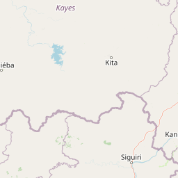
Map view of Bafing National Park

Use this park location map to pinpoint Bafing National Park in Mali, understand its exact geographic position, and read its mapped placement within the surrounding landscape more clearly.

Pigeon | © OpenStreetMap contributors
Park atlas

Trace the geographic spread of protected areas and compare their conservation focus across the Manding Plateau region.

Discover Neighboring National Parks and Protected Areas Beyond Bafing National Park in Mali

Browse a curated list of national parks and protected areas situated in proximity to Bafing National Park, highlighting other conservation landscapes across Mali and the West African region. Compare geographic extents, ecosystems, and conservation distinctions to understand the broader regional context of protected natural areas.
National parkMali
About 100 km away#1 closest

South

Wongo National Park: Discover Its Protected Landscape and Geographic Atlas Context in Mali

Explore Mali's Wongo National Park mapped boundaries and regional natural landscapes.

Wongo National Park represents a significant protected area within Mali, offering a distinct entry point for exploring national park geography and mapped landscapes. This designation within the West African region provides valuable insight into protected land distribution and the surrounding natural terrain. The park's context within the broader atlas framework allows for detailed investigation of its boundaries and its place within the country's ecological and geographic framework, supporting structured discovery.

Area
534 km²
Established
2002
IUCN
II
Climate
Temperate
National parkMali
About 115 km away#2 closest

South

Kouroufing National Park: Mali's National Park with Defined Protected Landscape Boundaries

Explore the mapped geography and protected land context of Kouroufing National Park.

Kouroufing National Park is a significant protected area recognized as a national park within Mali. This entry focuses on its distinct geographic identity and mapped boundaries, essential for understanding its role in the regional atlas. Examine the park's protected landscape context and how it contributes to the natural geography of West Africa. This resource is tailored for users seeking detailed information on specific protected areas rather than broad travel advice.

Area
557 km²
Established
2002
Scope
Terrestrial
Water
No major water
National parkSenegal
About 189 km away#3 closest

West

Niokolo-Koba National Park: Exploring Senegal's Protected Landscape Identity

Mapped boundaries and regional geography context.

Niokolo-Koba National Park offers a distinct focus on Senegal's protected landscapes, providing valuable insights for atlas and map-based exploration. This national park serves as a key geographic anchor, highlighting the natural terrain and the extent of its protected boundaries within the country. Users can delve into the specific characteristics of this area to understand its role within Senegal's diverse natural heritage and regional geography.

Area
9,130 km²
Established
1954
IUCN
II
Relief
Upland
National parkKayes Region
About 198 km away#4 closest

East

Boucle du Baoulé National Park: National Park Geographic Context and Atlas Discovery

Explore mapped boundaries and regional landscape.

Boucle du Baoulé National Park is a designated national park situated in the Kayes Region, offering a focal point for geographic exploration within Mali. This entry provides critical atlas-level details on its protected landscape, enabling users to trace its mapped boundaries and understand its position within the surrounding natural terrain. Dive into the specific geography of Boucle du Baoulé National Park to enhance your understanding of protected areas and their regional significance.

Area
25,330 km²
Established
1982
IUCN
II
Climate
Arid
National parkBoké
About 301 km away#5 closest

Southwest

Parc national du Badiar: Protected Savanna and Transboundary Geography in Boké, Guinea

Explore the mapped landscape of a major West African biodiversity stronghold

Parc national du Badiar serves as a central node in West African conservation, characterized by its open savanna plains and lush riverine forest corridors. As an established protected area, the region provides essential habitat connectivity and maintains a complex mosaic of vegetation types that define the regional geography of northern Guinea.

Area
382 km²
Established
1985
IUCN
II
Relief
Lowland
National parkGuinea
About 305 km away#6 closest

Southwest

Badiar National Park: A Transboundary Protected Landscape in Northeastern Guinea

Exploring savanna ecosystems and riverine corridors

Badiar National Park encompasses over 1,200 square kilometers of diverse West African terrain in northeastern Guinea. This protected area features a unique mosaic of open woodlands, savanna, and lush gallery forests along the Koulountou River. Serving as a transboundary ecological link, the park provides an essential habitat corridor that is critical for regional biodiversity and landscape-scale conservation planning within the West African savanna belt.

Area
1,228 km²
Established
1985
IUCN
II
Climate
Tropical
Protected areaGuinea
About 325 km away#7 closest

Southwest

Forêt classée de Nialama: Protected Landscape and Fouta Djalon Highland Geography

Exploring the forest mosaic and habitat boundaries in Guinea.

Forêt classée de Nialama represents a complex protected landscape covering 10,000 hectares of the Fouta Djalon highlands. The area features a distinct blend of gallery forest, bamboo stands, and seasonal wetlands. Known for its role in chimpanzee conservation and avian diversity, this site offers a window into the varied Sudano-Guinean terrain and highland forest ecosystems of Guinea.

Area
100 km²
Protected areaGuinea
About 337 km away#8 closest

Southeast

Sankarani River Protected Area: Guinea Highland Watershed and River Basin Geography

Mapping riparian corridors and Ramsar wetland ecosystems

The Sankarani River represents a vital hydrologic system originating in the Guinea Highlands. As a designated Ramsar site, this protected area features a unique 170-kilometre floodplain, gallery forest ribbons, and iron-bearing terrain. Map the riverine path and understand the environmental significance of this major tributary within the upper Niger Basin and the Fouta Djallon landscape.

Established
2002
Relief
Mixed relief
Scope
Terrestrial
Water
Major water bodies

Common questions about visiting, size, designation, and location context for Bafing National Park

Bafing National Park FAQs for park facts, access, geography, and protected area context

Find quick answers about Bafing National Park, including protected-area facts, park geography, trail and visitor context, and how the park fits into its surrounding country and regional landscape.
MoriAtlas Explorer

Continue Your Protected Areas Search Across the Global Atlas

Deepen your exploration by continuing the structured search for national parks and protected areas worldwide. Utilize the comprehensive filtering capabilities to compare different conservation landscapes and refine your understanding of global park geography. Discover more about the distribution and characteristics of protected natural areas.

Global natural geography
