Mori Atlas logo
National parkBudawang National Park

Discover the rugged terrain, rainforests, and geographic context of this New South Wales national park.

Budawang National Park: Protected Wilderness Landscape in New South Wales

Budawang National Park represents a significant protected wilderness area within the southern Budawang Range of New South Wales, Australia. This national park encompasses 237 square kilometers of steep, rugged terrain, characterized by deeply incised valleys, high ridgelines, and exposed rocky slopes that create a distinct mountain environment. As a wilderness area, it offers a remote experience, showcasing extensive cool temperate rainforests on its middle and upper slopes and supporting diverse habitats within its complex topography.

Wilderness AreaTemperate RainforestMountain RangeNew South WalesNative ForestAustralian Wildlife

Budawang National Park

National park

Park overview

Structured park overview, official facts, and landscape profile for Budawang National Park

Budawang National Park park facts, protected area profile, and essential visitor context
Review the core facts for Budawang National Park, including designation, size, terrain, visitor scale, habitats, and operating context in one park-focused overview.

About Budawang National Park

Budawang National Park occupies a remote and largely isolated position in southeastern New South Wales, protecting a substantial portion of the Budawang Mountain Range. The park's terrain is characterized by rugged, steep slopes and deeply incised valleys that create a dramatic and challenging landscape. Unlike many national parks in populated southeastern Australia, Budawang has retained much of its wilderness character due to its relative inaccessibility and the challenging nature of its topography. The high-elevation forests that dominate the park represent a significant conservation value, with moist forest environments persisting in the cooler upland areas. The park provides a counterpoint to the more accessible coastal and sub-alpine protected areas in the region, offering a wilderness experience rooted in rugged mountain terrain and temperate forest environments.

Quick facts and research context for Budawang National Park

Budawang National Park spans 237 square kilometres in the southern Budawang Range of New South Wales, approximately 200km southwest of Sydney. The park was established in 1977 and is classified as IUCN Category Ib wilderness area. The park is named after Mount Budawang, whose Aboriginal name 'Buddawong' reflects the area's Indigenous heritage. The terrain is characterized by steep, rugged slopes and deeply incised valleys, with high-elevation moist forests dominating the landscape. The nearest towns are Braidwood to the south and Batemans Bay to the north.

Park context

Deeper park guide and search-rich context for Budawang National Park

Budawang National Park history, landscape, wildlife, and travel context
Explore Budawang National Park through its history, landscape character, ecosystems, wildlife, conservation priorities, cultural context, and seasonal travel timing in a structured park guide built for atlas discovery and search intent.

Why Budawang National Park stands out

Budawang National Park is best known for its rugged wilderness character and the extensive cool temperate rainforests that clothe its middle and upper slopes. The park protects significant pockets of unique habitats within the southern Budawang Range, where deeply incised valleys and steep terrain have created ecological niches supporting several notable species. The area is particularly recognized for its populations of greater gliders, swamp wallabies, and potoroos, as well as bird species including green catbirds and lyrebirds. The historic use of Mount Budawang as a signal fire vantage point by Aboriginal peoples adds cultural significance to the landscape.

Rocky outcrops, eucalyptus trees, and distant mountain ranges visible from a high elevation viewpoint
View from Dithol Summit in Budawang National Park, Australia

Budawang National Park history and protected-area timeline

Budawang National Park was established on 23 September 1977 as part of New South Wales's expansion of its protected area network during the late twentieth century. The park was named following the established geographic feature of Mount Budawang, which itself derives from the Aboriginal word 'Buddawong'. This naming reflects the Indigenous heritage of the region and acknowledges the traditional connection between Aboriginal peoples and the Budawang Range landscape. Historically, the elevated vantage point provided by Mount Budawang was used for signal fires, a practice that formed part of the communication networks employed by local Aboriginal communities. The park's designation as IUCN Category Ib reflects its subsequent recognition as a wilderness area requiring the highest level of protection within the national park framework.

Budawang National Park landscape and geographic character

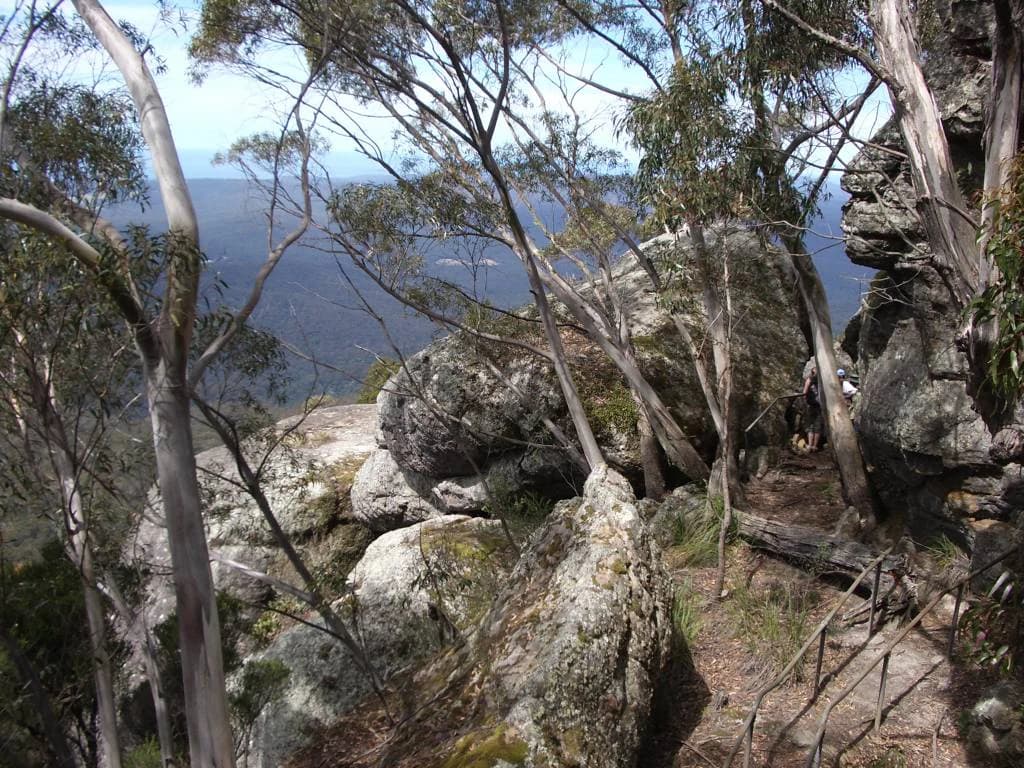
The landscape of Budawang National Park is defined by the southern extent of the Budawang Range, a mountain system characterized by its rugged and steep terrain. The range features prominent ridgelines, deeply incised valleys, and rocky outcrops that create a visually distinct mountain environment. The park's elevation ranges from lower valleys to higher ridgelines, with the terrain becoming increasingly steep and broken as elevation increases. The combination of steep slopes and the underlying geology has produced a landscape of considerable topographic complexity, with limited flat areas and numerous drainage lines cutting through the terrain. The high-elevation sections of the park support moist forest environments that contrast with the drier conditions found in the valley floors and lower slopes.

Close-up of a tree branch covered in yellow-green moss with dense forest background
Papillaria moss-covered branch in Budawang National Park's cloudforest

Budawang National Park ecosystems, habitats, and plant life

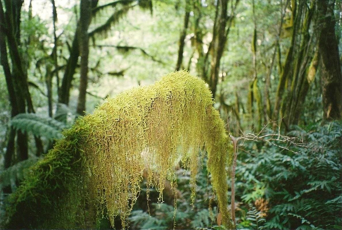
The ecological character of Budawang National Park is defined by the interaction between elevation, moisture availability, and the steep terrain of the Budawang Range. The middle and upper slopes of the park are cloaked in cool temperate rainforest, a habitat type that thrives in the moister, cooler conditions found at higher elevations. These rainforests represent a significant conservation asset, supporting species assemblages characteristic of southern Australian temperate forest environments. In contrast, the lower elevations of the park, particularly those drained by small rivers and streams, support dry rainforest vegetation dominated by trees including ironwood. This elevation-based zonation creates a mosaic of forest types within a relatively compact area, with the park's rugged terrain creating numerous microclimates and habitat pockets.

Budawang National Park wildlife and species highlights

Budawang National Park supports diverse wildlife populations that have adapted to the varied forest environments created by the park's topography and elevation range. The park is home to good populations of swamp wallabies, greater gliders, and potoroos, all of which rely on the dense forest cover and ground-layer vegetation for habitat. The open forest and woodland areas support eastern grey kangaroos, common wombats, honeyeaters, and white-throated tree creepers, representing the more commonly encountered mammal and bird species. Notably, the park provides habitat for green catbirds and lyrebirds, two bird species that are characteristic of Australian temperate forest environments and are often highlighted as indicators of forest health. The diversity of habitats created by the park's rugged terrain has enabled several plant and animal species to persist in pockets of unique habitat.

Budawang National Park conservation status and protection priorities

Budawang National Park contributes significantly to the conservation estate in southeastern New South Wales through its protection of wilderness-area lands within the Budawang Range. The park's IUCN Category Ib designation reflects its recognition as an area of outstanding universal value where natural processes are allowed to continue substantially undisturbed. The protection of the park's cool temperate rainforests and the diverse habitats created by the rugged terrain conserves ecological communities that have become increasingly rare in the more heavily cleared and developed landscapes surrounding the Budawang Range. The park's isolation and difficult terrain have historically limited development pressure, allowing natural ecosystems to persist with minimal infrastructure and human disturbance.

Budawang National Park cultural meaning and human context

The cultural context of Budawang National Park is grounded in the Aboriginal heritage of the Budawang Range region. The park is named after Mount Budawang, whose name derives from the Aboriginal word 'Buddawong', indicating the longstanding Indigenous association with this landscape. The mountain served as a historically significant vantage point where signal fires were lit, reflecting the role of elevated terrain in Aboriginal communication networks. This cultural heritage connects the protected landscape to the broader history of Aboriginal land management and spiritual connection to country in southeastern Australia. The park's establishment formally recognized this Indigenous heritage while also providing protection for the natural values of the Budawang Range.

Top sights and standout views in Budawang National Park

The defining highlights of Budawang National Park include its status as a protected wilderness area in the southern Budawang Range, the extensive cool temperate rainforests on its middle and upper slopes, and populations of notable wildlife species including greater gliders, green catbirds, and lyrebirds. The park offers a rugged, remote mountain experience distinct from the more accessible coastal and alpine protected areas of New South Wales. The cultural significance of the Aboriginal-named Mount Budawang and its historical role as a signal fire vantage point adds depth to the visitor experience. The park's diverse habitats, from dry rainforest in lower valleys to cool temperate rainforest at higher elevations, create ecological variety within a relatively compact wilderness area.

Best time to visit Budawang National Park

The cool temperate rainforest and high-elevation forest environments of Budawang National Park are most pleasant during the milder months of autumn and spring, when temperatures are moderate and forest conditions are comfortable for walking. Summer months can bring warm conditions in the lower elevations, though the forest canopy provides shade. Winter brings colder temperatures to the upland areas and can result in fog or low cloud in the valleys, though this period offers a different character for those seeking solitude. The park's rugged terrain means that conditions can change rapidly, and visitors should be prepared for the remote nature of the area. The lack of extensive visitor infrastructure contributes to the wilderness character but requires self-sufficiency from those exploring the park.

Park location guide

Geography guide, regional context, and park location map for Budawang National Park

Budawang National Park park geography, regions, and map view in Australia
Understand where Budawang National Park sits in Australia through a broader geographic reading of the surrounding landscape, nearby location context, and its mapped position within the national park landscape.

How Budawang National Park fits into Australia

Australia is a constitutional monarchy and federal parliamentary democracy comprising six states and ten territories. With a population of nearly 28 million, it is one of the world's most urbanised countries, with most people concentrated on the eastern seaboard. The country has a high Human Development Index and is known for its cultural diversity, ancient Aboriginal heritage, and unique wildlife.

Wider geography shaping Budawang National Park in Australia

Australia occupies the entire Australian continent, the island of Tasmania, and numerous smaller islands. It is the world's flattest and driest inhabited continent, featuring vast deserts in the interior (the Outback), tropical rainforests along the eastern coast, and a coastline bordering the Indian and Pacific Oceans.

Map view of Budawang National Park

Use this park location map to pinpoint Budawang National Park in Australia, understand its exact geographic position, and read its mapped placement within the surrounding landscape more clearly.

Pigeon | © OpenStreetMap contributors

Location context for Budawang National Park

New South Wales

Explore the distinctive rugged terrain, cool temperate rainforests, and diverse habitats that define the protected landscape of this Australian mountain range.

Budawang National Park Scenery: Explore Rugged Mountain Landscapes and Protected Wilderness Views
Browse a curated collection of Budawang National Park images to visually understand its distinct rugged terrain, extensive cool temperate rainforests, and unique habitat pockets within the southern Budawang Range. These photographs offer valuable insight into the park's remote wilderness character, revealing its steep valleys, high ridgelines, and the diverse protected-area environment of New South Wales.

Rocky outcrops, eucalyptus trees, and distant mountain ranges visible from a high elevation viewpoint

Distant mountain ranges with layered peaks under a partly cloudy sky, foreground of dense forest vegetation.

Close-up of a tree branch covered in yellow-green moss with dense forest background

Park atlas

Trace the mapped geography of adjacent wilderness areas and mountain ranges in New South Wales

Explore Related National Parks and Protected Areas Near Budawang National Park
After exploring Budawang National Park, discover other national parks and protected areas located in the surrounding regions of New South Wales. Compare geographic features, trace connected mountain ranges, and understand the diverse protected landscapes that define this part of southeastern Australia.
National parkNew South Wales

Bimberamala National Park: New South Wales National Park Protected Landscape Atlas

Mapped boundaries and regional geographic context for discovery.

Bimberamala National Park is a protected natural area within New South Wales, Australia, offering a distinct geographic profile. As a national park, its mapped boundaries and landscape characteristics are valuable for understanding regional protected areas and their distribution. This entity provides a focused point for atlas-based geographic exploration, allowing users to study its specific terrain and environmental context within the wider Australian geography.

Area
43.96 km²
Established
2001
IUCN
II
Relief
Upland
Watercolor illustration of green hills, pink and purple floral elements, a body of water, and a soft sky.
National parkNew South Wales

Monga National Park: New South Wales National Park Protected Area Map and Geography

Discover the landscape context and mapped boundaries of this national park.

Delve into the protected landscape of Monga National Park, a designated national park situated in New South Wales, Australia. This page offers detailed insights into its geographic positioning, mapped protected area boundaries, and its role within the regional atlas. Understand the park's natural terrain and its significance as a protected natural area, contributing to a comprehensive geographic understanding.

Area
251.44 km²
Established
2001
IUCN
II
Relief
Upland
National parkAustralia

Clyde River National Park: Australia's Protected Riverine Landscape and Swift Parrot Sanctuary

Discover its vital role in conservation and mapped geography.

Clyde River National Park is a critical protected area in Australia, safeguarding nine kilometers of river frontage along the Clyde River. Established for its ecological importance, particularly as a sanctuary for the endangered swift parrot, the park's landscape is characterized by riverine forests and eucalyptus woodlands. This designation highlights its role in preserving key habitats and contributing to the regional map of protected lands vital for biodiversity.

Area
10.91 km²
Established
2000
IUCN
II
Scope
Terrestrial
Watercolor landscape illustration showing green fields, trees, hills, and pastel sky
National parkNew South Wales

Morton National Park: A Protected Landscape of Waterfalls and Dissected Plateaus in New South Wales

Explore its mapped boundaries and regional geographic context.

Morton National Park is a nationally recognized protected area within New South Wales, Australia, celebrated for its striking natural features and geographic significance. The park's landscape is characterized by a dramatic dissected plateau, giving rise to impressive waterfall systems such as Fitzroy Falls and Belmore Falls that cascade into deep gorges. As a key component of the Southern Highlands' natural heritage, Morton National Park provides a rich subject for atlas exploration, offering insights into regional terrain, protected land distribution, and the unique interplay of natural elements within this Australian national park.

Area
1,997.45 km²
Established
1967
IUCN
II
Relief
Mixed relief
National parkNew South Wales

Meroo National Park: Protected National Park in New South Wales with Mapped Landscape Identity

Explore the protected landscape and geographic context of this national park.

Meroo National Park is a protected national park located in New South Wales, Australia, offering specific geographic context for atlas exploration. This page provides details on its mapped boundaries and its identity as a conservation landscape. Understanding Meroo National Park's place within the regional geography of New South Wales is key to appreciating its protected status and unique natural characteristics, all within a framework designed for structured geographic discovery.

Established
2001
IUCN
II
Relief
Lowland
Climate
Temperate
National parkNew South Wales

Murramarang National Park: Discover Its Mapped Protected Area and New South Wales Geography

Explore the unique landscape and geographic features.

Murramarang National Park stands as a distinct protected area within New South Wales, offering a unique landscape to explore through its mapped boundaries and regional geographic context. This resource provides essential details for understanding its place in the atlas of Australian protected lands. Users can gain a factual appreciation of the park's physical geography and its identity as a national park, grounded in spatial data and mapped terrain.

Area
121 km²
Established
1973
IUCN
II
Relief
Mountain
National parkNew South Wales

Conjola National Park: Mapped Protected Landscape within New South Wales Geography

Explore the park's protected boundaries and regional terrain.

Conjola National Park represents a distinct protected landscape within New South Wales, offering rich opportunities for geographic discovery. As a national park, its mapped boundaries and natural terrain contribute significantly to the regional atlas. This entry provides essential context for understanding the park's protected identity and its contribution to the broader geographic landscape of Australia, facilitating detailed map exploration.

Area
10 km²
Established
1994
IUCN
II
Relief
Lowland
National parkNew South Wales

Jerrawangala National Park: Protected Landscape Identity and New South Wales Geographic Context

Explore its mapped terrain and regional protected area distribution.

Jerrawangala National Park stands as a distinct protected natural area within the geography of New South Wales. This resource details its protected landscape character and its position within the broader regional atlas. Users can understand the park's mapped boundaries and its role in conservation landscapes, offering a concrete geographic anchor for exploration. Dive into the specifics of this national park's setting and its contribution to understanding the natural terrain of Australia.

Relief
Upland
Climate
Temperate
Access
Remote access
Scope
Terrestrial

Common questions about visiting, size, designation, and location context for Budawang National Park

Budawang National Park FAQs for park facts, access, geography, and protected area context
Find quick answers about Budawang National Park, including protected-area facts, park geography, trail and visitor context, and how the park fits into its surrounding country and regional landscape.
MoriAtlas Explorer

Continue Your Protected Areas Search Across the Global Atlas

Deepen your exploration by continuing the structured search for national parks and protected areas worldwide. Utilize the comprehensive filtering capabilities to compare different conservation landscapes and refine your understanding of global park geography. Discover more about the distribution and characteristics of protected natural areas.

Global natural geography