Mori Atlas logo
National parkMorton National Park

Discover the mapped boundaries and dramatic terrain of this significant national park.

Morton National Park: Protected Landscape, Waterfalls, and Regional Geography in New South Wales

Morton National Park, a vast protected national park located in New South Wales, Australia, offers a remarkable atlas exploration of its unique dissected plateau landscape. This significant protected area is defined by dramatic gorges, spectacular waterfall systems like Fitzroy Falls and Belmore Falls, and its role within the broader geography of the Southern Highlands and South Coast regions. Engage with the mapped park boundaries and understand the natural terrain that makes Morton National Park a key destination for geographic discovery.

WaterfallsGorgesAboriginal cultural heritageRainforestPlateau landscapeNature reserve
Illustration of a waterfall flowing into a pool surrounded by rocky cliffs and green ferns

Morton National Park

National park

Park overview

Structured park overview, official facts, and landscape profile for Morton National Park

Morton National Park park facts, protected area profile, and essential visitor context
Review the core facts for Morton National Park, including designation, size, terrain, visitor scale, habitats, and operating context in one park-focused overview.

About Morton National Park

Morton National Park represents one of the most significant protected areas in southeastern Australia, encompassing a diverse landscape of gorges, plateaus, and waterfall systems. The park lies within the Southern Highlands, South Coast, and Illawarra regions of New South Wales, spanning an area of approximately 199,745 hectares. The terrain is characterised by a generally flat plateau surface that has been deeply dissected by erosive forces, creating steep gorge systems that channel water toward the Shoalhaven River system. The park's boundaries extend from Bundanoon in the north to areas west of Ulladulla in the south, incorporating portions of the Budawang Range. The most notable visitor attractions include Fitzroy Falls and Belmore Falls, both of which drop from the sandstone plateau edge into wet rainforest gullies below. The park is managed by the NSW National Parks and Wildlife Service and maintains its protected status as an IUCN Category II national park.

Quick facts and research context for Morton National Park

Morton National Park covers approximately 199,745 hectares of terrestrial protected area in southeastern New South Wales. The park was officially established in 1967, though it was first opened to the public in 1938. It is classified as an IUCN Category II protected area and is managed by the NSW National Parks and Wildlife Service. The park's highest point is Mount Tianjara at 768 metres above sea level. Key geographical features include the Budawang Range, steep gorge systems, and the Shoalhaven River system. The park shares its southern boundary with Budawang National Park.

Park context

Deeper park guide and search-rich context for Morton National Park

Morton National Park history, landscape, wildlife, and travel context
Explore Morton National Park through its history, landscape character, ecosystems, wildlife, conservation priorities, cultural context, and seasonal travel timing in a structured park guide built for atlas discovery and search intent.

Why Morton National Park stands out

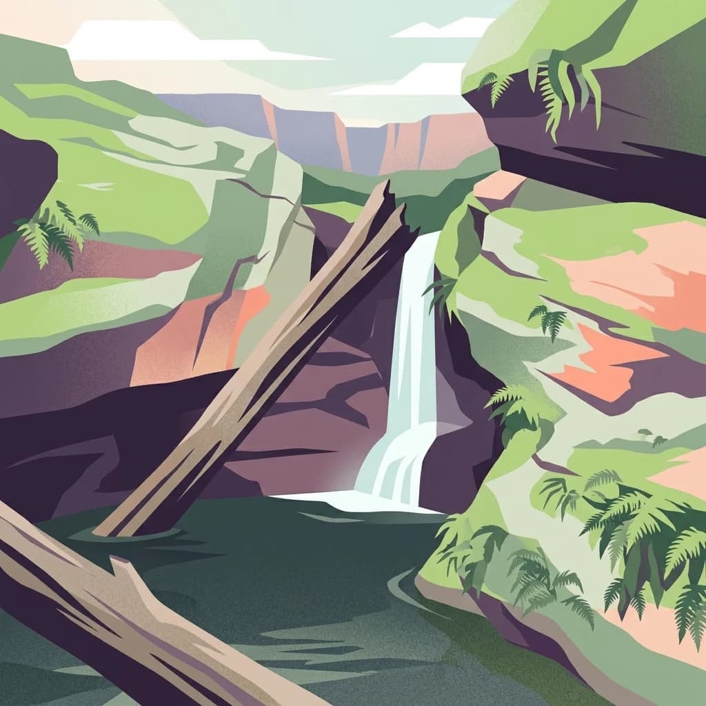
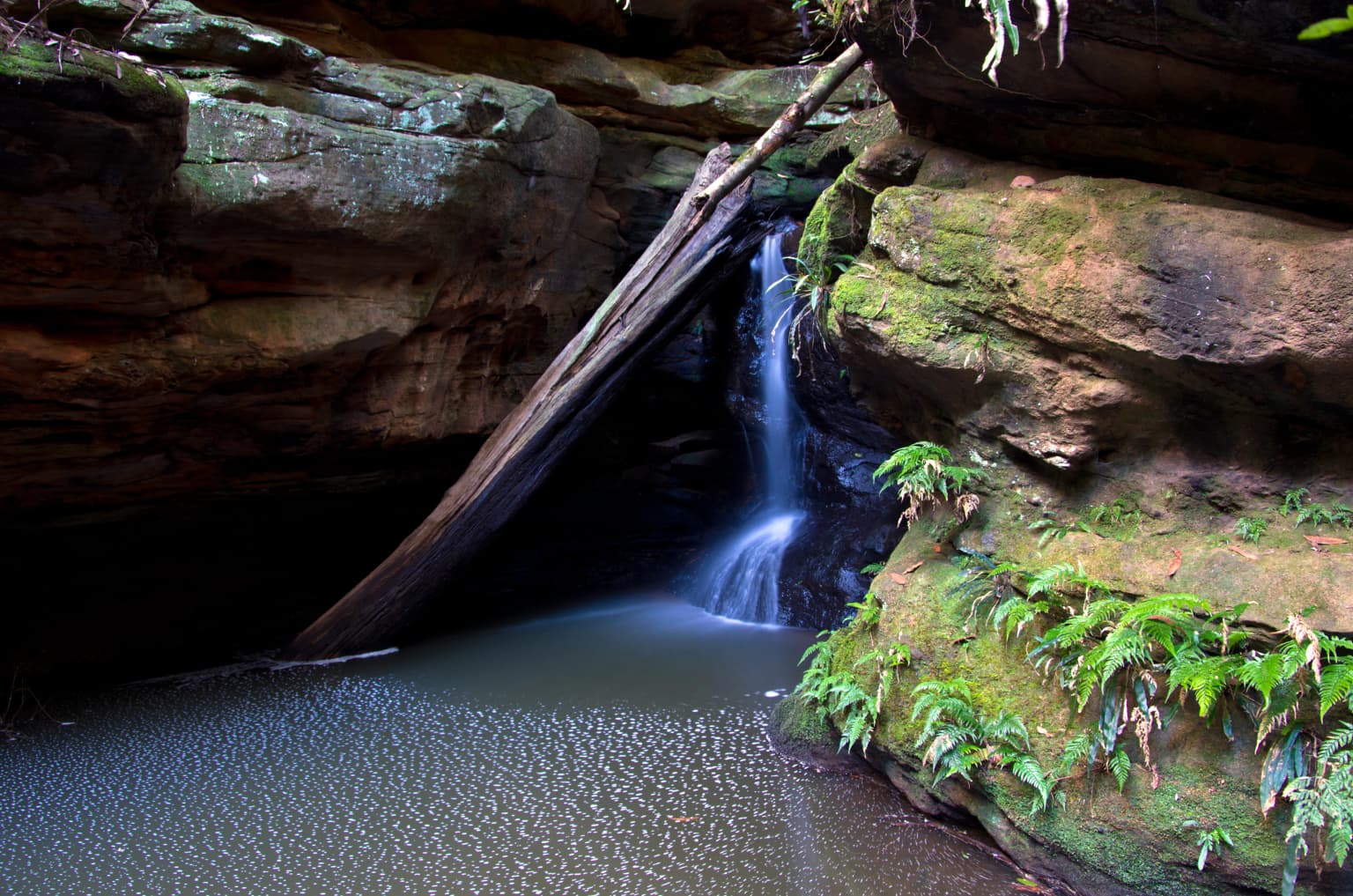
Morton National Park is best known for its spectacular waterfall system, particularly Fitzroy Falls and Belmore Falls, which are among the most visited natural attractions in the Southern Highlands region. The park is also distinguished by Pigeon House Mountain, also known as Didthul in the local Aboriginal language, which holds sacred significance in Yuin mythology. The combination of dramatic cliff-edge waterfalls, ancient Aboriginal cultural heritage, and the rugged dissected plateau landscape makes this park a standout destination for both natural beauty and cultural history in New South Wales.

Waterfall flowing over rocky cliffs into a calm pool, surrounded by mossy rocks and green ferns
Waterfall cascading into a pool surrounded by moss-covered rocks and ferns at Glow Worm Glen

Morton National Park history and protected-area timeline

Morton National Park was first opened to the public in 1938, making it one of the older national parks in New South Wales. The park was named after Mark Morton, a member of the state legislative assembly who was passionate about wilderness preservation and actively advocated for the establishment of protected natural areas in the region. The park's cultural history extends far beyond its European designation, with archaeological evidence indicating that the land has been inhabited by Aboriginal peoples for nearly 20,000 years. The Yuin people, the traditional custodians of this landscape, hold deep spiritual connections to the park and its surrounding territories. The sacred peak of Pigeon House Mountain, known as Didthul in the Yuin language, features prominently in Aboriginal mythology and remains a place of cultural significance. The park was formally established under national park legislation in 1967, solidifying its long-term protection.

Morton National Park landscape and geographic character

The physical landscape of Morton National Park is defined by its distinctive plateau and gorge topography. The park sits on a relatively flat sandstone plateau that has been dramatically eroded over time, creating deep valleys and steep gorges that dissect the terrain. The plateau tilts gently toward the northeast, with elevation dropping as the land descends from the higher western sections toward the more undulating eastern areas. The Budawang Range forms a significant geological component within the park, providing elevated terrain and ridgelines that contrast with the intervening valley systems. Mount Tianjara rises to 768 metres above sea level in the eastern portion of the park, serving as a notable high point. The Shoalhaven River traverses the northern and northwestern sections of the park, cutting through the landscape and providing hydrological connectivity. Waterfalls such as Fitzroy Falls and Belmore Falls occur where the plateau edge drops sharply into receiving valleys below.

Morton National Park ecosystems, habitats, and plant life

The ecological character of Morton National Park encompasses a range of habitats that reflect its geographic position between the highlands and coastal zones of New South Wales. The park contains wet rainforest gullies in the waterfall areas, where moisture-loving plant communities thrive in the shaded, humid conditions created by the gorge systems. The plateau surfaces support more open vegetation communities, while the steep gorge walls provide diverse microhabitats and aspect variations. The Shoalhaven River corridor provides riparian environments that support distinct plant and animal communities adapted to water-associated habitats. The blending of Southern Highlands and South Coast ecological influences creates a diverse set of plant communities within the park boundaries.

Morton National Park wildlife and species highlights

While specific species details are limited in the source material, the park's diverse habitat range suggests supporting various wildlife populations. The wet rainforest gullies likely provide habitat for moisture-dependent species, while the plateau and gorge environments offer hunting grounds and shelter for a range of birds and mammals. The Shoalhaven River system would support aquatic and semi-aquatic species. The long history of Aboriginal habitation indicates the landscape has sustained wildlife for thousands of years, maintaining ecological continuity.

Morton National Park conservation status and protection priorities

Morton National Park is protected as an IUCN Category II national park, representing one of the primary protected area designations in Australia's management system. The park's conservation significance is enhanced by its role in protecting watersheds, particularly those feeding into the Shoalhaven River system. The preservation of the waterfall systems and their associated rainforest communities represents an important conservation outcome, as these environments are relatively restricted in the broader landscape. The park's cultural heritage values, particularly the ongoing significance of the Yuin people's connection to the land, add dimensions to its conservation importance beyond purely ecological considerations.

Morton National Park cultural meaning and human context

The cultural context of Morton National Park is profoundly shaped by the long Indigenous history of the region. The Yuin people have maintained connections to this landscape for nearly 20,000 years, as evidenced by archaeological evidence throughout the area. Pigeon House Mountain, known as Didthul in the Yuin language, holds particular sacred significance and features prominently in Aboriginal mythology, representing a place of spiritual importance within the landscape. The park and its surrounding territories remain culturally significant to the Yuin people today. This ancient human connection adds a meaningful cultural layer to the park's natural values, distinguishing it from areas without such deep-rooted Indigenous heritage.

Top sights and standout views in Morton National Park

The waterfall system of Morton National Park, particularly Fitzroy Falls with its dramatic plunge into the rainforest gully below, stands as the park's signature attraction and draws visitors from across New South Wales. Pigeon House Mountain offers both a notable hiking destination and a place of deep Aboriginal cultural significance, where natural landscape and Indigenous heritage intersect. The dissected plateau landscape with its steep gorges provides a distinctive visual character that differentiates this park from more uniform terrain. The park's proximity to Kangaroo Valley offers opportunities for combined exploration of complementary landscapes. The Shoalhaven River corridor adds aquatic landscape diversity to the park's topographic variety.

Best time to visit Morton National Park

The park can be visited throughout the year, though different seasons offer varied experiences. The wetter months typically enhance waterfall flows, making the waterfall viewing more spectacular during late autumn and winter. Summer months offer warmer conditions for hiking on the plateau areas but may see reduced water volumes at the falls. The cooler months provide comfortable conditions for bushwalking while the warmer months suit those preferring longer daylight hours for exploration. The park's accessibility from Sydney makes it suitable for both day trips and extended visits.

Park location guide

Geography guide, regional context, and park location map for Morton National Park

Morton National Park park geography, regions, and map view in Australia
Understand where Morton National Park sits in Australia through a broader geographic reading of the surrounding landscape, nearby location context, and its mapped position within the national park landscape.

How Morton National Park fits into Australia

Australia is a constitutional monarchy and federal parliamentary democracy comprising six states and ten territories. With a population of nearly 28 million, it is one of the world's most urbanised countries, with most people concentrated on the eastern seaboard. The country has a high Human Development Index and is known for its cultural diversity, ancient Aboriginal heritage, and unique wildlife.

Wider geography shaping Morton National Park in Australia

Australia occupies the entire Australian continent, the island of Tasmania, and numerous smaller islands. It is the world's flattest and driest inhabited continent, featuring vast deserts in the interior (the Outback), tropical rainforests along the eastern coast, and a coastline bordering the Indian and Pacific Oceans.

Map view of Morton National Park

Use this park location map to pinpoint Morton National Park in Australia, understand its exact geographic position, and read its mapped placement within the surrounding landscape more clearly.

Pigeon | © OpenStreetMap contributors

Location context for Morton National Park

New South Wales

See detailed imagery showcasing the distinctive plateau and gorge topography, ancient rainforest gullies, and protected-area character of New South Wales.

Morton National Park Scenery: Photos of Its Waterfalls, Gorges, and Plateau Terrain
Browse photos of Morton National Park to understand its distinctive terrain, from dramatic waterfalls like Fitzroy Falls to ancient rainforest gullies and its vast sandstone plateau. These images provide a visual foundation for grasping the park's ecological features, geological formations, and the overall protected-area identity across New South Wales.

Waterfall flowing over rocky cliffs into a calm pool, surrounded by mossy rocks and green ferns

Tall waterfall flowing down a rocky cliff surrounded by dense green forest

Park atlas

Compare protected landscapes and map regional park geography surrounding Morton National Park's diverse terrain.

Discover Nearby National Parks and Protected Areas Beyond Morton National Park in New South Wales
Explore additional national parks and protected areas near Morton National Park, discovering diverse conservation landscapes across New South Wales' Southern Highlands. Compare varied protected terrain and trace regional geographic connections, deepening your understanding of the broader Australian protected-area network.
National parkNew South Wales

Jerrawangala National Park: Protected Landscape Identity and New South Wales Geographic Context

Explore its mapped terrain and regional protected area distribution.

Jerrawangala National Park stands as a distinct protected natural area within the geography of New South Wales. This resource details its protected landscape character and its position within the broader regional atlas. Users can understand the park's mapped boundaries and its role in conservation landscapes, offering a concrete geographic anchor for exploration. Dive into the specifics of this national park's setting and its contribution to understanding the natural terrain of Australia.

Relief
Upland
Climate
Temperate
Access
Remote access
Scope
Terrestrial
National parkNew South Wales

Conjola National Park: Mapped Protected Landscape within New South Wales Geography

Explore the park's protected boundaries and regional terrain.

Conjola National Park represents a distinct protected landscape within New South Wales, offering rich opportunities for geographic discovery. As a national park, its mapped boundaries and natural terrain contribute significantly to the regional atlas. This entry provides essential context for understanding the park's protected identity and its contribution to the broader geographic landscape of Australia, facilitating detailed map exploration.

Area
10 km²
Established
1994
IUCN
II
Relief
Lowland
National parkNew South Wales

Budawang National Park: Wilderness Area and Rugged Terrain Map

Discover New South Wales protected landscape geography.

Budawang National Park is recognized for its exceptional wilderness character, defined by the steep topography of the southern Budawang Range. This protected national park features extensive cool temperate rainforests clothing its middle and upper slopes, creating a visually striking and ecologically rich mountain environment. Its rugged terrain, with deep valleys and rocky outcrops, distinguishes it as a remote natural landscape within New South Wales, offering unique habitat pockets and contributing to the region's protected area atlas.

Area
237 km²
Established
1977
IUCN
Ib
Relief
Mountain
National parkNew South Wales

Meroo National Park: Protected National Park in New South Wales with Mapped Landscape Identity

Explore the protected landscape and geographic context of this national park.

Meroo National Park is a protected national park located in New South Wales, Australia, offering specific geographic context for atlas exploration. This page provides details on its mapped boundaries and its identity as a conservation landscape. Understanding Meroo National Park's place within the regional geography of New South Wales is key to appreciating its protected status and unique natural characteristics, all within a framework designed for structured geographic discovery.

Established
2001
IUCN
II
Relief
Lowland
Climate
Temperate
National parkNew South Wales

Bimberamala National Park: New South Wales National Park Protected Landscape Atlas

Mapped boundaries and regional geographic context for discovery.

Bimberamala National Park is a protected natural area within New South Wales, Australia, offering a distinct geographic profile. As a national park, its mapped boundaries and landscape characteristics are valuable for understanding regional protected areas and their distribution. This entity provides a focused point for atlas-based geographic exploration, allowing users to study its specific terrain and environmental context within the wider Australian geography.

Area
43.96 km²
Established
2001
IUCN
II
Relief
Upland
National parkJervis Bay Territory

Booderee National Park and Botanic Gardens: Australia's Protected Landscape Atlas Entry

Mapped geographic context within Jervis Bay Territory's national park.

Booderee National Park and Botanic Gardens is a key protected area in Australia, situated within the Jervis Bay Territory. This national park serves as a vital component of the region's geography, providing a clearly mapped landscape for atlas exploration. Understanding its specific protected-area boundaries and the surrounding natural terrain context is essential for a comprehensive geographic overview of this Australian conservation landscape.

Area
63.12 km²
Established
1992
IUCN
II
Relief
Lowland
National parkNew South Wales

Bungonia National Park: National Park Protected Area Geography and Landscape Context in New South Wales

Mapped boundaries and regional terrain of this Australian national park.

Access detailed geographic information for Bungonia National Park, a significant protected area designated as a national park in New South Wales, Australia. This entry focuses on its mapped boundaries, regional landscape context, and how it fits into the wider atlas of protected lands. Understand the park's terrain and geographic significance through structured, map-driven exploration tools.

Area
15 km²
Established
2010
IUCN
II
Relief
Mountain
National parkAustralia

Bugong National Park: Protected Landscape Identity and Geographic Context in Australia

Discover unique biodiversity, forest habitats, and regional terrain.

Bugong National Park stands as a vital strict nature reserve within Australia's protected lands. Its distinct geography features a plateau below the Cambewarra range and steeply sloping valleys carved by waterways like Bugong Creek and the Shoalhaven River. This protected area is crucial for conserving significant biodiversity, including endemic and threatened species, across its diverse wet and dry forest habitats. For those interested in atlas exploration, Bugong National Park offers a clear example of landscape conservation and protected area geography within New South Wales.

Area
10.22 km²
Established
2001
IUCN
Ia
Relief
Mixed relief

Common questions about visiting, size, designation, and location context for Morton National Park

Morton National Park FAQs for park facts, access, geography, and protected area context
Find quick answers about Morton National Park, including protected-area facts, park geography, trail and visitor context, and how the park fits into its surrounding country and regional landscape.
MoriAtlas Explorer

Continue Your Protected Areas Search Across the Global Atlas

Deepen your exploration by continuing the structured search for national parks and protected areas worldwide. Utilize the comprehensive filtering capabilities to compare different conservation landscapes and refine your understanding of global park geography. Discover more about the distribution and characteristics of protected natural areas.

Global natural geography