Mori Atlas logo
National parkMikumi National Park

Discover mapped boundaries and geographic context of this key Tanzanian national park.

Mikumi National Park: A Vast Protected Savannah Landscape in Morogoro Region, Tanzania

Mikumi National Park, a cornerstone of protected land in Tanzania's Morogoro Region, unfolds as an expansive East African savannah. Established in 1964, this vast park spans over 3,230 square kilometers, characterized by iconic acacia and baobab-studded plains, stretching towards distant mountain ranges. Its unbroken boundary with the Selous Game Reserve creates a significant transboundary conservation area, offering unparalleled opportunities for understanding regional wildlife corridors and landscape geography.

National ParkSavannahWildlife ConservationEastern AfricaBig Five HabitatElephant Country

Mikumi National Park

National park

Park overview

Structured park overview, official facts, and landscape profile for Mikumi National Park

Mikumi National Park park facts, protected area profile, and essential visitor context
Review the core facts for Mikumi National Park, including designation, size, terrain, visitor scale, habitats, and operating context in one park-focused overview.

About Mikumi National Park

Mikumi National Park occupies a strategic position in Tanzania's protected area network, serving as the fourth-largest national park in the country and forming an essential ecological continuum with the Selous Game Reserve to the south. This connection creates a vast transboundary conservation area that supports seasonal wildlife migrations and maintains ecological processes across hundreds of kilometers of intact savannah habitat. The park's setting near Morogoro places it within reach of Tanzania's largest city, Dar es Salaam, making it one of the more accessible major wilderness areas for visitors seeking to experience East African wildlife without extensive travel logistics. The park is bisected by a main road that divides distinct environmental zones, with the northwestern portion featuring the fertile Mkata River floodplain and the southeastern region presenting more remote and less-visited terrain. The surrounding mountain ranges, including the Uluguru Mountains to the northeast and the Udzungwa Mountains to the west, influence local climate patterns and contribute to the park's diverse habitats. Management of the park falls under the Tanzania Parks Authority, which maintains infrastructure for visitor access while preserving the natural character that makes Mikumi ecologically significant.

Quick facts and research context for Mikumi National Park

Mikumi National Park covers 3,230 square kilometers in southeastern Tanzania, situated near Morogoro and bordering the Selous Game Reserve to form a contiguous protected ecosystem. The park was established in 1964 and is managed under IUCN Category II for national parks. The landscape features the Mkata River plain in the northwest, savannah vegetation with acacia and baobab trees, and mountain ranges including Malundwe Mountain at 1,290 meters. The park recorded approximately 41,666 visitors in 2012 and contains over 400 bird species along with diverse large mammals including elephants, giraffes, zebras, and buffalo.

Park context

Deeper park guide and search-rich context for Mikumi National Park

Mikumi National Park history, landscape, wildlife, and travel context
Explore Mikumi National Park through its history, landscape character, ecosystems, wildlife, conservation priorities, cultural context, and seasonal travel timing in a structured park guide built for atlas discovery and search intent.

Why Mikumi National Park stands out

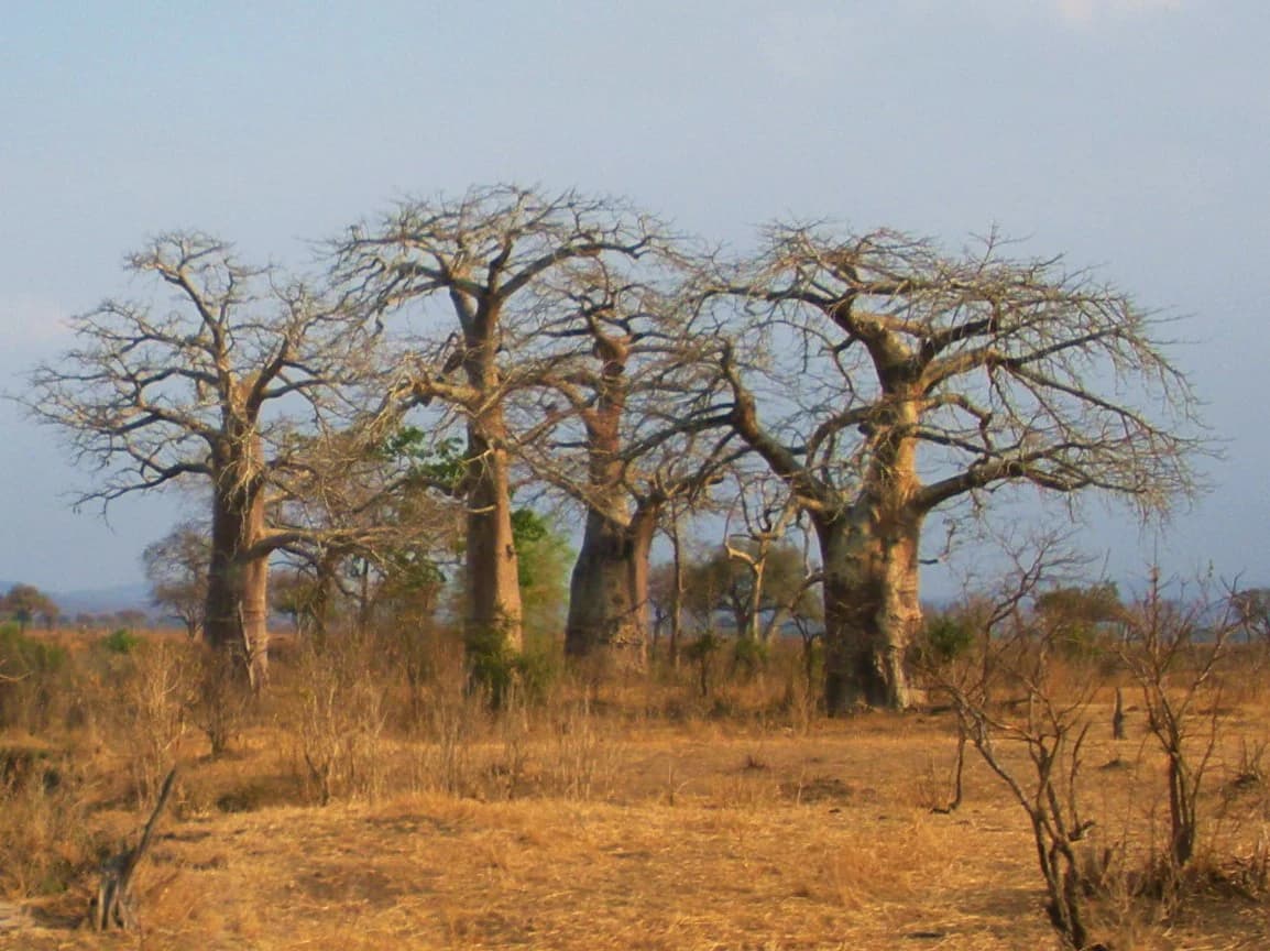
Mikumi National Park is best known for its role as a wilderness corridor connecting with the Selous Game Reserve, creating one of Africa's most significant protected savannah ecosystems. The park is distinguished by its population of a unique giraffe subspecies that represents a biological link between the Masai giraffe and the reticulated giraffe. The dramatic baobab-studded savannah landscape, often compared to the Serengeti, provides habitat for large herds of elephants, buffalo, zebra, and wildebeest. The park also features artificial hippo pools that support significant hippopotamus populations, and its location between the Uluguru and Udzungwa mountain ranges adds ecological complexity to the typical East African savannah character.

Mikumi National Park history and protected-area timeline

Mikumi National Park was established in 1964, marking Tanzania's commitment to preserving representative samples of its diverse ecosystems beyond the already-protected Serengeti and other northern circuit parks. The creation of Mikumi reflected growing recognition of the southeastern region's ecological value, particularly its connection to the extensive Selous Game Reserve. Following Tanzania's independence and the consolidation of its wildlife conservation framework, Mikumi was designated as a national park under the country's protected area legislation, placing it under the management of what is now the Tanzania National Parks Authority. The park's establishment preceded the formalization of the Selous ecosystem connection but ultimately created one of Africa's largest contiguous protected landscapes when combined with the game reserve. Over the decades, Mikumi has maintained its protected status while developing visitor infrastructure to support sustainable tourism that contributes to local conservation funding.

Mikumi National Park landscape and geographic character

Mikumi National Park presents a classic East African savannah landscape characterized by rolling grasslands, scattered woodland, and distinctive flat-topped acacia trees against a backdrop of distant mountains. The park's terrain is dominated by the Mkata River basin in the northwestern region, where alluvial plains support more lush vegetation and provide crucial water resources for wildlife during the dry season. The landscape features spectacular baobab trees, some of which are centuries old, standing as landmarks across the savannah. A prominent geological feature is Malundwe Mountain, a ridge running north-south with three peaks, the southernmost being the park's highest point at 1,290 meters elevation. This mountain, part of a chain of hills connecting the Uluguru Mountains to the northeast with the Udzungwa and Uvidunda mountains to the west, provides elevated terrain and rocky outcrops that contrast with the surrounding plains. The southeastern portion of the park offers more rugged and less-accessible terrain, with the impressive Rubeho and Uluguru mountain formations visible on the horizon. The park's vegetation zones include tall grass savannah in the river plains, mixed woodland on the higher ground, and thicker bushland in the southeastern sector.

Mikumi National Park ecosystems, habitats, and plant life

The ecological character of Mikumi National Park reflects its position within the Zambezian regional floristic zone, supporting a blend of savannah and woodland habitats that sustain remarkable biodiversity. The park's vegetation communities include extensive stands of acacia woodland, where species such as Acacia tortilis and Acacia nilotica dominate the canopy, interspersed with areas of grassland that undergo seasonal transformations following rainfall patterns. The baobab trees, particularly prominent in certain areas, represent an iconic element of the park's aesthetic and provide ecological functions as nesting sites and food sources for various species. The Mkata River and its associated wetlands create riparian corridors that support different plant communities than the surrounding savannah, providing habitat diversity within the broader protected area. The park's position between mountain ranges creates an ecological gradient from lower-elevation savannah to higher-elevation woodland, allowing species with different habitat preferences to coexist within the park's boundaries. This environmental diversity, combined with the contiguity with Selous, makes Mikumi part of one of the most ecologically significant savannah ecosystems in Africa.

Mikumi National Park wildlife and species highlights

Mikumi National Park supports a diverse mammalian community characteristic of East African savannah ecosystems, with particular significance attached to its giraffe population. The park contains a giraffe subspecies that scientists consider represents an evolutionary link between the Masai giraffe found in more southerly regions and the reticulated giraffe of northern Kenya, making this population biologically significant for understanding giraffe evolution and hybridization patterns. Large mammals are well-represented, with herds of African bush elephants moving across the plains, common eland and greater kudu occupying the woodland areas, and substantial populations of African buffalo forming defensive aggregations. The park supports healthy populations of Burchell's zebra and blue wildebeest, whose seasonal movements echo the greater migrations occurring in the Serengeti ecosystem. Primate species include baboons and other monkeys in the woodland areas, while the artificial pools near the park's northern boundary provide critical habitat for hippopotamus, allowing these large semi-aquatic mammals to persist in reasonable numbers. The avifauna is particularly notable, with more than 400 species recorded, reflecting the park's diverse habitats from riverine areas to open savannah. This bird diversity includes both resident species and migratory visitors that utilize the park's resources throughout the year.

Mikumi National Park conservation status and protection priorities

Mikumi National Park plays a crucial role in Tanzania's conservation framework by protecting a representative portion of the country's southeastern savannah ecosystems and maintaining ecological connectivity with the larger Selous Game Reserve. This transboundary relationship is particularly important for wide-ranging species that require large territories, including elephants, giraffes, and other migratory mammals that move seasonally between wet-season grazing areas and dry-season refuges. The park's giraffe population holds special conservation significance given its position as a potentially transitional population between recognized subspecies, raising questions about genetic integrity and the appropriate management approach for such populations. The park's position within a mountainous corridor between the Uluguru and Udzungwa mountains also contributes to conservation of catchments that supply water to surrounding communities, adding ecosystem service value beyond wildlife protection. As part of Tanzania's national park system, Mikumi receives management attention and resources through the Tanzania National Parks Authority, though conservation challenges include managing human-wildlife interactions at park boundaries and maintaining habitat integrity in the face of regional development pressures.

Mikumi National Park cultural meaning and human context

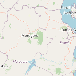
Mikumi National Park exists within a region of Tanzania with rich cultural heritage, though the park itself was established on land that had already undergone changes from historical land-use patterns. The surrounding areas include communities whose traditional livelihoods have included pastoralism and small-scale agriculture, relationships that continue to influence land use in the park's periphery. The park's proximity to Morogoro, one of Tanzania's major regional cities, creates economic connections that influence both local livelihoods and visitor access. The mountain ranges bordering the park, including the Uluguru and Udzungwa mountains, are home to communities with distinct cultural identities and traditional relationships to the land. While the park area itself was not specifically designated to protect cultural heritage sites, the broader landscape holds significance for understanding human settlement patterns and land-use evolution in this part of Tanzania. The park provides employment opportunities for local communities and generates revenue that supports regional development, creating ongoing relationships between conservation objectives and community welfare.

Top sights and standout views in Mikumi National Park

Mikumi National Park offers exceptional wildlife viewing opportunities in a setting that combines accessibility from Dar es Salaam with genuine wilderness character. The park's giraffe populations, particularly the unique subspecies bridging major taxonomic divisions, provide remarkable viewing opportunities for visitors interested in African megafauna. The landscape scenery, with its iconic baobab trees and savannah vista often compared to the Serengeti, delivers the visual experience that defines African protected areas in the popular imagination. The artificial hippo pools near the park's northern area offer reliable hippopotamus sightings, providing predictable wildlife encounters even during dry seasons when animals are more dispersed. The connection to Selous Game Reserve creates the possibility for extended wildlife circuits, allowing visitors to experience two major protected areas in a single journey. The mountain backdrop, particularly Malundwe Mountain and the distant Uluguru and Rubeho peaks, adds topographic drama to the savannah landscape and offers hiking opportunities for visitors seeking more active engagement with the terrain.

Best time to visit Mikumi National Park

Mikumi National Park can be visited throughout the year, though the optimal viewing conditions occur during the dry season from June to October when wildlife congregates around water sources and vegetation is less dense, facilitating animal sightings. The wet season from November through May brings seasonal transformations to the landscape, with new grass growth attracting concentrations of grazers and creating vibrant green scenery, though some roads may become difficult to traverse. The period immediately after the rains, typically November and December, offers excellent wildlife viewing as animals take advantage of fresh vegetation and reliable water sources. The park's location in southeastern Tanzania means it experiences slightly different weather patterns than the northern circuit parks, with the coastal influence moderating temperatures throughout the year. Visitors traveling from Dar es Salaam typically find the dry months most convenient for planning trips, as road conditions are more predictable and wildlife viewing yields more consistent results. Birdwatching is rewarding year-round, though the wet season brings migratory species and creates optimal conditions for observing breeding behavior among resident birds.

Park location guide

Geography guide, regional context, and park location map for Mikumi National Park

Mikumi National Park park geography, regions, and map view in Tanzania
Understand where Mikumi National Park sits in Tanzania through a broader geographic reading of the surrounding landscape, nearby location context, and its mapped position within the national park landscape.

How Mikumi National Park fits into Tanzania

Tanzania, officially the United Republic of Tanzania, is a presidential republic in East Africa within the African Great Lakes region. It was formed in 1964 through the unification of Tanganyika and Zanzibar. The country is known for its diverse wildlife, national parks including Serengeti and Ngorongoro, and significant archaeological sites with important hominid fossils.

Wider geography shaping Mikumi National Park in Tanzania

Tanzania is located in East Africa within the African Great Lakes region. It is bordered by Uganda to the northwest, Kenya to the northeast, the Indian Ocean to the east, Mozambique and Malawi to the south, Zambia to the southwest, and Rwanda, Burundi, and the Democratic Republic of the Congo to the west. The country includes the mainland and the Zanzibar Archipelago.

Map view of Mikumi National Park

Use this park location map to pinpoint Mikumi National Park in Tanzania, understand its exact geographic position, and read its mapped placement within the surrounding landscape more clearly.

Pigeon | © OpenStreetMap contributors

Location context for Mikumi National Park

Morogoro Region
Park atlas

Compare protected landscapes and their unique ecosystems across the greater Tanzanian savannah region.

Explore National Parks and Protected Areas Near Mikumi National Park, Tanzania
Discover other significant national parks and protected areas geographically adjacent to Mikumi National Park, tracing a network of conservation landscapes across southeastern Tanzania. Browse a curated list of nearby protected areas to compare diverse savannah habitats, mountain fringes, and transboundary ecosystems connected to Mikumi's unique environment.
National parkTanzania

Nyerere National Park: Tanzania's Immense Protected Area and Rufiji River Landscape

Explore the savanna and river delta geography of this national park.

Nyerere National Park represents one of Tanzania's most significant protected areas, sprawling across southeastern regions and offering a glimpse into largely untouched wilderness. The park's identity is deeply intertwined with the Rufiji River and its expansive delta, home to one of the world's largest mangrove forest systems. As a national park, its vastness and diverse terrain provide critical habitat, making it a key point for understanding protected land distribution and regional landscape context within Tanzania.

Area
30,893 km²
Established
2019
IUCN
II
National parkTanzania

Mkomazi National Park: Tanzania's Vast Protected Savanna Landscape and Wildlife Geography

Explore its mapped terrain and conservation significance within East Africa.

Mkomazi National Park is a critical protected landscape in Tanzania, spanning over 3,200 square kilometers of classic East African semi-arid savanna woodland. This national park offers a unique atlas-style view into conservation success, particularly for its black rhinoceros sanctuary and African wild dog programs. Its landscape is characterized by rolling terrain and Acacia-Commiphora vegetation, forming a vital transboundary conservation area with Kenya that supports significant wildlife migration corridors and provides a distinct geographic context within the broader regional atlas.

Area
3,234 km²
Established
2006
IUCN
II
National parkKenya

Kisite-Mpunguti Marine National Park: Kenya's Coastal Protected Marine Landscape

Mapped coral reefs and diverse marine ecosystems.

As Kenya's foremost marine national park, Kisite-Mpunguti Marine National Park presents an unparalleled opportunity to explore a thriving underwater world. Its protected boundaries encompass remarkable coral formations and a rich tapestry of marine species, including diverse fish populations, sea turtles, and dolphins. This park is a cornerstone of coastal conservation, offering valuable insights into marine geography and ecosystem health for those seeking detailed landscape context.

Area
39 km²
Established
1973
IUCN
II
National parkArusha Region

Lake Manyara National Park: Protected Landscape & Rift Valley Geography in Arusha Region

Unique habitats from groundwater forests to alkaline lake shores.

Lake Manyara National Park is a distinct protected landscape situated within the Great Rift Valley of Tanzania's Arusha Region. The park's geography is shaped by the imposing escarpment wall and the alkaline Lake Manyara, creating a mosaic of habitats including rare groundwater forests, acacia woodlands, and saline grasslands. Its unique environment supports diverse wildlife and offers a prime example of regional landscape context and protected area dynamics.

Area
648 km²
Established
1960
IUCN
II
Visitors
178.5K annual
Nature reserveMozambique

Niassa Reserve Nature Reserve: Mozambique's Expansive Protected Wilderness

Mapping the vast miombo woodlands and endemic species.

Niassa Reserve, a sprawling nature reserve in northern Mozambique, represents one of the largest miombo woodland ecosystems on Earth. Its diverse terrain encompasses dense forests, open savannahs, and riparian zones, making it a vital habitat for unique wildlife and a significant landmark in regional geography. The reserve's protected status and immense scale offer unparalleled opportunities for atlas-style exploration of its landscape and conservation importance.

Area
42,000 km²
Established
1954
IUCN
IV
National parkMara Region

Serengeti National Park: National Park Atlas and Protected Landscape Discovery

Explore savanna grasslands, regional geography, and mapped park boundaries.

Serengeti National Park, a significant national park within Tanzania's Mara Region, offers an unparalleled view into a vast protected landscape. This page provides access to the park's geographic identity, its defining savanna ecosystem, and its role as a critical component of the regional atlas. Understand the mapped extent of its protected boundaries and the unique natural context that supports its renowned wildlife.

Area
14,763 km²
Established
1940
IUCN
II
National parkKenya

Nairobi National Park: Detailed Geographic Overview and Protected Landscape Atlas

Explore the mapped boundaries and regional context of this Kenyan national park.

Nairobi National Park represents a significant protected national park entity within Kenya. This MoriAtlas entry provides detailed insight into its geographic placement and mapped landscape characteristics. Users can delve into the park's specific location, its protected boundaries, and its contribution to the regional geography of East Africa, facilitating structured map-based exploration and understanding of this vital conservation area.

Area
117 km²
Established
1946
IUCN
II
Relief
Mixed relief
National parkKatavi Region

Katavi National Park: A Vast Protected Landscape in Tanzania's Katavi Region

Explore its unique floodplains, seasonal wetlands, and wildlife spectacles.

Katavi National Park is a significant national park located in the Katavi Region of Tanzania, spanning over 4,471 square kilometers. This remote protected area is characterized by extensive floodplains, the vital Katuma River system, and seasonal lakes like Lake Katavi and Lake Chada, which undergo dramatic changes throughout the year. The park's geography supports a dynamic ecosystem renowned for its large wildlife populations, including spectacular hippo gatherings during dry periods and vast herds of buffaloes and elephants roaming its uncrowded savannas. Katavi offers an unparalleled glimpse into a wild, untamed African landscape.

Area
4,471 km²
Established
1974
IUCN
II

Common questions about visiting, size, designation, and location context for Mikumi National Park

Mikumi National Park FAQs for park facts, access, geography, and protected area context
Find quick answers about Mikumi National Park, including protected-area facts, park geography, trail and visitor context, and how the park fits into its surrounding country and regional landscape.
MoriAtlas Explorer

Continue Your Protected Areas Search Across the Global Atlas

Deepen your exploration by continuing the structured search for national parks and protected areas worldwide. Utilize the comprehensive filtering capabilities to compare different conservation landscapes and refine your understanding of global park geography. Discover more about the distribution and characteristics of protected natural areas.

Global natural geography