

Mori Atlas logo
National parkPinnacles National Park

Explore the dramatic rock formations and conservation importance of this national park in Queensland.

Pinnacles National Park: Queensland's Granite Landscape and Protected Area

Pinnacles National Park in Queensland, Australia, showcases a striking landscape dominated by ancient granite batholith formations that rise prominently from the Hervey Range. This protected national park covers rugged bushland, offering a unique terrain of exposed rock domes and tors. Established to preserve the scenic rim character and unique ecological heritage near Townsville, it serves as a vital conservation reserve, safeguarding habitats crucial for several threatened species, including the Sannantha papillosa plant and the black-throated finch.

granite formationsendangered speciesQueensland national parkHervey Rangedry woodland ecosystemrocky terrain

Pinnacles National Park

National park

Park overview

Structured park overview, official facts, and landscape profile for Pinnacles National Park

Pinnacles National Park park facts, protected area profile, and essential visitor context

Review the core facts for Pinnacles National Park, including designation, size, terrain, visitor scale, habitats, and operating context in one park-focused overview.

About Pinnacles National Park

Pinnacles National Park occupies a distinctive position in the protected area network of Queensland, safeguarding a representative sample of the Hervey Range's rugged bushland character. The park's landscape is defined by its geological foundation, where massive granite batholiths have been exposed through millions of years of erosion, creating the prominent pinnacles that give the area its name. These formations create a complex habitat mosaic of rock outcrops, crevices, and exposed surfaces interspersed with woodland and shrubland vegetation. The park was established specifically to protect this scenic landscape and the biodiversity it supports, representing a relatively recent addition to Queensland's national park estate. Located within the City of Townsville, the park serves as an important green space near a major regional center while maintaining its wilderness character and ecological integrity.

Quick facts and research context for Pinnacles National Park

Pinnacles National Park spans 1,337 hectares on the Hervey Range in the City of Townsville, Queensland. The park is named for its striking exposed granite batholiths, which create a distinctive dome-shaped landscape. It was formally gazetted in 2011 as part of a regional conservation initiative. The protected area harbors endangered flora and fauna, including the plant Sannantha papillosa and the black-throated finch (Poephila cincta).

Protection and recognition

Analyzing the official terrestrial boundary timeline and management designations since 2011.

Documented Protection Status and Geographic Designation of Pinnacles National Park

Map the formal terrestrial protection status and administrative framework established for Pinnacles National Park during its official designation in 2011. Verified data points track the spatial conservation limits and global database status to support accurate geographical research and regional comparison.

Protection details

Protection scope
Terrestrial
Designated year
2011
Transboundary protection
No
Park context

Deeper park guide and search-rich context for Pinnacles National Park

Pinnacles National Park history, landscape, wildlife, and travel context

Explore Pinnacles National Park through its history, landscape character, ecosystems, wildlife, conservation priorities, cultural context, and seasonal travel timing in a structured park guide built for atlas discovery and search intent.

Why Pinnacles National Park stands out

Pinnacles National Park is best known for its remarkable granite batholith formations that dominate the landscape and give the park its name. These ancient igneous rock intrusions create a striking visual feature, with rounded domes and exposed rock surfaces contrasting against the surrounding woodland. The park is also recognized for its conservation role in protecting two endangered species: the Sannantha papillosa plant and the black-throated finch, a ground-dwelling bird species of particular conservation concern in Queensland.

Pinnacles National Park history and protected-area timeline

Pinnacles National Park was gazetted in March 2011, representing the culmination of a coordinated effort to protect the scenic bushland character of Townsville's surrounding landscape. The establishment of the park marked the beginning of a systematic approach to conservation in the Hervey Range area, recognizing both the geological significance of the granite formations and the ecological values they support. The naming of the park directly references its most prominent landscape feature, the exposed granite batholiths that have become an identifiable landmark in the region. This protected area designation reflects a growing awareness in Queensland of the importance of preserving bushland remnants near urban centers for both ecological and recreational purposes.

Pinnacles National Park landscape and geographic character

The landscape of Pinnacles National Park is characterized by its dramatic granite batholith formations that rise from the ridge and eastern slopes of the Hervey Range. These ancient igneous rock bodies create a distinctive terrain of domed rock exposures, granite tors, and scattered boulder fields. The underlying geology influences both the visual character of the landscape and the distribution of soils, vegetation, and wildlife habitats. Between the rock outcrops, the terrain supports woodland and shrubland typical of the dry tropical environment of inland northern Queensland. The contrast between the stark, light-colored granite surfaces and the darker green vegetation creates a visually striking landscape that is particularly notable from viewpoints within and approaching the park.

Pinnacles National Park ecosystems, habitats, and plant life

The park protects an ecological community adapted to the challenging conditions of the Hervey Range environment. The vegetation includes patches of woodland and shrubland that provide habitat for the park's notable species. The park's conservation significance is particularly tied to two endangered species: the plant Sannantha papillosa and the bird Poephila cincta, commonly known as the black-throated finch. These species represent the park's highest conservation priorities and justify its protected area status. The granite landscape creates specialized microhabitats that support biodiversity distinct from the surrounding lower-elevation terrain.

Pinnacles National Park wildlife and species highlights

Pinnacles National Park provides critical habitat for several species of conservation concern, most notably the black-throated finch (Poephila cincta), which is listed as endangered. This ground-dwelling finch species relies on specific habitat conditions within the park's woodland and shrubland communities. The endangered plant Sannantha papillosa also occurs within the protected area, representing a significant botanical conservation value. The granite formations and associated vegetation communities support a diversity of other wildlife, though detailed species lists are limited in the available source material. The combination of rock outcrops for shelter and surrounding woodland for feeding makes the park a valuable refugium for fauna in the Townsville region.

Pinnacles National Park conservation status and protection priorities

The establishment of Pinnacles National Park in 2011 reflects a deliberate conservation strategy to protect the biological and scenic values of the Hervey Range area near Townsville. The park was created specifically to safeguard the endangered plant Sannantha papillosa and the endangered black-throated finch, both of which face significant pressures throughout their ranges. The protected area contributes to regional biodiversity conservation by preserving a representative sample of the granite ridge ecosystem and its associated communities. This conservation designation also helps maintain ecological connectivity in the landscape surrounding Townsville, providing refuge for species in an area where development pressure is ongoing.

Pinnacles National Park cultural meaning and human context

Pinnacles National Park is situated in the localities of Hervey Range and Granite Vale within the City of Townsville in northern Queensland. The area forms part of the broader Hervey Range region, which has historical significance in the Townsville area. The granite formations that give the park its name have been a notable feature of the local landscape well before European settlement and subsequent protected area establishment. The park contributes to the regional identity of the Townsville area by preserving a scenic and environmentally significant landscape element.

Top sights and standout views in Pinnacles National Park

The park's defining feature is its exposed granite batholith formations, creating a landscape of dramatic rock domes and tors that stand in contrast to the surrounding woodland. These geological formations provide both scenic value and specialized habitats for wildlife. The presence of two endangered species, the Sannantha papillosa plant and the black-throated finch, elevates the park's conservation importance beyond its relatively modest area. The park serves as a nature reserve near Townsville, offering residents and visitors access to a distinctive landscape while contributing to regional conservation goals.

Best time to visit Pinnacles National Park

The park can be visited year-round given Queensland's tropical climate, though the dry season from May to October typically offers more comfortable conditions for bushwalking and outdoor exploration. The cooler months reduce heat stress for visitors exploring the exposed granite formations. The wet season, from November to April, brings higher temperatures and humidity but also transforms the landscape with fresh vegetation growth. Visitors should be aware that conditions can change rapidly and should check current conditions before traveling.
Monthly climate preview

Long term temperature patterns and precipitation baselines in Queensland

Historical Climate Normals and Weather by Month for Pinnacles National Park

Long term records at the representative elevation of 132 meters show warm temperatures peaking above 35 degrees Celsius alongside a distinct seasonal cycle where precipitation drops significantly mid year. Comparing monthly climate averages from 1991 to 2020 helps map the broader regional weather patterns and environmental transitions across Queensland.
Annual mean24 °C
19 °C28 °C
Jan27°
Feb27°
Mar26°
Apr24°
May22°
Jun20°
Jul19°
Aug20°
Sep23°
Oct25°
Nov26°
Dec28°
Warmest month
December

27.5 °C

Coolest month
July

19.4 °C

Wettest month
February

8.6 mm/day

Driest month
September

0.4 mm/day

Park location guide

Geography guide, regional context, and park location map for Pinnacles National Park

Pinnacles National Park park geography, regions, and map view in Australia

Understand where Pinnacles National Park sits in Australia through a broader geographic reading of the surrounding landscape, nearby location context, and its mapped position within the national park landscape.

How Pinnacles National Park fits into Australia

Australia is a constitutional monarchy and federal parliamentary democracy comprising six states and ten territories. With a population of nearly 28 million, it is one of the world's most urbanised countries, with most people concentrated on the eastern seaboard. The country has a high Human Development Index and is known for its cultural diversity, ancient Aboriginal heritage, and unique wildlife.

Wider geography shaping Pinnacles National Park in Australia

Australia occupies the entire Australian continent, the island of Tasmania, and numerous smaller islands. It is the world's flattest and driest inhabited continent, featuring vast deserts in the interior (the Outback), tropical rainforests along the eastern coast, and a coastline bordering the Indian and Pacific Oceans.

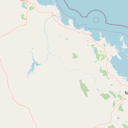
Map view of Pinnacles National Park

Use this park location map to pinpoint Pinnacles National Park in Australia, understand its exact geographic position, and read its mapped placement within the surrounding landscape more clearly.

Pigeon | © OpenStreetMap contributors

Location context for Pinnacles National Park

City of TownsvilleQueensland
Park atlas

Compare other protected areas within the Hervey Range and explore the regional park geography of northern Queensland.

Explore Other National Parks and Protected Areas Near Pinnacles National Park, Queensland

After exploring the granite formations of Pinnacles National Park, browse other national parks and protected areas within the Hervey Range and the broader dry tropical woodland ecosystems of northern Queensland. Compare adjacent conservation landscapes, trace regional park geography, and uncover similar geological features or unique habitats across Australia's protected lands.
Watercolor illustration of rolling green hills, a winding river, and distant mountains with trees and grassy areas
National parkQueensland
About 17 km away#1 closest

Northwest

Paluma Range National Park: Queensland National Park Landscape & Geography

Explore protected area boundaries and regional context.

Paluma Range National Park represents a key protected landscape within Queensland, Australia, ideal for atlas-style exploration of its natural geography. Understanding this national park involves examining its mapped boundaries and appreciating its role in the regional geographic context of northeastern Australia. This entry serves as a primary point for discovering the park's protected status and its specific landscape identity within the vast Queensland region.

Area
172 km²
Established
1994
IUCN
II
Relief
Mountain
Marine protected areaQueensland
About 28 km away#2 closest

Northeast

Great Barrier Reef Marine Park: Atlas and Geographic Context for Queensland Protected Waters

Exploring the reef system and marine conservation zones in northeastern Australia

The Great Barrier Reef Marine Park stands as an internationally significant marine protected area. By spanning a massive stretch of the Queensland coast, this protected landscape provides a critical framework for marine governance and reef conservation. Users can examine the unique zoning and distribution of coral reef habitats that define this extensive tropical ecosystem.

Area
343,966 km²
Established
1975
Climate
Tropical
Scope
Marine
National parkAustralia
About 38 km away#3 closest

Northeast

Magnetic Island National Park: Australia's Mapped Protected Landscape and Geographic Identity

Explore the natural terrain and park boundaries of this Australian national park.

Magnetic Island National Park is an Australian protected area offering a distinct geographic perspective for atlas exploration. Delve into its mapped boundaries and unique natural landscape to understand its role within Australia's protected lands. This entry provides essential context for appreciating the park's specific terrain and its contribution to the nation's conservation geography, enhancing your understanding of Australia's diverse natural heritage.

National parkQueensland
About 40 km away#4 closest

Northeast

Bowling Green Bay National Park: Queensland National Park and Protected Landscape Atlas

Mapped geographic context and protected area information for Queensland.

Bowling Green Bay National Park represents a distinct national park entity within the northeastern Australian state of Queensland. This page provides essential geographic context, focusing on the park's mapped boundaries and its identity as a protected landscape. Understand its regional setting and contribute to a structured atlas of Australia's natural and protected areas through detailed park geography.

Area
554 km²
Established
1977
IUCN
II
Relief
Mountain
National parkQueensland
About 64 km away#5 closest

Southwest

Dalrymple National Park: Queensland National Park Atlas and Protected Landscape

Explore mapped boundaries and regional park geography.

Dalrymple National Park stands as a distinct national park entity, offering valuable insights into Queensland's protected landscapes. This page serves as a gateway to understanding its specific geographic characteristics, mapped outlines, and its place within the structured atlas of Australia's natural areas. Discover the park's contribution to regional conservation and landscape context.

Area
16.6 km²
Established
1990
IUCN
II
Relief
Mixed relief
National parkQueensland
About 66 km away#6 closest

Northwest

Halifax Bay Wetlands National Park: Queensland's Vital Spawning Grounds and Coastal Wetlands

Mapped protected boundaries and tropical wetland ecosystems.

Halifax Bay Wetlands National Park represents a crucial component of Queensland's protected areas, focusing on the conservation of coastal wetland and shallow marine habitats. This national park is renowned for its role as a primary spawning ground for numerous fish species of significant ecological and economic importance, such as barramundi. Its landscape, characterized by mangrove ecosystems and tidal flats, offers a distinct perspective on tropical coastal environments within the Australian geographic atlas. Discover the mapped extent and ecological value of this important marine conservation site.

Area
4.47 km²
Established
1994
IUCN
II
Relief
Lowland
National parkQueensland
About 74 km away#7 closest

North

Orpheus Island National Park: Protected Landscape in Northeastern Australia

Explore Queensland's island geography and park boundaries.

Orpheus Island National Park serves as a significant protected area within Queensland, Australia, offering a focused entry point for atlas and geographic exploration. This national park's distinct island landscape provides context for understanding protected territories in northeastern Australia, contributing detailed mapped boundaries and regional geographic information. Users interested in Australia's protected natural areas will find this an essential component for mapping landscape distributions.

Area
13 km²
Established
1960
IUCN
II
Relief
Lowland
National parkQueensland
About 96 km away#8 closest

Northwest

Girringun National Park: Queensland Protected Area Atlas and Geographic Exploration

Discover mapped terrain and natural landscapes within northeastern Australia.

Girringun National Park stands as a significant protected landscape within Queensland, Australia, contributing to the nation's network of conservation areas. This park offers a focused lens through which to examine the geography of northeastern Australia, providing insights into its mapped boundaries and natural terrain. Users can leverage this park detail page to understand its role within the broader regional atlas and explore its distinct protected-area identity.

Area
1,538 km²
Established
1994
Relief
Mountain
Climate
Tropical

Common questions about visiting, size, designation, and location context for Pinnacles National Park

Pinnacles National Park FAQs for park facts, access, geography, and protected area context

Find quick answers about Pinnacles National Park, including protected-area facts, park geography, trail and visitor context, and how the park fits into its surrounding country and regional landscape.
MoriAtlas Explorer

Continue Your Protected Areas Search Across the Global Atlas

Deepen your exploration by continuing the structured search for national parks and protected areas worldwide. Utilize the comprehensive filtering capabilities to compare different conservation landscapes and refine your understanding of global park geography. Discover more about the distribution and characteristics of protected natural areas.

Global natural geography
