Mori Atlas logo
National parkWoraksan National Park

Trace the mapped boundaries and diverse terrain of this significant South Korean national park.

Woraksan National Park: Protected Mountain Landscape and Regional Geography in Gyeongsangbuk-do

Woraksan National Park stands as a vital protected area within the geographic atlas of South Korea, centered on the prominent Mount Worak in Gyeongsangbuk-do. This national park encompasses a rugged mountain terrain characterized by steep ridgelines, deep valleys, and dense, seasonally vibrant forests. Its role as a critical conservation zone preserves a rich biodiversity, making it a key site for understanding regional natural landscapes and protected area distribution.

mountain parkstemperate forestsSouth Korea national parksgranite landscapeshiking destinationsbiodiversity hotspots
Illustration showing a mountain peak, river, and forested hills under a pink sky with a setting sun

Woraksan National Park

National park

Park overview

Structured park overview, official facts, and landscape profile for Woraksan National Park

Woraksan National Park park facts, protected area profile, and essential visitor context
Review the core facts for Woraksan National Park, including designation, size, terrain, visitor scale, habitats, and operating context in one park-focused overview.

About Woraksan National Park

Woraksan National Park occupies a strategic position in the central-eastern region of South Korea, straddling the administrative boundary between Chungcheongbuk-do and Gyeongsangbuk-do provinces. The park's establishment in 1984 reflected South Korea's growing commitment to biodiversity conservation and natural landscape preservation during the 1980s. The protected area encompasses the Mount Worak massif and its surrounding forested slopes, incorporating valleys, stream systems, and the transition between different forest types that occur with increasing elevation. The Korea National Park Service maintains infrastructure including hiking trails that allow visitors to experience the park's landscapes while minimizing ecological impact. The park serves multiple conservation functions: protecting headwater ecosystems that feed downstream river systems, preserving forest habitat for wildlife populations, and maintaining scenic mountain landscapes that contribute to regional environmental quality. The geological character of the park, featuring granite bedrock and ancient metamorphic formations, creates the rugged topography that defines the Mount Worak landscape and supports the diverse habitats found within the protected area.

Quick facts and research context for Woraksan National Park

Woraksan National Park covers 287.78 square kilometres across two provinces in central-eastern South Korea. The park was established as South Korea's 17th national park in December 1984, with Mount Worak serving as the geographic and symbolic core of the protected area. The mountain rises to 1,094 metres and features rugged granite terrain with forested slopes descending into steep valleys. Biodiversity surveys have documented 1,200 plant species, 17 mammal species, 67 bird species, and more than 1,000 insect species within the park boundaries. Sixteen animal species found in the park are classified as endangered, reflecting the ecological significance of this mid-range mountain ecosystem within the Korean peninsula.

Park context

Deeper park guide and search-rich context for Woraksan National Park

Woraksan National Park history, landscape, wildlife, and travel context
Explore Woraksan National Park through its history, landscape character, ecosystems, wildlife, conservation priorities, cultural context, and seasonal travel timing in a structured park guide built for atlas discovery and search intent.

Why Woraksan National Park stands out

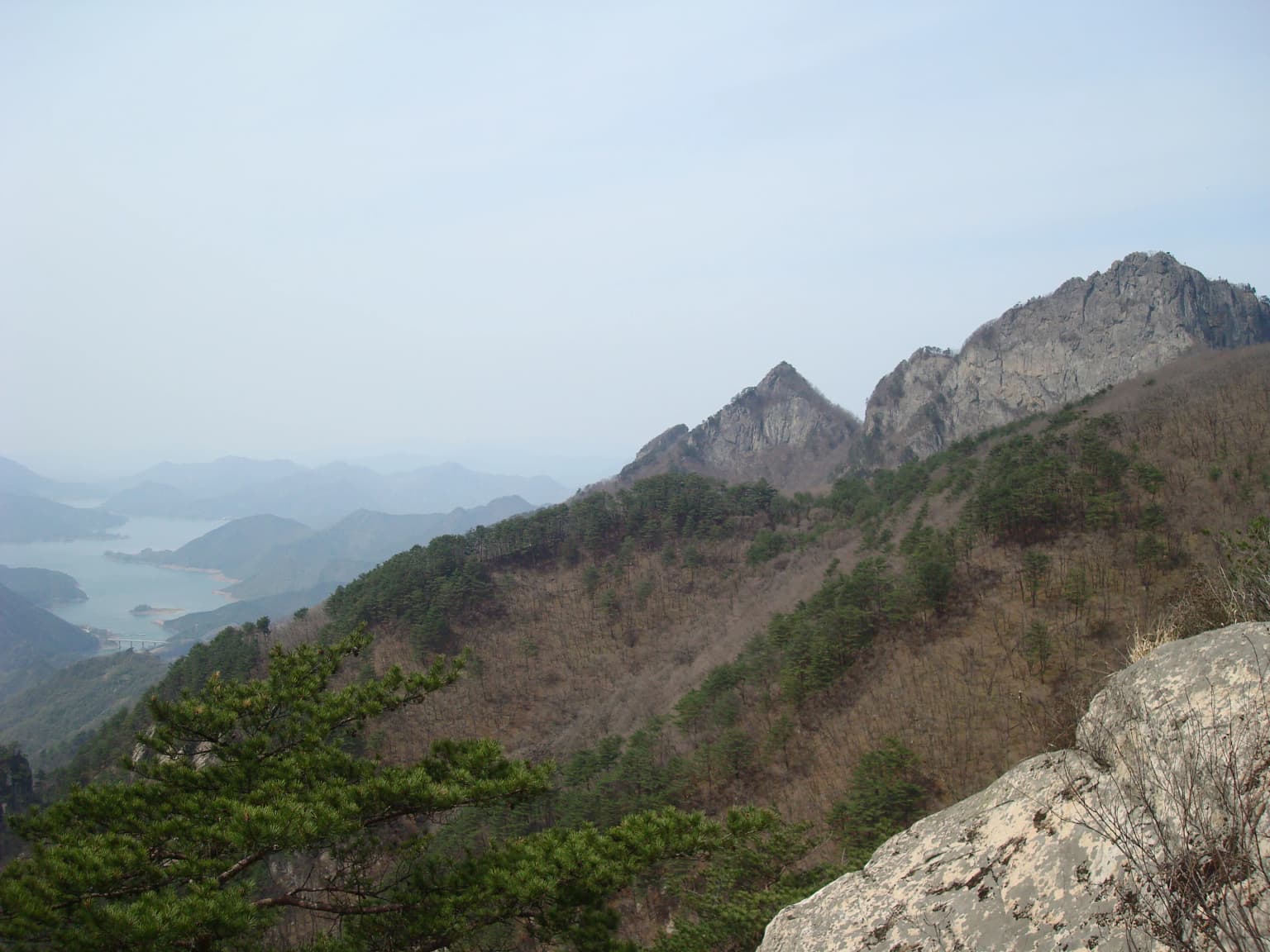
Woraksan National Park is best known for its densely forested mountain landscape dominated by deciduous and mixed forest communities that display vivid seasonal color changes throughout the year. The park's defining feature is the prominent ridgeline of Mount Worak, which rises dramatically from the surrounding terrain and offers panoramic views from its upper reaches. The mountain's steep granite cliffs and rocky outcrops create distinctive visual landmarks within the park. The park is particularly recognized for its biodiversity significance, harboring over 1,200 plant species within a relatively compact protected area and supporting populations of endangered species including the Korean goral and various raptor species. The combination of accessible hiking trails, ecological diversity, and the mountain's striking profile makes Woraksan a notable destination within South Korea's national park system.

Panoramic view of Mount Worak with rocky peaks, forested slopes, and a body of water in the distance
Panoramic view of Mount Worak in Woraksan National Park

Woraksan National Park history and protected-area timeline

Woraksan National Park was designated as South Korea's 17th national park on 31 December 1984, reflecting a period when South Korea was systematically expanding its national park network to protect representative ecosystems and scenic landscapes across the country. The selection of Mount Worak and its surrounding terrain for protected area status acknowledged both the mountain's geological and ecological significance and its cultural importance within the regional landscape. Prior to national park designation, the forest ecosystems of the Mount Worak area had experienced various levels of human use, including timber extraction and traditional agricultural practices in lower elevations. The establishment of the park initiated a formal conservation regime that restricted certain activities within the protected boundary while providing for managed public access. The Korea National Park Service assumed management responsibility, implementing trail development, visitor facilities, and conservation programs designed to balance public enjoyment with ecological preservation. Over the subsequent decades, the park has maintained its protected status and continued to serve as a conservation anchor within the central-eastern region of South Korea.

Woraksan National Park landscape and geographic character

The landscape of Woraksan National Park is defined by the prominent peak of Mount Worak, a 1,094-metre mountain composed primarily of granite and ancient metamorphic rocks that form the visual centerpiece of the protected area. The mountain rises sharply from the surrounding lower terrain, creating dramatic ridgelines that extend along the main spine of the park. Steep-sided valleys radiate outward from the central peak, carved by seasonal water flow and giving the terrain a characteristic V-shaped cross-section typical of mountain streams in the region. The park's elevation range supports distinct vegetation zones, with deciduous broadleaf forest dominating lower elevations and transitioning to mixed forest communities at higher elevations. Rock outcrops and cliff formations are prominent features along the upper ridgelines, where exposed granite surfaces contrast with the surrounding forest cover. The overall impression is one of a densely forested mountain rising into rocky summit terrain, representative of the mid-range mountain landscapes that characterize much of eastern South Korea.

Woraksan National Park ecosystems, habitats, and plant life

The ecological character of Woraksan National Park reflects the temperate forest ecosystem that dominates the Korean peninsula's mountain environments. The park supports approximately 1,200 plant species, a remarkable diversity for a protected area of this size that reflects the confluence of different biogeographic influences and the variety of microhabitats created by the park's topographic complexity. Forest communities include oak, maple, and birch species at lower elevations, transitioning to pine and mixed conifer stands at higher elevations. The park encompasses headwater streams and riparian corridors that connect different habitat types and provide critical water resources for both wildlife and downstream ecosystems. The combination of forest cover, rocky terrain, and water features creates a heterogeneous landscape that supports diverse ecological communities. The park's designation as a protected area has helped preserve these ecosystems from more intensive development pressures that have affected other regions of South Korea.

Woraksan National Park wildlife and species highlights

Woraksan National Park supports a diverse animal community documented through systematic biodiversity surveys. The park records 17 mammal species, 67 bird species, 10 amphibian species, 14 reptile species, 27 freshwater fish species, and 118 spider species. Of particular conservation significance, 16 animal species found within the park are classified as endangered, reflecting the ecological importance of this mountain habitat. Mammalian species include the Korean goral, a threatened ungulate adapted to steep mountainous terrain, as well as various small mammals that occupy the forest floor and canopy layers. Bird species include both resident and migratory forms, with raptors utilizing the open ridgelines for hunting and nesting. The park's stream systems support freshwater fish populations, while amphibian and reptile species occupy the moist valley environments and forest floor habitats. Insect diversity is particularly high, with over 1,000 species recorded, reflecting the diverse plant communities and varied habitat conditions present within the protected area.

Woraksan National Park conservation status and protection priorities

Woraksan National Park functions as an important conservation unit within South Korea's national park system, protecting a representative sample of the nation's temperate mountain ecosystems. The park's biodiversity significance is underscored by the presence of 16 endangered animal species, a notable concentration that reflects the ecological quality of the protected area. As a Category II protected area under IUCN classification, the park is managed primarily for ecosystem conservation while also providing for sustainable public use and environmental education. The Korea National Park Service implements management practices aimed at maintaining forest health, protecting water quality in stream systems, and preserving habitat conditions for threatened species. The park's location spanning two provinces requires coordination between different administrative jurisdictions, with management decisions reflecting both local conditions and national conservation priorities.

Woraksan National Park cultural meaning and human context

The Mount Worak area holds cultural significance within the regional landscape of central-eastern South Korea, though the park itself is primarily oriented toward natural landscape preservation rather than explicit cultural heritage protection. The mountain has historically been part of the spiritual and aesthetic landscape appreciated by local communities, consistent with the traditional Korean appreciation for mountain scenery that is reflected in historical art and literature. Place names in the region incorporate both Korean and traditional Hanja characters, with 월악산 (Woraksan) and its Hanja equivalent 月岳山 (Woraksan) reflecting the long history of written records referring to this landscape. The establishment of the national park in 1984 marked a transition in how the mountain and surrounding landscape were conceptualized and managed, shifting from primarily extractive uses toward conservation-oriented management that emphasizes ecological preservation and public enjoyment of the natural environment.

Top sights and standout views in Woraksan National Park

Woraksan National Park offers visitors an accessible mountain hiking experience within a landscape of significant ecological value. The Mount Worak summit provides a clear destination for hikers, with trails ascending through changing forest environments to reach panoramic viewpoints from the upper ridgelines. The park's biodiversity, including over 1,200 plant species and numerous endangered animals, represents a living ecosystem that visitors can observe while exploring the trail network. The seasonal changes in the park are particularly notable, with spring wildflower displays, summer forest foliage, autumn color transitions, and winter snow on the upper peaks each creating distinct visitor experiences. The park's position between two provinces makes it accessible from multiple population centers, supporting its role as a regional recreation and environmental education destination.

Best time to visit Woraksan National Park

Woraksan National Park can be visited throughout the year, with each season offering distinct character and conditions. Spring and early summer bring new foliage growth and wildflower displays in the lower elevation forests, while the mountain streams are at their most reliable flow following spring rainfall. Autumn provides perhaps the most visually striking conditions as the deciduous forests display vivid color changes, and many visitors time their trips to experience this seasonal transformation. Winter snow occasionally blankets the upper elevations, creating a different landscape character that appeals to visitors seeking a quiet, contemplative mountain experience. Summer months can be warm and bring more visitors to the park, though the forest shade provides some cooling relief on the lower trails. The shoulder seasons of spring and autumn generally offer the most pleasant hiking conditions and the most visually dynamic landscapes.

Park location guide

Geography guide, regional context, and park location map for Woraksan National Park

Woraksan National Park park geography, regions, and map view in South Korea
Understand where Woraksan National Park sits in South Korea through a broader geographic reading of the surrounding landscape, nearby location context, and its mapped position within the national park landscape.

How Woraksan National Park fits into South Korea

South Korea is a presidential republic on the Korean Peninsula in East Asia. It has a population of about 51 million and Seoul as its capital and largest city. The country is known for its rapid economic development, high technology industry, and cultural exports.

Wider geography shaping Woraksan National Park in South Korea

South Korea occupies the southern half of the Korean Peninsula in East Asia. It borders North Korea along the Demilitarized Zone to the north, the Yellow Sea to the west, and the Sea of Japan to the east. The terrain is predominantly mountainous with coastal plains along the southern and eastern shores.

Map view of Woraksan National Park

Use this park location map to pinpoint Woraksan National Park in South Korea, understand its exact geographic position, and read its mapped placement within the surrounding landscape more clearly.

Pigeon | © OpenStreetMap contributors

Location context for Woraksan National Park

Chungcheongbuk-doGyeongsangbuk-do

Gain visual insights into the park's prominent Mount Worak ridgelines, diverse forest communities, and distinct protected mountain environments.

Woraksan National Park Photo Gallery: Explore South Korea's Dramatic Mountain Scenery and Protected Forest Landscapes
View detailed photography of Woraksan National Park to understand its core landscapes, including the prominent Mount Worak peak, steep ridgelines, and diverse forest environments. Visualizing these protected area characteristics helps in comprehending the park's ecological significance and its distinctive physical geography.

Panoramic view of Mount Worak with rocky peaks, forested slopes, and a body of water in the distance

Park atlas

Trace the mapped geography of adjacent national parks and distinct protected areas within South Korea.

Discover Nearby National Parks and Protected Landscapes Around Woraksan National Park
After exploring Woraksan National Park, browse other national parks and protected areas in South Korea's central-eastern region to understand the broader conservation landscape. Compare diverse mountain parks, temperate forests, and granite landscapes, gaining geographic context and insights into regional park distribution and ecological connectivity.
National parkChungcheongbuk-do

Sobaeksan National Park: A Protected Landscape within Chungcheongbuk-do

Explore its park boundaries and regional geography.

Sobaeksan National Park represents a crucial protected area within the mountainous terrain of Chungcheongbuk-do, South Korea. As a designated national park, it offers a valuable point of reference for understanding regional geographic distribution and landscape context across the Korean Peninsula. This park's identity as a protected natural landscape contributes significantly to the atlas-based exploration of conservation areas and their environmental settings.

Area
322.38 km²
Established
1987
IUCN
II
Relief
Mountain
National parkSouth Korea

Songnisan National Park: Mapped Protected Landscape and Geographic Context in South Korea

Discover South Korea's Songnisan National Park and its protected terrain.

Delve into the protected landscape of Songnisan National Park, a key national park entity in South Korea. This atlas-focused view highlights its mapped geographic boundaries and natural terrain, providing essential context for understanding conservation areas. Explore Songnisan National Park as a distinct protected region contributing to the country's diverse geography and mapped natural heritage.

Area
274.541 km²
Established
1970
IUCN
II
Relief
Mountain
National parkGangwon-do

Chiaksan National Park: National Park Protected Landscape and Geographic Context in Gangwon-do

Explore mapped boundaries and regional terrain.

Chiaksan National Park is a designated national park within South Korea's Gangwon-do region, offering a focused entry point for geographic discovery. This resource details the park's protected landscape, its mapped boundaries, and its relation to the surrounding natural terrain. Delve into the atlas-style context of Chiaksan National Park to understand its significance as a protected natural area within its regional geography.

Area
181.57 km²
Established
1984
IUCN
II
Relief
Mountain
National parkSouth Korea

Juwangsan National Park: Protected Mountain Landscape and Regional Geography in South Korea

Mapped terrain, park boundaries, and natural landscapes.

Juwangsan National Park is a protected natural area situated within South Korea's Taebaek mountain range, renowned for its steep valleys, waterfalls, and dense forests. This park offers a rich landscape context, showcasing dramatic ridgelines and providing a significant example of South Korea's protected mountain terrain. Discover its geographic placement, mapped protected boundaries, and the unique natural and cultural elements that define this national park.

Area
107.42 km²
Established
1976
IUCN
II
Relief
Mountain
National parkChungcheongnam-do

Gyeryongsan National Park: Mapped Protected Landscape in Chungcheongnam-do

Explore its national park designation and regional geography.

Gyeryongsan National Park is a formally protected national park in Chungcheongnam-do, South Korea. This page offers critical atlas context for understanding the park's geographic scope, mapped protected boundaries, and its significance as a natural landscape within the region. Examine the terrain and explore its regional context for a deeper appreciation of its protected status.

Area
64.71 km²
Established
1968
IUCN
II
Relief
Mountain
National parkGangwon-do

Odaesan National Park: South Korea's Protected Landscape and Geographic Context in Gangwon-do

Explore the mapped boundaries and regional terrain of this national park.

Access detailed geographic information and atlas-style exploration for Odaesan National Park, a protected National Park located in Gangwon-do, South Korea. Understand its distinct landscape character and mapped boundaries, contributing to a broader understanding of protected areas within the regional geography. This resource is designed for users interested in the specific geographic identity and mapped context of individual park entities.

Area
303.93 km²
Established
1975
IUCN
II
Relief
Mountain
National parkSouth Gyeongsang Province

Gayasan National Park: National Park Identity and Mapped Geographic Context in South Korea

Discover Protected Landscape and Regional Terrain

Gayasan National Park presents a distinct protected-area entity within South Gyeongsang Province, serving as a crucial point for atlas-driven geographic exploration. As a designated national park in South Korea, it offers insights into its specific mapped boundaries and the surrounding natural terrain. Understanding this park's role within the regional geography provides a foundational element for comprehending broader landscape patterns and protected land distribution across the country.

Area
167.6 km²
Established
1972
IUCN
II
Relief
Mountain
National parkJeollabuk-do

Deogyusan National Park: National Park Identity and Geographic Mapping

Explore its protected land boundaries and regional landscape context.

Examine Deogyusan National Park, a designated national park situated in the Jeollabuk-do region of South Korea. This entry provides critical geographic context, focusing on the park's mapped boundaries and its role as a protected landscape. Users can gain a structured understanding of its natural terrain and regional significance, contributing to a broader atlas of protected areas.

Area
231.65 km²
Established
1975
IUCN
V
Visitors
1M annual

Common questions about visiting, size, designation, and location context for Woraksan National Park

Woraksan National Park FAQs for park facts, access, geography, and protected area context
Find quick answers about Woraksan National Park, including protected-area facts, park geography, trail and visitor context, and how the park fits into its surrounding country and regional landscape.
MoriAtlas Explorer

Continue Your Protected Areas Search Across the Global Atlas

Deepen your exploration by continuing the structured search for national parks and protected areas worldwide. Utilize the comprehensive filtering capabilities to compare different conservation landscapes and refine your understanding of global park geography. Discover more about the distribution and characteristics of protected natural areas.

Global natural geography