Mori Atlas logo
National parkSetonaikai National Park

Discover the mapped geography and protected island environments of Japan's largest national park.

Setonaikai National Park: Japan's Vast Island Archipelago and Marine Protected Landscape

Setonaikai National Park represents Japan's first national park designation, safeguarding the intricate marine geography of the Seto Inland Sea. This expansive protected area encompasses thousands of islands, creating a unique archipelago landscape characterized by sheltered waters and dramatic coastal formations across multiple Japanese prefectures. Explore the mapped boundaries and discover the distinctive natural beauty and cultural significance of this exceptional marine national park.

Marine National ParkIsland ArchipelagoUNESCO World Heritage SiteCoastal ScenerySeto Inland SeaHistorical Shrines

Setonaikai National Park

National park

Park overview

Structured park overview, official facts, and landscape profile for Setonaikai National Park

Setonaikai National Park park facts, protected area profile, and essential visitor context
Review the core facts for Setonaikai National Park, including designation, size, terrain, visitor scale, habitats, and operating context in one park-focused overview.

About Setonaikai National Park

Setonaikai National Park represents a singular approach to protected area management, covering not a contiguous terrestrial landscape but rather a vast marine environment interspersed with thousands of islands across the Seto Inland Sea. The parks establishment in 1934 marked a pivotal moment in Japanese conservation history, as it became the nations first national park and set a precedent for protecting marine and coastal environments rather than focusing solely on mountain or wilderness areas. The park stretches across ten prefectures, encompassing portions of the inland sea waters and the islands that dot its surface, from the well-known Itsukushima in Hiroshima Prefecture to the smaller islands scattered throughout the archipelago. The Seto Inland Sea has served as a vital maritime route for centuries, connecting major urban centers and facilitating trade, which explains the dense population surrounding the park and the significant industrial development in the broader region. This historical human presence has shaped both the cultural landscape and the environmental challenges facing the park today. The parks management addresses the tension between protecting outstanding natural beauty and accommodating the ongoing human activities that have defined this region for generations.

Quick facts and research context for Setonaikai National Park

Setonaikai National Park spans ten prefectures across the Seto Inland Sea region, making it the largest and most geographically extensive national park in Japan. Established on March 16, 1934, it was Japan first national park and has since undergone several expansions, with the major 1950 expansion bringing the park to its present approximate extent. The park protects around 669 square kilometers of marine and island environments, featuring approximately 3,000 islands of varying sizes. The Seto Inland Sea itself is a semi-enclosed body of water known for its mild Mediterranean-like climate, relatively calm waters, and historical significance as a maritime transportation corridor. The park encompasses significant cultural sites, including multiple Shinto shrines and Buddhist temples that reflect the regions deep religious traditions.

Park context

Deeper park guide and search-rich context for Setonaikai National Park

Setonaikai National Park history, landscape, wildlife, and travel context
Explore Setonaikai National Park through its history, landscape character, ecosystems, wildlife, conservation priorities, cultural context, and seasonal travel timing in a structured park guide built for atlas discovery and search intent.

Why Setonaikai National Park stands out

Setonaikai National Park is best known for its extraordinary island-studded marine environment and the iconic Itsukushima Shrine with its floating torii gate, recognized as a UNESCO World Heritage Site. The park is celebrated for the Naruto whirlpools in Naruto Strait, one of Japan most impressive natural tidal phenomena where swirling currents create whirlpools up to 100 feet in diameter. The Setouchi Islands form the core of the parks identity, with their distinctive weathered granite formations, coastal pine forests, and centuries-old fishing communities. The parks landscape is defined by the interplay between the sheltered inland sea waters, the surrounding mountain backdrop including Mount Rokko, and the scattered islands that create a uniquely Japanese maritime aesthetic.

Setonaikai National Park history and protected-area timeline

Setonaikai National Park was established on March 16, 1934, as Japan first national park, representing a groundbreaking moment in the nations approach to environmental protection and public access to natural areas. The original 1934 designation covered a much smaller area than the present-day park, focused on the most scenic portions of the Seto Inland Sea. Sixteen years later, in 1950, a significant expansion roughly doubled the parks size to bring additional iconic sites within its boundaries, creating the foundation for the contemporary park extent. The park has continued to undergo minor expansions over the decades, reflecting ongoing recognition of the regions ecological and scenic significance. A pivotal moment in the parks cultural history came in 1996 when Itsukushima Shrine in Hiroshima Prefecture was inscribed as a UNESCO World Heritage Site, known as one of the top three most scenic spots in Japan. The mid-to-late twentieth century brought significant environmental challenges, as rapid economic growth in the 1960s and 1970s led to industrial contamination of both fresh and ocean waters throughout the region. Chemical runoff from agricultural operations introduced synthetic fertilizers, pesticides, and herbicides into the water system, while industrial sources contributed heavy metals that accumulated in the food chain. Beginning in the 1980s, concerted conservation efforts and stricter environmental regulations led to substantial improvements in water quality, though monitoring and management continue to be essential.

Setonaikai National Park landscape and geographic character

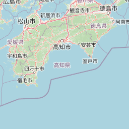
The landscape of Setonaikai National Park is fundamentally defined by its marine environment, the largest national park in Japan encompassing the semi-enclosed Seto Inland Sea and its constellation of islands. The Seto Inland Sea stretches between the main islands of Honshu and Shikoku, with its relatively shallow, calm waters creating ideal conditions for the development of island chains and coastal ecosystems. Approximately 3,000 islands of varying sizes dot the Inland Sea, ranging from tiny uninhabited islets to larger inhabited islands like Awaji Island, Shodoshima, and Naoshima. The islands display characteristic weathered granite terrain, often with dramatic rock formations sculpted by wind and waves over centuries. Coastal pine forests and evergreen vegetation clothe many island slopes, while the surrounding sea features a distinctive blue-green color typical of semi-enclosed marine environments. The park also includes several significant mountain areas on the mainland, notably Mount Rokko, Mount Maya, and Mount Noro in Hyogo Prefecture, which provide scenic backdrops to the coastal landscape. Notable straits including Naruto Strait, Akashi Strait, and the Kanmon Straits create dynamic water connections between the Inland Sea and the open Pacific, generating the tidal currents that produce the famous Naruto whirlpools.

Setonaikai National Park ecosystems, habitats, and plant life

The nature of Setonaikai National Park centers on its distinctive semi-enclosed marine ecosystem within the Seto Inland Sea, a region that supports unique biodiversity adapted to its sheltered coastal conditions. The Inland Sea maintains relatively mild temperatures throughout the year, earning it a Mediterranean climate classification with winters rarely dropping below freezing and summer temperatures typically remaining below 30 degrees Celsius. This moderate climate supports a variety of coastal and marine habitats, from rocky intertidal zones to seagrass beds and shallow tidal areas. The approximately 3,000 islands within the park create extensive shoreline habitat and support island-specific plant communities adapted to the maritime environment. The surrounding land areas include portions of mountainous terrain with their own distinct ecological character, supporting forests that contrast with the coastal and island environments. Water quality improvements since the 1980s have helped restore portions of the marine ecosystem that were degraded during the rapid industrialization period, though the overall health of the Inland Sea ecosystem remains an ongoing conservation concern given the extensive human population and industrial activity in the surrounding region.

Setonaikai National Park wildlife and species highlights

Wildlife within Setonaikai National Park is closely tied to the marine and island environments that define the protected area, with the Seto Inland Sea supporting a variety of coastal and ocean-dwelling species. The sheltered waters of the Inland Sea provide important habitat for numerous fish species, shellfish, and other marine invertebrates that have historically supported local fisheries. The islands serve as breeding and resting sites for seabirds, while the surrounding coastal areas and tidal zones attract shorebirds and waterfowl. The dynamic Naruto Strait, where strong tidal currents create the famous whirlpools, supports specialized marine life adapted to fast-moving waters. The surrounding mountains and forested areas on the mainland portions of the park provide habitat for terrestrial wildlife typical of Japanese coastal and lowland forests. While the park is not specifically noted for large charismatic megafauna, the overall biodiversity of the region reflects the combination of marine, coastal, and terrestrial habitats that characterize this extensive protected area.

Setonaikai National Park conservation status and protection priorities

Setonaikai National Park faces significant conservation challenges arising from its unique structure as a marine park encompassing a heavily populated and industrialized region. The parks designation covers only a tiny fraction of the total Seto Inland Sea area, leaving the majority of this semi-enclosed sea outside formal protection despite its ecological connections to the protected areas. This fragmented protection approach makes comprehensive ecosystem management difficult, as water quality, species movements, and habitat connections extend well beyond the officially designated park boundaries. The environmental degradation experienced during Japan rapid economic growth in the 1960s and 1970s, when industrial contamination and agricultural chemical runoff severely impacted water quality, represents a cautionary history that has informed subsequent conservation efforts. The improvements in water quality achieved since the 1980s through stricter regulations on chemical use and improved sewage treatment demonstrate the potential for recovery when appropriate management measures are implemented. Ongoing conservation work focuses on maintaining these gains, addressing remaining pollution sources, and working to expand protection to additional significant areas within the Inland Sea ecosystem.

Setonaikai National Park cultural meaning and human context

Setonaikai National Park contains exceptional cultural heritage reflecting the long human history of the Seto Inland Sea region, one of the most densely populated and historically significant areas of Japan. Itsukushima Shrine, with its iconic floating torii gate that appears to hover on the water surface at high tide, represents one of Japan most sacred Shinto sites and was inscribed as a UNESCO World Heritage Site in 1996, recognized as one of the three most scenic spots in the country. The park encompasses numerous additional shrines and temples that have shaped the spiritual landscape of the region for centuries, including Kotohira-gu, Mekari Shrine, and Buddhist temples such as Futago-ji and Yashima-ji. The islands and coastal areas of the Seto Inland Sea have supported maritime communities engaged in fishing, trade, and coastal agriculture for generations, creating cultural landscapes that interweave with the natural environment. The regions strategic importance as a maritime corridor has also meant that coastal fortifications, historic ports, and traditional boat-building practices contribute to the cultural fabric preserved within and adjacent to the park boundaries.

Top sights and standout views in Setonaikai National Park

Setonaikai National Park offers visitors remarkable experiences centered on its unique island-dotted marine environment and outstanding cultural sites. The iconic Itsukushima floating torii gate provides one of Japan most photographed and spiritually significant views, rising from the waters of the Inland Sea as a gateway to the sacred island shrine. The Naruto whirlpools in Naruto Strait represent one of the worlds most spectacular tidal vortex phenomena, where the narrow strait and powerful tidal currents create swirling whirlpools visible from the shore or by boat. The network of islands known as the Setouchi Islands can be explored via ferry, offering opportunities to visit art-rich Naoshima, the scenic landscapes of Shodoshima, and countless smaller islands with their distinctive coastal character. The parks span across ten prefectures and 55 cities allows visitors to experience vastly different facets of the Inland Sea region, from the urban waterfronts of Kobe and Hiroshima to quieter fishing communities on outer islands.

Best time to visit Setonaikai National Park

Setonaikai National Park can be visited year-round due to its mild Mediterranean-like climate, though certain seasons offer distinct advantages for different experiences. The spring months of March through May bring comfortable temperatures and the blooming of coastal flowers across the islands, making this an ideal time for sightseeing and island hopping. Summer, while warmer, provides the classic image of the Inland Sea with bright blue waters and active festival season, though this is also the peak tourist period. Autumn from September through November offers pleasant temperatures, reduced crowds, and the opportunity to experience the changing colors of the seasons along the island and coastal landscapes. Winter remains mild compared to other parts of Japan, with December through February offering fewer tourists and the chance to experience the more contemplative side of the parks islands and sacred sites. The famous Naruto whirlpools can be observed throughout the year, though their size and intensity vary with tidal patterns.

Park location guide

Geography guide, regional context, and park location map for Setonaikai National Park

Setonaikai National Park park geography, regions, and map view in Japan
Understand where Setonaikai National Park sits in Japan through a broader geographic reading of the surrounding landscape, nearby location context, and its mapped position within the national park landscape.

How Setonaikai National Park fits into Japan

Japan is an island nation in East Asia comprising over 14,000 islands in the Pacific Ocean. The country operates as a unitary parliamentary constitutional monarchy with Emperor Naruhito as the reigning monarch and Prime Minister Sanae Takaichi leading the government. With a population of approximately 123 million, Japan is the world's 11th most populous country and a major economic power with one of the strongest militaries, though it has constitutionally renounced its right to declare war.

Wider geography shaping Setonaikai National Park in Japan

Japan is an island nation in the Pacific Ocean, bordered to the west by the Sea of Japan and extending from the Sea of Okhotsk in the north to the East China Sea in the south. The Japanese archipelago lies off the northeast coast of the Asian mainland. Approximately 75% of Japan's terrain is mountainous and heavily forested, with agricultural land and urbanized populations concentrated along the eastern coastal plains. The country is divided into 47 administrative prefectures and eight traditional regions.

Map view of Setonaikai National Park

Use this park location map to pinpoint Setonaikai National Park in Japan, understand its exact geographic position, and read its mapped placement within the surrounding landscape more clearly.

Pigeon | © OpenStreetMap contributors
Park atlas

Compare Setonaikai National Park's distinctive marine geography with other protected areas and unique landscapes throughout Japan's Seto Inland Sea region

Discover Other National Parks and Protected Areas Near Setonaikai National Park
Continue your park discovery by exploring national parks and protected areas geographically close to Setonaikai National Park, including distinct marine and coastal landscapes. This expanded view helps compare conservation approaches and natural features across Japan's diverse regions, offering rich atlas-style geographic context.
National parkKansai

Yoshino-Kumano National Park: Protected National Park with Sacred Mountain Landscapes and Ancient Routes

Explore mapped park boundaries, gorges, and pilgrimage routes in Kansai.

Yoshino-Kumano National Park, a significant national park in Japan's Kansai region, invites exploration of its protected landscapes, which are deeply intertwined with spiritual heritage. Discover the park's rugged mountain terrain, ancient cypress and cedar forests, dramatic gorges like Dorokyō Gorge, and iconic coastal areas. This park is a vital entry for understanding Japan's confluence of natural geography and cultural pilgrimage, offering rich context for mapped landscape discovery.

Area
616.04 km²
Established
1936
IUCN
II
National parkNagasaki Prefecture

Unzen-Amakusa National Park: Volcanic Terrain and Island Geography

Explore Nagasaki Prefecture's Protected Landscape

Unzen-Amakusa National Park represents a significant protected area within Japan's geography, characterized by the imposing presence of Mount Unzen and the distinct maritime environment of the Amakusa islands. This national park offers an opportunity to study volcanic landscapes, coastal formations, and the rich cultural history intertwined with its natural setting. Understanding its mapped boundaries and geographic context provides valuable insight into Japan's protected lands and regional landscape diversity.

Area
282.79 km²
Established
1934
IUCN
II
National parkIshikawa Prefecture

Hakusan National Park: Sacred Mountain Protected Landscape in Ishikawa Prefecture

Mapped alpine terrain and volcanic geography for protected area discovery.

Hakusan National Park offers a unique exploration of Japan's sacred mountain heritage and alpine natural beauty. This protected landscape, centered on Mount Haku, features distinct volcanic terrain, crater lakes, and exceptional alpine flora. Users can explore the park's mapped boundaries, understand its place within Ishikawa Prefecture's geography, and appreciate its role as a significant UNESCO Biosphere Reserve for detailed atlas-based discovery.

Area
477 km²
Established
1962
IUCN
II
National parkSouth Korea

Juwangsan National Park: Protected Mountain Landscape and Regional Geography in South Korea

Mapped terrain, park boundaries, and natural landscapes.

Juwangsan National Park is a protected natural area situated within South Korea's Taebaek mountain range, renowned for its steep valleys, waterfalls, and dense forests. This park offers a rich landscape context, showcasing dramatic ridgelines and providing a significant example of South Korea's protected mountain terrain. Discover its geographic placement, mapped protected boundaries, and the unique natural and cultural elements that define this national park.

Area
107.42 km²
Established
1976
IUCN
II
National parkChūbu region

Minami Alps National Park: A Protected Alpine Wilderness in Japan's Chūbu Region

Discover its dramatic peaks and vital river headwaters.

Minami Alps National Park offers a profound exploration into Japan's high-altitude natural geography. As a national park, it preserves a dramatic alpine environment defined by glacially carved terrain and multiple peaks exceeding 3000 meters. This protected landscape serves as a vital watershed, safeguarding the origins of major river systems and showcasing a rugged mountain character distinct from more accessible areas, ideal for understanding protected wildlands.

Area
357.52 km²
Established
1964
IUCN
II
National parkKagoshima Prefecture

Yakushima National Park: Ancient Cedar Forests and Volcanic Mountain Landscape

Discover the mapped boundaries and protected area geography.

Yakushima National Park, situated in Kagoshima Prefecture, is a prime example of protected island geography, renowned for its ancient yakusugi cedar trees and dramatic mountainous terrain. The park's protected status covers over 32,000 hectares, featuring peaks over 1,900 meters and significant biodiversity. This atlas-focused entry helps users grasp the park's unique landscape context, its position within Japan's protected areas, and the essence of its natural environment for geographic exploration.

Area
325.53 km²
Established
2012
IUCN
II
National parkJapan

Fuji-Hakone-Izu National Park: Japan's Premier National Park with Diverse Volcanic Landscapes and Mapped Geography

Explore volcanic terrain, hot springs, islands, and Mount Fuji's iconic protected boundaries.

Fuji-Hakone-Izu National Park is a vast and diverse protected area in Japan, anchored by the iconic Mount Fuji. This national park features a remarkable range of volcanic landscapes, including natural hot springs, rugged coastlines, and the unique Izu Islands extending into the Pacific. Delve into its mapped geography and protected landscape identity for a comprehensive atlas-style understanding of this significant natural asset within Japan.

Area
1,227 km²
Established
1936
IUCN
II
National parkGyeongsangbuk-do

Woraksan National Park: A Key National Park in Gyeongsangbuk-do's Regional Geography

Discover its mapped mountain terrain and protected landscape identity.

Woraksan National Park offers a detailed view of protected mountain landscapes within South Korea's Gyeongsangbuk-do region. The park is characterized by its prominent Mount Worak, steep ridgelines, and dense forested terrain, contributing significantly to the nation's network of protected areas. Users can explore the geographic context, mapped boundaries, and ecological significance of this vital national park, understanding its place in the broader regional atlas and natural landscape context.

Area
287.78 km²
Established
1984
IUCN
II
Relief
Mountain

Common questions about visiting, size, designation, and location context for Setonaikai National Park

Setonaikai National Park FAQs for park facts, access, geography, and protected area context
Find quick answers about Setonaikai National Park, including protected-area facts, park geography, trail and visitor context, and how the park fits into its surrounding country and regional landscape.
MoriAtlas Explorer

Continue Your Protected Areas Search Across the Global Atlas

Deepen your exploration by continuing the structured search for national parks and protected areas worldwide. Utilize the comprehensive filtering capabilities to compare different conservation landscapes and refine your understanding of global park geography. Discover more about the distribution and characteristics of protected natural areas.

Global natural geography