Mori Atlas logo
National parkHakusan National Park

Discover mapped boundaries, alpine terrain, and pilgrimage heritage within Ishikawa Prefecture's national park.

Hakusan National Park: Explore Japan's Sacred Mountain and Volcanic Protected Landscape

(Hakusan Kokuritsu Kōen)

Hakusan National Park represents a significant protected mountain landscape in the Chūbu region of Honshū, Japan, centered around the sacred Mount Haku. This national park spans Ishikawa Prefecture and beyond, offering users an atlas-driven perspective on its dramatic elevation gradients, volcanic terrain, and rich alpine flora. Discover the park's mapped boundaries, ancient pilgrimage routes, and its ecological importance as a UNESCO Man and the Biosphere Reserve.

Mountain parkAlpine ecosystemSacred mountainJapanese national parkBiosphere ReserveOld-growth forest

Hakusan National Park

National park

Park overview

Structured park overview, official facts, and landscape profile for Hakusan National Park

Hakusan National Park park facts, protected area profile, and essential visitor context
Review the core facts for Hakusan National Park, including designation, size, terrain, visitor scale, habitats, and operating context in one park-focused overview.

About Hakusan National Park

Hakusan National Park protects a remarkable mountain ecosystem in central Japan where the Ryōhaku Mountains rise dramatically above the surrounding lowlands. The park's defining feature is Mount Haku, whose summit at 2,702 meters has attracted religious reverence for over thirteen centuries. According to historical records, the mountain was first opened for pilgrimage in 717 by the monk Taishō, and by 832, three distinct pilgrimage routes had been established from the provinces of Echizen, Kaga, and Mino, each beginning at a different shrine. These ancient trails, known as zenpōdō, remain as modern hiking routes and represent a continuous tradition of mountain worship that links Hakusan to Japan's spiritual heritage alongside Mount Tate and Mount Fuji.

The park encompasses approximately 49,900 hectares spanning four prefectures, with about 66 percent remaining as national land and 37 percent designated as special protection areas. The geography creates a complex mountain landscape with roughly 20 kilometers of east-west extent and 40 kilometers of north-south spread. The area sits within a heavy snow zone, with both Hakusan City and Shirikawa Village classified as special heavy snow areas under Japanese law. This climatic condition contributes to the park's ecological character, supporting forests that have remained largely undeveloped compared to other Japanese mountain regions.

visitor infrastructure includes several mountain huts and visitor centers, with the Hakusan Nature Conservation Center serving as the administrative hub in Hakusan City. The park contains multiple hot springs including Iwama Onsen, Nakamiya Onsen, and Hatoiga Onsen, adding to its recreational appeal. The Hakusan White Road (Hakusan Shirakawa-go White Road), a scenic mountain highway completed in 1977, provides vehicle access through the park and connects the surrounding communities.

Quick facts and research context for Hakusan National Park

Hakusan National Park covers 477 square kilometers across four prefectures in central Japan's Chūbu region. The park centers on Mount Haku, the highest peak in Ishikawa Prefecture, rising to 2,702 meters. The area experiences heavy snowfall and supports diverse vegetation zones from warm temperate forests to alpine environments. The park was established in 1962, evolving from a quasi-national park designated in 1955. It holds UNESCO Biosphere Reserve status since 1980. The region is home to several endemic species including the Japanese serow and features notable geological formations including volcanic crater lakes near the summit.

Park context

Deeper park guide and search-rich context for Hakusan National Park

Hakusan National Park history, landscape, wildlife, and travel context
Explore Hakusan National Park through its history, landscape character, ecosystems, wildlife, conservation priorities, cultural context, and seasonal travel timing in a structured park guide built for atlas discovery and search intent.

Why Hakusan National Park stands out

Hakusan National Park is best known for Mount Haku, one of Japan's three sacred mountains, which has been a pilgrimage site since the 8th century. The park is renowned for its exceptional alpine flora, with over twenty species bearing the name 'Hakusan' in their Japanese designations, reflecting the mountain's botanical significance. The park features spectacular waterfalls including several recognized among Japan's top hundred falls, and contains significant old-growth beech forests that remain largely undeveloped. The presence of Japanese serow, Japanese macaques, and raptors including golden eagles adds to the park's wildlife significance. The cultural landscape of ancient pilgrimage routes, particularly the three禅定道 (zenpōdō) trails that still function as hiking paths, distinguishes Hakusan from more purely natural mountain parks.

Hakusan National Park - Midagahara to Murododaira
View from Midagahara towards Murododaira in Hakusan National Park.

Hakusan National Park history and protected-area timeline

Hakusan National Park traces its protected area history to 1955 when it was first designated as Hakusan Quasi-National Park (白山国定公園). This initial designation reflected the recognition of the region's ecological and scenic value while the area remained under prefectural administration. Seven years later, on November 12, 1962, the area was elevated to full national park status, bringing it under direct national protection and management by Japan's Ministry of the Environment. This transition from quasi-national to national park status signified Japan's commitment to preserving the mountain landscape at the highest level of protected area designation.

In 1980, the park achieved additional international recognition when a 480-square-kilometer area corresponding to the national park was designated as a UNESCO Man and the Biosphere Reserve under the Man and the Biosphere Programme. This designation acknowledged both the ecological significance of the mountain ecosystems and the traditional human relationship with the landscape. The year 2022 marked the 60th anniversary of national park designation, commemorated by activities including a symbolic mountain ascent by the Ishikawa Prefecture governor. The park's management falls under the Chubu Regional Environment Office, headquartered in Nagoya, which coordinates conservation efforts across the multi-prefecture landscape.

Hakusan National Park landscape and geographic character

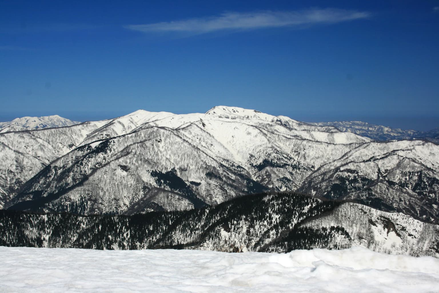
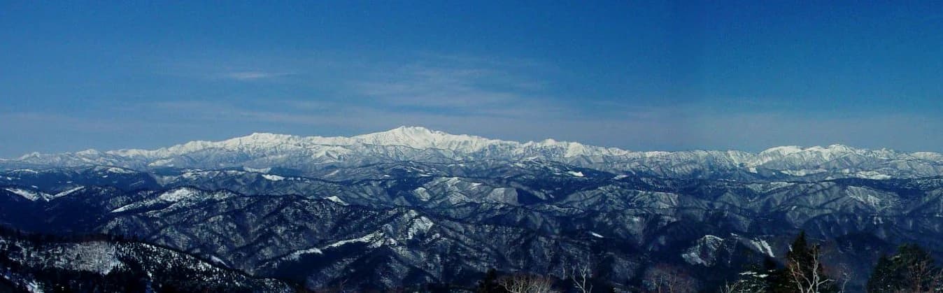
The Hakusan National Park landscape is defined by the Ryōhaku Mountains, a rugged mountain range in central Japan with Mount Haku as its highest peak. The terrain rises from approximately 300 meters in the lower foothills to 2,702 meters at the summit of Mount Haku (Gōzenmine), creating a dramatic vertical gradient that supports multiple ecological zones. The mountain range extends roughly 20 kilometers east to west and 40 kilometers north to south, with several notable peaks including Mount Bessan (2,399 meters), Mount Sanpōiwa (2,058 meters), and Mount Ōizurugatake (1,841 meters).

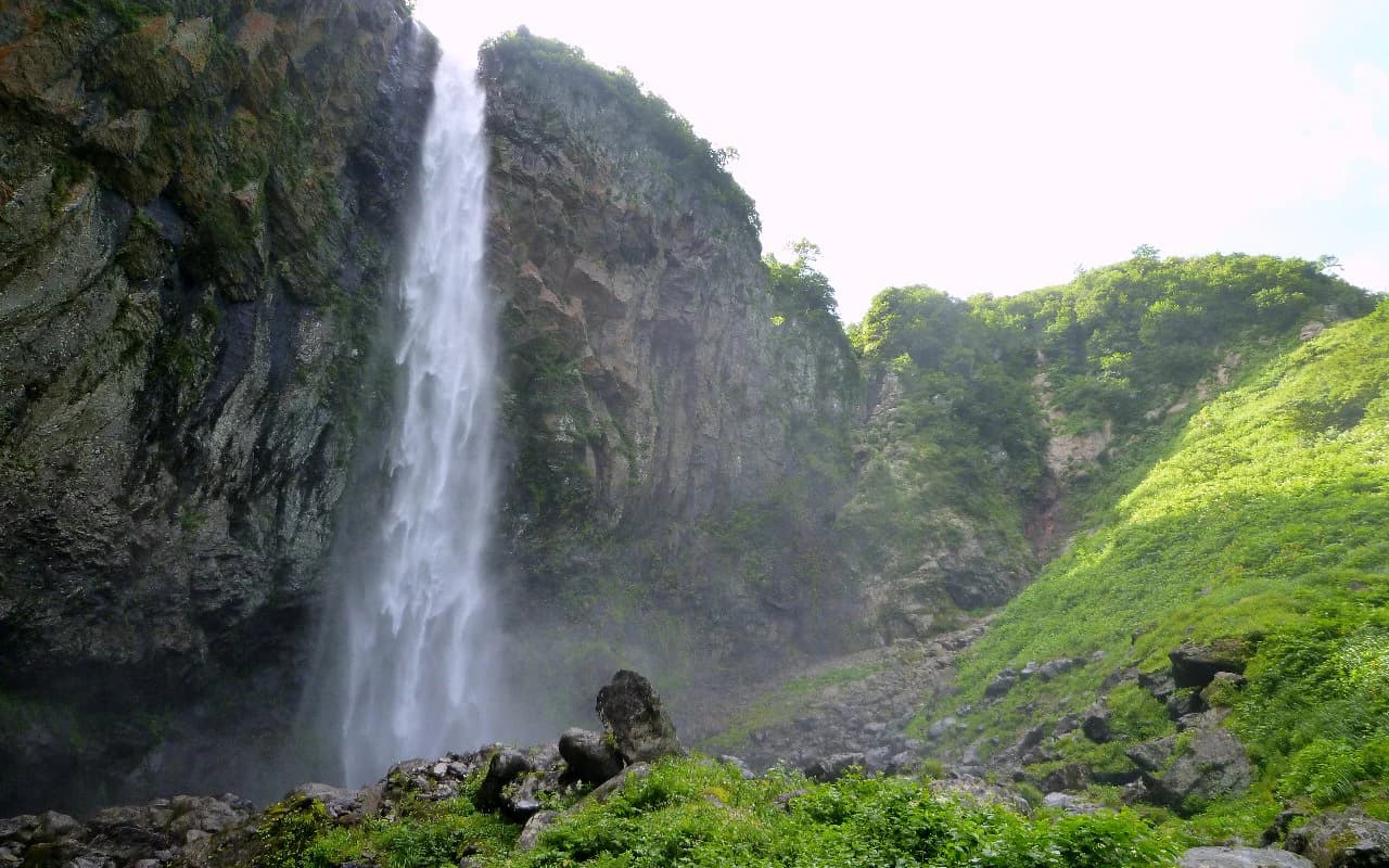
Near the summit, volcanic activity has created a series of eight crater lakes, including Midori-ike (翠ヶ池) and Konya-ike (紺屋ヶ池), which add geological interest to the alpine landscape. The mountain's last known eruption occurred in 1659, classifying Mount Haku as an active volcano monitored by the Japan Meteorological Agency. Below the alpine zone, the landscape features dense forests of Japanese beech (Fagus crenata) and mixed deciduous woodland, with coniferous forests dominated by firs, pines, and Japanese cedar covering the lower slopes. The park contains several significant waterfalls recognized among Japan's finest, including Uba-ga-taki (111 meters), Hyakuyōjō Falls (90 meters), and Shiramizu Falls (76 meters), all within the Tedori River watershed.

Capricornis crispus on Mt. Sanpoiwa
Japanese serow (Capricornis crispus) at the foot of Mt. Sanpoiwa.

Hakusan National Park ecosystems, habitats, and plant life

The ecological diversity of Hakusan National Park reflects its dramatic elevation range and position in central Japan. The park spans multiple vegetation zones from warm temperate forests at lower elevations through cool temperate deciduous forests to subalpine and alpine zones near the summit. The lower mountain slopes feature coniferous forests dominated by Abies mariesii (Maries' fir), various pine species, and Japanese cedar (Cryptomeria japonica), while deciduous forests at middle elevations are characterized by Mongolian oak (Quercus mongolica) and Japanese beech. Above the tree line, the landscape opens to alpine meadows and the dwarf pine (Pinus pumila) zone known as hai-matsu.

The park is particularly celebrated for its alpine flora, featuring prominently in the Japanese concept of 花の百名山 (Hana no Hyakumeizan, the One Hundred Famous Flowering Mountains). Over twenty alpine plant species bear the name Hakusan in their Japanese common names, reflecting the mountain's botanical significance and the concentration of endemic species in this elevation band. Notable species include the black lily (Fritillaria camtschatcensis, known as kuroyuri in Japanese), Japanese primrose (Primula jesoana), and the Hakusan snow pearl (Primula hakusanensis). The region is also known for its old-growth beech forests, which remain relatively intact compared to other Japanese mountain areas due to limited plantation development on the slopes.

Dainichigatake from Nobusegatake
View of Dainichigatake from Nobusegatake.

Hakusan National Park wildlife and species highlights

Hakusan National Park supports a diverse community of wildlife typical of Japan's mountainous forest ecosystems. Large mammals include the Japanese serow (Naemorhedus crispus, known as nipon kamoshika), a goat-antelope species endemic to Japan and designated as a Special Natural Monument in 1955. The park also supports populations of Japanese macaque (Macaca fuscata), the Japanese island's only native monkey, along with Asiatic black bear (Uselus thibetanus) and sika deer (Cervus nippon). These species occupy different ecological niches across the elevational gradient, with serow and macaques frequently observed in the subalpine zone.

The raptor community includes the golden eagle (Aquila chrysaetos) and mountain hawk-eagle (Nisaetus nipalensis), both significant species that require large territories and intact forest habitat. In 2009, a female rock ptarmigan (Lagopus muta), a species considered extinct within the park since the glacial period, was confirmed in the protected area, likely having arrived from the Northern Alps (Hida Mountains). This observation highlighted the park's potential role in connecting alpine habitats across Japan's mountain ranges. The Tedori River system and other waterways within the park support aquatic communities, while the diverse forest structure provides habitat for numerous bird and small mammal species.

Hakusan National Park Alpine Flowers 2009
Collection of alpine flowers in Hakusan National Park, including Hakusan Kozakura, Hakusan Furo, Hakusan Chidori, Hakusan Chakunage, Hakusan Ichige, Osakurso, Chinguruma, Ryukinka, Kurumayuri, Mizubasho, Kuromuri, Kobakiesou, Shinanokinbai, Nogoichigo, Momijikaramatsu, Kinugasao, Hotarubukuro, Gunnai Furo, Iwame, Ibuki Toranoo, Yotsubashi Oga, Tegatachidori, Takane Nadeshiko, Takane Matsumushi, and Iwagikyo.

Hakusan National Park conservation status and protection priorities

Hakusan National Park represents a significant conservation priority in Japan, combining national park protection with international recognition as a UNESCO Biosphere Reserve. The park's conservation significance stems from its old-growth forests, which have avoided the extensive plantation development that has transformed much of Japan's mountain landscape, and its role in protecting watersheds that feed major river systems including the Tedori River, Shō River, and Kura River. Approximately 37 percent of the park is designated as special protection area, reflecting the highest level of conservation management under Japanese law.

The park faces ongoing conservation challenges including the need to manage visitor impact on sensitive alpine ecosystems, control invasive species such as plantain (Plantago asiatica) and alpine rose (Rhododendron japonicum), and balance traditional recreational use with ecological preservation. Visitor management includes car restrictions on certain roads during peak seasons and the use of boardwalk trails to protect alpine vegetation. The administrative framework involves coordination among four prefectures and multiple municipalities, with the Ministry of the Environment's Chubu Regional Office overseeing management. The designation of special natural monuments for features like the Iwama geyser cones and the ancient cedar at Ichishiro adds another layer of protection beyond the national park framework.

Hakusan National Park cultural meaning and human context

Hakusan National Park embodies a profound cultural heritage that integrates natural landscape with spiritual practice spanning more than thirteen centuries. Mount Haku has been recognized as a sacred mountain since the 8th century, when the Buddhist monk Taishō opened the mountain for pilgrimage in 717. This religious significance was consolidated in 832 when three separate pilgrimage routes (zenpōdō) were established from the provinces of Echizen, Kaga, and Mino, creating the three classical access routes to the summit that remain as hiking trails today. Each route originated from a specific shrine: Heisen-ji Hakusan Shrine in Kaga Province, Hakusan Himuka Shrine in Echizen Province, and Nagataki Hakusan Shrine in Mino Province.

The mountain's shrine at the summit, the inner shrine (okumiya) of Hakusan Himuka Shrine, was established in 718, making it one of Japan's older mountain shrine traditions. Along with Mount Tate and Mount Fuji, Hakusan is counted among 日本三霊山 (Nihon Sanreizan), the three sacred mountains of Japan, representing a tradition of mountain worship that predates the formal establishment of Shinto and Buddhist institutions. The cultural landscape encompasses not only the mountain itself but also the surrounding villages and traditional land use patterns that have shaped the area for centuries. The presence of old-growth forests and the relatively limited development of the mountain slopes reflect both ecological conditions and traditional stewardship practices that have maintained the landscape's natural character.

Hakusui lake and Mount Bessan
Mount Bessan and Hakusui Lake

Top sights and standout views in Hakusan National Park

Hakusan National Park offers a distinctive combination of sacred mountain heritage and alpine natural beauty within a multi-prefecture protected area. The pilgrimage ascent of Mount Haku remains the park's defining experience, following ancient trails that have been used for over twelve centuries and passing through ecological zones from temperate forest to alpine tundra. The summit area features volcanic crater lakes unique among Japan's major peaks, while the surrounding mountains include several recognized among Japan's one hundred famous mountains. The exceptional alpine flora, with numerous endemic species, makes the park particularly significant for botanical interest. Waterfall enthusiasts will find multiple falls ranked among Japan's finest, including the 111-meter Uba-ga-taki. The relative remoteness and lower visitor pressure compared to Japan's more famous alpine parks provides a more contemplative wilderness experience, while the presence of hot springs offers post-hiking relaxation.

Mount Akausagi from Mount Nobuse
Mount Akausagi as seen from Mount Nobuse.

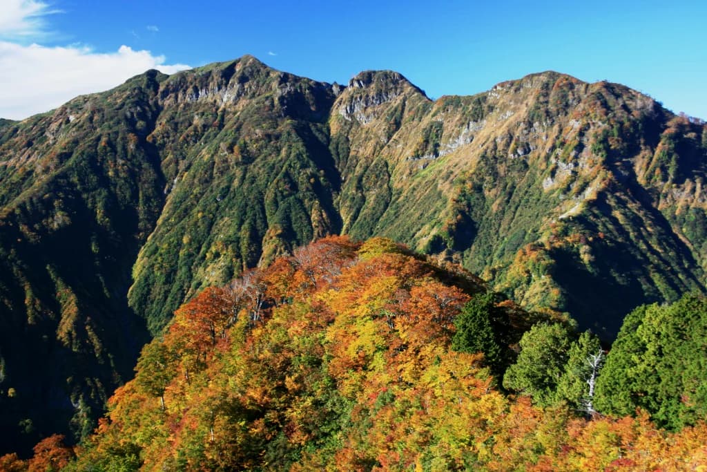
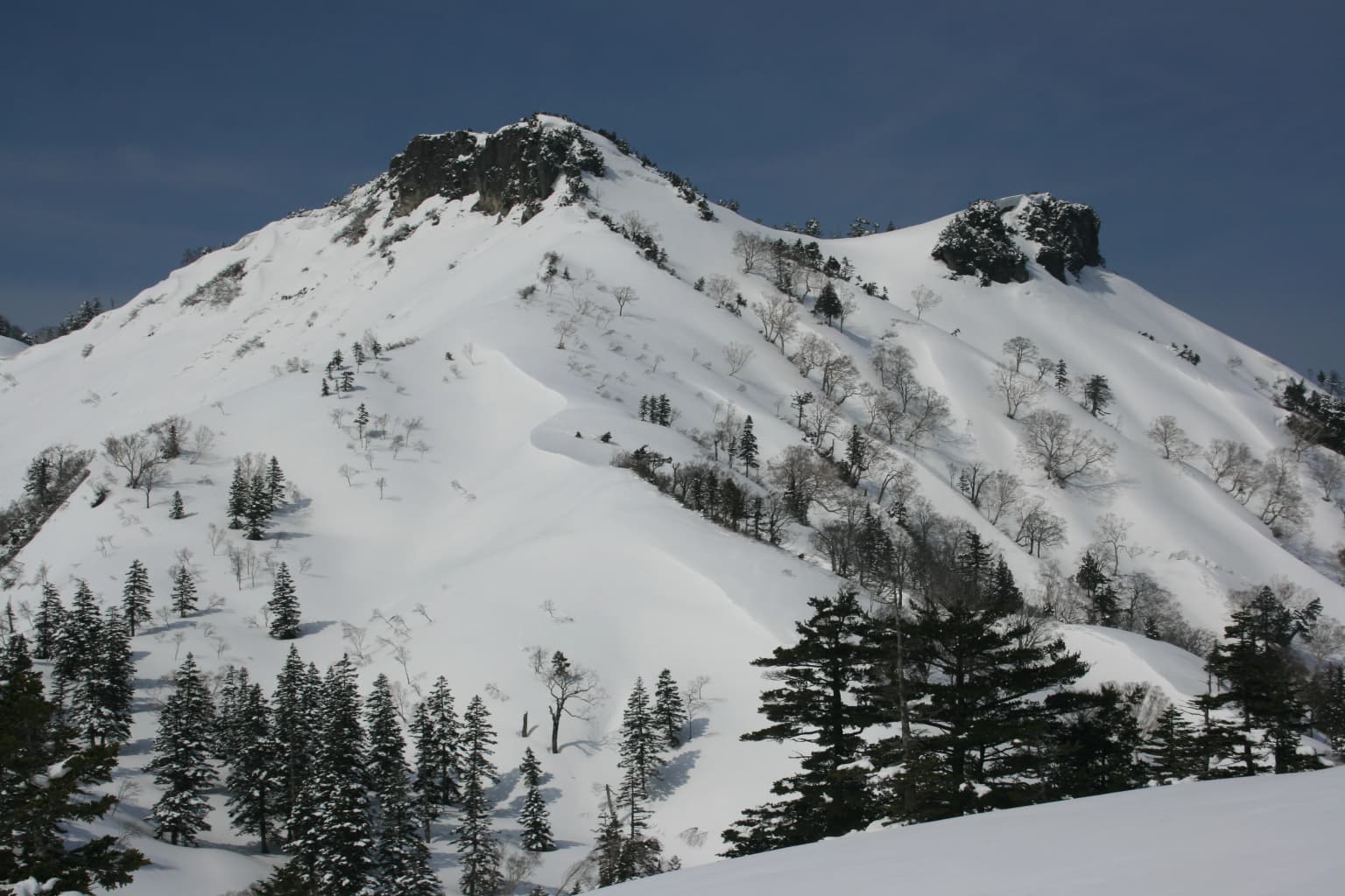
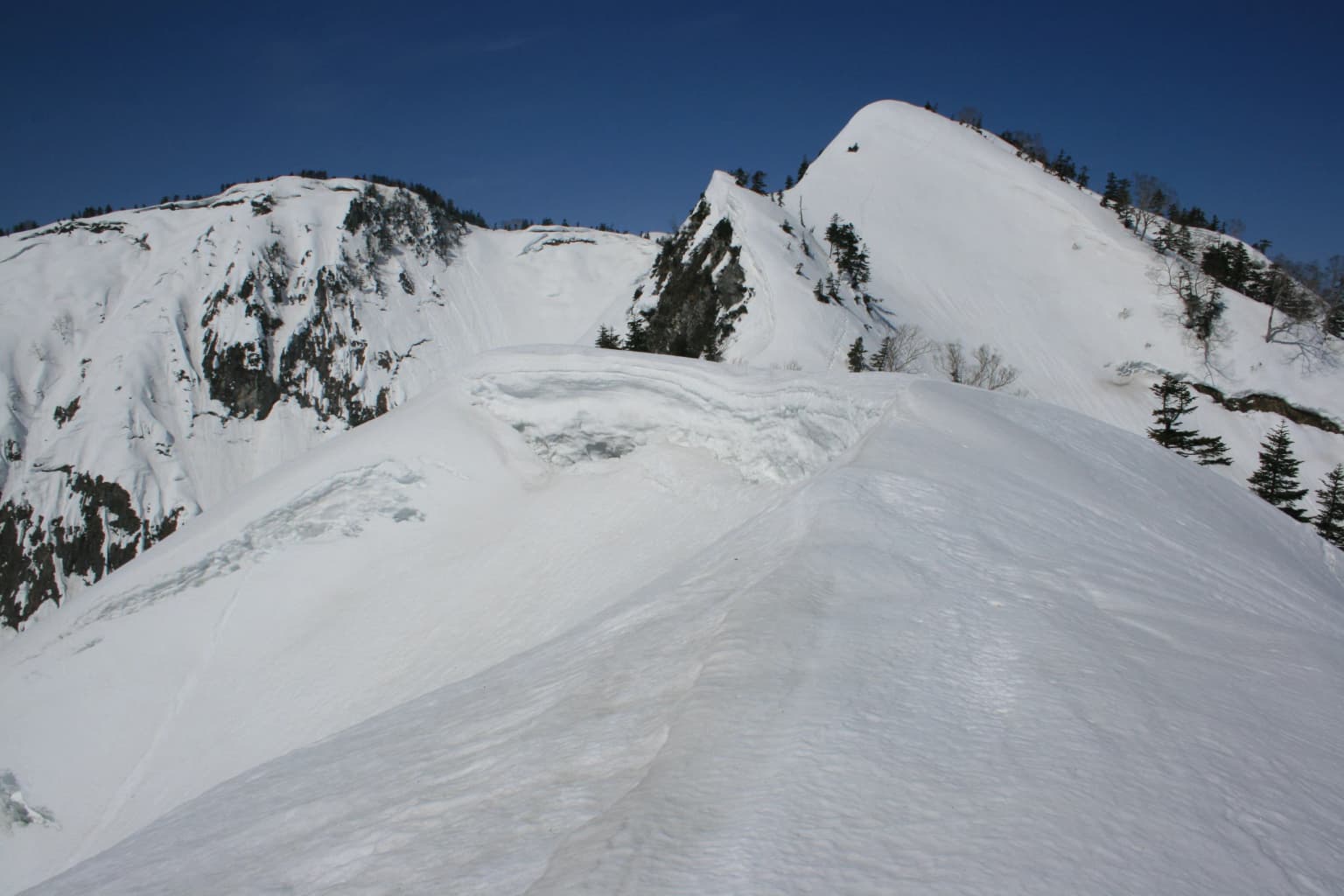
Best time to visit Hakusan National Park

The optimal time to visit Hakusan National Park depends on the experience sought, with each season offering distinct character. Summer months from July through September provide the most accessible hiking conditions, with the alpine flora at its peak from late June through August when snowmelt triggers successive blooming of alpine plants. The mountain hut season operates primarily during these months, and the Hakusan White Road typically opens from late April or early May through November, though specific dates vary by year and road conditions. Autumn in September and October offers spectacular fall foliage in the deciduous forests and clearer mountain visibility, though early snow may close higher trails by late October. Winter access is limited due to heavy snowfall exceeding several meters, and most facilities close from November through May. Spring provides a short season of snowmelt and emerging vegetation, though conditions can be unstable. The heavy snow climate means that even summer visits should prepare for sudden weather changes at higher elevations.

Park location guide

Geography guide, regional context, and park location map for Hakusan National Park

Hakusan National Park park geography, regions, and map view in Japan
Understand where Hakusan National Park sits in Japan through a broader geographic reading of the surrounding landscape, nearby location context, and its mapped position within the national park landscape.

How Hakusan National Park fits into Japan

Japan is an island nation in East Asia comprising over 14,000 islands in the Pacific Ocean. The country operates as a unitary parliamentary constitutional monarchy with Emperor Naruhito as the reigning monarch and Prime Minister Sanae Takaichi leading the government. With a population of approximately 123 million, Japan is the world's 11th most populous country and a major economic power with one of the strongest militaries, though it has constitutionally renounced its right to declare war.

Wider geography shaping Hakusan National Park in Japan

Japan is an island nation in the Pacific Ocean, bordered to the west by the Sea of Japan and extending from the Sea of Okhotsk in the north to the East China Sea in the south. The Japanese archipelago lies off the northeast coast of the Asian mainland. Approximately 75% of Japan's terrain is mountainous and heavily forested, with agricultural land and urbanized populations concentrated along the eastern coastal plains. The country is divided into 47 administrative prefectures and eight traditional regions.

Map view of Hakusan National Park

Use this park location map to pinpoint Hakusan National Park in Japan, understand its exact geographic position, and read its mapped placement within the surrounding landscape more clearly.

Pigeon | © OpenStreetMap contributors

Location context for Hakusan National Park

Chūbu regionFukui PrefectureGifu PrefectureIshikawa PrefectureToyama Prefecture

See the protected landscapes, from high alpine zones to old-growth beech forests, shaping this sacred Japanese mountain park.

Hakusan National Park Scenery: Explore Mountain Landscapes and Alpine Views
Browse a visual collection showcasing the unique landscapes and diverse habitats of Hakusan National Park, including the sacred Mount Haku, its alpine zones, volcanic lakes, and old-growth forests. These images provide essential context for understanding the park's distinct protected-area environment, from rugged mountain terrain to cascading waterfalls, revealing its ecological and cultural significance.

Hakusan National Park - Midagahara to Murododaira

Bessan viewed from Sannomine

Capricornis crispus on Mt. Sanpoiwa

Dainichigatake from Nobusegatake

Hakusan National Park Alpine Flowers 2009

Hakusan panorama

Hakusui lake and Mount Bessan

Mount Akausagi from Mount Nobuse

Mount Haku from Okusanpo 2011-04-10.jpg

Mount Haku from Onanjimine

Mount Hakusansyaka.jpg

Mount Nara and Mount Ogasa

Mount Sanpokuzure

Nanryu hut on Mount Haku

Ogasayama from Maeoizurugatake 2010-10-17.jpg

Oizurugatake from Maeoizurugatake

Park atlas

Browse mapped protected landscapes and mountain parks across the Ryōhaku Mountains and central Honshū.

Discover Other National Parks and Protected Areas Near Hakusan National Park in Japan's Chūbu Region
Continue exploring national parks and protected areas closely related to Hakusan National Park, tracing the geographic spread of Japan's prominent mountain landscapes and alpine ecosystems across the Chūbu region. Discover and compare other protected sites, from volcanic terrain to old-growth forests and significant waterfalls, gaining broader insight into regional conservation geography.
National parkChūbu region

Minami Alps National Park: A Protected Alpine Wilderness in Japan's Chūbu Region

Discover its dramatic peaks and vital river headwaters.

Minami Alps National Park offers a profound exploration into Japan's high-altitude natural geography. As a national park, it preserves a dramatic alpine environment defined by glacially carved terrain and multiple peaks exceeding 3000 meters. This protected landscape serves as a vital watershed, safeguarding the origins of major river systems and showcasing a rugged mountain character distinct from more accessible areas, ideal for understanding protected wildlands.

Area
357.52 km²
Established
1964
IUCN
II
National parkKantō region

Oze National Park National Park: A Key Protected Landscape in the Kantō Region

Explore its mapped geography and protected area context.

Oze National Park is a designated national park in Japan's Kantō region, offering a prime example of a protected landscape. This page provides detailed insights into its geographic setting and mapped boundaries, contributing to a structured understanding of regional natural terrain. Users can delve into the park's specific identity as a conservation area and its significance within the broader atlas of Japanese geography and protected lands.

Area
372.22 km²
Established
2007
IUCN
V
National parkJapan

Fuji-Hakone-Izu National Park: Japan's Premier National Park with Diverse Volcanic Landscapes and Mapped Geography

Explore volcanic terrain, hot springs, islands, and Mount Fuji's iconic protected boundaries.

Fuji-Hakone-Izu National Park is a vast and diverse protected area in Japan, anchored by the iconic Mount Fuji. This national park features a remarkable range of volcanic landscapes, including natural hot springs, rugged coastlines, and the unique Izu Islands extending into the Pacific. Delve into its mapped geography and protected landscape identity for a comprehensive atlas-style understanding of this significant natural asset within Japan.

Area
1,227 km²
Established
1936
IUCN
II
National parkKansai

Yoshino-Kumano National Park: Protected National Park with Sacred Mountain Landscapes and Ancient Routes

Explore mapped park boundaries, gorges, and pilgrimage routes in Kansai.

Yoshino-Kumano National Park, a significant national park in Japan's Kansai region, invites exploration of its protected landscapes, which are deeply intertwined with spiritual heritage. Discover the park's rugged mountain terrain, ancient cypress and cedar forests, dramatic gorges like Dorokyō Gorge, and iconic coastal areas. This park is a vital entry for understanding Japan's confluence of natural geography and cultural pilgrimage, offering rich context for mapped landscape discovery.

Area
616.04 km²
Established
1936
IUCN
II
National parkJapan

Setonaikai National Park: Japan's Premier Island Archipelago and Coastal Protected Landscape

Explore the unique marine geography and mapped island environments.

Setonaikai National Park is Japan's largest national park, renowned for its stunning marine environment within the Seto Inland Sea. This protected area features approximately 3,000 islands, showcasing weathered granite formations, coastal forests, and dynamic tidal phenomena like the Naruto whirlpools. The park offers a unique atlas-style exploration of island geography, coastal landscapes, and significant cultural sites, making it a cornerstone of Japan's protected natural heritage.

Area
669.34 km²
Established
1934
IUCN
II
National parkJapan

Towada-Hachimantai National Park: Mapping Japan's Volcanic and Alpine Protected Landscapes

Explore the geography of this northern Honshu national park.

Towada-Hachimantai National Park offers a unique atlas perspective on Japan's dynamic volcanic geology and alpine ecosystems. This national park protects a vast expanse of rugged terrain, featuring the iconic caldera of Lake Towada and the expansive volcanic plateaus of the Hachimantai region. Understanding its mapped boundaries reveals the distribution of its characteristic landscapes, from old-growth beech forests along river valleys to subalpine environments crowning volcanic peaks, providing a deep dive into its protected natural geography.

Area
855.34 km²
Established
1936
IUCN
II
National parkSouth Korea

Juwangsan National Park: Protected Mountain Landscape and Regional Geography in South Korea

Mapped terrain, park boundaries, and natural landscapes.

Juwangsan National Park is a protected natural area situated within South Korea's Taebaek mountain range, renowned for its steep valleys, waterfalls, and dense forests. This park offers a rich landscape context, showcasing dramatic ridgelines and providing a significant example of South Korea's protected mountain terrain. Discover its geographic placement, mapped protected boundaries, and the unique natural and cultural elements that define this national park.

Area
107.42 km²
Established
1976
IUCN
II
National parkNagasaki Prefecture

Unzen-Amakusa National Park: Volcanic Terrain and Island Geography

Explore Nagasaki Prefecture's Protected Landscape

Unzen-Amakusa National Park represents a significant protected area within Japan's geography, characterized by the imposing presence of Mount Unzen and the distinct maritime environment of the Amakusa islands. This national park offers an opportunity to study volcanic landscapes, coastal formations, and the rich cultural history intertwined with its natural setting. Understanding its mapped boundaries and geographic context provides valuable insight into Japan's protected lands and regional landscape diversity.

Area
282.79 km²
Established
1934
IUCN
II

Common questions about visiting, size, designation, and location context for Hakusan National Park

Hakusan National Park FAQs for park facts, access, geography, and protected area context
Find quick answers about Hakusan National Park, including protected-area facts, park geography, trail and visitor context, and how the park fits into its surrounding country and regional landscape.
MoriAtlas Explorer

Continue Your Protected Areas Search Across the Global Atlas

Deepen your exploration by continuing the structured search for national parks and protected areas worldwide. Utilize the comprehensive filtering capabilities to compare different conservation landscapes and refine your understanding of global park geography. Discover more about the distribution and characteristics of protected natural areas.

Global natural geography