Mori Atlas logo
National parkBirgonj National Park

Discover the mapped boundaries and ecological character of this key protected area in northern Bangladesh.

Birgonj National Park: Protected Sal Forest Landscape and Geographic Context in Dinajpur District

Birgonj National Park represents a vital protected sal forest ecosystem situated within the Dinajpur District of northern Bangladesh. Covering 168.56 hectares, this National Park, established in 2011, offers a unique opportunity to explore a landscape dominated by the ecologically significant Shorea robusta tree. Its status as a protected area emphasizes habitat conservation and provides a distinct natural contrast to the surrounding agricultural terrain, making it a key point for understanding regional protected land distribution and mapped forest ecosystems.

national parksal forestprotected areadeciduous forestBangladeshIUCN Category IV

Birgonj National Park

National park

Park overview

Structured park overview, official facts, and landscape profile for Birgonj National Park

Birgonj National Park park facts, protected area profile, and essential visitor context
Review the core facts for Birgonj National Park, including designation, size, terrain, visitor scale, habitats, and operating context in one park-focused overview.

About Birgonj National Park

Birgonj National Park serves as a protected forest area in the northwestern region of Bangladesh, representing the country's commitment to preserving native forest ecosystems outside of its more famous Sundarbans mangrove system. The park is located in an area characterized by agricultural land and rural settlements, making the protected forest corridor particularly important for maintaining biodiversity in a modified landscape. The dominance of sal trees creates a distinctive forest structure typical of the sal-bearing forests found across the Bengal region. The park's establishment in 2011 reflects Bangladesh's ongoing efforts to expand its protected area network and meet conservation targets for forest coverage. Management responsibility rests with the Bangladesh Forest Department through its Thakurgaon Forest Range administrative structure.

Quick facts and research context for Birgonj National Park

Birgonj National Park spans 168.56 hectares (417 acres) in the Birganj Upazila of Dinajpur District, situated in the northwestern part of Bangladesh. The protected area was formally declared on 14 December 2011 and is managed under the jurisdiction of the Thakurgaon Forest Range of the Bangladesh Forest Department. The park is classified as an IUCN Category IV protected area, denoting its function as a habitat and species management area. Its location along the Dhaka-Rangpur Highway provides regional accessibility while maintaining forest protection.

Park context

Deeper park guide and search-rich context for Birgonj National Park

Birgonj National Park history, landscape, wildlife, and travel context
Explore Birgonj National Park through its history, landscape character, ecosystems, wildlife, conservation priorities, cultural context, and seasonal travel timing in a structured park guide built for atlas discovery and search intent.

Why Birgonj National Park stands out

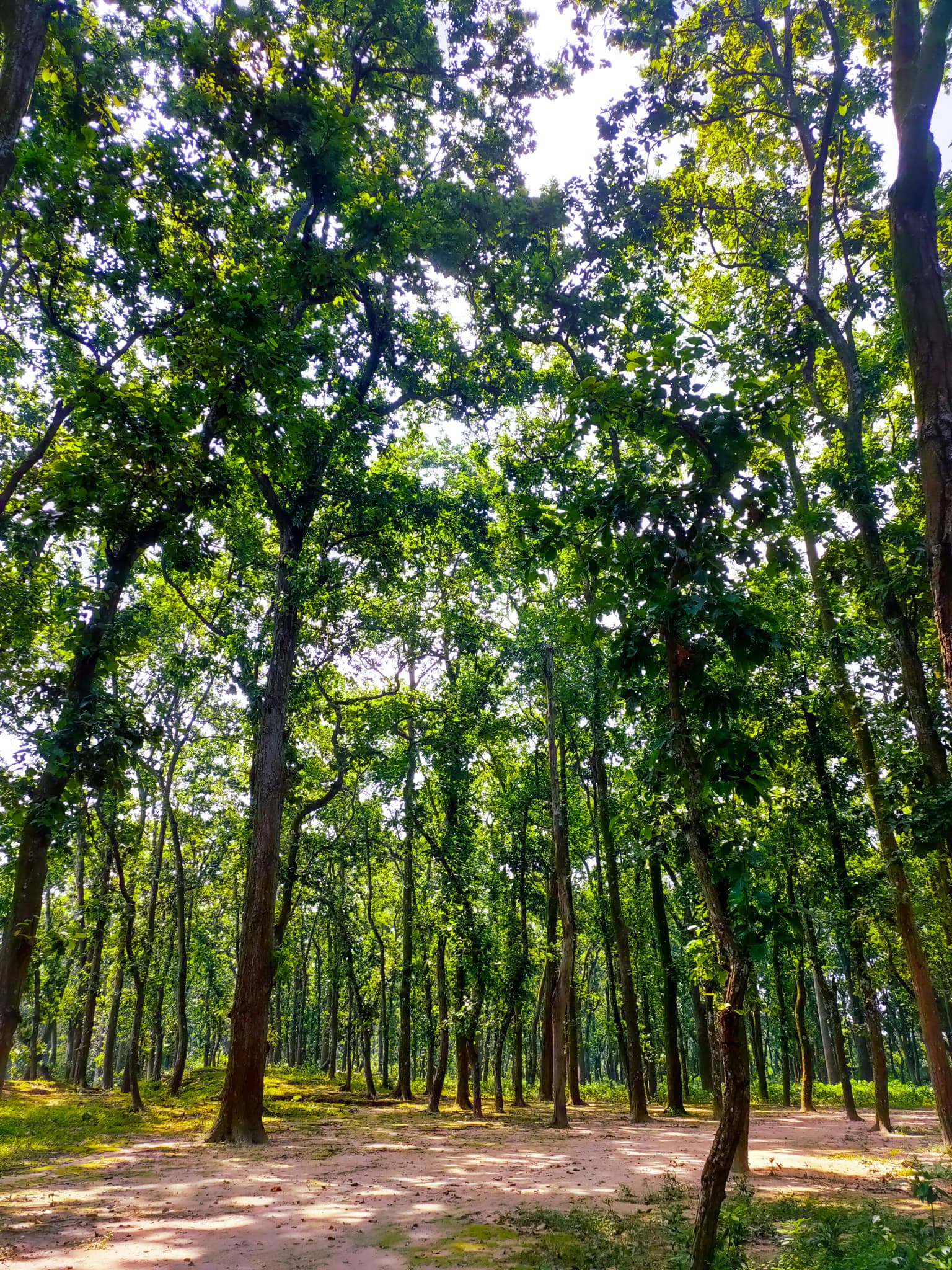
Birgonj National Park is best known for its extensive sal tree forest, which dominates the landscape and defines the ecological character of the protected area. Sal (Shorea robusta) is one of the most commercially and ecologically significant tree species in South Asia, and the park represents a protected example of this deciduous forest type in Bangladesh. The park's designation as an IUCN Category IV protected area emphasizes its conservation focus on maintaining viable habitat for species associated with sal forest ecosystems.

Birgonj National Park.jpg
Photo of a natural heritage site in Bangladesh.

Birgonj National Park history and protected-area timeline

Birgonj National Park was officially declared as a protected national park by the Government of Bangladesh on 14 December 2011. This relatively recent establishment places the park among the newer protected areas in Bangladesh's conservation portfolio. The creation of the park formalizes protection for the sal forest area that existed prior to its designation, transforming it from a general forest area into a legally protected national park with specific conservation mandates. The park falls within the Birgonj forest beat, an administrative division within the Thakurgaon Forest Range system managed by the Bangladesh Forest Department.

Birgonj National Park landscape and geographic character

The landscape of Birgonj National Park is characterized by deciduous forest dominated by sal trees, creating a relatively homogeneous forest canopy across its 168.56-hectare extent. The terrain is typical of the Dinajpur region, which consists largely of flat to gently undulating plains. The sal forest creates a structured habitat with taller canopy trees and varying understory density depending on seasonal conditions. This forest type contrasts with the surrounding agricultural landscape, forming a distinct green corridor in a region dominated by cultivated land.

Birgonj National Park ecosystems, habitats, and plant life

The ecological character of Birgonj National Park is defined by its sal forest ecosystem, which represents a major forest type across the Indian subcontinent. Sal (Shorea robusta) is a large deciduous tree species that forms nearly pure stands in favorable locations, creating a distinctive forest community. This forest type typically supports a range of associated plant species and provides habitat for various woodland organisms. The protected area serves as a remnant forest patch in a region where natural forest cover has been reduced by agricultural expansion.

Birgonj National Park wildlife and species highlights

The sal forest habitat of Birgonj National Park supports wildlife typical of deciduous forest areas in Bangladesh. Sal forests across the region are known to host various bird species, small mammals, and reptiles adapted to woodland environments. While the source material does not provide detailed species lists, the protected forest area provides habitat continuity for forest-dwelling species in a region where natural forest has been largely converted to agricultural use.

Birgonj National Park conservation status and protection priorities

Birgonj National Park is classified as an IUCN Category IV protected area, which designates it as a habitat or species management area. This category indicates active management interventions aimed at maintaining specific habitats or supporting particular species populations. The park contributes to Bangladesh's national conservation targets by preserving a forest type that has faced significant reduction across the country. The protected status provides legal framework for forest protection and prevents conversion to agricultural or other uses.

Birgonj National Park cultural meaning and human context

The park is located in Birganj Upazila, a region with historical significance in the northwestern part of Bangladesh. The area has been part of the broader Dinajpur region, which contains various archaeological and historical sites. The local population includes communities engaged in agriculture and related activities. The establishment of the protected area reflects a balance between local land use patterns and conservation objectives.

Top sights and standout views in Birgonj National Park

The park's primary distinction lies in its role as a protected sal forest in northern Bangladesh, representing a forest type that has become increasingly rare in the country. The protected area provides ecological services including habitat for forest species, watershed protection, and carbon sequestration. Its proximity to the Dhaka-Rangpur Highway makes it accessible for environmental education and nature observation. The 2011 establishment date marks it as a relatively recent addition to Bangladesh's national park system.

Best time to visit Birgonj National Park

The best time to visit Birgonj National Park would likely coincide with the cooler winter months from November through February, which is the general optimal season for visiting protected areas in Bangladesh. During this period, weather conditions are more comfortable for outdoor exploration and wildlife activity patterns may be more observable. The monsoon season from June to September brings rainfall to the region and would likely affect accessibility and visitor comfort.

Park location guide

Geography guide, regional context, and park location map for Birgonj National Park

Birgonj National Park park geography, regions, and map view in Dinajpur District
Understand where Birgonj National Park sits in Dinajpur District through a broader geographic reading of the surrounding landscape, nearby location context, and its mapped position within the national park landscape.

Map view of Birgonj National Park

Use this park location map to pinpoint Birgonj National Park in Dinajpur District, understand its exact geographic position, and read its mapped placement within the surrounding landscape more clearly.

Pigeon | © OpenStreetMap contributors

Visually understand the distinctive sal tree forest environment and the ecological character of this Bangladesh protected area.

Birgonj National Park Photos: Explore Landscapes, Scenery, and Protected Forest Habitats
View high-quality Birgonj National Park images to visually grasp its dominant sal forest landscape and the characteristic terrain of this protected deciduous ecosystem. These photographs provide essential insights into the park's unique habitat structure, offering a deeper understanding of its conservation value within the Dinajpur region of Bangladesh.

Birgonj National Park.jpg

Park atlas

Trace the regional spread of national parks and conservation landscapes across northern Bangladesh.

Discover More Protected Areas Near Birgonj National Park and Surrounding Landscapes
Continue your atlas exploration by browsing other national parks and protected areas located geographically near Birgonj National Park in northern Bangladesh. Compare diverse conservation landscapes, understand regional protected area distribution, and identify distinct forest ecosystems within the broader Dinajpur District.
National parkBangladesh

Singra National Park: Bangladesh National Park Atlas and Protected Landscape Context

Mapped geographic identity of a protected national park.

Singra National Park is a significant protected area in Bangladesh, identified as a national park. This platform facilitates an atlas-style exploration of its geographic placement and protected landscape characteristics. Users can discover its mapped boundaries and understand its context within the regional geography of South Asia, contributing to a comprehensive understanding of national park significance.

Area
3.057 km²
Established
2010
Relief
Lowland
Climate
Tropical
National parkDinajpur District

Ramsagar National Park: National Park Protected Area & Geographic Discovery

Explore mapped boundaries and regional landscape context.

Understand Ramsagar National Park as a protected national park within Dinajpur District, Bangladesh. This detail entry provides essential geographic context, outlining the park's mapped protected boundaries and its significance within the regional landscape. It serves as a foundational point for exploring the park's specific natural terrain and its place in a global atlas of conservation lands.

Area
0.278 km²
Established
2001
IUCN
IV
Relief
Lowland
National parkDinajpur District

Dharmapur National Park: Sal Forest Ecosystem and Protected Landscape in Dinajpur District

Mapped geography and birdwatching habitats within northern Bangladesh.

Dharmapur National Park, designated as a national park in Dinajpur District, northern Bangladesh, spans 704.70 hectares across 21 revenue villages. It is characterized by dense Sal forests, a distinctive ecosystem forming the ecological core of the protected area. The landscape features semi-deciduous forest terrain, shaped by the Bijra and Nona rivers, offering riparian zones within its relatively flat geography. This protected forest serves as a significant habitat for numerous bird species and mammals, making it a key point of interest for understanding the region's natural landscape and conservation efforts. Explore its mapped boundaries and geographic significance.

Area
7.047 km²
Established
2021
Relief
Lowland
Climate
Tropical
National parkBangladesh

Nawabganj National Park: Bangladesh National Park Geographic Identity and Atlas Exploration

Mapped boundaries and protected landscape context.

Delve into the detailed geographic profile of Nawabganj National Park, a protected national park located in Bangladesh. This resource facilitates an atlas-style discovery of its specific mapped boundaries and its contribution to the region's natural landscape character. Understand how this protected area fits within the broader context of South Asian geography and conservation.

Area
5.176 km²
Established
2010
IUCN
IV
Access
Easy access
National parkNaogaon District

Altadighi National Park: Bangladesh's Protected Wetland Reserve in Naogaon District

Explore its mapped terrain and unique wetland ecosystem.

Altadighi National Park in Naogaon District, Bangladesh, is a protected nature reserve notable for its significant reservoir and wetland environment. Designated as a national park, it plays a crucial role in conserving a distinctive ecosystem within the country's protected landscape network. The park's geography, centered around its large water body, provides vital habitat and offers a unique subject for geographic and atlas-based discovery in northern Bangladesh, distinguishing it from more terrestrial protected areas.

Area
2.641 km²
Established
2011
IUCN
IV
Relief
Lowland
National parkJalpaiguri district

Gorumara National Park: India National Park Atlas and Protected Landscape Geography

Discover the mapped boundaries and regional terrain.

Gorumara National Park stands as a vital protected natural area within India's Jalpaiguri district. This entry provides detailed atlas-focused information, detailing the park's geographic identity and its position within the regional landscape context. Understand the mapped protected boundaries and explore the unique terrain that characterizes Gorumara National Park as a key national park entity. It serves as a foundational point for geographic discovery within India's network of protected lands.

Area
79.99 km²
Established
1992
IUCN
II
Relief
Mixed relief
National parkAlipurduar district

Jaldapara National Park: India's Premier Grassland and Rhino Conservation Landscape

Explore mapped boundaries and savanna terrain in Alipurduar district.

Jaldapara National Park is a protected national park in India's Alipurduar district, celebrated for its expansive rolling grasslands and significant population of Indian one-horned rhinoceros. This protected area showcases a distinctive savanna landscape, an unusual feature among Indian national parks, interspersed with riverine forests. Its elevation of 61 meters above sea level positions it at the edge of the Eastern Himalayas, offering a unique geographic setting for understanding regional biodiversity and conservation efforts.

Area
216.51 km²
Established
1941
IUCN
II
Relief
Lowland
National parkKalimpong district

Neora Valley National Park: India's Protected Landscape in Kalimpong District

Explore mapped boundaries and regional geography.

Neora Valley National Park is a significant protected area designated as a national park in India, located within the Kalimpong district. This dedicated page provides detailed geographic information, focusing on its mapped boundaries and its role as a natural landscape within the region. Understand the specific protected-area context of Neora Valley National Park for atlas-based discovery.

Area
88 km²
Established
1986
IUCN
II
Relief
Mountain

Common questions about visiting, size, designation, and location context for Birgonj National Park

Birgonj National Park FAQs for park facts, access, geography, and protected area context
Find quick answers about Birgonj National Park, including protected-area facts, park geography, trail and visitor context, and how the park fits into its surrounding country and regional landscape.
MoriAtlas Explorer

Continue Your Protected Areas Search Across the Global Atlas

Deepen your exploration by continuing the structured search for national parks and protected areas worldwide. Utilize the comprehensive filtering capabilities to compare different conservation landscapes and refine your understanding of global park geography. Discover more about the distribution and characteristics of protected natural areas.

Global natural geography