Mori Atlas logo
National parkGorumara National Park

Mapping the protected boundaries and regional context of Gorumara National Park.

Gorumara National Park: India's National Park Geography and Protected Landscape Atlas

(Gorumara Jatio Uddan)

Gorumara National Park represents a significant protected area within the geographic landscape of India's Jalpaiguri district. This detail page serves as an authoritative entry point for understanding its role as a national park, offering insights into its mapped boundaries, regional setting, and overall contribution to a structured atlas of natural landscapes. Users can explore the unique geographic context that defines Gorumara National Park and its place within the broader map of protected territories in the region.

Indian RhinocerosTerai GrasslandsRiverine ForestsEastern HimalayasDooars RegionBirdwatching

Gorumara National Park

National park

Park overview

Structured park overview, official facts, and landscape profile for Gorumara National Park

Gorumara National Park park facts, protected area profile, and essential visitor context
Review the core facts for Gorumara National Park, including designation, size, terrain, visitor scale, habitats, and operating context in one park-focused overview.

About Gorumara National Park

Gorumara National Park represents one of the most important conservation landscapes in the Indian subcontinent, protecting a vital remnant of the once-extensive Terai grasslands that stretched along the Himalayan foothills from Bhutan to Uttar Pradesh. Located in the Dooars region of West Bengal, the park encompasses a diverse mix of habitats ranging from dense sal forests to open grasslands and riverine wetlands that have evolved over millennia in the flood plains of the Murti and Raidak rivers. The park's position at the confluence of the Ganges and Brahmaputra watersheds gives it ecological significance beyond its relatively modest area, serving as a corridor for wildlife movement between India and Bhutan. Originally established as a small 7 square kilometer reserve, Gorumara has grown through the incorporation of neighboring lands to its current extent of approximately 80 square kilometers, reflecting a conservation model that has successfully integrated local communities into protection efforts. The park today operates as a showcase of community-based conservation, with more than 10,000 resident forest villagers deriving livelihoods from ecotourism and forest department employment, creating a stakeholder base invested in the park's long-term protection.

Quick facts and research context for Gorumara National Park

Gorumara National Park covers 79.99 square kilometers in the Eastern Himalayas' submontane Terai belt. The park was formally designated as a national park on January 31, 1992, having previously operated as a wildlife sanctuary since 1949 and a reserved forest since 1895. It is classified as an IUCN Category II protected area. The climate varies significantly across seasons, with winter temperatures dropping to 10°C, summer highs reaching 37°C, and an average annual rainfall of 382 centimeters concentrated between mid-May and mid-October. The park is located near the towns of Lataguri and Ramsai, with the nearest major railhead at New Maynaguri approximately 18 kilometers away.

Park context

Deeper park guide and search-rich context for Gorumara National Park

Gorumara National Park history, landscape, wildlife, and travel context
Explore Gorumara National Park through its history, landscape character, ecosystems, wildlife, conservation priorities, cultural context, and seasonal travel timing in a structured park guide built for atlas discovery and search intent.

Why Gorumara National Park stands out

Gorumara National Park is primarily celebrated for its significant population of Indian rhinoceros, one of the rare great one-horned rhinoceros survivors in India. The park was recognized as the best protected area in India by the Ministry of Environment and Forests in 2009, a distinction reflecting its successful conservation outcomes. Beyond rhinoceros, the park is known for its diverse Terai ecosystem combining grasslands, riverine forests, and sal woodlands that support a remarkable concentration of large herbivores including gaur, Asian elephant, sloth bear, chital, and sambar deer. The park's multiple watchtowers, particularly Jatraprasad and Medla towers, offer visitors exceptional wildlife viewing opportunities in a landscape that remains one of the few remaining intact Terai grasslands in the subcontinent.

Gorumara National Park history and protected-area timeline

Gorumara's journey from colonial reserve to modern national park spans more than a century of changing conservation philosophy in India. The area was first declared a reserved forest in 1895 during the British Raj, recognizing its value as a timber resource and wildlife habitat. In 1949, following India's independence, the area was redesignated as a wildlife sanctuary specifically to protect its breeding population of Indian rhinoceros, which had been severely depleted by hunting during the colonial period. The transformation from sanctuary to national park came on January 31, 1992, elevating the protection status and bringing additional resources for management and development. The park's forest bungalow, dating to the British era, remains standing and contains historical log books documenting the evolution of wildlife management in the region. The park achieved national recognition in 2009 when the Ministry of Environment and Forests declared it the best protected area in India, a testament to the effectiveness of its management approach combining ecological protection with community engagement.

Gorumara National Park landscape and geographic character

The physical landscape of Gorumara National Park is defined by its position in the submontane Terai belt of the Eastern Himalayas, a region of flat to gently rolling terrain interspersed with river channels and wetlands that extends along the Himalayan foothills. The park sits on the flood plains of the Murti River and Raidak River, with the Jaldhaka River, a tributary of the Brahmaputra system, serving as the major watercourse flowing through the area. The terrain is characteristically flat to undulating, with elevations typical of the Terai at around 100 to 300 meters above sea level. The landscape supports a mosaic of vegetation types, with extensive grasslands dominating the riverine zones and dense sal forest covering the higher ground. The combination of fertile alluvial soils, abundant water resources, and strategic location between the mountains and the plains has created a uniquely productive ecosystem that supports exceptional biodiversity.

Gorumara National Park ecosystems, habitats, and plant life

Gorumara National Park encompasses two primary ecoregions that together represent the characteristic Terai-Duar ecosystem of the Himalayan foothills. The Terai-Duar savanna and grasslands form the dominant habitat type, representing the tropical and subtropical grasslands biome that once covered vast stretches of the Himalayan alluvial plains. The Lower Gangetic Plains moist deciduous forests occupy the higher terrain within the park, characterized by sal as the dominant tree species alongside common teak, rain tree, and bombax. Bamboo groves are widespread throughout the understory, while tropical riverine reeds dominate the wetland edges. The park is notably rich in orchid diversity, with numerous tropical orchid species found throughout the forest and grassland habitats. This combination of grassland and forest ecosystems creates the heterogeneous landscape that supports the park's extraordinary concentration of large herbivores and represents one of the most intact examples of Terai ecology remaining in India.

Gorumara National Park wildlife and species highlights

The wildlife community of Gorumara National Park represents one of the most impressive assemblages of large mammals in eastern India, with the park recording fifty species of mammals, 194 species of birds, twenty-two species of reptiles, seven species of turtles, and twenty-seven species of fish. The flagship species is the Indian rhinoceros, for which the park was originally protected and which remains the primary conservation focus. Large herbivores are exceptionally abundant, with populations of gaur, Asian elephant, sloth bear, chital, and sambar deer regularly observed from the park's numerous watchtowers. Smaller herbivores include barking deer, hog deer, and wild boar, while the carnivore community is notable for the relative absence of large predators, with leopards being the only big cat present and no resident populations of tigers, wild dogs, or wolves. The park has recorded several endangered species including the critically endangered pygmy hog and the rare hispid hare, alongside populations of giant squirrels. The bird community includes notable species such as the great Indian hornbill, numerous woodpeckers and pheasants, and migratory birds including the rare brahminy duck that passes through the park on established flyways. Reptiles include both venomous and non-venomous species, with the Indian python and king cobra among the notable inhabitants.

Gorumara National Park conservation status and protection priorities

Conservation at Gorumara National Park centers on maintaining a viable breeding population of Indian rhinoceros, the species that motivated the original protected area designation in 1949. The park has achieved notable success in rhino conservation, though this success has created new challenges including demographic imbalances in the rhinoceros population, with male-to-female ratios reaching concerning levels due to the lack of natural predation pressure. Similarly, the gaur population has doubled in recent years, creating risks of overgrazing and habitat degradation. Poaching was a severe threat in the 1970s and 1980s but has been largely controlled through improved ranger equipment and community engagement that ensures local villagers benefit from tourism revenue. Remaining challenges include grazing pressure from fringe villages and periodic man-made brush fires, while a particularly concerning contemporary issue involves train collisions with elephants on railway lines traversing the park's boundaries, a problem that Indian Railways and park authorities are actively working to address through various mitigation measures.

Gorumara National Park cultural meaning and human context

Gorumara National Park is intimately connected with the surrounding ethnic villages that have inhabited the Dooars region for generations. More than 10,000 resident forest villagers live in communities adjacent to the park boundaries, deriving their livelihoods from employment in forest department activities, ecotourism, and traditional agricultural practices. Villages such as Sarswati, Budhuram, Bichabhanga, Chatua, Kailipur, and Murti Forest Village encircle the park and participate in community-based tourism initiatives that allow visitors to experience local culture and traditional lifestyles. The Budhuram Forest Village has developed a popular evening ethnic tribal dance demonstration that showcases the cultural heritage of the region's indigenous communities. This integration of local communities into the park's management and economy represents a conservation model that recognizes the historical human presence in the landscape and seeks to align community interests with protection objectives.

Top sights and standout views in Gorumara National Park

Gorumara National Park offers exceptional wildlife viewing opportunities from its network of strategically positioned watchtowers, with the Jatraprasad Watch Tower, Rhino Observation Point, Chandrachur Watch Tower, Chukchuki Bird-watching Point, and Medla Watch Tower each providing access to different habitats and wildlife concentrations. The park is one of the few remaining strongholds of the Indian rhinoceros in India and offers visitors the chance to observe these massive animals from close range, particularly at the Rhino Observation Point near the forest bungalow. The Medla Watch Tower provides panoramic views of the surrounding landscape, while the Chukchuki area is particularly popular among birdwatchers for its diverse avifauna. Visitors can also explore nearby forest villages to experience the traditional culture of the Dooars region, with evening ethnic dance performances available at Budhuram Forest Village. The park's proximity to the Murti River allows for scenic walks along its banks, and the landscape is particularly attractive during the winter months when migratory birds arrive and the weather is comfortable for outdoor exploration.

Best time to visit Gorumara National Park

The optimal time to visit Gorumara National Park is from November through March, when temperatures range between 10 and 21 degrees Celsius and the weather remains dry and comfortable for wildlife viewing. This period coincides with the winter migration of birds and offers the best chances of observing rhinoceros and other large mammals at waterholes and in the open grasslands. The park is closed during the monsoon season from June 16 to September 15, when heavy rainfall makes the terrain difficult to traverse and wildlife viewing is limited. The months of November and December offer the added attraction of comfortable temperatures and clear visibility, while February and March continue to provide excellent conditions with the advantage of seeing newborn wildlife. The summer months from April through June can be extremely hot, with temperatures reaching 37 degrees Celsius, making midday wildlife viewing uncomfortable and less productive.
Park location guide

Geography guide, regional context, and park location map for Gorumara National Park

Gorumara National Park park geography, regions, and map view in India
Understand where Gorumara National Park sits in India through a broader geographic reading of the surrounding landscape, nearby location context, and its mapped position within the national park landscape.

How Gorumara National Park fits into India

India is a South Asian country bordered by the Indian Ocean, Arabian Sea, and Bay of Bengal. It shares land borders with Pakistan, China, Nepal, Bhutan, Bangladesh, and Myanmar. The country has a population of over 1.4 billion people and operates as a federal parliamentary republic with its capital in New Delhi.

Wider geography shaping Gorumara National Park in India

India occupies the Indian subcontinent in South Asia, bordered by the Arabian Sea to the southwest, the Bay of Bengal to the southeast, and the Indian Ocean to the south. It shares land borders with Pakistan to the west, China, Nepal, and Bhutan to the north, and Bangladesh and Myanmar to the east. The territory also includes the Andaman and Nicobar Islands in the Indian Ocean.

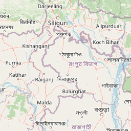
Map view of Gorumara National Park

Use this park location map to pinpoint Gorumara National Park in India, understand its exact geographic position, and read its mapped placement within the surrounding landscape more clearly.

Pigeon | © OpenStreetMap contributors

Location context for Gorumara National Park

Jalpaiguri districtWest Bengal
Park atlas

Compare surrounding protected areas and mapped park geography across India's Eastern Himalayan foothills.

Discover More Protected Areas and National Parks Near Gorumara National Park in the Eastern Himalayas
Expand your park discovery beyond Gorumara National Park by browsing other national parks and protected areas across the diverse Terai-Duar ecosystem. Compare the varied landscapes, conservation efforts, and regional park geography of protected natural areas in this ecologically significant part of India.
National parkKalimpong district

Neora Valley National Park: India's Protected Landscape in Kalimpong District

Explore mapped boundaries and regional geography.

Neora Valley National Park is a significant protected area designated as a national park in India, located within the Kalimpong district. This dedicated page provides detailed geographic information, focusing on its mapped boundaries and its role as a natural landscape within the region. Understand the specific protected-area context of Neora Valley National Park for atlas-based discovery.

Area
88 km²
Established
1986
IUCN
II
Relief
Mountain
National parkAlipurduar district

Jaldapara National Park: India's Premier Grassland and Rhino Conservation Landscape

Explore mapped boundaries and savanna terrain in Alipurduar district.

Jaldapara National Park is a protected national park in India's Alipurduar district, celebrated for its expansive rolling grasslands and significant population of Indian one-horned rhinoceros. This protected area showcases a distinctive savanna landscape, an unusual feature among Indian national parks, interspersed with riverine forests. Its elevation of 61 meters above sea level positions it at the edge of the Eastern Himalayas, offering a unique geographic setting for understanding regional biodiversity and conservation efforts.

Area
216.51 km²
Established
1941
IUCN
II
Relief
Lowland
National parkDarjeeling District

Singalila National Park: A High-Altitude Protected Landscape on the Eastern Himalayan Ridge

Explore mapped terrain and alpine park geography in Darjeeling District.

Singalila National Park represents a crucial protected natural landscape within the Eastern Himalayas, located in India's Darjeeling District. Defined by its dramatic ridgeline that ascends to over 4,000 meters, the park offers a unique alpine environment with stunning panoramic views. Its designation as a national park highlights its importance for conservation and its role in the regional geographic atlas. Discover the mapped boundaries and ecological context of this remarkable mountain wilderness, from its dense forests to its open alpine meadows.

Area
78.6 km²
Established
1986
IUCN
II
Relief
Mountain
National parkBangladesh

Singra National Park: Bangladesh National Park Atlas and Protected Landscape Context

Mapped geographic identity of a protected national park.

Singra National Park is a significant protected area in Bangladesh, identified as a national park. This platform facilitates an atlas-style exploration of its geographic placement and protected landscape characteristics. Users can discover its mapped boundaries and understand its context within the regional geography of South Asia, contributing to a comprehensive understanding of national park significance.

Area
3.057 km²
Established
2010
Relief
Lowland
Climate
Tropical
Watercolor illustration showing a landscape with grassy areas, trees, and distant mountains under a pinkish sky
National parkDinajpur District

Birgonj National Park: Protected Sal Forest Landscape in Dinajpur District, Bangladesh

Explore mapped boundaries and regional geographic context.

Birgonj National Park, located in Dinajpur District, offers a focused exploration of a protected sal forest ecosystem. As a designated National Park in Bangladesh, it preserves a significant area of Shorea robusta forest, providing valuable insight into deciduous forest landscapes and their conservation. This park serves as a critical reference point for understanding protected areas within northern Bangladesh and their role in regional geographic context, making it an important destination for atlas-based discovery of natural landscapes.

Area
1.686 km²
Established
2011
IUCN
IV
Climate
Tropical
National parkSikkim

Khangchendzonga National Park: National Park in Sikkim with Mapped Boundaries

Explore protected landscapes and regional geography.

Understand Khangchendzonga National Park as a key protected area within Sikkim, India. This entry provides focused atlas information on the park's geographic features, mapped boundaries, and its role as a national park, offering essential context for regional landscape discovery and exploration.

Area
1,784 km²
Established
1977
IUCN
II
Relief
Mountain
National parkKokrajhar District

Raimona National Park: National Park Protected Landscape and Geographic Atlas Exploration

Discover mapped terrain and regional geography within Raimona National Park.

Raimona National Park, designated as a national park within India's Kokrajhar District, offers rich opportunities for atlas-based geographic discovery. This page details the park's protected landscape, providing insights into its mapped boundaries and the surrounding natural terrain. Understanding Raimona National Park's placement within the regional geography allows for a deeper appreciation of its role as a significant protected area, perfect for detailed map exploration and landscape context.

Area
422 km²
Established
2021
IUCN
II
Relief
Mountain
Wildlife reserveBhutan

Motithang Takin Preserve: Bhutan Wildlife Reserve with Unique Protected Landscape Context

Explore the mapped geography and national animal sanctuary.

The Motithang Takin Preserve offers a unique glimpse into Bhutan's dedication to its national animal, the takin. This wildlife reserve, located near the capital city, provides a defined protected area where the distinctive goat-antelope thrives. By examining the preserve's mapped boundaries and its forested terrain, users gain insight into Bhutan's approach to conservation and the cultural significance of this iconic species within the Himalayan landscape.

Area
0.034 km²
IUCN
IV
Relief
Upland
Climate
Temperate

Common questions about visiting, size, designation, and location context for Gorumara National Park

Gorumara National Park FAQs for park facts, access, geography, and protected area context
Find quick answers about Gorumara National Park, including protected-area facts, park geography, trail and visitor context, and how the park fits into its surrounding country and regional landscape.
MoriAtlas Explorer

Continue Your Protected Areas Search Across the Global Atlas

Deepen your exploration by continuing the structured search for national parks and protected areas worldwide. Utilize the comprehensive filtering capabilities to compare different conservation landscapes and refine your understanding of global park geography. Discover more about the distribution and characteristics of protected natural areas.

Global natural geography