

Mori Atlas logo
National parkRaimona National Park

An atlas-focused exploration of Raimona National Park's mapped terrain and regional geography.

Raimona National Park: Exploring National Park Geography and Protected Landscape Boundaries

Raimona National Park stands as a vital protected landscape within India's Kokrajhar District, offering a unique focus for geographic exploration. This dedicated national park provides an essential node for understanding mapped park boundaries and the natural terrain it encompasses. As an integral part of the region's atlas, Raimona National Park serves as a key entry point for discovering the specific geographic context and protected area characteristics that define this natural landscape.

National ParkAssamHimalayan FoothillsElephant HabitatTiger Reserve BufferEndangered Primates

Raimona National Park

National park

Park overview

Structured park overview, official facts, and landscape profile for Raimona National Park

Raimona National Park park facts, protected area profile, and essential visitor context
Review the core facts for Raimona National Park, including designation, size, terrain, visitor scale, habitats, and operating context in one park-focused overview.

About Raimona National Park

Raimona National Park represents one of India's newer protected areas, established in 2021 to conserve a biologically rich stretch of Himalayan foothill forest in western Assam. The park occupies a strategic position at the interface between the Himalayan mountain system and the broader Brahmaputra valley ecosystem, creating a unique ecological transition zone. Its establishment followed decades of recommendations for protecting the area as a wildlife sanctuary, originally proposed as part of the Ripu-Chirang Wildlife Sanctuary due to its remarkable conservation value for elephants, gaur, and golden langur. The park connects to the larger Ripu Reserve Forest, forming a contiguous forest complex of over 500 square kilometers that provides essential habitat connectivity for wide-ranging species such as elephants and tigers moving between protected areas. This connectivity is particularly important as Raimona serves as the westernmost buffer to Manas Tiger Reserve, one of India's oldest and most significant tiger conservation landscapes. The Bodoland Territorial Region setting adds cultural dimension to the park's context, as local communities have historically interacted with these forest lands.

Quick facts and research context for Raimona National Park

Raimona National Park spans 422 square kilometers in western Assam, India, in the Himalayan foothills. It was officially designated as a national park on June 9, 2021, following a Chief Minister announcement on World Environment Day. The park is bounded by the Sankosh River to the west, the Saralbhanga River to the north and east, and adjoins the Ripu Reserve Forest to the south. Governed by the Government of Assam, it serves as a critical conservation corridor connecting the Manas Tiger Reserve ecosystem with surrounding forest tracts in the Eastern Himalayan region.

Park context

Deeper park guide and search-rich context for Raimona National Park

Raimona National Park history, landscape, wildlife, and travel context
Explore Raimona National Park through its history, landscape character, ecosystems, wildlife, conservation priorities, cultural context, and seasonal travel timing in a structured park guide built for atlas discovery and search intent.

Why Raimona National Park stands out

Raimona National Park is best known for its significant populations of Asian elephants, gaur (Indian bison), and the endemic golden langur, a primate species found almost exclusively in this region of Assam. The park also supports a remarkable diversity of large mammals including Bengal tigers, leopards, clouded leopards, and various deer species. Its location within the Eastern Himalaya Biodiversity Hotspot and role as a tiger reserve buffer contribute to its conservation significance. The park has been recognized as an Important Bird and Biodiversity Area, hosting species such as the white-bellied heron, Bengal florican, and numerous hornbill species.

Raimona National Park history and protected-area timeline

The conservation history of Raimona National Park spans several decades of recommendation and advocacy. The area was initially proposed for protection as the Ripu-Chirang Wildlife Sanctuary, encompassing portions of the Ripu Reserved Forest and Chirang Reserved Forest. This recommendation stemmed from the area's exceptional significance for conserving viable populations of Asian elephants, gaur (Indian bison), and the endangered golden langur, all of which maintain substantial populations in this portion of Assam. After years of consideration, Raimona was formally declared a national park on June 5, 2021, announced by the Chief Minister of Assam at Gandhi Mandap in Guwahati on World Environment Day. The formal notification followed in the Assam Gazette on June 9, 2021. The park was carved from the northern portion of the notified Ripu Reserve Forest, creating a dedicated protected area that had long been recommended for higher conservation status.

Raimona National Park landscape and geographic character

Raimona National Park occupies the Himalayan foothill terrain in extreme western Assam, characterized by gently undulating slopes descending from the main Himalayan range into the Brahmaputra valley. The landscape features a network of river systems that define the park's boundaries, with the Sankosh River forming the western limit along the border between Assam and West Bengal, while the Saralbhanga River marks the northern and eastern boundaries. The terrain supports a mix of semi-evergreen and moist deciduous forest types typical of the Himalayan foothill ecosystem. The elevation gradient from the foothills down to the valley transition creates diverse microhabitats within the park's boundaries. This physical setting places the park at the northwestern edge of the Eastern Himalaya, where Himalayan mountain ecosystems transition into the more humid subtropical landscapes of the Brahmaputra basin.

Raimona National Park ecosystems, habitats, and plant life

The ecological character of Raimona National Park reflects its position in the Himalayan foothills and its inclusion within the Eastern Himalaya Biodiversity Hotspot. The park harbors approximately 380 varieties of plants and orchids, indicating significant botanical diversity. The forest composition includes semi-evergreen and moist deciduous vegetation communities that support the park's diverse fauna. This region represents a critical ecological corridor connecting the Himalayan mountain chain with the broader South Asian protected area network. The contiguous forest linkage with Ripu Reserve Forest creates a larger landscape unit that maintains ecological processes across wider geographic areas, supporting species that require extensive habitat ranges. The river boundaries also provide aquatic and riparian habitats that complement the terrestrial forest environments.

Raimona National Park wildlife and species highlights

Raimona National Park supports an impressive array of mammalian species, with particularly notable populations of large herbivores and predators. The park is renowned for its Asian elephant population, which moves through the forested foothills in search of resources. Gaur, the largest wild cattle species in Asia, maintains significant numbers in the park's grasslands and forest edges. The golden langur, one of the rarest primates in India and endemic to this specific region of Assam, finds crucial habitat within Raimona's forests. Predator diversity includes Bengal tigers, leopards, and clouded leopards, while smaller carnivores such as dholes (wild dogs), Asian golden cats, and various mongoose species inhabit the understory. The ungulate community includes sambar, chital, hog deer, and barking deer, providing prey base for predators. The primate community also includes slow lorises, Assamese macaques, and Rhesus monkeys. Notable smaller mammals include the Chinese pangolin, Himalayan black bear, Himalayan serow, Himalayan porcupine, and the vulnerable hispid hare. The avifauna is exceptionally diverse, featuring the white-bellied heron as a flagship bird species, along with swamp francolin, various pheasants including grey peacock pheasant, and the Indian peafowl. Vulture species including slender-billed vulture and white-backed vulture occur here, while the Bengal florican represents a critically important ground bird. The hornbill diversity is particularly notable, with great pied hornbill, wreathed hornbill, rufous-necked hornbill, and Indian grey hornbill all present. Other significant birds include Oriental darter, lesser adjutant, various falconets, bazas, osprey, imperial pigeons, parakeets, hill myna, and scaly thrush.

Raimona National Park conservation status and protection priorities

Raimona National Park plays a critical conservation role as part of the larger Manas Tiger Reserve landscape, serving as the westernmost buffer to this renowned tiger conservation area. Its establishment as a national park in 2021 elevated protection for an area that had long been recommended for wildlife sanctuary status due to its significance for elephants, gaur, and golden langur. The park's position within the Eastern Himalaya Biodiversity Hotspot places it in one of the world's most significant centers of biodiversity. The contiguous forest linkage with Ripu Reserve Forest creates a larger conservation landscape essential for maintaining population connectivity for wide-ranging species including elephants and tigers. Recognition as an Important Bird and Biodiversity Area highlights the site's significance for avian conservation, with several threatened species present. The park contributes to India's network of protected areas aimed at preserving representative samples of Himalayan ecosystems and their characteristic species.

Raimona National Park cultural meaning and human context

Raimona National Park is located within the Bodoland Territorial Region, an area inhabited by the Bodo people and other ethnic communities who have historically maintained relationships with the forested landscapes of western Assam. The region's forest areas have been part of traditional land use patterns involving shifting cultivation and resource gathering by local communities. The establishment of the park as part of the Bodoland Territorial Region's conservation framework represents contemporary efforts to balance wildlife protection with the interests of local communities who share this landscape. The park's proximity to the Sankosh River, which forms the boundary with West Bengal, places it at a cultural crossroads between Assam's Bodo-dominated western region and the adjacent state.

Top sights and standout views in Raimona National Park

Raimona National Park stands out for its recent establishment as one of India's newest national parks, created specifically to protect a critical corridor in the Manas Tiger Reserve ecosystem. The park's significance for Asian elephants and tigers places it in India's premier tier of tiger landscape conservation. The golden langur population represents an endemic species conservation priority, as this primate is largely restricted to this specific region of Assam. The exceptional bird diversity, with species ranging from white-bellied heron to multiple hornbill species, makes the park a destination of interest for ornithologists. The combination of Himalayan foothill terrain, semi-evergreen forests, and river boundaries creates a visually diverse landscape within a relatively compact protected area. The park's role as a buffer to Manas Tiger Reserve connects it to India's oldest tiger reserve and a UNESCO World Heritage Site.

Best time to visit Raimona National Park

The optimal period to visit Raimona National Park corresponds with the dry winter months from November through March, when reduced rainfall makes wildlife viewing more accessible and the risk of flooding in low-lying areas decreases. The post-monsoon season brings lush vegetation but can involve difficult access due to high water levels in rivers and streams. Summer months from April to June offer excellent opportunities for spotting elephants and other wildlife at water sources, though temperatures can become quite high. The monsoon season from June to September brings heavy rainfall to the Himalayan foothills and is generally less suitable for park visits. The winter months provide comfortable temperatures for wildlife observation and allow access to higher elevation trails within the park's foothill terrain.

Park location guide

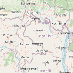
Geography guide, regional context, and park location map for Raimona National Park

Raimona National Park park geography, regions, and map view in India
Understand where Raimona National Park sits in India through a broader geographic reading of the surrounding landscape, nearby location context, and its mapped position within the national park landscape.

How Raimona National Park fits into India

India is a South Asian country bordered by the Indian Ocean, Arabian Sea, and Bay of Bengal. It shares land borders with Pakistan, China, Nepal, Bhutan, Bangladesh, and Myanmar. The country has a population of over 1.4 billion people and operates as a federal parliamentary republic with its capital in New Delhi.

Wider geography shaping Raimona National Park in India

India occupies the Indian subcontinent in South Asia, bordered by the Arabian Sea to the southwest, the Bay of Bengal to the southeast, and the Indian Ocean to the south. It shares land borders with Pakistan to the west, China, Nepal, and Bhutan to the north, and Bangladesh and Myanmar to the east. The territory also includes the Andaman and Nicobar Islands in the Indian Ocean.

Map view of Raimona National Park

Use this park location map to pinpoint Raimona National Park in India, understand its exact geographic position, and read its mapped placement within the surrounding landscape more clearly.

Pigeon | © OpenStreetMap contributors

Location context for Raimona National Park

AssamKokrajhar District
Park atlas

Explore connected conservation landscapes, Himalayan foothill terrain, and the regional spread of protected areas in Assam, India.

Discover Other National Parks and Protected Areas Near Raimona National Park in India
Discover other national parks and protected areas located near Raimona National Park, exploring a wider geographic context across India's Himalayan foothills. Compare terrain, ecosystems, and conservation priorities within this vital region, offering deeper insights into the protected-area network.
Wildlife reserveBhutan

Phibsoo Wildlife Sanctuary: Bhutan's Wildlife Reserve Atlas and Geographic Identity

Mapping the protected landscape and natural terrain of this Bhutanese sanctuary.

Delve into the specifics of Phibsoo Wildlife Sanctuary, a protected wildlife reserve situated within the geographic expanse of Bhutan. This park detail page focuses on its identity as a conservation landscape, offering insights into its mapped terrain and its significance within the broader regional geography of the Eastern Himalayas. Understand the protected boundaries and the unique natural context that Phibsoo Wildlife Sanctuary represents.

Area
268.93 km²
Established
2009
IUCN
IV
Relief
Mixed relief
National parkAlipurduar district

Jaldapara National Park: India's Premier Grassland and Rhino Conservation Landscape

Explore mapped boundaries and savanna terrain in Alipurduar district.

Jaldapara National Park is a protected national park in India's Alipurduar district, celebrated for its expansive rolling grasslands and significant population of Indian one-horned rhinoceros. This protected area showcases a distinctive savanna landscape, an unusual feature among Indian national parks, interspersed with riverine forests. Its elevation of 61 meters above sea level positions it at the edge of the Eastern Himalayas, offering a unique geographic setting for understanding regional biodiversity and conservation efforts.

Area
216.51 km²
Established
1941
IUCN
II
Relief
Lowland
National parkTrongsa District

Jigme Singye Wangchuck National Park: Bhutan National Park's Geographic and Landscape Atlas

Mapped protected area within Trongsa District's natural terrain.

Delve into the detailed geographic identity of Jigme Singye Wangchuck National Park, a protected national park situated in Bhutan's Trongsa District. This park provides essential context for understanding Bhutanese geography and conservation landscapes. Examine its mapped boundaries and place within the regional terrain, offering a structured exploration for anyone interested in national park geography and protected natural areas.

Area
1,730 km²
Established
1995
IUCN
II
Relief
Mountain
National parkAssam

Manas National Park: Assam's National Park Protected Landscape and Geographic Atlas

Explore mapped boundaries and regional landscape context.

Manas National Park offers a distinct protected landscape within the state of Assam, India. This national park is a key feature in the geography of the Brahmaputra River valley, providing valuable context for atlas-driven exploration. Understand its mapped territory and regional setting as a protected natural area.

Area
850 km²
Established
1990
IUCN
II
Relief
Mountain
Wildlife reserveBhutan

Motithang Takin Preserve: Bhutan Wildlife Reserve with Unique Protected Landscape Context

Explore the mapped geography and national animal sanctuary.

The Motithang Takin Preserve offers a unique glimpse into Bhutan's dedication to its national animal, the takin. This wildlife reserve, located near the capital city, provides a defined protected area where the distinctive goat-antelope thrives. By examining the preserve's mapped boundaries and its forested terrain, users gain insight into Bhutan's approach to conservation and the cultural significance of this iconic species within the Himalayan landscape.

Area
0.034 km²
IUCN
IV
Relief
Upland
Climate
Temperate
National parkJalpaiguri district

Gorumara National Park: India National Park Atlas and Protected Landscape Geography

Discover the mapped boundaries and regional terrain.

Gorumara National Park stands as a vital protected natural area within India's Jalpaiguri district. This entry provides detailed atlas-focused information, detailing the park's geographic identity and its position within the regional landscape context. Understand the mapped protected boundaries and explore the unique terrain that characterizes Gorumara National Park as a key national park entity. It serves as a foundational point for geographic discovery within India's network of protected lands.

Area
79.99 km²
Established
1992
IUCN
II
Relief
Mixed relief
National parkBhutan

Phrumsengla National Park: Protected Landscape and Geographic Context in Bhutan

Explore mapped boundaries and diverse Himalayan terrain.

Phrumsengla National Park serves as a vital protected area within Bhutan, characterized by its extensive altitudinal range and varied landscape. Spanning from subtropical valleys to alpine zones, the park showcases a remarkable transition of ecosystems, including significant old-growth fir forests. Its location and unique geographic features make it an important component of any study of the region's protected lands and Himalayan geography, offering rich data for atlas exploration and understanding natural landscapes.

Area
905.05 km²
Established
1998
IUCN
II
Relief
Mountain
Watercolor painting of rolling green hills, a meandering stream, and a soft pastel sky
National parkWest Garo Hills district

Nokrek National Park: Protected Mountain Landscape and Regional Geography

Explore its mapped boundaries and diverse natural terrain.

Nokrek National Park is a vital protected mountain wilderness situated in the West Garo Hills district, Meghalaya, India. Its rugged terrain, characterized by ancient geological formations and dense evergreen forests, supports remarkable biodiversity. As a key component of the Nokrek Biosphere Reserve, it offers a unique glimpse into the region's ecological significance, serving as an important source for major rivers and a sanctuary for diverse flora and fauna.

Area
47.48 km²
Established
1986
IUCN
II
Relief
Mountain

Common questions about visiting, size, designation, and location context for Raimona National Park

Raimona National Park FAQs for park facts, access, geography, and protected area context
Find quick answers about Raimona National Park, including protected-area facts, park geography, trail and visitor context, and how the park fits into its surrounding country and regional landscape.
MoriAtlas Explorer

Continue Your Protected Areas Search Across the Global Atlas

Deepen your exploration by continuing the structured search for national parks and protected areas worldwide. Utilize the comprehensive filtering capabilities to compare different conservation landscapes and refine your understanding of global park geography. Discover more about the distribution and characteristics of protected natural areas.

Global natural geography