

Mori Atlas logo
National parkBuxa Tiger Reserve

Discover the mapped boundaries and diverse terrain of this crucial tiger and elephant habitat near Bhutan.

Buxa Tiger Reserve National Park: Protected Landscape Atlas and Geographic Context

Buxa Tiger Reserve represents a significant national park nestled in India's Alipurduar district, marking the easternmost extension of the North-East India region. This protected area spans varied terrain, from Gangetic Plains to Himalayan foothills, serving as a critical international corridor for Asian elephant migration between India and Bhutan. Users exploring Buxa Tiger Reserve will gain insight into its unique geography, diverse forest types, and its importance as a protected landscape for critical wildlife populations and transboundary conservation efforts.

Tiger ReserveNational ParkEastern HimalayasTransboundary ConservationElephant CorridorBirdwatching

Buxa Tiger Reserve

National park

Park overview

Structured park overview, official facts, and landscape profile for Buxa Tiger Reserve

Buxa Tiger Reserve park facts, protected area profile, and essential visitor context

Review the core facts for Buxa Tiger Reserve, including designation, size, terrain, visitor scale, habitats, and operating context in one park-focused overview.

About Buxa Tiger Reserve

Buxa Tiger Reserve occupies a strategically important position at the interface between the Himalayan foothills and the Gangetic Plains in northern West Bengal. The reserve's northern boundary follows the international border with Bhutan, while the Sinchula hill range forms a dramatic backdrop along its northern edge. The eastern boundary abuts the state of Assam, and National Highway 31C roughly traces the southern perimeter. This location places Buxa at the easternmost extension of the bio-diverse North-East India region, representing the highly endemic Indo-Malayan zoogeographic zone. The landscape encompasses hilly terrain, Bhabhar tract (a transition zone between mountains and plains), and riverine ecosystems, creating a mosaic of habitats that support remarkable biological diversity. The reserve functions as an international corridor for Asian elephant migration, connecting protected areas in Bhutan with those in India, making it crucial for regional conservation efforts.

Quick facts and research context for Buxa Tiger Reserve

Buxa Tiger Reserve spans 760 square kilometers in northern West Bengal, India, at the eastern edge of the Himalayan foothills. The reserve was established in 1983 and achieved national park status in 1997. Its elevation ranges from 60 meters in the Gangetic Plains to 1,750 meters in the Sinchula hill range along the Bhutan border. The park shares boundaries with Phibsoo Wildlife Sanctuary to the north and Manas National Park to the east, creating a transboundary conservation corridor. The area features the Buxa Formation, a geological formation with stromatolite-bearing dolomite limestones recognized as a national geological monument.

Protection and recognition

Documenting the mixed protection scope and transboundary status established in 1997

Buxa Tiger Reserve Protection Status and Protected Area Designation

Researchers and conservation explorers can examine the official 1997 designation history, mixed protection boundaries, and transboundary framework defining the Buxa Tiger Reserve. Accessing verified regional datasets provides essential geographic context for understanding transboundary wildlife corridors and international conservation mapping.

Protection details

Protection scope
Mixed
Designated year
1997
Transboundary protection
Yes
Park context

Deeper park guide and search-rich context for Buxa Tiger Reserve

Buxa Tiger Reserve history, landscape, wildlife, and travel context

Explore Buxa Tiger Reserve through its history, landscape character, ecosystems, wildlife, conservation priorities, cultural context, and seasonal travel timing in a structured park guide built for atlas discovery and search intent.

Why Buxa Tiger Reserve stands out

Buxa Tiger Reserve is best known as a critical tiger and elephant habitat at the eastern edge of the Indian subcontinent, serving as a vital corridor for transboundary wildlife movement between India and Bhutan. The reserve is recognized for its exceptional biodiversity in the Indo-Malayan region, with particularly significant populations of Asian elephants, gaur, and various felids including the clouded leopard and Indian leopard. The park's diverse forest types, ranging from moist sal savannah to East Himalayan subtropical wet hill forest, support over 450 tree species and 284 bird species, making it one of the botanically richest protected areas in eastern India.

Buxa Tiger Reserve history and protected-area timeline

Buxa Tiger Reserve was created in 1983 as the 15th tiger reserve established in India, reflecting the country's commitment to protecting its flagship species and their habitats. In 1986, Buxa Wildlife Sanctuary was formally constituted over 314.52 square kilometers of the reserve forests, providing legal protection to the core conservation area. Additional protection came in 1991 when 54.47 square kilometers were incorporated into the wildlife sanctuary. The Government of West Bengal declared its intention in 1992 to constitute a national park over 117.10 square kilometers of the Buxa Wildlife Sanctuary, and the national park was finally declared in December 1997 through notification No.3403-For/11B-6/95. This gradual expansion of protected status reflects the evolving understanding of the area's ecological significance and the need for comprehensive conservation measures.

Buxa Tiger Reserve landscape and geographic character

The terrain of Buxa Tiger Reserve spans a remarkable elevation gradient from 60 meters in the Gangetic Plains to 1,750 meters where the reserve meets the Himalayan foothills. The Sinchula hill range rises along the northern boundary, creating a dramatic mountainous backdrop that contrasts with the lower-lying plains and river valleys. The landscape includes hilly tracts, the Bhabhar zone (a characteristic Terai transition area), and extensive riverine tracts traversed by the Jayanti River and Raidak River. The geology of the region is particularly noteworthy, as Buxa is contiguous with the Buxa Formation of Mamley in Sikkim, featuring stromatolite-bearing dolomite limestones that have been declared a national geological monument. This combination of mountainous terrain, rolling hills, river valleys, and plains creates a visually diverse landscape that supports varied ecological communities.

Buxa Tiger Reserve ecosystems, habitats, and plant life

The ecological diversity of Buxa Tiger Reserve is extraordinary, encompassing at least nine distinct forest types that reflect the transition from Himalayan to tropical biomes. These forest types include northern dry deciduous forest, eastern Bhabhar and Terai sal forest, East Himalayan moist mixed deciduous forest, sub-Himalayan secondary wet mixed forest, eastern sub-montane semi-evergreen forest, northern tropical evergreen forest, East Himalayan subtropical wet hill forest, moist sal savannah, low alluvium, and savannah woodland. The botanical richness is exceptional, with more than 450 tree species, 250 shrub species, 400 herb species, 150 orchid species, and significant representations of bamboo, cane, grass, and aquatic flora. This botanical diversity underpins the complex ecological relationships that sustain the reserve's wildlife populations.

Buxa Tiger Reserve wildlife and species highlights

Buxa Tiger Reserve supports impressive wildlife diversity with 73 mammal species, 284 recorded bird species, 65 fish species, 41 reptile species, and 4 amphibian species. The mammalian community includes significant populations of Asian elephants, gaur, sambar deer, chital, wild boar, and various felids including the Bengal tiger, Indian leopard, clouded leopard, and Asian golden cat. Notably, both plain and spotted Asiatic golden cats were recorded in the reserve for the first time in February 2018. The avifauna is particularly noteworthy, featuring species such as the rufous-necked hornbill, great hornbill, Oriental pied hornbill, and chestnut-breasted partridge. Migratory birds including the black-necked crane, black stork, and ferruginous pochard utilize the lake and river habitats. The reserve also supports several endangered species including the Bengal florican, Chinese pangolin, hispid hare, hog deer, and various vulture species.

Buxa Tiger Reserve conservation status and protection priorities

Buxa Tiger Reserve serves as a critical node in regional conservation efforts, functioning as an international corridor that enables Asian elephant migration between India and Bhutan. This transboundary connectivity is essential for maintaining viable populations of large mammals in the eastern Himalayan region. The reserve's inclusion in the network of India's tiger reserves demonstrates its national importance for flagship species conservation, while the diversity of endangered species present, including the Bengal florican, Chinese pangolin, and multiple vulture species, underscores its broader conservation significance. The geological importance of the Buxa Formation, with its stromatolite-bearing dolomite limestones, adds a dimension of geological conservation to the protected area's mandate.

Buxa Tiger Reserve cultural meaning and human context

While Buxa Tiger Reserve is primarily known for its ecological values, the region has historical significance as part of the broader Dooars region of West Bengal, which has been inhabited by various communities engaged in traditional forest use and agriculture. The Jayanti River and Raidak River that traverse the reserve have supported local communities historically, and the reserve's boundary with Bhutan reflects the historical connections between the region's peoples. The forest areas have historically provided livelihoods through non-timber forest product collection, though this use creates ongoing conservation challenges.

Top sights and standout views in Buxa Tiger Reserve

Buxa Tiger Reserve stands out as the easternmost tiger reserve in India, located at a critical biogeographic crossroads between the Himalayas and the Gangetic Plains. The reserve's significance as an international elephant corridor linking protected areas in India and Bhutan makes it essential for transboundary conservation. Its exceptional botanical diversity, with over 450 tree species and 150 orchids, supports remarkable faunal richness including elephants, tigers, leopards, and the endangered rufous-necked hornbill. The presence of the Buxa Formation geological monument adds geological significance to the protected area.

Best time to visit Buxa Tiger Reserve

The optimal time to visit Buxa Tiger Reserve is during the winter months from November through February, when the weather is cool and dry and wildlife visibility improves as animals congregate near water sources. The monsoon season from June to September brings heavy rainfall to the region, which can make some areas inaccessible and increase the risk of flooding in riverine tracts. Summer months from March to May can be extremely hot and may limit wildlife sighting opportunities, though they do provide access to different areas of the reserve.

Monthly climate preview

Long term temperature averages and monthly precipitation records across representative terrain

Buxa Tiger Reserve Climate Normals and Measured Annual Weather Patterns

Historical measurement data reveals distinct shifts in average temperature and monthly precipitation across the representative coordinate. Exploring the complete twelve month profile provides deeper insight into long term climate normals.
Annual mean24 °C
16 °C29 °C
Jan16°
Feb19°
Mar24°
Apr28°
May29°
Jun29°
Jul28°
Aug28°
Sep27°
Oct25°
Nov21°
Dec18°
Warmest month
May

29.3 °C

Coolest month
January

16.2 °C

Wettest month
July

13.3 mm/day

Driest month
December

0.1 mm/day

Park location guide

Geography guide, regional context, and park location map for Buxa Tiger Reserve

Buxa Tiger Reserve park geography, regions, and map view in India

Understand where Buxa Tiger Reserve sits in India through a broader geographic reading of the surrounding landscape, nearby location context, and its mapped position within the national park landscape.

How Buxa Tiger Reserve fits into India

India is a South Asian country bordered by the Indian Ocean, Arabian Sea, and Bay of Bengal. It shares land borders with Pakistan, China, Nepal, Bhutan, Bangladesh, and Myanmar. The country has a population of over 1.4 billion people and operates as a federal parliamentary republic with its capital in New Delhi.

Wider geography shaping Buxa Tiger Reserve in India

India occupies the Indian subcontinent in South Asia, bordered by the Arabian Sea to the southwest, the Bay of Bengal to the southeast, and the Indian Ocean to the south. It shares land borders with Pakistan to the west, China, Nepal, and Bhutan to the north, and Bangladesh and Myanmar to the east. The territory also includes the Andaman and Nicobar Islands in the Indian Ocean.

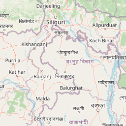
Map view of Buxa Tiger Reserve

Use this park location map to pinpoint Buxa Tiger Reserve in India, understand its exact geographic position, and read its mapped placement within the surrounding landscape more clearly.

Pigeon | © OpenStreetMap contributors

Location context for Buxa Tiger Reserve

Alipurduar districtWest Bengal
Park atlas

Trace the regional park atlas, comparing protected areas and natural landscapes surrounding Buxa Tiger Reserve.

Explore Nearby National Parks and Protected Areas Beyond Buxa Tiger Reserve

Explore additional national parks and protected areas near Buxa Tiger Reserve, tracing the geographic spread of conservation landscapes across northern West Bengal and the Eastern Himalayas. Compare diverse terrains, wildlife habitats, and ecological significance within this critical transboundary region, enhancing your atlas-based understanding of protected areas.
National parkAlipurduar district
About 31 km away#1 closest

West

Jaldapara National Park: India's Premier Grassland and Rhino Conservation Landscape

Explore mapped boundaries and savanna terrain in Alipurduar district.

Jaldapara National Park is a protected national park in India's Alipurduar district, celebrated for its expansive rolling grasslands and significant population of Indian one-horned rhinoceros. This protected area showcases a distinctive savanna landscape, an unusual feature among Indian national parks, interspersed with riverine forests. Its elevation of 61 meters above sea level positions it at the edge of the Eastern Himalayas, offering a unique geographic setting for understanding regional biodiversity and conservation efforts.

Area
216.51 km²
Established
1941
IUCN
II
Relief
Lowland
National parkKokrajhar District
About 39 km away#2 closest

East

Raimona National Park: National Park Protected Landscape and Geographic Atlas Exploration

Discover mapped terrain and regional geography within Raimona National Park.

Raimona National Park, designated as a national park within India's Kokrajhar District, offers rich opportunities for atlas-based geographic discovery. This page details the park's protected landscape, providing insights into its mapped boundaries and the surrounding natural terrain. Understanding Raimona National Park's placement within the regional geography allows for a deeper appreciation of its role as a significant protected area, perfect for detailed map exploration and landscape context.

Area
422 km²
Established
2021
IUCN
II
Relief
Mountain
Wildlife reserveBhutan
About 49 km away#3 closest

East

Phibsoo Wildlife Sanctuary: Bhutan's Wildlife Reserve Atlas and Geographic Identity

Mapping the protected landscape and natural terrain of this Bhutanese sanctuary.

Delve into the specifics of Phibsoo Wildlife Sanctuary, a protected wildlife reserve situated within the geographic expanse of Bhutan. This park detail page focuses on its identity as a conservation landscape, offering insights into its mapped terrain and its significance within the broader regional geography of the Eastern Himalayas. Understand the protected boundaries and the unique natural context that Phibsoo Wildlife Sanctuary represents.

Area
268.93 km²
Established
2009
IUCN
IV
Relief
Mixed relief
National parkAssam
About 72 km away#4 closest

East

Sikhna Jwhwlao National Park: Atlas Mapping of Assam's Indo-Bhutan Frontier Landscapes

Protected corridors and sub-Himalayan forest terrain

Sikhna Jwhwlao National Park provides a vital link between four neighbouring protected areas in the Bodoland region. The park landscape features a complex mosaic of riverine corridors and moist deciduous forests that anchor wildlife movement near the Indo-Bhutan frontier. Beyond its role as a flagship habitat for primates and rhinoceros, the park contains significant cultural heritage sites tied to Bodo history within its distinct sub-Himalayan topography.

Area
316.29 km²
Established
2025
IUCN
II
Relief
Lowland
National parkJalpaiguri district
About 78 km away#5 closest

West

Gorumara National Park: India National Park Atlas and Protected Landscape Geography

Discover the mapped boundaries and regional terrain.

Gorumara National Park stands as a vital protected natural area within India's Jalpaiguri district. This entry provides detailed atlas-focused information, detailing the park's geographic identity and its position within the regional landscape context. Understand the mapped protected boundaries and explore the unique terrain that characterizes Gorumara National Park as a key national park entity. It serves as a foundational point for geographic discovery within India's network of protected lands.

Area
79.99 km²
Established
1992
IUCN
II
Relief
Mixed relief
Wildlife reserveAssam
About 82 km away#6 closest

Southeast

Chakrashila Wildlife Sanctuary: Geography, Mapped Terrain, and Assam Protected Landscapes

A vital wildlife reserve within the Brahmaputra foothills

Chakrashila Wildlife Sanctuary represents a key ecological link in western Assam, characterized by its mix of sal-dominated hill forests and two significant freshwater wetlands, Dheer Beel and Diplai Beel. This compact reserve offers a distinct topographical study of the Brahmaputra foothills and remains a central point for understanding primate-focused habitat preservation in the region.

Area
45.568 km²
Established
1994
IUCN
IV
Water
Major water bodies
National parkKalimpong district
About 86 km away#7 closest

Northwest

Neora Valley National Park: India's Protected Landscape in Kalimpong District

Explore mapped boundaries and regional geography.

Neora Valley National Park is a significant protected area designated as a national park in India, located within the Kalimpong district. This dedicated page provides detailed geographic information, focusing on its mapped boundaries and its role as a natural landscape within the region. Understand the specific protected-area context of Neora Valley National Park for atlas-based discovery.

Area
88 km²
Established
1986
IUCN
II
Relief
Mountain
Nature reserveBhutan
About 91 km away#8 closest

Northwest

Torsa Strict Nature Reserve: Bhutan Nature Reserve Protected Landscape Discovery

Mapped geography and protected boundaries within the Eastern Himalayas.

Torsa Strict Nature Reserve represents a vital component of Bhutan's protected natural areas. This detail page offers a structured exploration of its identity as a nature reserve, focusing on its geographic placement within the country and the surrounding Himalayan terrain. Users can investigate the mapped outlines of this protected landscape, gaining a clearer understanding of its regional context and its significance for atlas-driven geographic discovery.

Area
609.51 km²
Established
1993
Relief
Mountain
Scope
Terrestrial

Common questions about visiting, size, designation, and location context for Buxa Tiger Reserve

Buxa Tiger Reserve FAQs for park facts, access, geography, and protected area context

Find quick answers about Buxa Tiger Reserve, including protected-area facts, park geography, trail and visitor context, and how the park fits into its surrounding country and regional landscape.
MoriAtlas Explorer

Continue Your Protected Areas Search Across the Global Atlas

Deepen your exploration by continuing the structured search for national parks and protected areas worldwide. Utilize the comprehensive filtering capabilities to compare different conservation landscapes and refine your understanding of global park geography. Discover more about the distribution and characteristics of protected natural areas.

Global natural geography