

Mori Atlas logo
National parkSikhna Jwhwlao National Park

Analyzing the ecological corridor and riverine terrain within the Manas Biosphere Reserve

Sikhna Jwhwlao National Park: Mapping the Protected Landscape and Transboundary Geography of Assam

Sikhna Jwhwlao National Park occupies a strategic position in the sub-Himalayan foothills of Assam, where its moist forests and grasslands form a crucial link for wildlife movement across the Indo-Bhutan border. This protected area bridges four neighbouring regions within the Manas Biosphere Reserve, maintaining a dynamic riverine habitat that supports an array of large mammals and substantial butterfly populations. The terrain reflects a transition from the plains of the Brahmaputra valley to the lower Himalayas, anchoring regional conservation efforts through its unique mosaic of riparian and deciduous landscapes.

national parkAssamBodolandManas Biosphere ReserveIndo-Bhutan bordertransboundary conservation

Sikhna Jwhwlao National Park

National park

Park overview

Structured park overview, official facts, and landscape profile for Sikhna Jwhwlao National Park

Sikhna Jwhwlao National Park park facts, protected area profile, and essential visitor context

Review the core facts for Sikhna Jwhwlao National Park, including designation, size, terrain, visitor scale, habitats, and operating context in one park-focused overview.

About Sikhna Jwhwlao National Park

Sikhna Jwhwlao National Park is a protected area in the Bodoland Territorial Region of Assam, India, established as the state's eighth national park. It lies across the Chirang and Kokrajhar districts, with its nearest major town being Kokrajhar. The park stretches along the Indo-Bhutan frontier, placing it within one of the most ecologically significant transboundary landscapes in South Asia. Its position within the Manas Biosphere Reserve framework gives it immediate regional importance, as it acts as a structural link rather than an isolated reserve.

The park's geography reflects the sub-Himalayan foothills of lower Assam, where river valleys, moist forests, and grasslands merge. This mosaic of habitats supports species that depend on intact forest cover and open forest-savanna mosaics, including large herbivores, apex predators, and a rich assemblage of smaller fauna. The park's elevational and ecological character situates it firmly within the broader Manas ecosystem, reinforcing the value of connected, landscape-scale conservation in the region.

Although Sikhna Jwhwlao was formalised as a national park only in early 2025, its ecological foundation has long been recognised through its inclusion as part of the Manas Biosphere Reserve. The park's establishment formalises protection for an area that bridges multiple existing reserves, helping to consolidate a contiguous block of habitat for species that require extensive ranges. Its mix of ecological richness and cultural significance gives the park a layered identity, both as a biological refuge and as a landscape rooted in Bodo heritage.

As a young but strategically placed protected area, Sikhna Jwhwlao National Park represents a continuation of efforts to secure the Manas landscape against fragmentation. Its creation underlines the importance of connectivity, transboundary cooperation, and inclusive conservation that recognises both biodiversity and the cultural traditions of communities who have long inhabited this region.

Quick facts and research context for Sikhna Jwhwlao National Park

Sikhna Jwhwlao National Park spans roughly 316 square kilometres across parts of Chirang and Kokrajhar districts in Bodoland, Assam. It is administered under India's Wildlife (Protection) Act, 1972, with governance shared between the Ministry of Environment, Forest and Climate Change, the Government of India, and the Government of Assam. The park was formally approved by the Assam Cabinet in February 2025 and officially notified as a national park on 5 March 2025.

The park forms part of the Manas Biosphere Reserve and connects four other protected areas in the region. Its location along the Indo-Bhutan border gives it particular importance for transboundary conservation. It is also notable for recording more than 460 species of butterflies, in addition to flagship mammals such as the golden langur and the greater one-horned rhinoceros.

Protection and recognition

Documented terrestrial protection scope, designation year, and international recognition details

Sikhna Jwhwlao National Park Protection Status and Designation History

Sikhna Jwhwlao National Park holds a documented terrestrial protection status established in twenty-twenty-five. Structured records detail the official designation history and management scope associated with this protected area.

Protection details

Protection scope
Terrestrial
Designated year
2025
Transboundary protection
No
Park context

Deeper park guide and search-rich context for Sikhna Jwhwlao National Park

Sikhna Jwhwlao National Park history, landscape, wildlife, and travel context

Explore Sikhna Jwhwlao National Park through its history, landscape character, ecosystems, wildlife, conservation priorities, cultural context, and seasonal travel timing in a structured park guide built for atlas discovery and search intent.

Why Sikhna Jwhwlao National Park stands out

Sikhna Jwhwlao National Park is best known for its role within the Manas Biosphere Reserve landscape, where it links four adjoining protected areas and strengthens wildlife corridors along the Indo-Bhutan border. The presence of the golden langur, an iconic primate of the region, alongside flagship species such as the greater one-horned rhinoceros, Royal Bengal tiger, and Asian elephant, gives the park strong conservation credentials despite its very recent establishment. The park is also distinguished by its outstanding butterfly diversity, with more than 460 recorded species, making it a significant area for invertebrate conservation in northeast India. Equally important is its cultural identity: the park is named after Sikhna Jwhwlao, a Bodo warrior leader of the Duar War era, and contains sites considered sacred by the local Bodo community, where traditional festivals continue to be observed.

Sikhna Jwhwlao National Park history and protected-area timeline

Sikhna Jwhwlao National Park has a short formal history as a designated protected area, but it emerges from a much longer cultural and ecological back story. The Government of Assam formally approved the creation of the national park during a Cabinet meeting held on 16 February 2025. Shortly afterward, the park was officially notified by the Governor of Assam on 5 March 2025, under the provisions of the Wildlife (Protection) Act, 1972. This designation made it the third national park in Bodoland and the eighth in Assam as a whole.

Although the legal protection is recent, the area has long been recognised as ecologically important through its association with the Manas Biosphere Reserve. The park's inclusion within this broader reserve framework reflects decades of conservation attention directed at the Manas landscape and its role as a hub for species such as the greater one-horned rhinoceros, the Royal Bengal tiger, and the golden langur.

Beyond conservation, the site's history is deeply intertwined with the cultural memory of the Bodo people. The park takes its name from Sikhna Jwhwlao, also known as Joulia Dewan, a legendary Bodo warrior and leader who resisted British colonial forces during the Duar War of 1864 to 1866. His historical capital, known as Sikhnajhar or Chiknajhar, lay in what is now the Ultapani Reserve, which falls within the current park boundaries. The site remains sacred to the Bodo community, where festivals such as Bathou Puja and Kherai are observed annually, anchoring the park's modern conservation identity in a deeper regional heritage.

Sikhna Jwhwlao National Park landscape and geographic character

Sikhna Jwhwlao National Park occupies a strategic position in the sub-Himalayan foothills of Assam, along the Indo-Bhutan border. The terrain reflects the transition between the plains of the Brahmaputra valley and the foothills of the lower Himalayas, producing a varied topography shaped by rivers, gentle ridges, and forest valleys. The park spans parts of both Chirang and Kokrajhar districts, and its proximity to the international boundary gives it a distinctive transboundary landscape character.

Watercourses and riverine corridors are an important part of the park's physical setting, supporting both floodplain grasslands and moist forest patches. Within the broader Manas landscape, the park contributes to a connected matrix of habitat that includes dense forest stands, open grassy stretches, and riparian zones. This landscape diversity creates varied conditions across the protected area, from shaded closed-canopy interiors to more open and dynamic river-edge environments.

The park's relatively compact footprint of roughly 316 square kilometres, combined with its location linking four other protected areas, gives its terrain particular importance for landscape-scale ecological processes. Movement of large mammals, seasonal flooding patterns, and forest regeneration all depend on the continuity of these landforms across the wider Manas-Bhutan landscape that the park now helps anchor.

Sikhna Jwhwlao National Park ecosystems, habitats, and plant life

The ecosystems within Sikhna Jwhwlao National Park reflect the ecological richness typical of the Manas Biosphere Reserve region in lower Assam. Habitats include moist deciduous forest, stretches of grassland, and significant riverine corridors along the Indo-Bhutan frontier. These habitat types combine to produce a mosaic that supports species requiring both forest cover and open areas, as well as animals tied closely to water.

Because the park forms part of the broader Manas Biosphere Reserve and connects four neighbouring protected areas, its nature is best understood in a regional context. The park contributes to maintaining ecological processes such as seasonal flooding, forest regeneration, and wildlife dispersal across a landscape that extends into Bhutan. This connectivity makes the park's habitats especially important for wide-ranging species that need large territories and stable ecological conditions.

The vegetation and habitat diversity of the park also support an exceptionally rich invertebrate fauna. The presence of more than 460 recorded butterfly species highlights the structural and floral complexity of the habitats within the park, indicating that even small changes in forest composition can sustain a remarkable array of pollinators and dependent organisms.

Sikhna Jwhwlao National Park wildlife and species highlights

Sikhna Jwhwlao National Park supports a remarkable diversity of wildlife, reflecting its position within the Manas Biosphere Reserve and its location along the Indo-Bhutan border. The park is particularly notable for its population of the golden langur, a primate of high conservation significance that is closely associated with the Manas region. This presence alone gives the park strong wildlife value, as the species remains restricted to a relatively narrow belt of habitat on either side of the international boundary.

In addition to the golden langur, the park provides habitat for several of northeast India's most iconic large mammals. The greater one-horned rhinoceros, the Royal Bengal tiger, and the Asian elephant all occur within or use habitats associated with the park, reinforcing its role as a key refuge within the Manas landscape. The combination of forest cover, grasslands, and riverine habitat creates conditions favourable to these wide-ranging species.

The park's invertebrate fauna is equally significant. With more than 460 butterfly species recorded, the park stands out as an important area for pollinator diversity in South Asia. The interplay between flagship mammals and a poorly understood but rich invertebrate fauna underscores the park's value for both broad public recognition and detailed ecological study.

Sikhna Jwhwlao National Park conservation status and protection priorities

As a recently notified national park under India's Wildlife (Protection) Act, 1972, Sikhna Jwhwlao represents an important step in strengthening the protected-area network of the Manas Biosphere Reserve. Its designation formalises protection for a strategic corridor of land that connects four other protected areas, addressing one of the core conservation challenges in the region: habitat fragmentation.

The park's transboundary position, along the Indo-Bhutan border, gives it particular conservation significance. By consolidating habitat connectivity, it supports the long-term viability of wide-ranging species such as the Royal Bengal tiger, the Asian elephant, and the greater one-horned rhinoceros, as well as more habitat-restricted species like the golden langur. Effective management of the park will play a role in maintaining genetic exchange and seasonal movement patterns across the wider Manas-Bhutan landscape.

The park's conservation profile is further strengthened by its recognition of insect biodiversity. The record of more than 460 butterfly species elevates the park's importance in invertebrate conservation, often an underrepresented component of protected-area planning. Combined with strong cultural and ecological linkages, this gives Sikhna Jwhwlao a multi-dimensional conservation role from the very outset of its formal existence.

Sikhna Jwhwlao National Park cultural meaning and human context

Sikhna Jwhwlao National Park is intimately connected to the cultural identity of the Bodo people. The park is named after Sikhna Jwhwlao, also known as Joulia Dewan, a renowned Bodo warrior and leader who led resistance against British colonial forces during the Duar War of 1864 to 1866. His historical capital, referred to as Sikhnajhar or Chiknajhar, was located in the present-day Ultapani Reserve, which now lies within the park boundaries.

The site associated with Sikhna Jwhwlao is considered sacred by the local Bodo community. Traditional religious festivals, including Bathou Puja and Kherai, continue to be observed at this location annually, anchoring the park's identity to living cultural practice rather than purely historical memory. This sacred dimension means that the park is not only a biodiversity reserve but also a landscape of cultural continuity.

The naming of the park after a revered historical figure also reflects a broader effort to recognise regional heritage within conservation frameworks. By integrating cultural and ecological values, Sikhna Jwhwlao illustrates how national park designation in Assam can serve as both a tool for biodiversity protection and a means of affirming indigenous heritage.

Top sights and standout views in Sikhna Jwhwlao National Park

Sikhna Jwhwlao National Park stands out for its strategic role within the Manas Biosphere Reserve, where it links four neighbouring protected areas and anchors a transboundary corridor along the Indo-Bhutan border. Its combination of moist deciduous forest, grasslands, and riverine habitats makes it a stronghold for flagship species such as the golden langur, the greater one-horned rhinoceros, the Royal Bengal tiger, and the Asian elephant.

Equally distinctive is the park's record of more than 460 butterfly species, which underscores the richness of its habitat mosaic. Layered on top of this is a powerful cultural dimension tied to the legacy of Sikhna Jwhwlao, a Bodo warrior of the Duar War era, whose former capital within the park remains a site of annual traditional festivals.

Best time to visit Sikhna Jwhwlao National Park

Given its location in the sub-Himalayan foothills of Assam and its inclusion within the Manas landscape, Sikhna Jwhwlao National Park shares the seasonal character of the wider region. The cooler, drier months typically offer more comfortable conditions for exploring forest and grassland habitats, while the warmer monsoon period brings heavy rainfall that transforms rivers, wetlands, and grasslands into highly active wildlife viewing environments.

Seasonal flooding and lush vegetation during and after the monsoon contribute to the park's dynamic landscape and can enhance sightings of water-dependent species. Cooler months tend to be associated with clearer forest interiors and more active mammal movement in open areas. As a very recently designated national park, visitors should look to guidance from managing authorities when planning a trip.

Monthly climate preview

Long-term representative point measurements tracking monthly averages at Sikhna Jwhwlao National Park

Sikhna Jwhwlao National Park Climate Normals, Annual Temperature and Precipitation Rhythm

Historical climatology data reveals distinct shifts in average temperature and precipitation across the recorded months at Sikhna Jwhwlao National Park. Examining the complete twelve-month meteorological profile provides deeper insight into long-term environmental patterns at this location.
Annual mean24 °C
15 °C29 °C
Jan15°
Feb18°
Mar23°
Apr27°
May28°
Jun29°
Jul28°
Aug28°
Sep27°
Oct24°
Nov20°
Dec17°
Warmest month
June

28.9 °C

Coolest month
January

15.4 °C

Wettest month
July

12.2 mm/day

Driest month
December

0.1 mm/day

Park location guide

Geography guide, regional context, and park location map for Sikhna Jwhwlao National Park

Sikhna Jwhwlao National Park park geography, regions, and map view in India

Understand where Sikhna Jwhwlao National Park sits in India through a broader geographic reading of the surrounding landscape, nearby location context, and its mapped position within the national park landscape.

How Sikhna Jwhwlao National Park fits into India

India is a South Asian country bordered by the Indian Ocean, Arabian Sea, and Bay of Bengal. It shares land borders with Pakistan, China, Nepal, Bhutan, Bangladesh, and Myanmar. The country has a population of over 1.4 billion people and operates as a federal parliamentary republic with its capital in New Delhi.

Wider geography shaping Sikhna Jwhwlao National Park in India

India occupies the Indian subcontinent in South Asia, bordered by the Arabian Sea to the southwest, the Bay of Bengal to the southeast, and the Indian Ocean to the south. It shares land borders with Pakistan to the west, China, Nepal, and Bhutan to the north, and Bangladesh and Myanmar to the east. The territory also includes the Andaman and Nicobar Islands in the Indian Ocean.

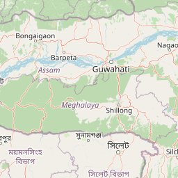
Map view of Sikhna Jwhwlao National Park

Use this park location map to pinpoint Sikhna Jwhwlao National Park in India, understand its exact geographic position, and read its mapped placement within the surrounding landscape more clearly.

Pigeon | © OpenStreetMap contributors

Location context for Sikhna Jwhwlao National Park

Assam
Park atlas

Discover related national parks and connected conservation landscapes across the region.

Exploring Parks Near Sikhna Jwhwlao National Park and Surrounding Protected Areas

Compare Sikhna Jwhwlao National Park with adjacent protected areas across the sub Himalayan foothills and surrounding riverine corridors. Broaden your regional park exploration by examining connected transboundary wildlife habitats and neighbouring conservation zones.
Wildlife reserveBhutan
About 27 km away#1 closest

West

Phibsoo Wildlife Sanctuary: Bhutan's Wildlife Reserve Atlas and Geographic Identity

Mapping the protected landscape and natural terrain of this Bhutanese sanctuary.

Delve into the specifics of Phibsoo Wildlife Sanctuary, a protected wildlife reserve situated within the geographic expanse of Bhutan. This park detail page focuses on its identity as a conservation landscape, offering insights into its mapped terrain and its significance within the broader regional geography of the Eastern Himalayas. Understand the protected boundaries and the unique natural context that Phibsoo Wildlife Sanctuary represents.

Area
268.93 km²
Established
2009
IUCN
IV
Relief
Mixed relief
National parkKokrajhar District
About 32 km away#2 closest

West

Raimona National Park: National Park Protected Landscape and Geographic Atlas Exploration

Discover mapped terrain and regional geography within Raimona National Park.

Raimona National Park, designated as a national park within India's Kokrajhar District, offers rich opportunities for atlas-based geographic discovery. This page details the park's protected landscape, providing insights into its mapped boundaries and the surrounding natural terrain. Understanding Raimona National Park's placement within the regional geography allows for a deeper appreciation of its role as a significant protected area, perfect for detailed map exploration and landscape context.

Area
422 km²
Established
2021
IUCN
II
Relief
Mountain
Wildlife reserveAssam
About 42 km away#3 closest

South

Chakrashila Wildlife Sanctuary: Geography, Mapped Terrain, and Assam Protected Landscapes

A vital wildlife reserve within the Brahmaputra foothills

Chakrashila Wildlife Sanctuary represents a key ecological link in western Assam, characterized by its mix of sal-dominated hill forests and two significant freshwater wetlands, Dheer Beel and Diplai Beel. This compact reserve offers a distinct topographical study of the Brahmaputra foothills and remains a central point for understanding primate-focused habitat preservation in the region.

Area
45.568 km²
Established
1994
IUCN
IV
Water
Major water bodies
National parkBhutan
About 50 km away#4 closest

Northeast

Royal Manas National Park: Bhutan's Premier Protected Area and Oldest National Park

Explore the mapped terrain and diverse ecosystems of this landmark Bhutanese conservation area.

Royal Manas National Park, Bhutan's first national park established in 1966, serves as a critical conservation hub in the Eastern Himalayas. Spanning over 1,057 square kilometers, it protects a vast array of landscapes, from lowland tropical forests to permanent ice fields. Its designation as the kingdom's conservation showpiece and its role in transboundary protection underscore its immense geographic and ecological importance within Bhutan.

Area
1,057 km²
Established
1966
IUCN
II
Relief
Mountain
National parkTrongsa District
About 63 km away#5 closest

North

Jigme Singye Wangchuck National Park: Bhutan National Park's Geographic and Landscape Atlas

Mapped protected area within Trongsa District's natural terrain.

Delve into the detailed geographic identity of Jigme Singye Wangchuck National Park, a protected national park situated in Bhutan's Trongsa District. This park provides essential context for understanding Bhutanese geography and conservation landscapes. Examine its mapped boundaries and place within the regional terrain, offering a structured exploration for anyone interested in national park geography and protected natural areas.

Area
1,730 km²
Established
1995
IUCN
II
Relief
Mountain
National parkAssam
About 63 km away#6 closest

East

Manas National Park: Assam's National Park Protected Landscape and Geographic Atlas

Explore mapped boundaries and regional landscape context.

Manas National Park offers a distinct protected landscape within the state of Assam, India. This national park is a key feature in the geography of the Brahmaputra River valley, providing valuable context for atlas-driven exploration. Understand its mapped territory and regional setting as a protected natural area.

Area
850 km²
Established
1990
IUCN
II
Relief
Mountain
National parkAlipurduar district
About 72 km away#7 closest

West

Buxa Tiger Reserve National Park: Protected Landscape Exploration in Alipurduar District

Mapped boundaries and diverse ecosystems within India's easternmost tiger reserve.

Buxa Tiger Reserve, a designated national park in India's Alipurduar district, offers a profound look into a protected landscape at the crossroads of major biogeographic zones. Its terrain ascends from the Gangetic Plains to the Himalayan foothills, showcasing a rich tapestry of forest types and supporting significant faunal diversity. This reserve functions as a crucial international elephant corridor, facilitating wildlife movement between India and Bhutan, and stands as a testament to the importance of mapped protected areas in transboundary conservation efforts.

Area
760 km²
Established
1983
IUCN
II
Relief
Mixed relief
National parkBhutan
About 92 km away#8 closest

Northeast

Phrumsengla National Park: Protected Landscape and Geographic Context in Bhutan

Explore mapped boundaries and diverse Himalayan terrain.

Phrumsengla National Park serves as a vital protected area within Bhutan, characterized by its extensive altitudinal range and varied landscape. Spanning from subtropical valleys to alpine zones, the park showcases a remarkable transition of ecosystems, including significant old-growth fir forests. Its location and unique geographic features make it an important component of any study of the region's protected lands and Himalayan geography, offering rich data for atlas exploration and understanding natural landscapes.

Area
905.05 km²
Established
1998
IUCN
II
Relief
Mountain

Common questions about visiting, size, designation, and location context for Sikhna Jwhwlao National Park

Sikhna Jwhwlao National Park FAQs for park facts, access, geography, and protected area context

Find quick answers about Sikhna Jwhwlao National Park, including protected-area facts, park geography, trail and visitor context, and how the park fits into its surrounding country and regional landscape.
MoriAtlas Explorer

Continue Your Protected Areas Search Across the Global Atlas

Deepen your exploration by continuing the structured search for national parks and protected areas worldwide. Utilize the comprehensive filtering capabilities to compare different conservation landscapes and refine your understanding of global park geography. Discover more about the distribution and characteristics of protected natural areas.

Global natural geography