Mori Atlas logo
National parkKhangchendzonga National Park

Discover mapped boundaries and regional geography within Sikkim's protected areas.

Khangchendzonga National Park: Protected Landscape & National Park Atlas Entry

Khangchendzonga National Park stands as a protected natural landscape within the region of Sikkim, India. This page offers an atlas-centric view of the park, detailing its geographic scope and position within India's protected areas. Users can explore the park's mapped boundaries, understand its regional landscape context, and engage with its identity as a national park for structured geographic discovery.

Himalayan national parksUNESCO World Heritage SitesMixed heritage sitesHigh altitude protected areasBirdwatching destinationsMountain conservation

Khangchendzonga National Park

National park

Park overview

Structured park overview, official facts, and landscape profile for Khangchendzonga National Park

Khangchendzonga National Park park facts, protected area profile, and essential visitor context
Review the core facts for Khangchendzonga National Park, including designation, size, terrain, visitor scale, habitats, and operating context in one park-focused overview.

About Khangchendzonga National Park

Khangchendzonga National Park represents one of India's most significant protected areas, established in 1977 to safeguard the exceptional natural heritage of the Sikkim Himalayas. The park's territory stretches across dramatic terrain that captures the full ecological spectrum of the eastern Himalayas, from lush temperate forests in the valleys to the stark beauty of glacial zones above 8,000 meters. The park's crown jewel, Mount Kangchenjunga, dominates the skyline and holds deep cultural significance for the indigenous Lepcha and Bhutia communities who have inhabited these mountains for generations. The inclusion of Khangchendzonga on the UNESCO World Heritage List in 2016 marked a watershed moment for Indian conservation, as the first mixed heritage site in the country recognized for both its outstanding natural universal value and its cultural significance. This dual recognition acknowledges not only the park's extraordinary biodiversity and geological features but also the traditional knowledge and spiritual connections that local communities maintain with this landscape. The park's transboundary position, connecting with protected areas in Nepal and Tibet, creates one of the most extensive high-altitude conservation networks in Asia.

Quick facts and research context for Khangchendzonga National Park

Khangchendzonga National Park spans 1,784 square kilometers across Mangan and Gyalshing districts in Sikkim, India. Established in 1977, the park protects an extraordinary vertical gradient of ecosystems from temperate forests through subalpine zones to perpetual snow and glacial terrain. The park is home to approximately 550 bird species and supports significant populations of Himalayan wildlife including the dhole, a wild canid rarely observed in the region. The area holds deep cultural significance for local communities and has been recognized by UNESCO as a mixed heritage site combining natural and cultural values.

Park context

Deeper park guide and search-rich context for Khangchendzonga National Park

Khangchendzonga National Park history, landscape, wildlife, and travel context
Explore Khangchendzonga National Park through its history, landscape character, ecosystems, wildlife, conservation priorities, cultural context, and seasonal travel timing in a structured park guide built for atlas discovery and search intent.

Why Khangchendzonga National Park stands out

Khangchendzonga National Park is best known for its dramatic Himalayan scenery centered on Mount Kangchenjunga, the world's third-highest peak. The park's significance extends beyond its spectacular alpine landscapes to include its status as India's first UNESCO Mixed Heritage site, recognizing both natural and cultural values. The park protects a remarkable diversity of habitats across its extreme elevation range, from temperate broadleaf and mixed forests of oak, fir, birch, maple, and willow at lower elevations to alpine meadows and perpetual snow at higher altitudes. Its position as a transboundary protected area linking conservation landscapes across India, Nepal, and Tibet adds to its global importance for wildlife conservation and ecological connectivity.

Khangchendzonga National Park history and protected-area timeline

Khangchendzonga National Park was established in 1977 as a protected area dedicated to preserving the unique Himalayan ecosystems of Sikkim. For decades, the park served as an important conservation unit within India's national park system, protecting critical habitat for Himalayan wildlife and maintaining ecological integrity across its vast mountainous terrain. The park's historical significance extends beyond modern conservation to encompass the deep cultural heritage of the region, where the mountain has been revered as sacred by local communities for centuries. The gradual expansion of tourism and trekking activities in the surrounding areas prompted enhanced attention to conservation management and boundary delineation. The successful inscription as a UNESCO World Heritage Site in 2016 represented the culmination of decades of conservation work and advocacy, bringing international recognition to the park's outstanding universal value. This designation also led to inclusion in UNESCO's Man and the Biosphere Programme, further strengthening the conservation framework around the park.

Khangchendzonga National Park landscape and geographic character

The landscape of Khangchendzonga National Park presents an awe-inspiring tapestry of Himalayan terrain that showcases the geological forces shaping the world's highest mountain range. The park encompasses an extraordinary elevation gradient spanning nearly 7,000 meters, creating a succession of distinct landscape zones from forested valleys to ice-capped peaks. Temperate broadleaf and mixed forests cloak the lower slopes, dominated by towering oaks, firs, birches, maples, and willows that create a dense green mantle across the mountain sides. As elevation increases, these forests give way to subalpine and alpine zones characterized by rhododendron scrub, alpine grasses, and scattered shrubs adapted to harsh conditions. Above approximately 4,500 meters, the landscape transforms into a realm of permanent snow and ice, with glaciers descending from the high peaks into U-shaped valleys carved by ancient ice. The Goecha La pass offers one of the most spectacular viewpoints in the park, providing commanding views of Kangchenjunga's massive ice-capped walls and surrounding peaks. The landscape is scored by numerous glacial streams and rivers that descend through the park, feeding downstream ecosystems and supporting local communities.

Khangchendzonga National Park ecosystems, habitats, and plant life

The ecological diversity of Khangchendzonga National Park reflects its position at a biogeographic crossroads where temperate, subalpine, and alpine ecosystems converge. The park's vegetation follows a clear altitudinal zonation, with temperate broadleaf and mixed forests occupying the lower elevations and transitioning into coniferous forests before giving way to alpine meadows at higher altitudes. These forests support extraordinary biodiversity, with the park serving as a critical refuge for numerous plant species including many with documented medicinal properties. The alpine zones feature specialized vegetation adapted to extreme conditions, including cushion plants, dwarf shrubs, and seasonal wildflower displays that carpet the meadows during the brief growing season. The park's location along a major Himalayan flyway and its diverse habitats make it a critical area for avian biodiversity, while the extensive wilderness areas provide habitat for elusive carnivores and other mammal species that require large territories.

Khangchendzonga National Park wildlife and species highlights

Khangchendzonga National Park supports a remarkable diversity of wildlife, with particular significance for birdlife and Himalayan mammal species. The park records approximately 550 bird species, making it one of the most bird-rich protected areas in the Himalayas. Notable avian residents include the blood pheasant, the state bird of Sikkim, along with the satyr tragopan, impeyan pheasant, and numerous other pheasant species. Raptors patrol the skies throughout the park, with species including the osprey, Himalayan griffon, lammergeier, and various eagles. The park also supports populations of green pigeons, Tibetan snowcock, snow pigeon, Asian emerald cuckoo, and sunbirds. Among mammals, the dhole, also known as the Indian wild dog, has been documented by camera traps at elevations between 2,501 and 4,100 meters, indicating the presence of this elusive canid in the park's subalpine zones. The diverse habitats likely support additional mammal species including various deer, primates, and smaller carnivores, though systematic surveys of mammalian diversity remain limited.

Khangchendzonga National Park conservation status and protection priorities

Khangchendzonga National Park holds exceptional conservation significance as India's first UNESCO Mixed Heritage site, recognized in 2016 for both its outstanding natural and cultural values. The park's designation under IUCN Category II reflects its primary objective of protecting natural ecosystems while allowing for sustainable visitor use. The inclusion in UNESCO's Man and the Biosphere Programme provides an additional framework for balancing conservation with sustainable development in the surrounding region. The park's transboundary position, linking with protected areas in Nepal and Tibet, creates opportunities for coordinated conservation action across international boundaries, particularly for mobile species that require large contiguous habitats. The protection of this Himalayan landscape is critical given the region's vulnerability to climate change, which threatens alpine ecosystems, glacial retreat, and the unique biodiversity that has evolved in these high-altitude environments. The park's designation as a mixed heritage site also recognizes the importance of maintaining the traditional relationships between local communities and this sacred mountain landscape.

Khangchendzonga National Park cultural meaning and human context

The landscape of Khangchendzonga holds profound cultural significance for the indigenous communities of Sikkim, particularly the Lepcha people who consider the mountain and surrounding forests as sacred. The Bhutia community, who migrated from Tibet, also maintain deep spiritual connections to this landscape, with the mountains featuring prominently in their religious traditions and oral histories. The name Kangchenjunga itself derives from Tibetan and Lepcha roots, roughly translating as "The Five Treasures of the Great Snow" referring to the five peaks that comprise the mountain's distinctive silhouette. For generations, these communities have practiced sustainable land use patterns that have shaped the landscape while maintaining ecological balance. The park's recognition as a Mixed Heritage site by UNESCO explicitly acknowledges this cultural dimension, making it unique among India's natural protected areas. Traditional practices including selective harvesting of forest products, rotational grazing, and spiritual ceremonies that protect specific localities have contributed to the conservation of biological diversity while maintaining cultural identity.

Top sights and standout views in Khangchendzonga National Park

Khangchendzonga National Park offers visitors the opportunity to experience one of the most spectacular mountain landscapes on Earth, with Kangchenjunga's towering peaks forming an unforgettable backdrop. The park's status as India's first UNESCO Mixed Heritage site underscores its dual significance for both natural conservation and cultural preservation. Trekking routes through the park provide access to some of the most scenically dramatic terrain in the Himalayas, with the Goecha La pass offering iconic views of the Kangchenjunga massif. The exceptional bird diversity, with over 550 species recorded, makes the park a destination of particular interest for avian enthusiasts. The park's position at the intersection of three major conservation jurisdictions creates a transboundary landscape of global importance for Himalayan biodiversity.

Best time to visit Khangchendzonga National Park

The optimal seasons for visiting Khangchendzonga National Park are spring and autumn, when weather conditions are most stable and the landscape offers the most spectacular scenery. Spring brings rhododendron blooms to the forests and subalpine zones, creating vibrant displays of color against the mountainous backdrop. Autumn typically offers clear skies and excellent visibility for viewing the high peaks, with comfortable daytime temperatures at lower elevations. Summer monsoon season brings heavy rainfall that can make trails difficult and present landslide hazards in the steep terrain. Winter visits are possible but challenging due to heavy snow at higher elevations and limited access to many areas. The timing of visits should account for the park's high altitude, with conditions at Goecha La and other high-elevation areas remaining cold even during summer months.

Park location guide

Geography guide, regional context, and park location map for Khangchendzonga National Park

Khangchendzonga National Park park geography, regions, and map view in India
Understand where Khangchendzonga National Park sits in India through a broader geographic reading of the surrounding landscape, nearby location context, and its mapped position within the national park landscape.

How Khangchendzonga National Park fits into India

India is a South Asian country bordered by the Indian Ocean, Arabian Sea, and Bay of Bengal. It shares land borders with Pakistan, China, Nepal, Bhutan, Bangladesh, and Myanmar. The country has a population of over 1.4 billion people and operates as a federal parliamentary republic with its capital in New Delhi.

Wider geography shaping Khangchendzonga National Park in India

India occupies the Indian subcontinent in South Asia, bordered by the Arabian Sea to the southwest, the Bay of Bengal to the southeast, and the Indian Ocean to the south. It shares land borders with Pakistan to the west, China, Nepal, and Bhutan to the north, and Bangladesh and Myanmar to the east. The territory also includes the Andaman and Nicobar Islands in the Indian Ocean.

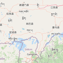
Map view of Khangchendzonga National Park

Use this park location map to pinpoint Khangchendzonga National Park in India, understand its exact geographic position, and read its mapped placement within the surrounding landscape more clearly.

Pigeon | © OpenStreetMap contributors

Location context for Khangchendzonga National Park

Sikkim
Park atlas

Uncover surrounding high-altitude landscapes and trace connected transboundary conservation areas adjacent to Khangchendzonga.

Explore Nearby National Parks and Protected Areas Beyond Khangchendzonga National Park in the Himalayas
From Khangchendzonga National Park, browse additional protected areas and national parks that share the dramatic Himalayan geography of Sikkim and the wider region. Compare diverse alpine ecosystems, mountain ranges, and conservation landscapes across this globally significant transboundary setting.
National parkDarjeeling District

Singalila National Park: A High-Altitude Protected Landscape on the Eastern Himalayan Ridge

Explore mapped terrain and alpine park geography in Darjeeling District.

Singalila National Park represents a crucial protected natural landscape within the Eastern Himalayas, located in India's Darjeeling District. Defined by its dramatic ridgeline that ascends to over 4,000 meters, the park offers a unique alpine environment with stunning panoramic views. Its designation as a national park highlights its importance for conservation and its role in the regional geographic atlas. Discover the mapped boundaries and ecological context of this remarkable mountain wilderness, from its dense forests to its open alpine meadows.

Area
78.6 km²
Established
1986
IUCN
II
Relief
Mountain
National parkKalimpong district

Neora Valley National Park: India's Protected Landscape in Kalimpong District

Explore mapped boundaries and regional geography.

Neora Valley National Park is a significant protected area designated as a national park in India, located within the Kalimpong district. This dedicated page provides detailed geographic information, focusing on its mapped boundaries and its role as a natural landscape within the region. Understand the specific protected-area context of Neora Valley National Park for atlas-based discovery.

Area
88 km²
Established
1986
IUCN
II
Relief
Mountain
National parkJalpaiguri district

Gorumara National Park: India National Park Atlas and Protected Landscape Geography

Discover the mapped boundaries and regional terrain.

Gorumara National Park stands as a vital protected natural area within India's Jalpaiguri district. This entry provides detailed atlas-focused information, detailing the park's geographic identity and its position within the regional landscape context. Understand the mapped protected boundaries and explore the unique terrain that characterizes Gorumara National Park as a key national park entity. It serves as a foundational point for geographic discovery within India's network of protected lands.

Area
79.99 km²
Established
1992
IUCN
II
Relief
Mixed relief
Watercolor illustration of mountain landscape with green slopes and blue peaks, showing a valley with yellow flowers in the foreground
National parkKoshi Province

Makalu Barun National Park: Protected Landscape and Regional Geography in Koshi Province

Explore the mapped boundaries of this national park.

Makalu Barun National Park is a designated national park providing critical protected landscape data for geographic discovery. Understand its position within Koshi Province and its specific mapped boundaries, offering insights into Nepal's protected areas. This entry is designed for users seeking detailed atlas information on the park's terrain and its role in regional conservation contexts.

Area
1,500 km²
Established
1992
IUCN
II
Relief
Mountain
National parkBhutan

Jigme Dorji National Park: Bhutan's Vast Protected Landscape and Himalayan Geography

Explore mapped boundaries and diverse ecosystems within this national park.

Jigme Dorji National Park, located in the heart of Bhutan, is a testament to the country's commitment to conservation, covering over 4,300 square kilometers of pristine Himalayan terrain. This national park encompasses diverse ecosystems, from lush subtropical forests in its lower reaches to barren alpine meadows and permanent snowfields at its highest elevations. The park's extensive mapped boundaries showcase a landscape vital for unique wildlife and sacred cultural sites, offering a comprehensive view for atlas-based geographic discovery.

Area
4,316 km²
Established
1974
IUCN
II
Relief
Mountain
Wildlife reserveBhutan

Motithang Takin Preserve: Bhutan Wildlife Reserve with Unique Protected Landscape Context

Explore the mapped geography and national animal sanctuary.

The Motithang Takin Preserve offers a unique glimpse into Bhutan's dedication to its national animal, the takin. This wildlife reserve, located near the capital city, provides a defined protected area where the distinctive goat-antelope thrives. By examining the preserve's mapped boundaries and its forested terrain, users gain insight into Bhutan's approach to conservation and the cultural significance of this iconic species within the Himalayan landscape.

Area
0.034 km²
IUCN
IV
Relief
Upland
Climate
Temperate
National parkAlipurduar district

Jaldapara National Park: India's Premier Grassland and Rhino Conservation Landscape

Explore mapped boundaries and savanna terrain in Alipurduar district.

Jaldapara National Park is a protected national park in India's Alipurduar district, celebrated for its expansive rolling grasslands and significant population of Indian one-horned rhinoceros. This protected area showcases a distinctive savanna landscape, an unusual feature among Indian national parks, interspersed with riverine forests. Its elevation of 61 meters above sea level positions it at the edge of the Eastern Himalayas, offering a unique geographic setting for understanding regional biodiversity and conservation efforts.

Area
216.51 km²
Established
1941
IUCN
II
Relief
Lowland
National parkKoshi Province

Sagarmatha National Park: Mapped Protected Landscape and Geographic Identity in Koshi Province

Explore the protected area's regional geographic context.

Sagarmatha National Park serves as a distinct protected national park entity. This page facilitates an in-depth understanding of its mapped boundaries and its location within Koshi Province. Users can explore the park's specific landscape characteristics and its position within the broader regional geography, providing a foundation for atlas and map-driven discovery.

Area
1,148 km²
Established
1976
IUCN
II
Visitors
19K annual

Common questions about visiting, size, designation, and location context for Khangchendzonga National Park

Khangchendzonga National Park FAQs for park facts, access, geography, and protected area context
Find quick answers about Khangchendzonga National Park, including protected-area facts, park geography, trail and visitor context, and how the park fits into its surrounding country and regional landscape.
MoriAtlas Explorer

Continue Your Protected Areas Search Across the Global Atlas

Deepen your exploration by continuing the structured search for national parks and protected areas worldwide. Utilize the comprehensive filtering capabilities to compare different conservation landscapes and refine your understanding of global park geography. Discover more about the distribution and characteristics of protected natural areas.

Global natural geography