Mori Atlas logo
National parkNawabganj National Park

Discover the mapped boundaries and geographic context of this protected area.

Nawabganj National Park: A Protected National Park within Bangladesh's Natural Landscape

Nawabganj National Park stands as a significant protected area within the deltaic geography of Bangladesh. As a designated National Park, it offers a focused view into the country's natural landscapes and conservational efforts. This page serves as a gateway to understanding its specific geographic footprint, mapped boundaries, and its role within the broader regional context, providing essential data for landscape exploration.

National ParkProtected AreaDeciduous ForestSal ForestTeak ForestWildlife Conservation

Nawabganj National Park

National park

Park overview

Structured park overview, official facts, and landscape profile for Nawabganj National Park

Nawabganj National Park park facts, protected area profile, and essential visitor context
Review the core facts for Nawabganj National Park, including designation, size, terrain, visitor scale, habitats, and operating context in one park-focused overview.

About Nawabganj National Park

Nawabganj National Park is located in the northwest of Bangladesh within Dinajpur District, one of the country's northernmost administrative regions. The park sits in Nawabganj Upazila, an area that has experienced significant land-use change as agriculture expanded across what were historically forested lands. The protected area preserves seven distinct forest blocks that collectively represent the remnants of a larger forest ecosystem. The dominance of sal trees (Shorea robusta) gives the park its local identity as the Shalban Garden, a reference to the extensive sal forests that once covered this part of the Himalayan piedmont. The presence of teak plantation sections alongside natural sal regeneration reflects the mixed character of the forest, which includes both native species and introduced commercial timber species. The park serves dual purposes of biodiversity conservation and tourism development, providing a natural counterpoint to the predominantly agricultural landscape surrounding it. Management focuses on maintaining habitat quality for the resident wildlife species while also offering recreational and educational opportunities for visitors.

Quick facts and research context for Nawabganj National Park

Nawabganj National Park covers 517.61 hectares in Dinajpur District, northern Bangladesh, near the town of Nawabganj. The protected area was officially designated on 24 October 2010 by the Bangladeshi government. The park features semi-natural forest dominated by teak and sal (Shorea robusta) trees, with the sal forest locally known as Nawabganj Shal Bagaan or Shalban Garden. Additional tree species include Gmelina arborea, Eucalyptus regnans, Syzygium cumini, and Acacia auriculiformis. Wildlife present includes Bengal fox, jungle cat, fishing cat, and various snake species.

Park context

Deeper park guide and search-rich context for Nawabganj National Park

Nawabganj National Park history, landscape, wildlife, and travel context
Explore Nawabganj National Park through its history, landscape character, ecosystems, wildlife, conservation priorities, cultural context, and seasonal travel timing in a structured park guide built for atlas discovery and search intent.

Why Nawabganj National Park stands out

Nawabganj National Park is best known for its semi-natural sal and teak forests in Bangladesh's northern agricultural landscape. The park preserves what remains of the Shalban Garden, a historic sal forest formation that once characterized much of the region. Its IUCN Category IV designation reflects management focused on maintaining viable populations of species including the Bengal fox, jungle cat, and fishing cat. The park represents one of the few remaining forested patches in heavily cultivated Dinajpur District.

Nawabganj National Park history and protected-area timeline

Nawabganj National Park was officially established by the government of Bangladesh on 24 October 2010. The designation came in response to growing recognition of the ecological value of remaining forest patches in Dinajpur District and the need to protect them from further agricultural encroachment. The park was created under Bangladesh's national park legislation, which provides protected status to areas of national significance for conservation, recreation, and environmental education. Prior to formal protection, the forest areas within the park had been subject to varying degrees of management, with sections used for timber production and other forest products. The establishment as a national park represented a shift toward conservation-focused management with the dual goals of preserving flora and fauna while developing sustainable tourism infrastructure.

Nawabganj National Park landscape and geographic character

The landscape of Nawabganj National Park consists of gently undulating terrain characteristic of the Himalayan piedmont zone in northern Bangladesh. The forest floor supports a mix of deciduous tree species with sal and teak forming the canopy layer. The terrain includes small watercourses and low-lying areas that provide wet-season drainage and support moisture-loving vegetation. The forest structure varies across the park's seven component areas, with some sections showing more intact canopy cover than others. The park's location in Dinajpur District places it in a region where the landscape transitions from the more heavily forested Chittagong Hill Tracts in the southeast toward the alluvial plains of the Padma River system to the southwest.

Nawabganj National Park ecosystems, habitats, and plant life

The ecological character of Nawabganj National Park reflects its position in the tropical deciduous forest zone of Bangladesh. The sal tree (Shorea robusta) dominates the forest, representing a species that once formed extensive forests across the northeastern Indian subcontinent. The tree species composition includes Gmelina arborea, a native hardwood species valued for its timber, alongside introduced species such as Eucalyptus regnans and Acacia auriculiformis. Syzygium cumini, also known as Java plum, adds to the diversity of native species. The orchid family is represented by several species occurring in the park. The forest supports a semi-natural ecosystem where native species coexist with planted timber species, creating a heterogeneous habitat structure that supports various wildlife species.

Nawabganj National Park wildlife and species highlights

The wildlife community at Nawabganj National Park includes several mammal species characteristic of deciduous forest habitats in the subcontinent. The Bengal fox represents one of the smaller carnivores present, adapted to hunting small prey in the forest understory. The jungle cat, a medium-sized felid, occupies similar ecological niches while the fishing cat demonstrates adaptation to wetland areas within the park. Snake species are present in the forest, though the specific species composition is not detailed in available sources. The park's location in northern Bangladesh places it at the northwestern edge of the species ranges for many South Asian forest animals, making the protected area important for maintaining connectivity between populations in Bangladesh and adjacent regions of India.

Nawabganj National Park conservation status and protection priorities

Nawabganj National Park holds IUCN Category IV protected area status, indicating management focused on habitat and species conservation through active intervention where necessary. The Category IV designation is appropriate for areas that serve as refuges for specific species or communities and where conservation outcomes depend on management actions such as habitat maintenance, restoration, or species monitoring. The park's establishment in 2010 reflected Bangladesh's commitment to expanding its protected area network to cover representative samples of remaining ecosystems. In a district where agricultural conversion has reduced natural forest cover significantly, the park provides protection for forest-dependent species and preserves genetic resources of economically important tree species.

Nawabganj National Park cultural meaning and human context

The Nawabganj area takes its name from historical administrative divisions, with Nawabganj Upazila serving as a local government unit. The forest has historical significance as the Shalban Garden, a reference to the sal forest that characterized the region before widespread agricultural expansion. Local communities in the surrounding area have historically depended on forest resources for timber, fuelwood, and non-timber forest products, though the establishment of the national park has restricted such activities within the protected boundaries. The area's location near the border with India places it within a broader cultural and ecological landscape that extends across national boundaries.

Top sights and standout views in Nawabganj National Park

Nawabganj National Park preserves one of the few remaining semi-natural forest areas in Dinajpur District. The sal forest, locally known as the Shalban Garden, represents the legacy of extensive deciduous forests that once covered this part of northern Bangladesh. The park provides habitat for three carnivore species: Bengal fox, jungle cat, and fishing cat, each representing different ecological niches within the forest ecosystem. The seven forest blocks included in the park create a mosaic of habitats that supports both native species and introduced timber species.

Best time to visit Nawabganj National Park

The optimal time to visit Nawabganj National Park falls during the cooler dry season from November through February, when temperatures are comfortable for outdoor exploration and the forest landscape remains accessible. The monsoon season from June to September brings heavy rainfall to Dinajpur District, potentially affecting access and visibility within the park. Winter months offer pleasant conditions for wildlife viewing, though the dry season may concentrate animals around remaining water sources. The park can be visited year-round though summer months from March to May bring higher temperatures that may limit daytime activities.
Park location guide

Geography guide, regional context, and park location map for Nawabganj National Park

Nawabganj National Park park geography, regions, and map view in Bangladesh
Understand where Nawabganj National Park sits in Bangladesh through a broader geographic reading of the surrounding landscape, nearby location context, and its mapped position within the national park landscape.

How Nawabganj National Park fits into Bangladesh

Bangladesh, officially the People's Republic of Bangladesh, is a South Asian country known for its high population density and deltaic geography formed by the Ganges-Brahmaputra river system. It gained independence from Pakistan in 1971 following a liberation war. The country operates as a unitary parliamentary republic with Dhaka as its capital and largest city, while Chittagong serves as the second-largest city and main port.

Wider geography shaping Nawabganj National Park in Bangladesh

Bangladesh occupies the delta region at the confluence of the Ganges, Brahmaputra, and Meghna rivers in South Asia. The country shares land borders with India to the north, west, and east, and Myanmar to the southeast, while its southern boundary is along the Bay of Bengal. The terrain is predominantly low-lying deltaic plain, making it susceptible to flooding. The country is separated from Bhutan and Nepal by the Siliguri Corridor and from China by the Indian state of Sikkim.

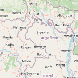
Map view of Nawabganj National Park

Use this park location map to pinpoint Nawabganj National Park in Bangladesh, understand its exact geographic position, and read its mapped placement within the surrounding landscape more clearly.

Pigeon | © OpenStreetMap contributors

Location context for Nawabganj National Park

Dinajpur DistrictNawabganj Upazila
Park atlas

Compare forested landscapes and conservation efforts across northern Bangladesh.

Discover Other National Parks and Protected Areas Near Nawabganj National Park
Continue your park exploration by examining other protected areas and forest ecosystems situated close to Nawabganj National Park in northern Bangladesh. This contextual view helps you trace the regional spread of conservation efforts and understand diverse protected landscapes beyond a single park entity.
Watercolor painting of a river flowing through a valley surrounded by hills and dense green vegetation
National parkNaogaon District

Altadighi National Park: Bangladesh's Protected Wetland Reserve in Naogaon District

Explore its mapped terrain and unique wetland ecosystem.

Altadighi National Park in Naogaon District, Bangladesh, is a protected nature reserve notable for its significant reservoir and wetland environment. Designated as a national park, it plays a crucial role in conserving a distinctive ecosystem within the country's protected landscape network. The park's geography, centered around its large water body, provides vital habitat and offers a unique subject for geographic and atlas-based discovery in northern Bangladesh, distinguishing it from more terrestrial protected areas.

Area
2.641 km²
Established
2011
IUCN
IV
Relief
Lowland
Watercolor illustration showing a landscape with mountains, green fields, and a body of water
National parkDinajpur District

Ramsagar National Park: National Park Protected Area & Geographic Discovery

Explore mapped boundaries and regional landscape context.

Understand Ramsagar National Park as a protected national park within Dinajpur District, Bangladesh. This detail entry provides essential geographic context, outlining the park's mapped protected boundaries and its significance within the regional landscape. It serves as a foundational point for exploring the park's specific natural terrain and its place in a global atlas of conservation lands.

Area
0.278 km²
Established
2001
IUCN
IV
Relief
Lowland
National parkDinajpur District

Dharmapur National Park: Sal Forest Ecosystem and Protected Landscape in Dinajpur District

Mapped geography and birdwatching habitats within northern Bangladesh.

Dharmapur National Park, designated as a national park in Dinajpur District, northern Bangladesh, spans 704.70 hectares across 21 revenue villages. It is characterized by dense Sal forests, a distinctive ecosystem forming the ecological core of the protected area. The landscape features semi-deciduous forest terrain, shaped by the Bijra and Nona rivers, offering riparian zones within its relatively flat geography. This protected forest serves as a significant habitat for numerous bird species and mammals, making it a key point of interest for understanding the region's natural landscape and conservation efforts. Explore its mapped boundaries and geographic significance.

Area
7.047 km²
Established
2021
Relief
Lowland
Climate
Tropical
Watercolor illustration showing a landscape with grassy areas, trees, and distant mountains under a pinkish sky
National parkDinajpur District

Birgonj National Park: Protected Sal Forest Landscape in Dinajpur District, Bangladesh

Explore mapped boundaries and regional geographic context.

Birgonj National Park, located in Dinajpur District, offers a focused exploration of a protected sal forest ecosystem. As a designated National Park in Bangladesh, it preserves a significant area of Shorea robusta forest, providing valuable insight into deciduous forest landscapes and their conservation. This park serves as a critical reference point for understanding protected areas within northern Bangladesh and their role in regional geographic context, making it an important destination for atlas-based discovery of natural landscapes.

Area
1.686 km²
Established
2011
IUCN
IV
Climate
Tropical
National parkBangladesh

Singra National Park: Bangladesh National Park Atlas and Protected Landscape Context

Mapped geographic identity of a protected national park.

Singra National Park is a significant protected area in Bangladesh, identified as a national park. This platform facilitates an atlas-style exploration of its geographic placement and protected landscape characteristics. Users can discover its mapped boundaries and understand its context within the regional geography of South Asia, contributing to a comprehensive understanding of national park significance.

Area
3.057 km²
Established
2010
Relief
Lowland
Climate
Tropical
Watercolor painting of rolling green hills, a meandering stream, and a soft pastel sky
National parkWest Garo Hills district

Nokrek National Park: Protected Mountain Landscape and Regional Geography

Explore its mapped boundaries and diverse natural terrain.

Nokrek National Park is a vital protected mountain wilderness situated in the West Garo Hills district, Meghalaya, India. Its rugged terrain, characterized by ancient geological formations and dense evergreen forests, supports remarkable biodiversity. As a key component of the Nokrek Biosphere Reserve, it offers a unique glimpse into the region's ecological significance, serving as an important source for major rivers and a sanctuary for diverse flora and fauna.

Area
47.48 km²
Established
1986
IUCN
II
Relief
Mountain
National parkTangail District

Madhupur National Park: Protected Landscape and Geographic Context

Explore its mapped boundaries within Tangail District.

Delve into the protected landscape of Madhupur National Park, a national park located in Tangail District. This resource provides critical geographic context, detailing the park's mapped boundaries and its role as a protected natural area. Understand its placement within the regional geography for a deeper appreciation of Bangladesh's conservation landscapes.

Area
84.36 km²
Established
1982
IUCN
II
Relief
Lowland
National parkAlipurduar district

Jaldapara National Park: India's Premier Grassland and Rhino Conservation Landscape

Explore mapped boundaries and savanna terrain in Alipurduar district.

Jaldapara National Park is a protected national park in India's Alipurduar district, celebrated for its expansive rolling grasslands and significant population of Indian one-horned rhinoceros. This protected area showcases a distinctive savanna landscape, an unusual feature among Indian national parks, interspersed with riverine forests. Its elevation of 61 meters above sea level positions it at the edge of the Eastern Himalayas, offering a unique geographic setting for understanding regional biodiversity and conservation efforts.

Area
216.51 km²
Established
1941
IUCN
II
Relief
Lowland

Common questions about visiting, size, designation, and location context for Nawabganj National Park

Nawabganj National Park FAQs for park facts, access, geography, and protected area context
Find quick answers about Nawabganj National Park, including protected-area facts, park geography, trail and visitor context, and how the park fits into its surrounding country and regional landscape.
MoriAtlas Explorer

Continue Your Protected Areas Search Across the Global Atlas

Deepen your exploration by continuing the structured search for national parks and protected areas worldwide. Utilize the comprehensive filtering capabilities to compare different conservation landscapes and refine your understanding of global park geography. Discover more about the distribution and characteristics of protected natural areas.

Global natural geography