Mori Atlas logo
National parkMadhupur National Park

Discover the geographic boundaries and natural terrain of this national park.

Madhupur National Park: A Protected Landscape in Tangail District, Bangladesh

Madhupur National Park stands as a key protected area within Tangail District, Bangladesh. This page serves as your entry point to understanding the park's distinct identity as a national park and its place within the broader geographic atlas. Explore the mapped boundaries and regional landscape context that define this significant natural area, offering insights into its protected terrain.

National ParkSal ForestDeciduous ForestBangladeshTangail DistrictProtected Area

Madhupur National Park

National park

Park overview

Structured park overview, official facts, and landscape profile for Madhupur National Park

Madhupur National Park park facts, protected area profile, and essential visitor context
Review the core facts for Madhupur National Park, including designation, size, terrain, visitor scale, habitats, and operating context in one park-focused overview.

About Madhupur National Park

Madhupur National Park stands as a testament to Bangladesh's commitment to preserving its vanishing forest ecosystems and natural heritage. Situated in the heart of the country's central plateau region, the park occupies a strategic position in Tangail District, an area historically characterized by extensive forested tracts that have been progressively reduced by agricultural expansion and human settlement. The park's establishment as a national park in 1982 formalized protection for an ecosystem that had been recognized for its ecological value since the 1960s. The flat, accessible terrain makes the forest particularly amenable to visitor exploration, with gentle walking paths winding through stands of Sal trees that form the ecological backbone of the reserve. The park's biodiversity extends far beyond its famous Sal canopy, encompassing a complex understory of shrubs, climbers, and medicinal plants that have sustained both wildlife and human communities for generations. The integration of Garo tribal settlements within the park boundary represents both a conservation challenge and an opportunity for demonstrating community-based natural resource management approaches in Bangladesh.

Quick facts and research context for Madhupur National Park

Madhupur National Park occupies 8,436 hectares in central Bangladesh's Tangail District, within the Dhaka Division. The terrain is predominantly flat with elevations reaching 15 meters above sea level, featuring a unique landscape of elevated ridges (Chalas) and lower depressions (Baids). The climate is tropical monsoon-influenced, with temperatures ranging from 10°C in January to 37°C in May. The forest ecosystem supports 176 identified plant species including 73 tree species, while wildlife populations comprise 190 species spanning 21 mammals, 140 birds, and 29 snakes. The park was officially designated under the Bangladesh Wildlife Preservation Amendment Act of 1974, though it originated as a reserved forest during the Pakistan era.

Park context

Deeper park guide and search-rich context for Madhupur National Park

Madhupur National Park history, landscape, wildlife, and travel context
Explore Madhupur National Park through its history, landscape character, ecosystems, wildlife, conservation priorities, cultural context, and seasonal travel timing in a structured park guide built for atlas discovery and search intent.

Why Madhupur National Park stands out

Madhupur National Park is best known for its exceptional Sal forest ecosystem, representing one of the largest and most intact examples of Shorea robusta-dominated woodland remaining in Bangladesh. The park's biodiversity is remarkable given its relatively small size, supporting 190 faunal species including historically significant tiger populations that are now locally extinct. The presence of Garo tribal communities within the park boundary creates a distinctive cultural landscape where traditional agricultural practices coexist with conservation objectives, particularly the cultivation of pineapple and cassava on the elevated ridge lands.

Madhupur National Park history and protected-area timeline

The conservation history of Madhupur National Park traces to the colonial and post-colonial periods of South Asian environmental governance. The area was first designated as a reserved forest during the Pakistan era in 1962, reflecting early recognition of the forest's ecological and economic value. Formal national park status was conferred in 1982 under the Bangladesh Wildlife (Preservation) Amendment Act of 1974, elevating the protected area from mere forest reserve to national park designation with corresponding management priorities. A significant demographic event occurred in 1968 when approximately 4,500 Garo tribal people were permitted to settle within the park boundaries, a decision that has profoundly shaped the park's ecological and social dynamics. By 1989, the human population within and adjacent to the park had grown to approximately 14,000, creating ongoing pressures and management challenges around balancing conservation goals with livelihood needs of resident communities.

Madhupur National Park landscape and geographic character

The physical landscape of Madhupur National Park is defined by a distinctive topography of flat-topped ridges and interconnected depressions that create a subtle but complex terrain across the park's 8,436 hectares. The elevated landforms, locally known as Chalas, represent the remnants of ancient terrace systems and consist of relatively flat summits that support the park's extensive Sal forest cover. Between these ridges lie numerous Baids, or depressions, which function as natural drainage channels and seasonal water retention areas during the monsoon period. The park's elevation reaches approximately 15 meters above mean sea level, placing it within Bangladesh's distinct central plateau region that differs markedly from the extensive floodplains that characterize much of the country's low-lying terrain. The soils range from loamy to clay to sandy loam compositions depending on location, supporting the diverse forest types found throughout the reserve.

Madhupur National Park ecosystems, habitats, and plant life

The ecological character of Madhupur National Park centers on its status as one of Bangladesh's premier Sal forest ecosystems. Shorea robusta dominates approximately 40 percent of the forest area, representing the species' westernmost significant occurrence in the country. The Sal trees grow in association with a diverse canopy of other species including Dillenia pentagyna, Lagerstroemia parviflora, Adina cordifolia, Miliusa velutina, Lannea coromandelica, and various Albizia species, creating a stratified forest structure typical of mature tropical deciduous woodland. The undergrowth layer is characterized by shrubby vegetation dominated by Chromolaena odorata, along with grasses and herbaceous species. A total of 176 plant species have been identified within the park, comprising 73 tree species, 22 shrubs, 27 climbers, 45 medicinal plants, 8 grasses, and a single palm species. The forest also contains planted stands of valuable timber species including Teak (Tectona grandis), Senna siamea, Terminalia arjuna, and Syzygium cumini.

Madhupur National Park wildlife and species highlights

Madhupur National Park supports a remarkable diversity of wildlife despite its relatively limited area and significant human presence. The park's faunal inventory includes 190 documented species spanning multiple taxonomic groups: 21 mammal species, 140 bird species, and 29 snake species. Historically, the park was famous for its tiger population, though these apex predators are now locally extinct, representing a significant loss to the park's ecological integrity and a cautionary example of habitat fragmentation and poaching pressures. The bird diversity is particularly notable, reflecting the forest's varied habitat structure and the presence of both resident and migratory species. The reptile community includes a substantial number of snake species, indicating suitable habitat for these often-overlooked components of the ecosystem. The park's mammal fauna, while reduced from historical levels, still includes species adapted to the deciduous forest environment.

Madhupur National Park conservation status and protection priorities

Madhupur National Park represents both the achievements and challenges of conservation in Bangladesh's heavily populated and agricultural landscape. As one of the earliest national parks in the country, it demonstrates the evolution of protected area management from simple forest reservation to more holistic ecosystem conservation approaches. The park's Sal forest ecosystem is considered one of the best remaining examples in Bangladesh, making it critically important for maintaining genetic resources of this economically and ecologically significant tree species. However, the presence of substantial human populations within the park boundary creates ongoing management challenges around balancing conservation objectives with livelihood needs. The Garo tribal communities practice traditional agriculture including paddy cultivation in the lower-lying areas and commercial pineapple and cassava cultivation on the higher ridge lands, activities that inevitably influence forest dynamics. Conservation efforts must therefore address not only ecological restoration but also sustainable livelihood alternatives for resident communities.

Madhupur National Park cultural meaning and human context

The cultural dimension of Madhupur National Park is defined primarily by the presence of Garo tribal communities who have inhabited the area since settlement was permitted in 1968. The Garo people represent one of Bangladesh's indigenous communities with distinct cultural practices, traditional knowledge systems, and close relationship with the forest environment. Approximately 4,500 Garo individuals were initially settled within the park boundaries, and their population had grown to roughly 14,000 by 1989, creating a substantial resident community whose livelihoods are intimately connected to the park's resources. Agricultural activities by these communities include paddy cultivation in the depression areas and commercial cultivation of pineapple and cassava on the elevated ridge lands formerly occupied by natural forest. This human presence transforms the park from a strictly wilderness area into a cultural landscape where traditional practices and conservation objectives interact in complex ways.

Top sights and standout views in Madhupur National Park

Madhupur National Park offers visitors a rare opportunity to experience one of Bangladesh's finest examples of Sal forest ecosystem within relatively accessible terrain. The park's flat topography allows for comfortable exploration through extensive stands of mature Shorea robusta trees, while the diverse plant community includes 176 documented species with significant medicinal value. Bird enthusiasts will find particular value in the park's 140 recorded avian species, while the historical presence of tigers, though now locally extinct, adds a conservation narrative dimension to visits. The integration of Garo tribal communities creates opportunities for cultural exchange and understanding of traditional forest-based livelihoods. The park's relative proximity to Dhaka, approximately 125 kilometers, makes it a feasible destination for day trips and short excursions.

Best time to visit Madhupur National Park

The optimal period for visiting Madhupur National Park spans from October through March, when temperatures are moderate and the weather remains predominantly dry. During this window, daytime temperatures range from comfortable levels well below the summer peak, making extended walks through the forest more enjoyable. The post-monsoon period also provides optimal viewing conditions for wildlife as vegetation becomes less dense and animals congregate around remaining water sources. Visitors should be aware that the monsoon season from June to September brings heavy rainfall to the region, transforming the landscape but potentially limiting accessibility and making some trails difficult to navigate. The hot summer months from April through May see temperatures approaching 37 degrees Celsius, which can make outdoor activities uncomfortable and increase heat-related risks.

Park location guide

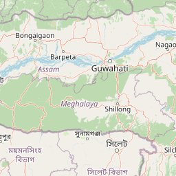
Geography guide, regional context, and park location map for Madhupur National Park

Madhupur National Park park geography, regions, and map view in Bangladesh
Understand where Madhupur National Park sits in Bangladesh through a broader geographic reading of the surrounding landscape, nearby location context, and its mapped position within the national park landscape.

How Madhupur National Park fits into Bangladesh

Bangladesh, officially the People's Republic of Bangladesh, is a South Asian country known for its high population density and deltaic geography formed by the Ganges-Brahmaputra river system. It gained independence from Pakistan in 1971 following a liberation war. The country operates as a unitary parliamentary republic with Dhaka as its capital and largest city, while Chittagong serves as the second-largest city and main port.

Wider geography shaping Madhupur National Park in Bangladesh

Bangladesh occupies the delta region at the confluence of the Ganges, Brahmaputra, and Meghna rivers in South Asia. The country shares land borders with India to the north, west, and east, and Myanmar to the southeast, while its southern boundary is along the Bay of Bengal. The terrain is predominantly low-lying deltaic plain, making it susceptible to flooding. The country is separated from Bhutan and Nepal by the Siliguri Corridor and from China by the Indian state of Sikkim.

Map view of Madhupur National Park

Use this park location map to pinpoint Madhupur National Park in Bangladesh, understand its exact geographic position, and read its mapped placement within the surrounding landscape more clearly.

Pigeon | © OpenStreetMap contributors

Location context for Madhupur National Park

Dhaka DivisionTangail District
Park atlas

Browse mapped protected landscapes and compare other conservation areas across the surrounding regional geography.

Explore Other National Parks and Protected Areas Near Madhupur National Park
After exploring Madhupur National Park, continue your geographic discovery by tracing other national parks and protected areas across Bangladesh and its surrounding landscapes. Compare protected landscapes, understand regional conservation patterns, and map the varied forest ecosystems or terrain that connect these natural areas.
National parkBhaluka Upazila

Kadigarh National Park National Park: Protected Landscape Atlas and Geographic Overview

Understand Kadigarh National Park's mapped boundaries and regional geography.

Kadigarh National Park is a distinct national park recognized for its protected status within Bhaluka Upazila, Bangladesh. This entry offers an atlas-centric perspective, detailing the park's geographic boundaries and its contribution to the regional landscape. Examine the mapped extent of this protected area and understand its role within the surrounding natural geography, providing a factual basis for exploring its protected landscape identity.

Area
3.441 km²
Established
2010
Climate
Tropical
Access
Easy access
National parkBangladesh

Bhawal National Park: Mapped Protected Landscape in Bangladesh

Explore its national park designation and regional geography.

Bhawal National Park represents a key protected landscape within Bangladesh. This entry provides detailed information on its identity as a national park, focusing on its mapped geography and protected area significance. Users can explore the park's specific context within the broader South Asian region, understanding its contribution to the nation's conserved natural areas and gaining insight into its landscape character through an atlas-driven perspective.

Area
50.22 km²
Established
1982
IUCN
IV
Relief
Lowland
Watercolor painting of rolling green hills, a meandering stream, and a soft pastel sky
National parkWest Garo Hills district

Nokrek National Park: Protected Mountain Landscape and Regional Geography

Explore its mapped boundaries and diverse natural terrain.

Nokrek National Park is a vital protected mountain wilderness situated in the West Garo Hills district, Meghalaya, India. Its rugged terrain, characterized by ancient geological formations and dense evergreen forests, supports remarkable biodiversity. As a key component of the Nokrek Biosphere Reserve, it offers a unique glimpse into the region's ecological significance, serving as an important source for major rivers and a sanctuary for diverse flora and fauna.

Area
47.48 km²
Established
1986
IUCN
II
Relief
Mountain
National parkBangladesh

Nawabganj National Park: Bangladesh National Park Geographic Identity and Atlas Exploration

Mapped boundaries and protected landscape context.

Delve into the detailed geographic profile of Nawabganj National Park, a protected national park located in Bangladesh. This resource facilitates an atlas-style discovery of its specific mapped boundaries and its contribution to the region's natural landscape character. Understand how this protected area fits within the broader context of South Asian geography and conservation.

Area
5.176 km²
Established
2010
IUCN
IV
Access
Easy access
Watercolor painting of a river flowing through a valley surrounded by hills and dense green vegetation
National parkNaogaon District

Altadighi National Park: Bangladesh's Protected Wetland Reserve in Naogaon District

Explore its mapped terrain and unique wetland ecosystem.

Altadighi National Park in Naogaon District, Bangladesh, is a protected nature reserve notable for its significant reservoir and wetland environment. Designated as a national park, it plays a crucial role in conserving a distinctive ecosystem within the country's protected landscape network. The park's geography, centered around its large water body, provides vital habitat and offers a unique subject for geographic and atlas-based discovery in northern Bangladesh, distinguishing it from more terrestrial protected areas.

Area
2.641 km²
Established
2011
IUCN
IV
Relief
Lowland
National parkHabiganj District

Satchari National Park: Mapped Protected Landscape in Habiganj District

Discover regional geography and park boundaries.

Satchari National Park represents a significant protected area within Bangladesh, situated in Habiganj District. This entry focuses on its identity as a national park, detailing its geographic footprint and landscape context. Explore the mapped dimensions of this protected land to better understand its role in the regional atlas and its specific natural terrain.

Area
2.43 km²
Established
2005
IUCN
II
Relief
Highland
Watercolor illustration showing a landscape with mountains, green fields, and a body of water
National parkDinajpur District

Ramsagar National Park: National Park Protected Area & Geographic Discovery

Explore mapped boundaries and regional landscape context.

Understand Ramsagar National Park as a protected national park within Dinajpur District, Bangladesh. This detail entry provides essential geographic context, outlining the park's mapped protected boundaries and its significance within the regional landscape. It serves as a foundational point for exploring the park's specific natural terrain and its place in a global atlas of conservation lands.

Area
0.278 km²
Established
2001
IUCN
IV
Relief
Lowland
National parkTripura

Clouded Leopard National Park: National Park Protected Area in Tripura's Forested Landscape

Mapped primate habitat and regional geography in Northeast India.

Clouded Leopard National Park serves as a critical protected area within Tripura, India, focusing on the conservation of its forest ecosystems and primate populations, including the Phayre's langur. As part of the larger Sepahijala Wildlife Sanctuary, its mapped boundaries contribute to the regional protected landscape. This national park offers valuable insight into the natural terrain and biodiversity specific to Northeast India, providing a unique geographic focus for atlas exploration.

Area
5.08 km²
Established
2007
IUCN
II
Climate
Tropical

Common questions about visiting, size, designation, and location context for Madhupur National Park

Madhupur National Park FAQs for park facts, access, geography, and protected area context
Find quick answers about Madhupur National Park, including protected-area facts, park geography, trail and visitor context, and how the park fits into its surrounding country and regional landscape.
MoriAtlas Explorer

Continue Your Protected Areas Search Across the Global Atlas

Deepen your exploration by continuing the structured search for national parks and protected areas worldwide. Utilize the comprehensive filtering capabilities to compare different conservation landscapes and refine your understanding of global park geography. Discover more about the distribution and characteristics of protected natural areas.

Global natural geography