Mori Atlas logo
National parkBhawal National Park

Understand the mapped boundaries and regional context of this key protected area in Bangladesh.

Bhawal National Park: Bangladesh's Protected Landscape & National Park Geography

Bhawal National Park stands as a significant protected area within Bangladesh, offering a unique lens through which to understand the nation's geography and conservation landscapes. As a designated national park, its protected boundaries provide a distinct geographic focus for exploration. This page delves into the mapped terrain and regional context of Bhawal National Park, aiding in the discovery of its specific place within the South Asian landscape and its role as a key natural area.

Sal forestProtected forestIUCN Category IVWildlife sanctuaryBangladeshi national parkForest conservation

Bhawal National Park

National park

Park overview

Structured park overview, official facts, and landscape profile for Bhawal National Park

Bhawal National Park park facts, protected area profile, and essential visitor context
Review the core facts for Bhawal National Park, including designation, size, terrain, visitor scale, habitats, and operating context in one park-focused overview.

About Bhawal National Park

Bhawal National Park occupies a significant position in Bangladesh's protected area system as a remnant of the extensive sal forests that once covered the Madhupur tract in central Bangladesh. The park is located in Gazipur District within Dhaka Division, positioned roughly 40 kilometers north of Bangladesh's capital city and approximately 20 kilometers from both Gazipur town and Kapasia Upazila. The protected area was formally established under the Wildlife Act of 1974 and officially declared as a national park in 1982, though its forest lands have historical significance dating back to the Bhawal Estate period. The park encompasses 5,022 hectares of land, of which 940 hectares constitute the core protected zone. The surrounding areas have been subject to significant human pressure, with much of the former forest land now occupied by forestry plantations and settlements of displaced people. This pressure has fundamentally altered the ecological character of the region, though the park still retains important conservation value as a living example of Bangladesh's forest heritage.

Quick facts and research context for Bhawal National Park

Bhawal National Park spans 5,022 hectares in Gazipur District, Dhaka Division, Bangladesh, located approximately 40 kilometers north of Dhaka. The park was officially designated in 1982 under Bangladesh's Wildlife Act of 1974, though it had been managed as a national park since 1974. It sits within the former Bhawal Estate forest lands and contains a core area of 940 hectares. The ecosystem is characterized by coppice sal forest, once the dominant forest type across much of central Bangladesh. The park is classified under IUCN Category IV for habitat and species management, with elements of Category V for protected landscape. The area has suffered substantial ecological degradation, with much of the original sal forest cleared for forestry plantations and human settlement.

Park context

Deeper park guide and search-rich context for Bhawal National Park

Bhawal National Park history, landscape, wildlife, and travel context
Explore Bhawal National Park through its history, landscape character, ecosystems, wildlife, conservation priorities, cultural context, and seasonal travel timing in a structured park guide built for atlas discovery and search intent.

Why Bhawal National Park stands out

Bhawal National Park is best known as one of the last remaining fragments of sal forest in Bangladesh, representing a rapidly vanishing ecosystem type that once covered vast areas of the country's central plains. The park preserves what remains of the sal-dominated woodland that characterized the Madhupur region under the historic Bhawal Estate. Once home to impressive wildlife including Bengal tigers, leopards, elephants, and clouded leopards, the park has become emblematic of both the ecological richness that once existed in this region and the conservation challenges facing Bangladesh's natural landscapes. The remaining sal trees and the park's proximity to Dhaka make it a significant site for environmental education and awareness.

Bhawal National Park history and protected-area timeline

The land that now comprises Bhawal National Park carries a heritage linked to the Bhawal Estate, a significant historical landholding in central Bangladesh during the colonial and post-colonial periods. The forest area was originally part of the Madhupur forest tract, which contained extensive stands of sal (Shorea robusta), the economically and ecologically important tree species that dominated forests across much of the Bengal region. The area was formally designated as a national park in 1974 and received official declaration under the Wildlife Act of 1974 in 1982, establishing its protected status within Bangladesh's legal framework. The park's management falls under IUCN Category V as a protected landscape, reflecting its dual function of habitat protection and providing opportunities for public recreation. Within the past fifty years, the ecological character of the region has transformed dramatically, with illegal deforestation reducing the original forest cover dramatically. The forest department has undertaken reforestation efforts, though these have primarily involved plantation species rather than restoration of the original sal forest ecosystem. The park's historical wildlife population, which once included tigers, leopards, black panthers, elephants, clouded leopards, and sambar deer, has been drastically reduced, with only a few species now remaining in the area.

Bhawal National Park landscape and geographic character

The landscape of Bhawal National Park is characterized by gently undulating terrain typical of the Madhupur plateau in central Bangladesh. The area features a mix of flatlands and low ridges, with the terrain generally not exceeding modest elevations. The park's setting within the former Bhawal Estate lands means that the landscape bears the imprint of both natural forest and historical human management. The soil conditions support the growth of sal forest, which thrives on the well-drained soils of the region. The park contains areas of natural forest remaining among more heavily modified plantation areas, creating a mosaic landscape that reflects both historical forest cover and subsequent human modification. Water features within the park contribute to the ecological diversity, with views of valleys and rivers available from elevated points within the protected area. The contrast between the remaining old-growth sal areas and the newer plantation zones illustrates the ecological transition the park has undergone.

Bhawal National Park ecosystems, habitats, and plant life

The ecological character of Bhawal National Park centers on its sal forest ecosystem, which represents one of the most threatened forest types in Bangladesh. The park contains approximately 345 plant species, including 151 different tree species, 53 shrubs, 106 herbs, and 34 climber species. The sal tree (Shorea robusta) remains the dominant species, representing the coppice forest formation that characterizes this ecosystem type. This forest type once covered extensive areas of Bangladesh's central plains but has been drastically reduced through clearing for agriculture, timber extraction, and human settlement. The park's remaining natural areas provide habitat for species adapted to sal forest conditions, though the overall biodiversity has been significantly reduced from historical levels. The park represents a refuge for forest-dependent species in a region where natural forest cover has become extremely limited, making its continued protection important for maintaining ecological connectivity and genetic diversity for forest species.

Bhawal National Park wildlife and species highlights

The wildlife community of Bhawal National Park has experienced substantial decline from its historical baseline, reflecting the broader pattern of biodiversity loss across Bangladesh's forested areas. Historically, the park supported an impressive array of large mammals including Bengal tigers, leopards, black panthers, Asian elephants, clouded leopards, and sambar deer. Peacocks were also noted as common inhabitants of the area. The current wildlife population is considerably reduced, with the park now supporting 13 mammal species, 9 reptile species, 5 bird species, and 5 amphibian species. The Forest Department has undertaken restocking efforts, introducing peacocks, deer, pythons, and catfish to supplement the remaining wildlife populations. The Bengal monitor represents one of the notable reptile species still present in the park. The contrast between the historical wildlife accounts and the present situation illustrates the severity of habitat loss and fragmentation that has affected this region, while also highlighting the importance of maintaining what remaining populations exist.

Bhawal National Park conservation status and protection priorities

Bhawal National Park represents both the challenges and the importance of forest conservation in Bangladesh. The park is designated under IUCN Management Category IV as a habitat and species management area, reflecting its focus on maintaining viable populations of native species within the sal forest ecosystem. The protected landscape designation under Category V acknowledges the park's cultural and scenic values alongside its ecological function. The park faces significant conservation challenges, including ongoing habitat degradation from illegal deforestation, encroachment by human settlements, and competition from commercial forestry operations. The reduction of original sal forest from what was once extensive coverage to approximately 600 square kilometers across the region demonstrates the scale of ecological loss that has occurred. Conservation efforts at the park focus on protecting the remaining forest areas, managing the introduced wildlife populations, and providing environmental education opportunities for visitors. The park's proximity to Dhaka gives it particular value as an accessible site for connecting urban populations with natural environments and raising awareness about conservation needs.

Bhawal National Park cultural meaning and human context

The lands of Bhawal National Park are historically connected to the Bhawal Estate, a significant historical landholding in the region that dates to the colonial period in Bangladesh. The estate managed extensive forest and agricultural lands in the Madhupur region, and the forest areas within what is now the park formed part of this historical land use system. The name Bhawal derives from this estate connection, and the park preserves the memory of a landscape that was once heavily managed but also retained significant natural value. The region has experienced substantial demographic changes over recent decades, with population growth and development pressure transforming much of the surrounding landscape. The park represents a cultural as well as ecological space, linking contemporary conservation efforts with the historical land management traditions of the region.

Top sights and standout views in Bhawal National Park

Bhawal National Park stands as one of Bangladesh's last remaining sal forest ecosystems, offering visitors the opportunity to experience a forest type that once dominated the country's central plains but now exists in only fragmented remnants. The park's location within easy reach of Dhaka makes it an important site for environmental education and nature-based recreation for the capital's residents. The remaining sal trees, though reduced from historical extent, provide a sense of the original forest character that characterized this region. The presence of introduced species including peacocks and deer, alongside the native wildlife that persists, offers wildlife viewing opportunities within a managed protected area setting. The park's role in preserving genetic material and ecological function for forest-dependent species gives it conservation significance beyond its relatively modest size.

Best time to visit Bhawal National Park

The optimal time to visit Bhawal National Park falls during the cooler months from November through March, when temperatures are more comfortable for outdoor exploration and the risk of heavy rainfall is reduced. The winter months offer pleasant conditions for walking through the forest trails and observing wildlife, though visitors should be prepared for morning and evening coolness. The monsoon season from June to September brings heavy rainfall to the region, which can limit access to some park areas and make outdoor activities less comfortable. The period from April through May tends to be hot and humid, with temperatures rising significantly, which can make park visits challenging during midday hours. Visitors interested in birdwatching may find the post-monsoon period particularly rewarding as migratory bird species pass through the area.

Park location guide

Geography guide, regional context, and park location map for Bhawal National Park

Bhawal National Park park geography, regions, and map view in Bangladesh
Understand where Bhawal National Park sits in Bangladesh through a broader geographic reading of the surrounding landscape, nearby location context, and its mapped position within the national park landscape.

How Bhawal National Park fits into Bangladesh

Bangladesh, officially the People's Republic of Bangladesh, is a South Asian country known for its high population density and deltaic geography formed by the Ganges-Brahmaputra river system. It gained independence from Pakistan in 1971 following a liberation war. The country operates as a unitary parliamentary republic with Dhaka as its capital and largest city, while Chittagong serves as the second-largest city and main port.

Wider geography shaping Bhawal National Park in Bangladesh

Bangladesh occupies the delta region at the confluence of the Ganges, Brahmaputra, and Meghna rivers in South Asia. The country shares land borders with India to the north, west, and east, and Myanmar to the southeast, while its southern boundary is along the Bay of Bengal. The terrain is predominantly low-lying deltaic plain, making it susceptible to flooding. The country is separated from Bhutan and Nepal by the Siliguri Corridor and from China by the Indian state of Sikkim.

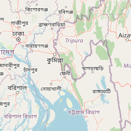
Map view of Bhawal National Park

Use this park location map to pinpoint Bhawal National Park in Bangladesh, understand its exact geographic position, and read its mapped placement within the surrounding landscape more clearly.

Pigeon | © OpenStreetMap contributors

Location context for Bhawal National Park

Dhaka Division
Park atlas

Explore mapped geography and compare adjacent protected landscapes across the Madhupur plateau region of Bangladesh.

Discover Other National Parks and Protected Areas Surrounding Bhawal National Park
After exploring Bhawal National Park, you can trace the regional spread of other national parks and protected natural areas that share similar sal forest ecosystems and conservation challenges. Compare the geographic context of these vital conservation landscapes, understanding their distribution and significance within Bangladesh's central plains for continued atlas-style discovery.
National parkBhaluka Upazila

Kadigarh National Park National Park: Protected Landscape Atlas and Geographic Overview

Understand Kadigarh National Park's mapped boundaries and regional geography.

Kadigarh National Park is a distinct national park recognized for its protected status within Bhaluka Upazila, Bangladesh. This entry offers an atlas-centric perspective, detailing the park's geographic boundaries and its contribution to the regional landscape. Examine the mapped extent of this protected area and understand its role within the surrounding natural geography, providing a factual basis for exploring its protected landscape identity.

Area
3.441 km²
Established
2010
Climate
Tropical
Access
Easy access
National parkTangail District

Madhupur National Park: Protected Landscape and Geographic Context

Explore its mapped boundaries within Tangail District.

Delve into the protected landscape of Madhupur National Park, a national park located in Tangail District. This resource provides critical geographic context, detailing the park's mapped boundaries and its role as a protected natural area. Understand its placement within the regional geography for a deeper appreciation of Bangladesh's conservation landscapes.

Area
84.36 km²
Established
1982
IUCN
II
Relief
Lowland
National parkTripura

Clouded Leopard National Park: National Park Protected Area in Tripura's Forested Landscape

Mapped primate habitat and regional geography in Northeast India.

Clouded Leopard National Park serves as a critical protected area within Tripura, India, focusing on the conservation of its forest ecosystems and primate populations, including the Phayre's langur. As part of the larger Sepahijala Wildlife Sanctuary, its mapped boundaries contribute to the regional protected landscape. This national park offers valuable insight into the natural terrain and biodiversity specific to Northeast India, providing a unique geographic focus for atlas exploration.

Area
5.08 km²
Established
2007
IUCN
II
Climate
Tropical
National parkHabiganj District

Satchari National Park: Mapped Protected Landscape in Habiganj District

Discover regional geography and park boundaries.

Satchari National Park represents a significant protected area within Bangladesh, situated in Habiganj District. This entry focuses on its identity as a national park, detailing its geographic footprint and landscape context. Explore the mapped dimensions of this protected land to better understand its role in the regional atlas and its specific natural terrain.

Area
2.43 km²
Established
2005
IUCN
II
Relief
Highland
National parkMoulvibazar District

Lawachara National Park: Protected National Park Landscape in Moulvibazar District

Mapped Terrain and Endangered Primate Habitat Exploration

Delve into the protected landscape of Lawachara National Park, a key national park located in the distinct undulating terrain of Moulvibazar District, Bangladesh. This area is recognized for its ecological significance, particularly as a sanctuary for endangered primates, including the critically important western hoolock gibbon population. Users can explore the park's mapped boundaries, understand its semi-evergreen forest ecosystem, and appreciate its geological features like sandstone hillocks and sandy-bedded streams, making it a valuable point of discovery for regional geography and conservation landscapes.

Area
12.5 km²
Established
1996
IUCN
II
Relief
Upland
Watercolor painting of rolling green hills, a meandering stream, and a soft pastel sky
National parkWest Garo Hills district

Nokrek National Park: Protected Mountain Landscape and Regional Geography

Explore its mapped boundaries and diverse natural terrain.

Nokrek National Park is a vital protected mountain wilderness situated in the West Garo Hills district, Meghalaya, India. Its rugged terrain, characterized by ancient geological formations and dense evergreen forests, supports remarkable biodiversity. As a key component of the Nokrek Biosphere Reserve, it offers a unique glimpse into the region's ecological significance, serving as an important source for major rivers and a sanctuary for diverse flora and fauna.

Area
47.48 km²
Established
1986
IUCN
II
Relief
Mountain
Watercolor painting showing grasses in the foreground, a body of water, and hilly terrain under a pale sky
National parkSylhet District

Khadim Nagar National Park: Bangladesh National Park with Sylhet District Geographic Context

Mapped protected landscape and regional park identity.

Khadim Nagar National Park stands as a significant national park within Sylhet District, Bangladesh, offering a focused point for understanding protected land distribution and geographic features. This entry serves as a resource for exploring the park's specific boundaries and its role within the larger atlas of natural landscapes. Users can gain a clear view of its protected status and its place within the regional geography, facilitating detailed park exploration.

Area
6.79 km²
Established
2006
IUCN
II
Relief
Mixed relief
Watercolor painting of a river flowing through a valley surrounded by hills and dense green vegetation
National parkNaogaon District

Altadighi National Park: Bangladesh's Protected Wetland Reserve in Naogaon District

Explore its mapped terrain and unique wetland ecosystem.

Altadighi National Park in Naogaon District, Bangladesh, is a protected nature reserve notable for its significant reservoir and wetland environment. Designated as a national park, it plays a crucial role in conserving a distinctive ecosystem within the country's protected landscape network. The park's geography, centered around its large water body, provides vital habitat and offers a unique subject for geographic and atlas-based discovery in northern Bangladesh, distinguishing it from more terrestrial protected areas.

Area
2.641 km²
Established
2011
IUCN
IV
Relief
Lowland

Common questions about visiting, size, designation, and location context for Bhawal National Park

Bhawal National Park FAQs for park facts, access, geography, and protected area context
Find quick answers about Bhawal National Park, including protected-area facts, park geography, trail and visitor context, and how the park fits into its surrounding country and regional landscape.
MoriAtlas Explorer

Continue Your Protected Areas Search Across the Global Atlas

Deepen your exploration by continuing the structured search for national parks and protected areas worldwide. Utilize the comprehensive filtering capabilities to compare different conservation landscapes and refine your understanding of global park geography. Discover more about the distribution and characteristics of protected natural areas.

Global natural geography