Mori Atlas logo
National parkKadigarh National Park

Discover the protected landscape identity and geographic setting of Kadigarh National Park.

Kadigarh National Park National Park: Mapped Boundaries and Regional Geographic Context

Kadigarh National Park stands as a designated national park within the Bhaluka Upazila region of Bangladesh. This page provides an atlas-focused view of Kadigarh National Park, detailing its protected area status and its place within the local geography. Users can explore its mapped boundaries, understand its natural landscape context, and gain insight into its significance as a protected zone within the broader regional geography.

national parksal foresthardwood forestprotected areaMymensingh DivisionBangladeshi wildlife

Kadigarh National Park

National park

Park overview

Structured park overview, official facts, and landscape profile for Kadigarh National Park

Kadigarh National Park park facts, protected area profile, and essential visitor context
Review the core facts for Kadigarh National Park, including designation, size, terrain, visitor scale, habitats, and operating context in one park-focused overview.

About Kadigarh National Park

Kadigarh National Park is a protected natural area established in 2010 in the Mymensingh district of Bangladesh. The park covers 344.13 hectares of land characterized primarily by sal forest vegetation, a forest type dominated by Shorea robusta trees that once formed extensive forests across the Ganges-Brahmaputra delta region. The park is situated in Bhaluka Upazila, approximately 1 kilometer north of Kachina Bazaar along the road connecting Siddhastor Bazaar to Sakhipur. The surrounding landscape is dominated by agricultural land and human settlements, with villages including Kachina, Palgaon, Tamat, and Dhakuria located near the park boundaries. This setting makes the park an important ecological island within a heavily modified agricultural landscape, providing habitat for forest-dependent species and preserving a remnant of the region's original forest character. The park includes basic visitor infrastructure such as a rest house, allowing for limited recreational and educational access to the protected area.

Quick facts and research context for Kadigarh National Park

Kadigarh National Park occupies 344.13 hectares in Bhaluka Upazila, Mymensingh Division, in central Bangladesh. The park was designated as a national park in October 2010, making it a relatively recent addition to Bangladesh's protected area network. The landscape is characterized by sal forest, a dominant forest type in the region. The park is situated near several villages including Kachina, Palgaon, and nearby settlements. The geographic coordinates place the park at approximately 24.338429°N latitude and 90.328393°E longitude.

Park context

Deeper park guide and search-rich context for Kadigarh National Park

Kadigarh National Park history, landscape, wildlife, and travel context
Explore Kadigarh National Park through its history, landscape character, ecosystems, wildlife, conservation priorities, cultural context, and seasonal travel timing in a structured park guide built for atlas discovery and search intent.

Why Kadigarh National Park stands out

Kadigarh National Park is best known for its sal forest ecosystem, a distinctive hardwood forest type that once covered much of the Bengal delta region but now exists only in fragmented patches. The park provides protected habitat for bird species including the Indian Pitta, a colorful and visually striking songbird that inhabits forest understories. The park represents one of the few remaining forested areas in the heavily cultivated Mymensingh district, serving as a refuge for wildlife in a region where natural forest cover has been substantially diminished. Its location in Bhaluka Upazila places it within an area of transitioning landscape character between more forested northern regions and the intensive rice cultivation zones of central Bangladesh.

Kadigarh National Park history and protected-area timeline

Kadigarh National Park was officially established on October 24, 2010, making it one of the more recent additions to Bangladesh's national park system. The designation came as part of ongoing efforts by the Government of Bangladesh to expand protected area coverage and preserve remaining natural ecosystems in the country. The establishment of the park reflected recognition of the ecological value of remaining sal forest patches in the Mymensingh region, an area that has experienced substantial forest loss due to agricultural expansion and human settlement over the past several decades. The park's creation followed broader national trends toward designating new protected areas to meet biodiversity conservation targets and maintain ecological services in heavily populated regions of Bangladesh.

Kadigarh National Park landscape and geographic character

The landscape of Kadigarh National Park is characterized by flat to gently undulating terrain typical of the Ganges delta region. The terrain consists primarily of alluvial soils deposited by the rivers flowing through central Bangladesh, with elevation remaining relatively low throughout the area. The park's vegetation is dominated by sal forest, a semi-deciduous hardwood forest type adapted to the subtropical climate of the region. The forest canopy is primarily composed of sal trees, with an understory of smaller trees, shrubs, and herbaceous plants typical of tropical and subtropical forest ecosystems. The area's hydrology is influenced by seasonal monsoon patterns, with wet and dry seasons creating distinct environmental conditions throughout the year.

Kadigarh National Park ecosystems, habitats, and plant life

Kadigarh National Park represents a remnant sal forest ecosystem in a region where such forests have been largely converted to agricultural land. The sal forest type is characterized by Shorea robusta as the dominant tree species, forming a dense canopy during the monsoon season and partially losing leaves during the dry winter months. This forest type once covered extensive areas of the Bengal basin but now exists in fragmented patches throughout Bangladesh and neighboring regions. The park provides protected habitat for forest-dwelling species and helps maintain ecological processes in an area where natural ecosystems have been significantly altered. The forest supports biodiversity including bird species, insect communities, and smaller mammals that depend on forested habitat for survival.

Kadigarh National Park wildlife and species highlights

The wildlife of Kadigarh National Park includes bird species such as the Indian Pitta, a colorful ground-dwelling bird that inhabits the forest floor and understory layers. The Indian Pitta is known for its vibrant plumage featuring blue, green, yellow, and red coloration, and is a species that migrates through the Indian subcontinent. The sal forest environment supports a variety of bird species, insects, and smaller fauna adapted to forest habitats. While detailed species inventories are not fully documented in available sources, the park's protected forest habitat provides essential breeding and foraging grounds for wildlife in a region where natural forest cover is limited.

Kadigarh National Park conservation status and protection priorities

Kadigarh National Park faces significant conservation challenges from illegal logging and encroachment. Sawmills have been established illegally in surrounding villages in violation of Forest Department regulations, actively logging large sal trees from the forest both during daylight and at night. The illegally harvested timber is subsequently sold to furniture shops in nearby markets. This logging activity represents a direct threat to the park's forest ecosystem and the biodiversity it supports. The park's location within a densely populated agricultural region makes it particularly vulnerable to such pressures, as surrounding communities depend on forest resources and land use pressures remain high. Conservation effectiveness depends on enforcement of forest protection regulations and sustainable management of the surrounding landscape.

Top sights and standout views in Kadigarh National Park

Kadigarh National Park protects one of the remaining patches of sal forest in the Mymensingh region of Bangladesh. The park's establishment in 2010 reflects ongoing conservation efforts in a country with limited forest cover. The Indian Pitta and other bird species inhabit the park's forest understory. The park offers basic visitor facilities including a rest house. The park sits within an agricultural landscape, making it an important ecological refuge in a heavily modified region. Conservation challenges include illegal logging by sawmills operating in surrounding villages.

Park location guide

Geography guide, regional context, and park location map for Kadigarh National Park

Kadigarh National Park park geography, regions, and map view in Bangladesh
Understand where Kadigarh National Park sits in Bangladesh through a broader geographic reading of the surrounding landscape, nearby location context, and its mapped position within the national park landscape.

How Kadigarh National Park fits into Bangladesh

Bangladesh, officially the People's Republic of Bangladesh, is a South Asian country known for its high population density and deltaic geography formed by the Ganges-Brahmaputra river system. It gained independence from Pakistan in 1971 following a liberation war. The country operates as a unitary parliamentary republic with Dhaka as its capital and largest city, while Chittagong serves as the second-largest city and main port.

Wider geography shaping Kadigarh National Park in Bangladesh

Bangladesh occupies the delta region at the confluence of the Ganges, Brahmaputra, and Meghna rivers in South Asia. The country shares land borders with India to the north, west, and east, and Myanmar to the southeast, while its southern boundary is along the Bay of Bengal. The terrain is predominantly low-lying deltaic plain, making it susceptible to flooding. The country is separated from Bhutan and Nepal by the Siliguri Corridor and from China by the Indian state of Sikkim.

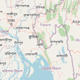
Map view of Kadigarh National Park

Use this park location map to pinpoint Kadigarh National Park in Bangladesh, understand its exact geographic position, and read its mapped placement within the surrounding landscape more clearly.

Pigeon | © OpenStreetMap contributors

Location context for Kadigarh National Park

Bhaluka UpazilaMymensingh DistrictMymensingh Division
Park atlas

Trace the regional spread of national parks and protected landscapes around Kadigarh National Park, comparing distinct conservation efforts.

Discover More National Parks and Protected Areas Near Kadigarh, Bangladesh
Explore an curated selection of national parks and protected areas situated geographically near Kadigarh National Park, revealing the diverse conservation landscapes of central Bangladesh. This atlas view allows for direct comparison of the sal forest ecosystem with other regional protected habitats, enhancing your understanding of area-specific biodiversity and conservation efforts.
National parkBangladesh

Bhawal National Park: Mapped Protected Landscape in Bangladesh

Explore its national park designation and regional geography.

Bhawal National Park represents a key protected landscape within Bangladesh. This entry provides detailed information on its identity as a national park, focusing on its mapped geography and protected area significance. Users can explore the park's specific context within the broader South Asian region, understanding its contribution to the nation's conserved natural areas and gaining insight into its landscape character through an atlas-driven perspective.

Area
50.22 km²
Established
1982
IUCN
IV
Relief
Lowland
National parkTangail District

Madhupur National Park: Protected Landscape and Geographic Context

Explore its mapped boundaries within Tangail District.

Delve into the protected landscape of Madhupur National Park, a national park located in Tangail District. This resource provides critical geographic context, detailing the park's mapped boundaries and its role as a protected natural area. Understand its placement within the regional geography for a deeper appreciation of Bangladesh's conservation landscapes.

Area
84.36 km²
Established
1982
IUCN
II
Relief
Lowland
National parkHabiganj District

Satchari National Park: Mapped Protected Landscape in Habiganj District

Discover regional geography and park boundaries.

Satchari National Park represents a significant protected area within Bangladesh, situated in Habiganj District. This entry focuses on its identity as a national park, detailing its geographic footprint and landscape context. Explore the mapped dimensions of this protected land to better understand its role in the regional atlas and its specific natural terrain.

Area
2.43 km²
Established
2005
IUCN
II
Relief
Highland
National parkTripura

Clouded Leopard National Park: National Park Protected Area in Tripura's Forested Landscape

Mapped primate habitat and regional geography in Northeast India.

Clouded Leopard National Park serves as a critical protected area within Tripura, India, focusing on the conservation of its forest ecosystems and primate populations, including the Phayre's langur. As part of the larger Sepahijala Wildlife Sanctuary, its mapped boundaries contribute to the regional protected landscape. This national park offers valuable insight into the natural terrain and biodiversity specific to Northeast India, providing a unique geographic focus for atlas exploration.

Area
5.08 km²
Established
2007
IUCN
II
Climate
Tropical
Watercolor painting of rolling green hills, a meandering stream, and a soft pastel sky
National parkWest Garo Hills district

Nokrek National Park: Protected Mountain Landscape and Regional Geography

Explore its mapped boundaries and diverse natural terrain.

Nokrek National Park is a vital protected mountain wilderness situated in the West Garo Hills district, Meghalaya, India. Its rugged terrain, characterized by ancient geological formations and dense evergreen forests, supports remarkable biodiversity. As a key component of the Nokrek Biosphere Reserve, it offers a unique glimpse into the region's ecological significance, serving as an important source for major rivers and a sanctuary for diverse flora and fauna.

Area
47.48 km²
Established
1986
IUCN
II
Relief
Mountain
National parkMoulvibazar District

Lawachara National Park: Protected National Park Landscape in Moulvibazar District

Mapped Terrain and Endangered Primate Habitat Exploration

Delve into the protected landscape of Lawachara National Park, a key national park located in the distinct undulating terrain of Moulvibazar District, Bangladesh. This area is recognized for its ecological significance, particularly as a sanctuary for endangered primates, including the critically important western hoolock gibbon population. Users can explore the park's mapped boundaries, understand its semi-evergreen forest ecosystem, and appreciate its geological features like sandstone hillocks and sandy-bedded streams, making it a valuable point of discovery for regional geography and conservation landscapes.

Area
12.5 km²
Established
1996
IUCN
II
Relief
Upland
Watercolor painting of a river flowing through a valley surrounded by hills and dense green vegetation
National parkNaogaon District

Altadighi National Park: Bangladesh's Protected Wetland Reserve in Naogaon District

Explore its mapped terrain and unique wetland ecosystem.

Altadighi National Park in Naogaon District, Bangladesh, is a protected nature reserve notable for its significant reservoir and wetland environment. Designated as a national park, it plays a crucial role in conserving a distinctive ecosystem within the country's protected landscape network. The park's geography, centered around its large water body, provides vital habitat and offers a unique subject for geographic and atlas-based discovery in northern Bangladesh, distinguishing it from more terrestrial protected areas.

Area
2.641 km²
Established
2011
IUCN
IV
Relief
Lowland
National parkBangladesh

Nawabganj National Park: Bangladesh National Park Geographic Identity and Atlas Exploration

Mapped boundaries and protected landscape context.

Delve into the detailed geographic profile of Nawabganj National Park, a protected national park located in Bangladesh. This resource facilitates an atlas-style discovery of its specific mapped boundaries and its contribution to the region's natural landscape character. Understand how this protected area fits within the broader context of South Asian geography and conservation.

Area
5.176 km²
Established
2010
IUCN
IV
Access
Easy access

Common questions about visiting, size, designation, and location context for Kadigarh National Park

Kadigarh National Park FAQs for park facts, access, geography, and protected area context
Find quick answers about Kadigarh National Park, including protected-area facts, park geography, trail and visitor context, and how the park fits into its surrounding country and regional landscape.
MoriAtlas Explorer

Continue Your Protected Areas Search Across the Global Atlas

Deepen your exploration by continuing the structured search for national parks and protected areas worldwide. Utilize the comprehensive filtering capabilities to compare different conservation landscapes and refine your understanding of global park geography. Discover more about the distribution and characteristics of protected natural areas.

Global natural geography