Mori Atlas logo
National parkBalphakram National Park

Discover the mapped boundaries and regional landscape context of this protected area.

Balphakram National Park: National Park Protected Landscape & Geography

Balphakram National Park represents a significant protected landscape within India, offering a unique geographic identity for atlas-based discovery. This page provides an entry point to understanding the park's specific mapped boundaries, its role as a national park, and the surrounding natural terrain that defines its regional context. Explore how this protected area fits into the broader geography, providing essential context for detailed landscape analysis and protected lands exploration.

IndiaNational ParkMeghalayaNortheast IndiaEast Khasi HillsProtected Area

Balphakram National Park

National park

Park overview

Structured park overview, official facts, and landscape profile for Balphakram National Park

Balphakram National Park park facts, protected area profile, and essential visitor context

Review the core facts for Balphakram National Park, including designation, size, terrain, visitor scale, habitats, and operating context in one park-focused overview.

About Balphakram National Park

Balphakram National Park represents one of the protected natural areas within Meghalaya, a northeastern Indian state renowned for its mountainous terrain, abundant rainfall, and distinctive ecosystems. The park occupies a position within the East Khasi Hills, an area of significant topographic variation where the landscape transitions from steep slopes to more gentle undulating terrain. The region's proximity to the Bangladesh border gives it strategic importance within the broader network of Indian protected areas along the international boundary. Meghalaya's environment is shaped by its position at the edge of the monsoon belt, supporting forests, grasslands, and diverse habitats that contrast with the more arid landscapes found in other parts of the Indian subcontinent.

Quick facts and research context for Balphakram National Park

Balphakram National Park is located in East Khasi Hills, Meghalaya, India, in the northeastern region of the country. The area features the characteristic hilly terrain of the Khasi Hills, with elevation changes and forested environments. The park is situated near the international border with Bangladesh. Meghalaya state is known for its tribal populations, particularly the Khasi people, who have traditional connections to the landscape surrounding the park.

Park context

Deeper park guide and search-rich context for Balphakram National Park

Balphakram National Park history, landscape, wildlife, and travel context

Explore Balphakram National Park through its history, landscape character, ecosystems, wildlife, conservation priorities, cultural context, and seasonal travel timing in a structured park guide built for atlas discovery and search intent.

Balphakram National Park landscape and geographic character

The park is set within the Khasi Hills region of Meghalaya, characterized by laterite plateaus, rolling uplands, and valleys carved by seasonal streams. The terrain reflects the geological character of the Shillong Plateau, with elevation changes that create diverse microhabitats within the protected area. Vegetation transitions from dense forest cover in valley areas to more open slopes, consistent with the mixed deciduous and evergreen forest patterns found throughout the Meghalayan highlands.

Balphakram National Park cultural meaning and human context

The park exists within a landscape shaped by centuries of Khasi tribal habitation and traditional land use. The Khasi people, one of the major tribal communities of Meghalaya, maintain deep cultural connections to the hills and forests of the region. Their traditional governance systems and relationship with the land have influenced how conservation areas are perceived and managed in contemporary contexts.
Monthly climate preview

Long-term monthly temperature and precipitation patterns recorded at a representative point

Balphakram National Park Climate Normals and Annual Temperature Rhythm

Representative coordinates document sustained thermal shifts and distinct monthly precipitation cycles across the protected terrain. Comprehensive data breakdowns reveal complete twelve-month temperature averages and precipitation metrics for analytical review.
Annual mean23 °C
16 °C27 °C
Jan16°
Feb19°
Mar24°
Apr26°
May27°
Jun27°
Jul27°
Aug27°
Sep26°
Oct24°
Nov20°
Dec17°
Warmest month
June

27.2 °C

Coolest month
January

15.8 °C

Wettest month
June

13.4 mm/day

Driest month
December

0.3 mm/day

Park location guide

Geography guide, regional context, and park location map for Balphakram National Park

Balphakram National Park park geography, regions, and map view in India

Understand where Balphakram National Park sits in India through a broader geographic reading of the surrounding landscape, nearby location context, and its mapped position within the national park landscape.

How Balphakram National Park fits into India

India is a South Asian country bordered by the Indian Ocean, Arabian Sea, and Bay of Bengal. It shares land borders with Pakistan, China, Nepal, Bhutan, Bangladesh, and Myanmar. The country has a population of over 1.4 billion people and operates as a federal parliamentary republic with its capital in New Delhi.

Wider geography shaping Balphakram National Park in India

India occupies the Indian subcontinent in South Asia, bordered by the Arabian Sea to the southwest, the Bay of Bengal to the southeast, and the Indian Ocean to the south. It shares land borders with Pakistan to the west, China, Nepal, and Bhutan to the north, and Bangladesh and Myanmar to the east. The territory also includes the Andaman and Nicobar Islands in the Indian Ocean.

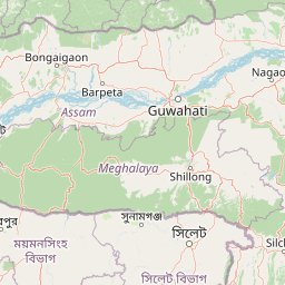
Map view of Balphakram National Park

Use this park location map to pinpoint Balphakram National Park in India, understand its exact geographic position, and read its mapped placement within the surrounding landscape more clearly.

Pigeon | © OpenStreetMap contributors
Park atlas

Trace the broader geographic spread of conservation landscapes across India's Meghalaya plateau and its distinct Northeast region.

Explore Other National Parks and Protected Areas Near Balphakram National Park

Continue your protected area exploration by browsing national parks and wildlife sanctuaries geographically close to Balphakram National Park within India's distinct Northeast region. This expanded view allows for deeper comparison of varied terrain, conservation landscapes, and regional park distribution across Meghalaya and its adjacent territories.
Watercolor painting of rolling green hills, a meandering stream, and a soft pastel sky
National parkWest Garo Hills district
About 77 km away#1 closest

West

Nokrek National Park: Protected Mountain Landscape and Regional Geography

Explore its mapped boundaries and diverse natural terrain.

Nokrek National Park is a vital protected mountain wilderness situated in the West Garo Hills district, Meghalaya, India. Its rugged terrain, characterized by ancient geological formations and dense evergreen forests, supports remarkable biodiversity. As a key component of the Nokrek Biosphere Reserve, it offers a unique glimpse into the region's ecological significance, serving as an important source for major rivers and a sanctuary for diverse flora and fauna.

Area
47.48 km²
Established
1986
IUCN
II
Relief
Mountain
National parkTangail District
About 108 km away#2 closest

Southwest

Madhupur National Park: Protected Landscape and Geographic Context

Explore its mapped boundaries within Tangail District.

Delve into the protected landscape of Madhupur National Park, a national park located in Tangail District. This resource provides critical geographic context, detailing the park's mapped boundaries and its role as a protected natural area. Understand its placement within the regional geography for a deeper appreciation of Bangladesh's conservation landscapes.

Area
84.36 km²
Established
1982
IUCN
II
Relief
Lowland
Wildlife reserveAssam
About 115 km away#3 closest

Northwest

Chakrashila Wildlife Sanctuary: Geography, Mapped Terrain, and Assam Protected Landscapes

A vital wildlife reserve within the Brahmaputra foothills

Chakrashila Wildlife Sanctuary represents a key ecological link in western Assam, characterized by its mix of sal-dominated hill forests and two significant freshwater wetlands, Dheer Beel and Diplai Beel. This compact reserve offers a distinct topographical study of the Brahmaputra foothills and remains a central point for understanding primate-focused habitat preservation in the region.

Area
45.568 km²
Established
1994
IUCN
IV
Water
Major water bodies
Watercolor painting showing grasses in the foreground, a body of water, and hilly terrain under a pale sky
National parkSylhet District
About 120 km away#4 closest

Southeast

Khadim Nagar National Park: Bangladesh National Park with Sylhet District Geographic Context

Mapped protected landscape and regional park identity.

Khadim Nagar National Park stands as a significant national park within Sylhet District, Bangladesh, offering a focused point for understanding protected land distribution and geographic features. This entry serves as a resource for exploring the park's specific boundaries and its role within the larger atlas of natural landscapes. Users can gain a clear view of its protected status and its place within the regional geography, facilitating detailed park exploration.

Area
6.79 km²
Established
2006
IUCN
II
Relief
Mixed relief
National parkBhaluka Upazila
About 131 km away#5 closest

Southwest

Kadigarh National Park National Park: Protected Landscape Atlas and Geographic Overview

Understand Kadigarh National Park's mapped boundaries and regional geography.

Kadigarh National Park is a distinct national park recognized for its protected status within Bhaluka Upazila, Bangladesh. This entry offers an atlas-centric perspective, detailing the park's geographic boundaries and its contribution to the regional landscape. Examine the mapped extent of this protected area and understand its role within the surrounding natural geography, providing a factual basis for exploring its protected landscape identity.

Area
3.441 km²
Established
2010
Climate
Tropical
Access
Easy access
National parkAssam
About 144 km away#6 closest

North

Manas National Park: Assam's National Park Protected Landscape and Geographic Atlas

Explore mapped boundaries and regional landscape context.

Manas National Park offers a distinct protected landscape within the state of Assam, India. This national park is a key feature in the geography of the Brahmaputra River valley, providing valuable context for atlas-driven exploration. Understand its mapped territory and regional setting as a protected natural area.

Area
850 km²
Established
1990
IUCN
II
Relief
Mountain
National parkMoulvibazar District
About 153 km away#7 closest

Southeast

Lawachara National Park: Protected National Park Landscape in Moulvibazar District

Mapped Terrain and Endangered Primate Habitat Exploration

Delve into the protected landscape of Lawachara National Park, a key national park located in the distinct undulating terrain of Moulvibazar District, Bangladesh. This area is recognized for its ecological significance, particularly as a sanctuary for endangered primates, including the critically important western hoolock gibbon population. Users can explore the park's mapped boundaries, understand its semi-evergreen forest ecosystem, and appreciate its geological features like sandstone hillocks and sandy-bedded streams, making it a valuable point of discovery for regional geography and conservation landscapes.

Area
12.5 km²
Established
1996
IUCN
II
Relief
Upland
National parkBangladesh
About 154 km away#8 closest

South

Bhawal National Park: Mapped Protected Landscape in Bangladesh

Explore its national park designation and regional geography.

Bhawal National Park represents a key protected landscape within Bangladesh. This entry provides detailed information on its identity as a national park, focusing on its mapped geography and protected area significance. Users can explore the park's specific context within the broader South Asian region, understanding its contribution to the nation's conserved natural areas and gaining insight into its landscape character through an atlas-driven perspective.

Area
50.22 km²
Established
1982
IUCN
IV
Relief
Lowland

Common questions about visiting, size, designation, and location context for Balphakram National Park

Balphakram National Park FAQs for park facts, access, geography, and protected area context

Find quick answers about Balphakram National Park, including protected-area facts, park geography, trail and visitor context, and how the park fits into its surrounding country and regional landscape.
MoriAtlas Explorer

Continue Your Protected Areas Search Across the Global Atlas

Deepen your exploration by continuing the structured search for national parks and protected areas worldwide. Utilize the comprehensive filtering capabilities to compare different conservation landscapes and refine your understanding of global park geography. Discover more about the distribution and characteristics of protected natural areas.

Global natural geography