Mori Atlas logo
National parkSatchari National Park

Discover the distinct natural terrain and regional context of this national park in Habiganj District.

Satchari National Park: Protected Landscape Geography and Mapped Boundaries

Satchari National Park stands as a designated national park within Bangladesh, offering a specific protected landscape for exploration. Situated in the Habiganj District, this protected area's geography provides valuable context for understanding its place within the broader regional atlas. Users can delve into the mapped outlines of Satchari National Park to grasp its geographic scope and the characteristics of its natural terrain.

National ParkPrimatesTropical ForestHilly TerrainWildlife ConservationEastern Bangladesh

Satchari National Park

National park

Park overview

Structured park overview, official facts, and landscape profile for Satchari National Park

Satchari National Park park facts, protected area profile, and essential visitor context
Review the core facts for Satchari National Park, including designation, size, terrain, visitor scale, habitats, and operating context in one park-focused overview.

About Satchari National Park

Satchari National Park occupies a distinctive position within Bangladesh's protected area network as a relatively small but ecologically important protected landscape in the country's northeastern hill forests. The park was formally established in 2005 following the enactment of the 1974 Wild Life Preservation Act, representing a consolidated effort to protect the remaining forest cover in the Raghunandan hill range. The landscape features gentle to moderate slopes rising from stream valleys, with the seven streams that give the park its name providing seasonal water flow through the forest. The surrounding landscape is heavily influenced by tea cultivation, with nine gardens in the vicinity creating a mosaic of agricultural and natural habitats. The park serves as an important watershed area, with the streams eventually contributing to regional drainage systems. Beyond its ecological function, Satchari provides ecosystem services including watershed protection, soil conservation on the steep slopes, and carbon storage in its forest vegetation. The park's location in the Sylhet region places it within one of Bangladesh's most climatically distinct zones, receiving higher rainfall than much of the country and supporting more lush vegetation patterns.

Quick facts and research context for Satchari National Park

Satchari National Park is situated in Habiganj District, northeastern Bangladesh, within the Sylhet region. The 243-hectare protected area was established in 2005 following the Wild Life Preservation Act of 1974. The park occupies hilly terrain in the Raghunandan hills near Chunarughat Upazila and contains approximately 200 tree species. It is home to several critically endangered and endangered primate species, including the western hoolock gibbon. The Tipra tribal community resides in Tipra village within the park's vicinity, maintaining traditional connections to the land.

Park context

Deeper park guide and search-rich context for Satchari National Park

Satchari National Park history, landscape, wildlife, and travel context
Explore Satchari National Park through its history, landscape character, ecosystems, wildlife, conservation priorities, cultural context, and seasonal travel timing in a structured park guide built for atlas discovery and search intent.

Why Satchari National Park stands out

Satchari National Park is best known for its significant primate populations, particularly the critically endangered western hoolock gibbon, which represents one of Bangladesh's most important conservation icons. The park also protects viable populations of Phayre's leaf monkey, capped langur, and Bengal slow loris, making it a critical stronghold for Southeast Asian primates at the western edge of their range. The diverse birdlife, including the red-headed trogon, oriental pied hornbill, and the range-restricted cachar bulbul, adds to the park's ecological significance. The park's identity is further defined by its seven streams flowing through forested hills and its setting amid tea garden landscapes in northeastern Bangladesh.

Satchari National Park history and protected-area timeline

Satchari National Park was formally established in 2005 under the provisions of Bangladesh's Wild Life Preservation Act of 1974. The protected area was created through the conversion of forest land that had previously existed in various protection categories. The 1974 legislation represented a major milestone in Bangladesh's conservation framework, establishing the legal foundation for national parks and wildlife sanctuaries across the country. Prior to formal protection, the forest area had experienced varying levels of exploitation and modification. The establishment of the national park status provided stronger legal protection for the forest ecosystem and its resident wildlife. In addition to management by the National Forest Department, the NGO Nisharga has been involved in conservation efforts through its Nisharga Shahayata Prakalpa program, which focuses on forest preservation and sustainable eco-tourism development. The park's history is intertwined with the presence of the indigenous Tipra community, with approximately 24 families of the Tipra Tribe residing in Tipra village as documented in 2007, representing traditional inhabitants of the area.

Satchari National Park landscape and geographic character

The physical landscape of Satchari National Park is characterized by rolling hills within the Raghunandan hill range, with elevations varying across the terrain. The seven streams that traverse the park create a dendritic drainage pattern, carving valleys through the forest and providing seasonal water resources. The terrain ranges from gentle slopes to moderately steep hillsides, with soil types typical of the region's tropical forest environments. The forest canopy varies in density across the park, with some areas maintaining closed canopy conditions while other sections have more open canopies. The surrounding landscape features tea gardens on the lower slopes and valleys, with Satchari tea garden bordering the park to the west and Chaklapunji tea garden to the east. This juxtaposition of protected forest and cultivated tea plantations creates a cultural landscape where natural and agricultural ecosystems meet. The streams, particularly during monsoon seasons, contribute to the visual and ecological character of the park, with water flow animating the otherwise quiet forest environment.

Satchari National Park ecosystems, habitats, and plant life

The ecological character of Satchari National Park reflects its position in northeastern Bangladesh's tropical forest ecosystem. The park supports approximately 200 tree species, representing significant biodiversity within its 243-hectare boundary. The forest composition includes economically and ecologically important species such as sal (Shorea robusta), teak (Tectona grandis), and numerous other tropical hardwoods. The vegetation structure includes both mature forest stands and areas of secondary growth, reflecting the park's history of human influence prior to formal protection. The seven streams flowing through the park support riparian vegetation zones and provide aquatic habitat within the terrestrial forest matrix. The park's location in the Sylhet region places it in a climate zone that receives higher annual rainfall than much of Bangladesh, supporting more mesic forest conditions. This climatic setting, combined with the hilly terrain, creates habitat conditions that support species more typical of Southeast Asian forests, placing Bangladesh at the western edge of several species' distributions.

Satchari National Park wildlife and species highlights

Satchari National Park supports a remarkable diversity of wildlife, with particular significance attached to its primate populations. The critically endangered western hoolock gibbon represents the park's most notable conservation priority, with the species facing severe population pressures across its range. The park also protects Phayre's leaf monkey, capped langur, and Bengal slow loris, all of which are threatened species facing habitat loss and fragmentation. Additional primate species include the northern pig-tailed macaque and rhesus macaque. The mammal community includes several species of conservation concern, including Asian black bears and Asian wild dogs (dholes), both present in small numbers. The carnivore assemblage includes fishing cat, leopard cat, jungle cat, and various civet species including large Indian civet, masked palm civet, and common palm civet. Smaller mammals include barking deer, wild boar, yellow-throated marten, crab-eating mongoose, golden jackal, Asiatic brush-tailed porcupine, and the pangolin. The bird fauna includes notable species such as red junglefowl, red-headed trogon, oriental pied hornbill, and the range-restricted cachar bulbul, which is particularly associated with this geographic area.

Satchari National Park conservation status and protection priorities

Satchari National Park plays a significant role in Bangladesh's conservation framework, particularly for primate conservation. The presence of the critically endangered western hoolock gibbon establishes the park as a critical area for this species' survival in Bangladesh. The protected area provides essential habitat for multiple threatened primate species, making it one of the country's most important areas for primate conservation. The park's designation as a Category II protected area under the IUCN framework reflects its primary objective of ecosystem conservation and protection. Conservation challenges include the relatively small area of the protected forest, which limits the carrying capacity for wildlife populations and increases vulnerability to edge effects and human-wildlife interactions. The surrounding tea garden landscape creates a fragmented habitat mosaic, with the park functioning as an isolated forest patch within a human-modified landscape. The involvement of the NGO Nisharga in conservation efforts demonstrates the role of community engagement in protected area management, with eco-tourism initiatives providing alternative livelihoods and economic incentives for local communities.

Satchari National Park cultural meaning and human context

The cultural context of Satchari National Park includes the presence of the indigenous Tipra community, with approximately 24 families residing in Tipra village within or near the park's boundaries as documented in 2007. The Tipra people represent an indigenous community with traditional connections to the forested landscapes of northeastern Bangladesh. Their presence in the area predates the establishment of the national park and reflects the historical human occupation of the region's hill forests. The relationship between the Tipra community and the forest landscape includes traditional land use practices, resource collection, and cultural ties to the territory. The surrounding tea garden landscape represents another layer of cultural and economic history in the region, with tea cultivation being a significant land use in the Sylhet area since the colonial period. The tea gardens surrounding Satchari, including Satchari and Chaklapunji gardens, contribute to the cultural landscape character of the area and represent historical patterns of land conversion and agricultural development.

Top sights and standout views in Satchari National Park

The standout features of Satchari National Park include its critical importance for primate conservation, particularly the critically endangered western hoolock gibbon and other threatened monkeys including Phayre's leaf monkey and capped langur. The park's seven streams provide both ecological and cultural identity, with the name Satchari meaning 'seven streams' reflecting the watercourses that animate the forest landscape. The diverse birdlife, including the red-headed trogon, oriental pied hornbill, and cachar bulbul, offers significant ornithological interest. The park's setting amid tea garden landscapes in the Sylhet region creates a distinctive visual character combining protected forest with cultivated hillsides. The presence of the indigenous Tipra community adds cultural dimension to the park's identity, representing traditional connections to the forested hill environment.

Best time to visit Satchari National Park

The optimal time to visit Satchari National Park aligns with Bangladesh's dry season, typically from October through March, when rainfall is reduced and trail conditions are more favorable for exploration. The winter months from November to February offer comfortable temperatures and clearer visibility for wildlife observation and birdwatching. The park can be visited during the monsoon season from June to September, though heavy rainfall may affect accessibility and trail conditions. The post-monsoon period in October and November brings lush vegetation following the rains, creating attractive forest scenery. Visitors interested in primate viewing may find the dry season advantageous as animals concentrate around water sources. The cooler winter months generally provide more comfortable conditions for hiking through the hilly terrain, while the hot summer months from April to June can make outdoor activities challenging.

Park location guide

Geography guide, regional context, and park location map for Satchari National Park

Satchari National Park park geography, regions, and map view in Bangladesh
Understand where Satchari National Park sits in Bangladesh through a broader geographic reading of the surrounding landscape, nearby location context, and its mapped position within the national park landscape.

How Satchari National Park fits into Bangladesh

Bangladesh, officially the People's Republic of Bangladesh, is a South Asian country known for its high population density and deltaic geography formed by the Ganges-Brahmaputra river system. It gained independence from Pakistan in 1971 following a liberation war. The country operates as a unitary parliamentary republic with Dhaka as its capital and largest city, while Chittagong serves as the second-largest city and main port.

Wider geography shaping Satchari National Park in Bangladesh

Bangladesh occupies the delta region at the confluence of the Ganges, Brahmaputra, and Meghna rivers in South Asia. The country shares land borders with India to the north, west, and east, and Myanmar to the southeast, while its southern boundary is along the Bay of Bengal. The terrain is predominantly low-lying deltaic plain, making it susceptible to flooding. The country is separated from Bhutan and Nepal by the Siliguri Corridor and from China by the Indian state of Sikkim.

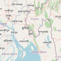
Map view of Satchari National Park

Use this park location map to pinpoint Satchari National Park in Bangladesh, understand its exact geographic position, and read its mapped placement within the surrounding landscape more clearly.

Pigeon | © OpenStreetMap contributors

Location context for Satchari National Park

Habiganj District
Park atlas

Trace the Protected Landscapes and National Parks Across Eastern Bangladesh, covering the Sylhet region's diverse geography

Explore Nearby National Parks and Protected Areas, Expanding Beyond Satchari National Park
After exploring Satchari National Park's tropical forests and primate populations, continue tracing other national parks and protected areas within eastern Bangladesh. Compare their geographic characteristics, conservation focus, and regional distribution to deepen your understanding of Bangladesh's protected landscape mosaic.
National parkMoulvibazar District

Lawachara National Park: Protected National Park Landscape in Moulvibazar District

Mapped Terrain and Endangered Primate Habitat Exploration

Delve into the protected landscape of Lawachara National Park, a key national park located in the distinct undulating terrain of Moulvibazar District, Bangladesh. This area is recognized for its ecological significance, particularly as a sanctuary for endangered primates, including the critically important western hoolock gibbon population. Users can explore the park's mapped boundaries, understand its semi-evergreen forest ecosystem, and appreciate its geological features like sandstone hillocks and sandy-bedded streams, making it a valuable point of discovery for regional geography and conservation landscapes.

Area
12.5 km²
Established
1996
IUCN
II
Relief
Upland
National parkTripura

Clouded Leopard National Park: National Park Protected Area in Tripura's Forested Landscape

Mapped primate habitat and regional geography in Northeast India.

Clouded Leopard National Park serves as a critical protected area within Tripura, India, focusing on the conservation of its forest ecosystems and primate populations, including the Phayre's langur. As part of the larger Sepahijala Wildlife Sanctuary, its mapped boundaries contribute to the regional protected landscape. This national park offers valuable insight into the natural terrain and biodiversity specific to Northeast India, providing a unique geographic focus for atlas exploration.

Area
5.08 km²
Established
2007
IUCN
II
Climate
Tropical
Watercolor painting showing grasses in the foreground, a body of water, and hilly terrain under a pale sky
National parkSylhet District

Khadim Nagar National Park: Bangladesh National Park with Sylhet District Geographic Context

Mapped protected landscape and regional park identity.

Khadim Nagar National Park stands as a significant national park within Sylhet District, Bangladesh, offering a focused point for understanding protected land distribution and geographic features. This entry serves as a resource for exploring the park's specific boundaries and its role within the larger atlas of natural landscapes. Users can gain a clear view of its protected status and its place within the regional geography, facilitating detailed park exploration.

Area
6.79 km²
Established
2006
IUCN
II
Relief
Mixed relief
National parkBangladesh

Bhawal National Park: Mapped Protected Landscape in Bangladesh

Explore its national park designation and regional geography.

Bhawal National Park represents a key protected landscape within Bangladesh. This entry provides detailed information on its identity as a national park, focusing on its mapped geography and protected area significance. Users can explore the park's specific context within the broader South Asian region, understanding its contribution to the nation's conserved natural areas and gaining insight into its landscape character through an atlas-driven perspective.

Area
50.22 km²
Established
1982
IUCN
IV
Relief
Lowland
National parkBhaluka Upazila

Kadigarh National Park National Park: Protected Landscape Atlas and Geographic Overview

Understand Kadigarh National Park's mapped boundaries and regional geography.

Kadigarh National Park is a distinct national park recognized for its protected status within Bhaluka Upazila, Bangladesh. This entry offers an atlas-centric perspective, detailing the park's geographic boundaries and its contribution to the regional landscape. Examine the mapped extent of this protected area and understand its role within the surrounding natural geography, providing a factual basis for exploring its protected landscape identity.

Area
3.441 km²
Established
2010
Climate
Tropical
Access
Easy access
National parkTangail District

Madhupur National Park: Protected Landscape and Geographic Context

Explore its mapped boundaries within Tangail District.

Delve into the protected landscape of Madhupur National Park, a national park located in Tangail District. This resource provides critical geographic context, detailing the park's mapped boundaries and its role as a protected natural area. Understand its placement within the regional geography for a deeper appreciation of Bangladesh's conservation landscapes.

Area
84.36 km²
Established
1982
IUCN
II
Relief
Lowland
National parkChittagong District

Baroiyadhala National Park: A Vital Wildlife Corridor and Protected Forest Landscape in Bangladesh

Discover its terrain, mapped boundaries, and regional significance.

Baroiyadhala National Park, situated in Bangladesh's Chittagong District, stands as a critical national park dedicated to preserving forest ecosystems and functioning as an essential wildlife corridor. The park's undulating terrain and dense vegetation are vital for supporting threatened species and maintaining habitat connectivity. This page offers an atlas-style exploration of Baroiyadhala National Park, detailing its protected area status, geographic context within the Chittagong region, and its significance for conservation in South Asia, providing a rich understanding of its natural landscape.

Area
29.34 km²
Established
2010
IUCN
II
Climate
Tropical
National parkRangamati District

Kaptai National Park: Protected Landscape and Geographic Context in Rangamati District

Explore its mixed evergreen forest and lakeside terrain.

Kaptai National Park is a crucial protected area located in Bangladesh's Rangamati District, renowned for its mixed evergreen forests and unique position adjacent to Kaptai Lake. This detail page provides an atlas-oriented perspective on the park's geographic identity, mapped boundaries, and its role within the diverse Chittagong Hill Tracts region. Understand the terrain, from rolling hills to lakeside environments, and appreciate its conservation significance as a national park.

Area
54.64 km²
Established
1999
IUCN
II
Climate
Subtropical

Common questions about visiting, size, designation, and location context for Satchari National Park

Satchari National Park FAQs for park facts, access, geography, and protected area context
Find quick answers about Satchari National Park, including protected-area facts, park geography, trail and visitor context, and how the park fits into its surrounding country and regional landscape.
MoriAtlas Explorer

Continue Your Protected Areas Search Across the Global Atlas

Deepen your exploration by continuing the structured search for national parks and protected areas worldwide. Utilize the comprehensive filtering capabilities to compare different conservation landscapes and refine your understanding of global park geography. Discover more about the distribution and characteristics of protected natural areas.

Global natural geography