Mori Atlas logo
National parkCutervo National Park

Discover the Mapped Geography and Andean Montane Forests of a Pioneering Conservation Area

Cutervo National Park: Peru's Oldest Protected Landscape in the Cajamarca Region

(Parque Nacional de Cutervo)

Cutervo National Park represents Peru's first national park, established in 1961 within the dramatic mountainous terrain of the northern Peruvian Andes in the Cajamarca Region. This protected landscape spans elevations from 1,550 to 3,500 meters, safeguarding critical Andean montane forests and páramo grasslands. It serves as a vital headwater conservation area, protecting numerous streams originating in the Cordillera de Tarros and preserving a significant segment of the Peruvian Yungas ecoregion, offering a rich context for atlas-driven geographic discovery.

National ParkAndean MountainsMontane ForestsPáramo EcosystemsCloud ForestPeru

Cutervo National Park

National park

Park overview

Structured park overview, official facts, and landscape profile for Cutervo National Park

Cutervo National Park park facts, protected area profile, and essential visitor context
Review the core facts for Cutervo National Park, including designation, size, terrain, visitor scale, habitats, and operating context in one park-focused overview.

About Cutervo National Park

Cutervo National Park represents a cornerstone of Peru's conservation heritage as the nation's first established national park. Located in the remote highlands of Cajamarca, the park occupies a strategic position in the northern Andes, protecting watersheds that feed downstream communities and agricultural lands. The terrain is characterized by steep mountain slopes, deep valleys, and the prominent Cordillera de Tarros, which contains numerous caves and serves as the source of multiple streams that traverse the protected area. The park's dual-sector configuration, with a smaller northern zone and a larger southern zone, reflects the expansion that occurred in 2006 when the original 2,500-hectare park was extended to its current size to better protect the完整性 of the montane forest ecosystem. The surrounding buffer zone, established in 2007, helps mitigate external pressures on the park's boundaries. The park's ecological character is defined by the transition from cloud forest at lower elevations through Polylepis forest zones to páramo grasslands at the highest reaches, creating a complex mosaic of habitats that supports extraordinary biodiversity.

Quick facts and research context for Cutervo National Park

Cutervo National Park covers 8,214 hectares in the Cutervo Province of Cajamarca Region, Peru. Established on September 8, 1961, it is the oldest national park in Peru. The park is managed by SERNANP and is divided into northern and southern sectors, with a surrounding buffer zone of approximately 19,426 hectares. Elevations range from 1,550 to 3,500 meters, with the Cordillera de Tarros forming the highest feature. The park experiences high rainfall exceeding 800mm annually, with temperatures varying from 18-23°C at lower elevations to 7-14°C at the highest zones.

Park context

Deeper park guide and search-rich context for Cutervo National Park

Cutervo National Park history, landscape, wildlife, and travel context
Explore Cutervo National Park through its history, landscape character, ecosystems, wildlife, conservation priorities, cultural context, and seasonal travel timing in a structured park guide built for atlas discovery and search intent.

Why Cutervo National Park stands out

Cutervo National Park is best known as Peru's oldest national park and a critical保护区 for Andean biodiversity. It protects the southernmost extent of páramo ecosystems in Peru and preserves old-growth montane forests dominated by Polylepis woodlands and Andean wax palms. The park is famous for its extensive cave systems, particularly the Gruta de los Guácharos (Oilbird Cave), which houses populations of the nocturnal oilbird. It also provides crucial habitat for endangered mammals including the spectacled bear and mountain tapir, and supports remarkable birdlife such as the golden-headed quetzal and Andean cock-of-the-rock.

Forest-covered mountains under a blue sky with scattered clouds
Wide landscape view of forested mountains in Cutervo National Park

Cutervo National Park history and protected-area timeline

The history of Cutervo National Park reflects Peru's early commitment to nature conservation in South America. Human occupation of the area dates to the Pre-Columbian era, and archaeological remains within the park, particularly at the El Perolito Archaeological Site, attest to the long human presence in these highlands. The modern conservation movement in the region emerged following the 8th Pan-American Conference held in Lima in 1938, which catalyzed the formation of the National Committee of Nature Protection. The Cultural Federation of Cutervo in Lima subsequently submitted an early proposal for a national park near Cutervo to the Ministry of Agriculture, though this initial effort was not successful. The eventual creation of the park came through the efforts of biologist Salomon Vilchez Murga, who represented the Cajamarca region in congress and championed the protected area concept. Law 13694 establishing Cutervo National Park was passed on September 8, 1961, taking effect twelve days later on September 20, 1961. The original park covered 2,500 hectares. After decades of advocacy for expanded protection, the Peruvian environmental authorities submitted a proposal in 2000 to increase the park's area, resulting in Law 28860, which expanded the park to its current 8,214 hectares on August 3, 2006. The establishment of a buffer zone in 2007 further strengthened the protection framework by addressing pressures from surrounding land uses.

Cutervo National Park landscape and geographic character

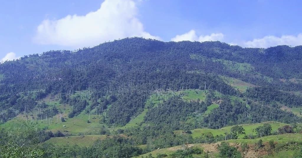
The landscape of Cutervo National Park is defined by its position in the northern Peruvian Andes, where rugged mountain terrain creates a dramatic backdrop of steep ridges, deep ravines, and high-altitude plateaus. The Cordillera de Tarros forms the park's most prominent geographical feature, reaching the highest elevations and serving as the hydrological source for numerous streams that descend through the protected area. Several notable caves punctuate this mountain range, including the Gruta de los Guácharos (Oilbird Cave), Gruta Blanca (White Cave), and Gruta del Murciélago (Bats' Cave), all of which feature impressive stalactite and stalagmite formations. The park's elevation gradient from 1,550 to 3,500 meters creates distinct landscape zones, with cloud-covered forested slopes in the lower reaches giving way to rocky paramo grasslands and small glacial lakes at the highest elevations. The northern sector covers approximately 2,430 hectares while the larger southern sector encompasses nearly 5,785 hectares, together forming a contiguous protected landscape that preserves the ecological integrity of this Andean watershed.

Dense tropical montane forest with palm trees and other green vegetation, showing a lush ecosystem with a rocky outcrop in the midground
Tropical montane forest with palm trees visible in the landscape

Cutervo National Park ecosystems, habitats, and plant life

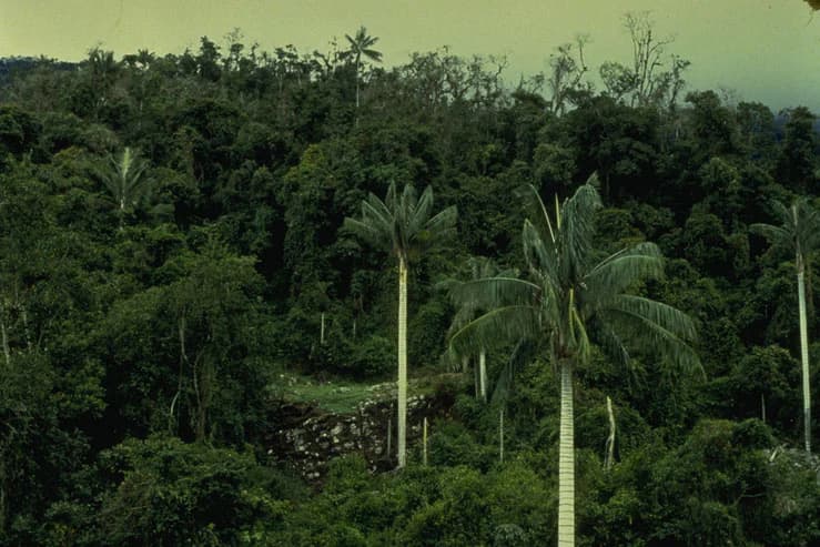
Cutervo National Park protects a significant portion of the Peruvian Yungas ecoregion, one of the most biologically diverse montane forest systems in the world. The park's ecological communities include wet montane forests at lower elevations, transitioning through Polylepis woodlands to high-elevation páramo grasslands above 3,000 meters, interspersed with rivers and small lakes. Over seven hundred species of vascular plants have been recorded within the park, including numerous broadleaved trees such as Chionanthus pubescens, Cornus peruviana, and Vallea stipularis, as well as conifers like Podocarpus oleifolius and the iconic Andean wax palms (Ceroxylon spp.). The park is particularly notable for its orchid diversity, with 88 morphospecies documented. The cloud forest environment, characterized by persistent fog and high humidity, creates ideal conditions for epiphytes, ferns, and moisture-dependent species, making this one of the most botanically rich areas in northern Peru.

Cutervo National Park wildlife and species highlights

The wildlife community of Cutervo National Park includes several mammal species facing extinction risk that find crucial habitat within its protected boundaries. The spectacled bear, South America's only bear species, inhabits the park's montane forests, while the endangered mountain tapir, the largest mammal in the Andes, roams the higher elevation zones. Other notable mammals include the neotropical otter, mountain paca, giant anteater, and the colocolo wild cat (Leopardus colocolo). The park's birdlife is equally remarkable, with the oilbird being a particularly notable resident that roosts in the dark cave systems and feeds on fruit from the palm tree forests. The golden-headed quetzal and Andean cock-of-the-rock represent two of the most visually striking bird species found in the park. Underground streams within the caves harbor a unique species of catfish, Astroblepus rosei, which has adapted to the subterranean aquatic environment. This assemblage of threatened species underscores the park's importance as a conservation refuge in the northern Peruvian Andes.

Cutervo National Park conservation status and protection priorities

Cutervo National Park holds significant conservation value as Peru's oldest national park and a critical protected area within the Andean biodiversity hotspot. Its inclusion in the IUCN Category II classification reflects its primary mandate of protecting natural ecosystems and biodiversity. The park preserves the southernmost extent of páramo ecosystems in Peru, representing a geographically significant boundary for these high-altitude grasslands that are endemic to the northern Andes. The protected area serves essential watershed functions, conserving headwater sources that support downstream communities and agricultural lands in the surrounding regions. The expansion of the park in 2006 and the establishment of the buffer zone in 2007 demonstrate Peru's ongoing commitment to strengthening the protection framework for this important area. However, the park faces ongoing conservation challenges from wood extraction, agricultural expansion, and forest clearing for pastures, as well as social tensions regarding the expanded park boundaries among some local communities.

Cutervo National Park cultural meaning and human context

The Cutervo National Park region has been inhabited since pre-Columbian times, as evidenced by archaeological remains found within the park boundaries, particularly at the El Perolito Archaeological Site. This historical presence indicates that the highland landscape has supported human communities for centuries, with traditional land use practices shaping the relationship between local populations and the mountain environment. The park is located within a network of districts that form part of the Cutervo Province, and the local communities maintain cultural connections to the land that now falls within the protected area. The expansion of the park boundaries in 2006 created some social tensions, as certain local inhabitants have expressed disagreement with the new park limits. Understanding this human dimension is important for effective park management and for developing conservation strategies that respect both ecological integrity and community livelihoods.

Top sights and standout views in Cutervo National Park

Cutervo National Park stands as Peru's pioneering protected area, established in 1961 to preserve the extraordinary biodiversity of the northern Andean highlands. The park's cloud-covered montane forests shelter over 700 plant species, including the iconic Andean wax palms and 88 orchid species, while its caves support colonies of the unusual oilbird. The mountains provide habitat for endangered species including the spectacled bear and mountain tapir, making it one of Peru's most important conservation areas. Visitors can explore three major caves with impressive stalactite formations and underground streams, while the high-elevation páramo zones contain grassland and lakes that complete this diverse mountain landscape. The park's elevation range from 1,550 to 3,500 meters creates a complete vertical gradient of Andean ecosystems within a relatively compact protected area.

Best time to visit Cutervo National Park

The optimal time to visit Cutervo National Park is during the dry season from July to October, when conditions are most favorable for camping and hiking activities. During this period, visitor access is facilitated by reduced precipitation and more stable weather conditions in the highland environment. The park's forests are covered in clouds and fog almost year-round, creating the characteristic cloud forest environment that supports the area's exceptional biodiversity. The wetter months bring higher rainfall, sometimes exceeding 1,500mm annually, which can make trail conditions more challenging but also maintains the lush vegetation that defines the park's character. Temperature variations are significant across the park's elevation range, with warmer conditions in the lower forest zones and cooler temperatures in the páramo areas above 2,500 meters.

Park location guide

Geography guide, regional context, and park location map for Cutervo National Park

Cutervo National Park park geography, regions, and map view in Peru
Understand where Cutervo National Park sits in Peru through a broader geographic reading of the surrounding landscape, nearby location context, and its mapped position within the national park landscape.

How Cutervo National Park fits into Peru

Peru is a megadiverse country in western South America with a population of over 34 million. It spans three distinct geographic regions: the Pacific coastal desert in the west, the Andes mountains running north to south, and the Amazon rainforest in the east. The country has one of the longest histories of civilization in the world, tracing back to the Caral-Supe civilization of the 10th millennium BCE, and was home to the Inca Empire before Spanish colonization in the 16th century.

Wider geography shaping Cutervo National Park in Peru

Peru is located in western South America along the Pacific coast. The country encompasses three major geographic regions: the coastal desert plains along the Pacific, the Andes mountain range extending from north to southeast, and the Amazon basin rainforest in the eastern interior. It shares borders with Ecuador and Colombia to the north, Brazil to the east, Bolivia to the southeast, and Chile to the south.

Map view of Cutervo National Park

Use this park location map to pinpoint Cutervo National Park in Peru, understand its exact geographic position, and read its mapped placement within the surrounding landscape more clearly.

Pigeon | © OpenStreetMap contributors

Location context for Cutervo National Park

Cajamarca RegionCutervo Province

Trace the rugged Andean terrain, montane forests, and diverse páramo habitats that define Peru's oldest protected area through compelling visuals.

Cutervo National Park: Visual Exploration of Andean Landscapes and Protected Habitats
View comprehensive imagery showcasing the unique montane forests, rugged Andean terrain, and distinct páramo grasslands that characterize Cutervo National Park. These visual insights provide a deeper understanding of the park's diverse ecosystems and its vital role as Peru's oldest protected landscape.

Forest-covered mountains under a blue sky with scattered clouds

Lush green hillside with tall palm trees, dense forested hills in the background, and misty mountains under an overcast sky

Dense tropical montane forest with palm trees and other green vegetation, showing a lush ecosystem with a rocky outcrop in the midground

Park atlas

Explore the broader regional geography of protected areas, comparing diverse Andean landscapes and montane ecosystems near Cutervo National Park.

Discover More Andean Protected Areas and National Parks Near Cutervo National Park
After exploring Cutervo National Park, continue your geographic discovery by browsing other national parks and protected areas situated within the surrounding Peruvian Andes. Compare diverse montane forests, páramo grasslands, and cave systems across the region, tracing the broader protected-landscape context.
National parkZamora Chinchipe

Yacurí National Park: Protected Andean Lakes and Volcanic Landscape in Zamora Chinchipe

Discover highland geography and the ancient Inca Trail.

Yacurí National Park is a key protected landscape in Ecuador's southern Andes, celebrated for its remarkable collection of over 46 high-altitude lakes set within dramatic volcanic terrain. Situated in Zamora Chinchipe province, the park preserves a vital stretch of the Inca Trail, complete with archaeological sites. This national park offers a rich exploration of Andean geography, páramo ecosystems, and significant cultural heritage, making it a cornerstone of the region's protected areas.

Area
431 km²
Established
2009
IUCN
II
Relief
Mountain
National parkEcuador

Podocarpus National Park: Ecuador's Diverse National Park and Protected Landscape

Discover elfin forests, paramo, and over 100 lagoons.

Podocarpus National Park, situated in southeastern Ecuador, stands as a prime example of a protected natural area at a unique biogeographic crossroads. This national park spans dramatic elevational zones, from montane rain forests to high-elevation paramo ecosystems dotted with more than 100 lagoons, offering rich mapped landscape exploration. Its significance lies in the convergence of four distinct ecological systems, contributing to exceptional biodiversity and a rich tapestry of natural terrain.

Area
1,462.8 km²
Established
1982
IUCN
II
Relief
Mountain
National parkSan Martín Region

Rio Abiseo National Park: Peru's Protected Landscape Identity and Geographic Context

Discover the mapped boundaries and regional atlas information.

Investigate Rio Abiseo National Park, a designated national park situated within the San Martín Region of Peru. This detailed entry focuses on its protected landscape characteristics and its specific geographic placement. Understand the park's mapped boundaries and its role in the broader atlas of protected areas, offering a structured approach to geographic discovery.

Area
2,745.2 km²
Established
1983
IUCN
II
Relief
Mountain
National parkPeru

Cerros de Amotape National Park: Peru's Protected Pacific Tropical Forest Atlas

Explore mapped boundaries and diverse terrain of this unique landscape.

Cerros de Amotape National Park stands as a significant protected area within Peru, meticulously preserving remnants of the Tumbes-Piura dry forests and Pacific tropical forests. Situated within the Cordillera de los Amotapes, the park features a dynamic landscape from riverine habitats to elevated mountain terrain. This park detail page offers an atlas-style view, focusing on its geographic context, mapped protected boundaries, and its importance as a conservation corridor for unique biodiversity.

Area
1,515.61 km²
Established
1975
IUCN
II
Relief
Mountain
National parkPeru

Cordillera Azul National Park: A National Park for Geographic Discovery in Peru

Explore Peru's protected landscape and regional map context.

Cordillera Azul National Park serves as a dedicated entry point for understanding Peru's protected natural areas through a geographic lens. This park's identity is tied to its specific mapped boundaries and its contribution to the nation's diverse terrain. Focusing on Cordillera Azul National Park allows for detailed atlas exploration of its unique landscape context within western South America, providing factual data for geographic understanding.

Area
13,531.9 km²
Established
2001
IUCN
II
Relief
Mountain
National parkAncash

Huascarán National Park: Protected Landscape and Regional Geography in Ancash, Peru

Explore the mapped boundaries of this significant national park.

Huascarán National Park is a protected national park located in the Ancash region of Peru, offering valuable insights for geographic and atlas exploration. This destination provides detailed information on the park's mapped boundaries, its designation as a national park, and its integration into the regional geography. Understanding Huascarán National Park helps contextualize protected land distribution and landscape features within Peru for those interested in structured geographic discovery and atlas-style mapping.

Area
3,400 km²
Established
1975
IUCN
II
Relief
Mountain
National parkHuánuco Region

Tingo María National Park: National Park Protected Landscape in Huánuco Region, Peru

Atlas exploration of park boundaries and regional geography.

Investigate Tingo María National Park, a key protected area situated in the Huánuco Region of Peru. This national park designation signifies its importance for understanding the country's natural landscapes and mapped geography. Explore its protected territory and discover its place within the regional atlas.

Area
47.778 km²
Established
1965
IUCN
II
Relief
Mountain
Watercolor illustration showing a mountain landscape with a snow-capped peak, a lake, and green hills.
National parkEcuador

Sangay National Park: Ecuador's National Park for Mapped Landscape and Geographic Discovery

Explore Ecuador's protected area boundaries and regional terrain.

Sangay National Park serves as a crucial protected landscape within Ecuador, offering rich opportunities for atlas and geography exploration. This page details the park's specific mapped boundaries and its natural terrain, providing essential context for understanding its place within South America's broader geographic tapestry. Investigate Sangay National Park's identity as a protected national park and its value for focused landscape and regional discovery.

Area
5,177.65 km²
Established
1979
IUCN
II

Common questions about visiting, size, designation, and location context for Cutervo National Park

Cutervo National Park FAQs for park facts, access, geography, and protected area context
Find quick answers about Cutervo National Park, including protected-area facts, park geography, trail and visitor context, and how the park fits into its surrounding country and regional landscape.
MoriAtlas Explorer

Continue Your Protected Areas Search Across the Global Atlas

Deepen your exploration by continuing the structured search for national parks and protected areas worldwide. Utilize the comprehensive filtering capabilities to compare different conservation landscapes and refine your understanding of global park geography. Discover more about the distribution and characteristics of protected natural areas.

Global natural geography