Mori Atlas logo
National parkRío Pilcomayo National Park

Map the unique floodplain geography and vital conservation areas of this Formosa Province national park.

Río Pilcomayo National Park: Humid Chaco Wetland Atlas & Protected Landscape Discovery

(Parque Nacional Río Pilcomayo)

Discover Río Pilcomayo National Park, a significant protected area in Argentina's Formosa Province renowned for its extensive Humid Chaco wetland ecosystems. This national park, established to conserve representative floodplain terrain, features vast grasslands, marshes, lakes, and forests shaped by the Pilcomayo River's seasonal dynamics. As a Ramsar Wetland of International Importance, it offers critical habitat for diverse wildlife, including the endangered jaguar, and showcases distinctive Caranday palm savannas. Explore its mapped boundaries and unique landscape context for a comprehensive understanding of this vital protected natural area.

National ParkWetlandsFloodplainChacoRamsar SiteWildlife Conservation

Río Pilcomayo National Park

National park

Park overview

Structured park overview, official facts, and landscape profile for Río Pilcomayo National Park

Río Pilcomayo National Park park facts, protected area profile, and essential visitor context
Review the core facts for Río Pilcomayo National Park, including designation, size, terrain, visitor scale, habitats, and operating context in one park-focused overview.

About Río Pilcomayo National Park

Río Pilcomayo National Park protects a representative sample of the Eastern or Humid Chaco ecological region, one of South America's most distinctive biomes. The park's flat, low-lying terrain was formed through geological processes involving the filling of a Paleozoic crystalline rock depression with both organic and inorganic sediments, creating the sedimentary basin that underlies the protected area. The park's eastern portions feature silts and clays creating less permeable soils, while western areas contain coarser, more porous soils. This subtle variation in terrain elevation, though minimal, plays a crucial role during the wet season when the area becomes covered with interconnected pools and channels forming in the lowest-lying zones. The park's location on the border with Paraguay places it at the heart of one of South America's most important wetland systems. The Pilcomayo River, after which the park is named, serves as the lifeblood of the ecosystem, with its seasonal flooding creating the extensive marshes and lakes that define the park's character. The administration operates from Laguna Blanca, with a visitor recreation area offering camping facilities, trails, and observation platforms overlooking key wetland areas.

Quick facts and research context for Río Pilcomayo National Park

Río Pilcomayo National Park spans roughly 51,889 hectares in northeastern Argentina's Formosa Province, near the Paraguay border. The protected area was established in 1951 under Law 14073 and falls under IUCN Category II. The landscape consists of a gently sloping plain with minimal elevation variation, where subtle differences in terrain elevation become significant during the wet season when large areas become inundated. The subtropical climate features average temperatures of 23°C and annual precipitation around 1,200 mm, with summer extremes exceeding 40°C and occasional winter frosts. The park was reduced from its original 285,000 hectares in 1968, with the removed land transferred to provincial jurisdiction.

Park context

Deeper park guide and search-rich context for Río Pilcomayo National Park

Río Pilcomayo National Park history, landscape, wildlife, and travel context
Explore Río Pilcomayo National Park through its history, landscape character, ecosystems, wildlife, conservation priorities, cultural context, and seasonal travel timing in a structured park guide built for atlas discovery and search intent.

Why Río Pilcomayo National Park stands out

Río Pilcomayo is best known for its extensive wetland systems and floodplain landscapes that represent the Humid Chaco ecoregion. The park protects critical habitat for the endangered jaguar population, which represents one of the last strongholds of this large cat in Argentina's Chaco region. The park's Laguna Blanca, a 700-hectare lake at the southern end, provides crucial habitat for waterfowl and serves as a resting point for migratory birds traveling from the Northern Hemisphere. The Caranday wax palm dominates the savanna landscapes, creating one of the park's most distinctive visual features. The wetlands support remarkable biodiversity including both caiman species found in Argentina, the broad-snouted and yacare caiman, as well as significant populations of waterfowl, storks, herons, and roseate spoonbills.

Wetland landscape with shallow water, patches of grass, and scattered palm-like trees and dense shrubs
Marshes within Río Pilcomayo National Park

Río Pilcomayo National Park history and protected-area timeline

Río Pilcomayo National Park was created by Law 14073, passed on September 29, 1951 and promulgated on October 17, 1951 by Decree 20756/1951. The original park boundary encompassed approximately 285,000 hectares, making it one of Argentina's larger protected areas at the time of its establishment. However, at the request of the Formosa Provincial Legislature, the park's boundaries were significantly reduced in 1968 with the passage of Law 17915 on September 27, 1968, reducing the protected area to its current 51,889 hectares. The excluded land was transferred to provincial jurisdiction. In 1990, a portion of the park was designated as a Strict Nature Reserve under Decree 2149/90, with the reserve boundaries further modified in 1994 by Decree 453/1994, which created the Wilderness Nature Reserve. The park's management plan, the Five-Year Management Plan 2007-2011, was approved in 2006. In 2011, the Administration of Parks National classified the park as a Complexity Level II protected area, placing it under the administration of an appointed superintendent overseeing four departments and two divisions.

Río Pilcomayo National Park landscape and geographic character

The park occupies a vast, gently sloping plain characteristic of the Humid Chaco region, with minimal elevation variation across its extent. The landscape was formed when a depression in ancient crystalline rocks was filled with sediments, creating the flat terrain that dominates the protected area. The uppermost sediment layers are of fluvial and aeolian origin, deposited by ancient river systems and wind. The eastern portions of the park feature finer soils dominated by silts and clays that create less permeable conditions, while the western areas contain coarser, more porous soils. Subtle differences in elevation, though barely perceptible to the casual observer, become critically important during periods of heavy rainfall when water collects in the lowest areas, creating extensive temporary wetlands. The park contains several significant water bodies, with Laguna Blanca being the largest at approximately 700 hectares. The Pilcomayo River and its former channels traverse the landscape, creating a network of riparian zones and floodplain areas. The terrain is characterized by extensive grasslands, palm-dominated savannas, and scattered forest islands that rise above the surrounding wetlands.

Wooden boardwalk path through dense green aquatic plants with tall grasses and a clear blue sky in the background
Wooden boardwalk winding through dense green vegetation under a clear blue sky in Río Pilcomayo National Park

Río Pilcomayo National Park ecosystems, habitats, and plant life

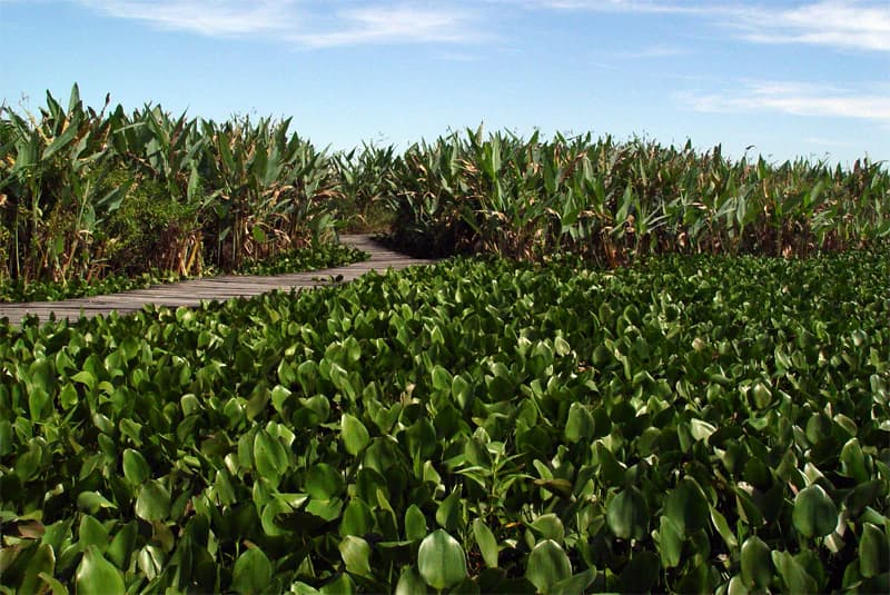
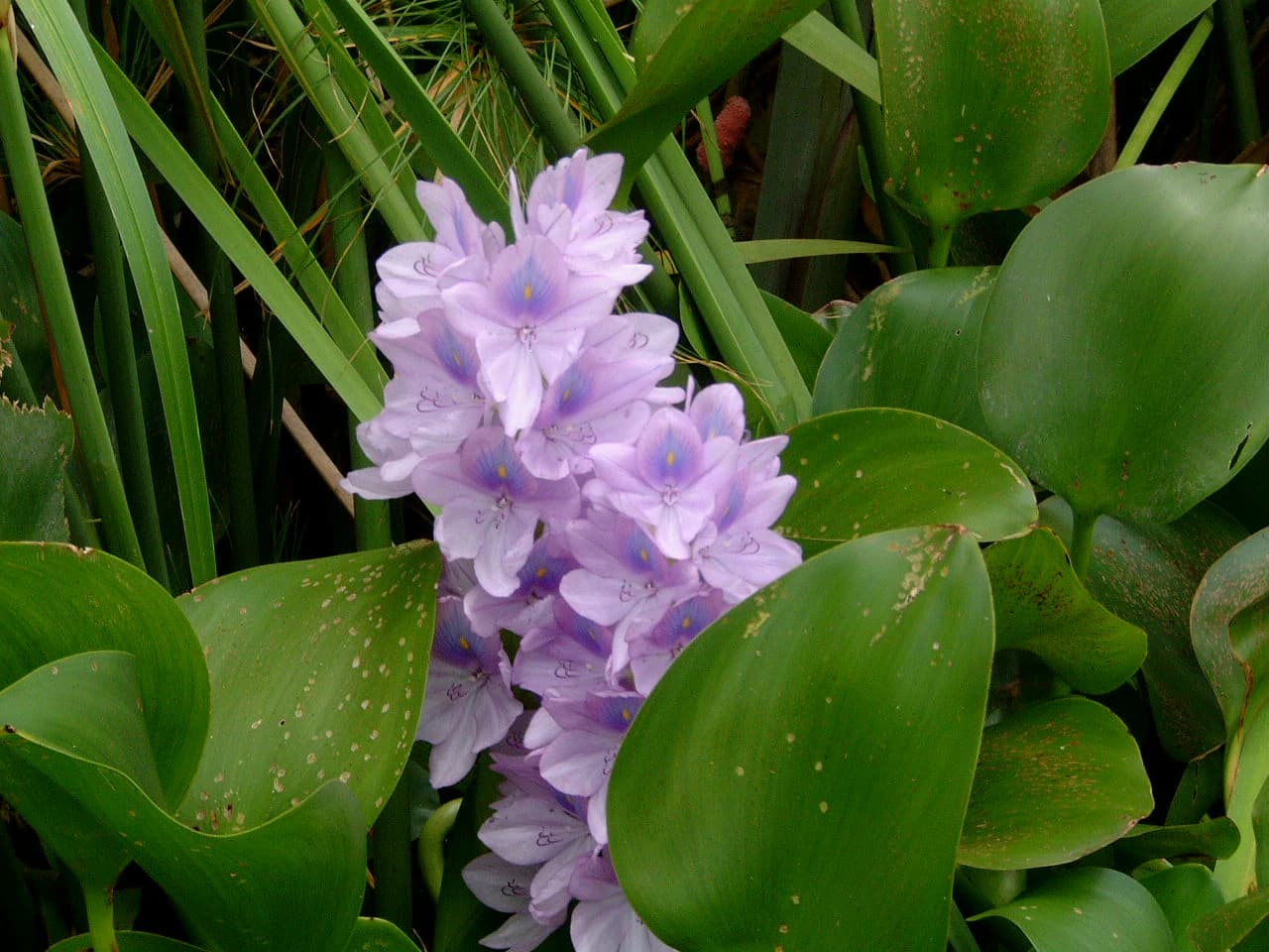
The park protects four distinct vegetation zones that reflect the variation in soil types, hydrology, and elevation across the protected area. The savanna zone is dominated by the Caranday wax palm, an unofficial emblem of the region that towers above dense herbaceous vegetation, particularly species from the genus Scirpus. Other tree species in this zone include Acacia caven and Prosopis nigra. Wetland areas are characterized by floating aquatic vegetation including water hyacinths, Limnocharitaceae, Nymphoides, and Ludwigia species. The riparian zone along the Pilcomayo River and its former channels features figs and sweetwood trees, often covered with lianas, vines, and epiphytes. The fourth zone consists of patchy vegetation on higher lands forming distinctive "mountain islands" where quebracho trees, including Schinopsis balansae and Aspidosperma quebracho-blanco, can be found. The park's position within the Humid Chaco means it experiences seasonal flooding that creates a dynamic landscape where wetland and terrestrial habitats alternate according to rainfall patterns.

Purple water hyacinth flowers surrounded by large green leaves with water droplets
Purple water hyacinth flowers with broad green leaves in Río Pilcomayo National Park

Río Pilcomayo National Park wildlife and species highlights

The park supports remarkable wildlife diversity across its terrestrial and aquatic habitats. The higher land areas are home to mammals including gray brocket, capybara, peccary, howler monkey, and puma, while birds such as chachalacas and rails inhabit these zones. The lowland areas and grasslands shelter the distinctive maned wolf along with greater rhea and seriemas, all species adapted to moving through tall grasses and flooded areas thanks to their long limbs. The park holds particular significance for jaguars, with the populations in Río Pilcomayo and El Impenetrable National Park representing the last strongholds of this endangered feline in Argentina's Chaco region. Aquatic environments support storks, herons, roseate spoonbills, and various duck species, while both caiman species found in Argentina occur here: the broad-snouted caiman and the yacare caiman. Fish populations include species from the Hoplosternum genus that can breathe atmospheric air, allowing them to survive in shallow water bodies during drought periods. Snake species include the yellow anaconda and Hydrodynastes gigas, a large water snake.

Dirt road leading to a gate with a sign that reads 'PARQUE NACIONAL RIO PILLCOMAYO FORMOSA REPUBLICA ARGENTINA', with palm trees and grassland in the background
Entrance sign at Río Pilcomayo National Park in Formosa, Argentina

Río Pilcomayo National Park conservation status and protection priorities

Río Pilcomayo National Park holds significant conservation importance as a protected representative sample of the Humid Chaco ecoregion, one of South America's most threatened biomes. The park's designation as a Ramsar Wetland of International Importance in 1992 underscores its global significance for waterbird habitat preservation and wetland biodiversity conservation. The protected area serves as a critical refuge for jaguar populations, which face serious threats throughout Argentina, making the park essential for the survival of this iconic species in the country. The wetland systems provide crucial habitat for migratory birds traveling between the Northern Hemisphere and southern South America, while the diverse vegetation communities represent various stages of the Humid Chaco ecosystem. The park's strict nature reserve sections provide protection for the most sensitive areas, ensuring that core habitats remain undisturbed. The management plan framework guides conservation activities while balancing visitor access to appropriate areas of the park.

Río Pilcomayo National Park cultural meaning and human context

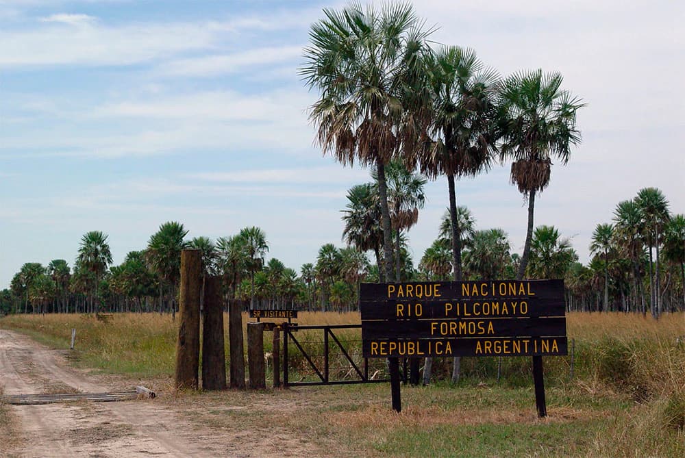
The park is situated in the department of Pilcomayo in Formosa Province, with access via National Routes 11 and 86 passing near the protected area. The town of Laguna Blanca serves as the administrative center and provides access to the park's visitor facilities. Local communities in the surrounding region maintain connections to the land, with traditional activities including fishing and limited agriculture in the broader floodplain system. The park's name derives from the Pilcomayo River, which itself carries cultural significance for indigenous communities in the border region between Argentina and Paraguay. The wetlands and floodplain landscapes have been important to regional communities for generations, with the seasonal flooding patterns traditionally influencing local resource use and settlement patterns.

Calm river reflecting a wooden observation tower and palm tree with lush green vegetation along the banks under a partly cloudy sky
Observation tower reflected in calm waters of the Río Pilcomayo National Park

Top sights and standout views in Río Pilcomayo National Park

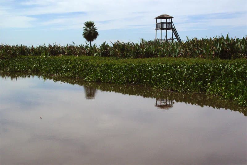
Río Pilcomayo National Park offers visitors the opportunity to experience one of Argentina's most significant wetland wilderness areas. The Laguna Blanca observation platform provides sweeping views over the park's largest lake, where yacare caimans can often be seen basking on the water's edge. The interpretive trails traverse diverse habitats, from palm savannas to riparian forests, allowing visitors to observe the park's varied wildlife. The network of boardwalks passes through extensive reed beds where capybaras and waterfowl are commonly encountered. The park's jaguar population, while elusive, represents a major draw for wildlife enthusiasts seeking to experience one of South America's most iconic predators in its natural habitat. The Caranday palm forests create a distinctive landscape unlike any other protected area in Argentina, particularly during the dry season when the palms stand out against the surrounding grasslands.

Wooden observation platform extending over calm water with three people silhouetted against sunset sky
Silhouette of visitors at observation platform during sunset on Laguna Blanca

Best time to visit Río Pilcomayo National Park

The optimal time to visit Río Pilcomayo depends on what visitors hope to experience. The wet season, roughly from October through March, brings the Pilcomayo River's flooding and creates extensive wetland areas with maximum waterbird activity. Migratory birds from the Northern Hemisphere arrive during this period, making it an excellent time for birdwatching. However, some areas may be less accessible due to flooding. The dry season, from April through September, offers easier access to trails and viewing areas as water levels recede, exposing mudflats and creating smaller, more concentrated water bodies that attract wildlife. Summer months (December to February) can bring extreme heat exceeding 40°C, while winter nights may be cool. The park experiences frequent tornadoes, particularly during the warmer months, so visitors should be aware of weather conditions.

Park location guide

Geography guide, regional context, and park location map for Río Pilcomayo National Park

Río Pilcomayo National Park park geography, regions, and map view in Argentina
Understand where Río Pilcomayo National Park sits in Argentina through a broader geographic reading of the surrounding landscape, nearby location context, and its mapped position within the national park landscape.

How Río Pilcomayo National Park fits into Argentina

Argentina is a federal republic located in the southern cone of South America, bordering Chile, Bolivia, Paraguay, Brazil, Uruguay, and the Atlantic Ocean. With an area of 2,780,085 km², it is the second-largest country in South America and the eighth-largest globally. The capital and largest city is Buenos Aires, and the official language is Spanish. The country claims sovereignty over the Falkland Islands, South Georgia and the South Sandwich Islands, and a portion of Antarctica.

Wider geography shaping Río Pilcomayo National Park in Argentina

Argentina occupies the southern portion of South America, sharing the Southern Cone region with Chile to the west. The country borders Bolivia and Paraguay to the north, Brazil to the northeast, Uruguay and the South Atlantic Ocean to the east, and the Drake Passage to the south. The Andes mountain range runs along the western border, while the Pampas plains dominate the central region. Argentina also claims territories in Antarctica.

Map view of Río Pilcomayo National Park

Use this park location map to pinpoint Río Pilcomayo National Park in Argentina, understand its exact geographic position, and read its mapped placement within the surrounding landscape more clearly.

Pigeon | © OpenStreetMap contributors

Location context for Río Pilcomayo National Park

Formosa Province

Explore the unique floodplain terrain, Caranday palm savannas, and critical wetland habitats of Argentina's Humid Chaco ecoregion.

Río Pilcomayo National Park Photos: Visualizing Wetlands, Chaco Landscapes, and Wildlife Scenery
Browse a curated collection of Río Pilcomayo National Park images, showcasing its expansive wetland systems, iconic Caranday palm savannas, and diverse protected environments. These visuals offer essential context for understanding the park's distinctive Humid Chaco character, its rich floodplain landscapes, and the vital conservation of its unique ecosystems.

Wetland landscape with shallow water, patches of grass, and scattered palm-like trees and dense shrubs

Grassy field with palm trees and scattered vegetation under a clear blue sky

Wooden boardwalk path through dense green aquatic plants with tall grasses and a clear blue sky in the background

Purple water hyacinth flowers surrounded by large green leaves with water droplets

Dirt road leading to a gate with a sign that reads 'PARQUE NACIONAL RIO PILLCOMAYO FORMOSA REPUBLICA ARGENTINA', with palm trees and grassland in the background

A wide river with muddy brown water flows through dense green trees and grasses under a partly cloudy sky

Calm river reflecting a wooden observation tower and palm tree with lush green vegetation along the banks under a partly cloudy sky

Wooden observation platform extending over calm water with three people silhouetted against sunset sky

Caiman (Yacaré) lying on a wooden pier in a muddy river

Park atlas

Compare the protected landscapes and wetland systems across Argentina's Chaco ecoregion and surrounding territories.

Explore Related National Parks and Protected Areas Near Río Pilcomayo National Park
Continue your geographic discovery from Río Pilcomayo National Park by exploring a curated selection of national parks and protected areas within the broader Humid Chaco ecoregion. Deepen your understanding of regional park geography, compare unique floodplain environments, and trace interconnected wetland conservation landscapes.
National parkParaguay

Ypoá National Park: Paraguay's Protected Wetland Landscape and Lake Ecosystem

Explore mapped boundaries and significant bird habitats in the Ñeembucú region.

Ypoá National Park is a critical protected area in Paraguay, renowned for its extensive wetland ecosystems dominated by Lake Ypoá. This national park encompasses a rich mosaic of marshlands, riparian forests, and aquatic vegetation, making it a significant habitat for numerous bird species, including several rare and endemic types. Its designation as a Ramsar Wetland underscores its ecological importance, offering a unique lens for understanding landscape context and protected-area geography within South America.

Area
1,000 km²
Established
1992
IUCN
II
Relief
Lowland
National parkChaco Province

Chaco National Park: Protected Landscape and Regional Geography Atlas

Explore mapped boundaries within the Eastern Chaco's unique ecosystem.

Chaco National Park is an important protected area in Chaco Province, Argentina, dedicated to preserving the unique Eastern Chaco ecosystem. Covering 150 square kilometers, its landscape comprises warm lowland terrain with scrubland, savanna, swamp areas, and scattered lakes. This national park is recognized for its efforts to conserve the distinctive quebracho forests and supports a rich array of wildlife, making it a key site for understanding regional protected-area geography and landscape context.

Area
150 km²
Established
1954
IUCN
II
Relief
Lowland
National parkItapúa Department

San Rafael National Park: National Park Protected Landscape & Geographic Overview

Discover the mapped boundaries and regional setting in Itapúa.

San Rafael National Park is a significant protected area designated as a national park in Paraguay's Itapúa Department. This page serves as an atlas-centric entry point, offering a detailed view of its geographic scope, mapped park boundaries, and its role as a conservation landscape. Users can explore the park's terrain and its place within the regional geography for a structured understanding of its protected status.

Area
693.04 km²
Established
1992
IUCN
II
Relief
Upland
National parkArgentina

El Impenetrable National Park: A Protected National Park within Argentina's Geography

Explore its mapped boundaries and regional landscape context.

Delve into El Impenetrable National Park, a designated national park situated in Argentina. This entry provides critical geographic context, detailing its mapped protected area boundaries and its role within the national landscape. Understand its unique regional setting and explore its significance as a protected natural space for atlas-based discovery.

Area
1,289 km²
Established
2014
Relief
Lowland
Climate
Subtropical
National parkCorrientes Province

Mburucuyá National Park: National Park in Corrientes Province, Argentina

Iconic yatay palm savannas and diverse wetland ecosystems.

As a key national park within Argentina's Corrientes Province, Mburucuyá National Park offers a unique atlas-scale view of ecological convergence. It preserves expansive yatay palm savannas, critical wetland habitats within the Iberá Wetlands, and lush subtropical forests. The park's boundaries define an area where the Humid Chaco, Espinal, and Selva Paranaense biomes meet, creating a landscape of exceptional biodiversity and geographic significance for regional conservation and mapped exploration.

Area
176.82 km²
Established
2001
IUCN
II
Relief
Lowland
National parkCorrientes Province

Iberá National Park: National Park Atlas Exploration in Corrientes Province

Mapped protected area context and regional geography.

Delve into the atlas view of Iberá National Park, a designated national park situated in Corrientes Province, Argentina. This detailed entry clarifies the park's protected landscape identity and its contribution to the regional geography of northeastern Argentina. Understand its mapped boundaries and explore its significance as a conservation area within the Mesopotamia region.

Area
1,835 km²
Established
2018
IUCN
II
Relief
Lowland
National parkParaguay

Ñacunday National Park National Park: Paraguay's Protected Landscape and Mapped Boundaries

Explore its unique geography and protected terrain.

Gain a precise understanding of Ñacunday National Park, a designated national park in Paraguay. This entry focuses on its role as a protected landscape, detailing its geographic attributes and mapped boundaries. It serves as a vital resource for users seeking specific information on the park's natural terrain and its contribution to Paraguay's conservation geography, facilitating structured discovery within the atlas.

Area
20 km²
Established
1993
Relief
Mixed relief
Climate
Subtropical
National parkMisiones Province

Iguazú National Park: Argentina's Misiones Province Protected Landscape Atlas

Explore mapped boundaries and regional geography.

Iguazú National Park serves as a key protected natural area situated within Misiones Province. This MoriAtlas entry details its mapped geographic boundaries, contributing essential context for understanding its landscape identity. Users can explore how this national park fits into the regional geography, providing a factual basis for detailed atlas-based study of protected lands and their unique terrain.

Area
677 km²
Established
1934
IUCN
II
Relief
Lowland

Common questions about visiting, size, designation, and location context for Río Pilcomayo National Park

Río Pilcomayo National Park FAQs for park facts, access, geography, and protected area context
Find quick answers about Río Pilcomayo National Park, including protected-area facts, park geography, trail and visitor context, and how the park fits into its surrounding country and regional landscape.
MoriAtlas Explorer

Continue Your Protected Areas Search Across the Global Atlas

Deepen your exploration by continuing the structured search for national parks and protected areas worldwide. Utilize the comprehensive filtering capabilities to compare different conservation landscapes and refine your understanding of global park geography. Discover more about the distribution and characteristics of protected natural areas.

Global natural geography