Mori Atlas logo
National parkBadiar National Park

Trace the mapped boundaries and regional geography of this significant protected area in West Africa.

Badiar National Park: Guinea's Protected National Park Landscape and Geographic Context

(Parc National du Badiar)

Badiar National Park stands as a notable protected area within Guinea, offering a window into the nation's diverse geography and conservation landscapes. This entry provides essential context for understanding the park's mapped boundaries and its role within the broader West African atlas. Explore the park's protected landscape identity and its place in Guinea's natural terrain, facilitating a structured discovery of this significant national park.

National ParkSavanna EcosystemTransboundary ConservationWest AfricaGallery ForestBird Watching

Badiar National Park

National park

Park overview

Structured park overview, official facts, and landscape profile for Badiar National Park

Badiar National Park park facts, protected area profile, and essential visitor context
Review the core facts for Badiar National Park, including designation, size, terrain, visitor scale, habitats, and operating context in one park-focused overview.

About Badiar National Park

Badiar National Park represents one of Guinea's most significant protected areas and serves as a critical ecological link in the West African transboundary conservation landscape. The park's establishment in 1985 reflected growing regional awareness about the importance of protecting shared ecosystems across national borders, particularly given the ecological continuity between Badiar and the much larger Niokolo-Koba National Park in Senegal. The park consists of two geographically separate sectors that together encompass a diverse range of habitats, from savanna plains to gallery forests and scrub woodland. The surrounding buffer zone of nearly 6,000 square kilometers demonstrates the recognition that effective conservation requires landscape-level management beyond strict protected area boundaries. The Badiar Biosphere Reserve, established in 2002, formalizes this broader conservation approach by incorporating the park together with the Southern Badiar forest and the Forest of Ndama as core conservation areas within a functioning ecosystem. This designation reflects the park's importance not only as a refuge for biodiversity but also as a model for regional environmental cooperation in West Africa.

Quick facts and research context for Badiar National Park

Badiar National Park covers 1,228 square kilometers in northeastern Guinea near the town of Koundara. The park is divided into two sectors, Mafou (554 km²) and Kouya (674 km²), surrounded by a substantial buffer zone. The principal waterways include the Koulountou River, a major tributary of the Gambia River, and the Mitji River. The region experiences annual rainfall of 1,000 to 1,500 millimeters, concentrated during the June-to-October rainy season. The park was established in 1985 by ordinance and serves as a core area of the Badiar Biosphere Reserve, which encompasses a broader region of 2,843 square kilometers including adjacent forest areas.

Park context

Deeper park guide and search-rich context for Badiar National Park

Badiar National Park history, landscape, wildlife, and travel context
Explore Badiar National Park through its history, landscape character, ecosystems, wildlife, conservation priorities, cultural context, and seasonal travel timing in a structured park guide built for atlas discovery and search intent.

Why Badiar National Park stands out

Badiar National Park is best known as a transboundary protected area that forms an ecological continuum with Senegal's Niokolo-Koba National Park, creating a larger conservation corridor across the Senegal-Guinea border. The park is recognized as an Important Bird Area by BirdLife International due to its significant populations of bird species including violet turacos, red-throated bee-eaters, blue-bellied rollers, and Senegal parrots. It shelters several endangered mammal species including western chimpanzees, African elephants, giant eland, and leopards, as well as the western red colobus. The park's gallery forests along the Koulountou River provide critical habitat within an otherwise savanna-dominated landscape.

Badiar National Park history and protected-area timeline

Badiar National Park was established on May 30, 1985 through ordinance N°124/PRG/85, marking Guinea's commitment to protecting its northeastern savanna ecosystems. The timing of the park's creation was influenced significantly by regional security concerns, particularly Senegal's apprehension about poaching pressures emanating from across the border that threatened the integrity of Niokolo-Koba National Park. This cross-border conservation motivation established the foundation for what would become a transboundary ecological partnership. In 2002, the park gained additional recognition through its designation as the core area of the Badiar Biosphere Reserve under UNESCO's Man and the Biosphere Programme. This biosphere reserve status expanded the conservation framework to include adjacent forest areas and recognized the broader ecological and socioeconomic context of the region. The establishment of the biosphere reserve reflected an evolving understanding that effective conservation requires considering human communities and their relationship to the landscape, integrating biodiversity protection with sustainable development objectives.

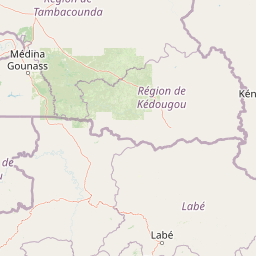
Badiar National Park landscape and geographic character

The physical landscape of Badiar National Park presents a characteristic West African savanna environment with notable variation between its eastern and western sectors. The eastern portion of the park features scrub woodland dominated by scattered shrubs and small trees adapted to the seasonal rainfall patterns, while the western sector transitions into more densely wooded savanna and open forest environments. Gallery forests follow the principal river courses, particularly along the Koulountou which ranks among the two main tributaries of the Gambia River system, providing verdant linear corridors of denser vegetation that contrast sharply with the surrounding savanna. The Mitji River represents another significant watercourse within the park's boundaries. The terrain generally consists of gently undulating plains with limited elevation variation, typical of the Guinea's northeastern transitional zone between the coastal forest regions and the Sahelian savanna to the north. Annual rainfall between 1,000 and 1,500 millimeters falls predominantly during the June-to-October rainy season, creating distinct wet and dry season cycles that shape vegetation patterns and drive ecological processes throughout the park.

Badiar National Park ecosystems, habitats, and plant life

The ecological character of Badiar National Park is defined by the interaction between savanna and forest habitats within a semi-deciduous tropical environment. The park's vegetation includes savanna grasslands, open woodlands dominated by various Acacia and Combretum species, and the distinctive gallery forests that follow river corridors. These gallery forests represent particularly important ecological niches, maintaining more humid conditions and supporting species characteristic of West African forest environments in an otherwise savanna-dominated landscape. The park is recognized as an important ecosystem for vertebrate biodiversity, hosting numerous mammal species alongside diverse bird communities. The Badiar Biosphere Reserve designation in 2002 formalized the park's role within a broader ecological framework that recognizes the connectivity between the protected core area and surrounding landscapes. This biosphere reserve approach acknowledges that the park's ecological integrity depends on maintaining functional connections with adjacent forest areas, particularly the Southern Badiar forest and the Forest of Ndama that together form the complete reserve system.

Badiar National Park wildlife and species highlights

Badiar National Park supports a notable assembly of West African wildlife, with particular significance for several endangered and regionally restricted species. The mammal population includes substantial populations of African elephants, roan antelope, kob, and giant eland, the latter representing one of the largest antelope species in Africa. Predators present include leopards and spotted hyenas, while the Guinea baboon represents an important primate species in the region. The park provides crucial habitat for endangered primates including the western red colobus and western chimpanzee, both of which face significant conservation pressures across their ranges. The avifauna is exceptionally diverse, with the park's designation as an Important Bird Area reflecting the presence of significant populations of species including violet turacos, red-throated bee-eaters, blue-bellied rollers, Senegal parrots, piapiacs, black-capped babblers, purple starlings, and white-crowned robin-chats. Reptile species of conservation note include the African rock python and ball python, while the white stork represents a significant bird species that migrates through the region.

Badiar National Park conservation status and protection priorities

Badiar National Park holds significant conservation importance at both national and regional levels within West Africa. Its designation as an IUCN Category II national park reflects its primary objective of protecting natural ecosystems while allowing for limited sustainable use. The park's role as a core area within the Badiar Biosphere Reserve demonstrates a sophisticated approach to conservation that integrates habitat protection with broader landscape management considerations. The transboundary relationship with Senegal's Niokolo-Koba National Park creates a larger protected area complex that enhances ecological connectivity and supports species that require large home ranges, particularly large mammals like elephants and predators. The Important Bird Area designation by BirdLife International further underscores the park's international significance for avian conservation. However, the park faces ongoing challenges related to poaching pressures that were a motivating factor in its establishment, and maintaining effective conservation will require continued cooperation between Guinea and Senegal. The presence of endangered plant species including Ceiba pentandra, Cassia sieberiana, and Combretum micranthum indicates the need for attention to both faunal and floral conservation targets.

Badiar National Park cultural meaning and human context

The cultural context of Badiar National Park relates to the broader region of northeastern Guinea, which sits at the intersection of several West African cultural zones. The park's proximity to the border with Senegal and the ecological continuity with Niokolo-Koba National Park reflects a landscape where human communities and wildlife have interacted across political boundaries for generations. The establishment of the biosphere reserve framework in 2002 incorporated consideration of local communities and their traditional land use practices within the broader conservation planning approach. While the Wikipedia source does not provide detailed information about specific indigenous communities or cultural heritage sites within the park, the broader region is historically inhabited by various groups whose traditional livelihoods include agriculture, pastoralism, and utilization of forest resources. The biosphere reserve designation implies recognition that sustainable conservation requires engaging with these community relationships to the landscape.

Top sights and standout views in Badiar National Park

The most distinctive highlights of Badiar National Park include its role as Guinea's primary transboundary protected area, creating an ecological continuum with Senegal's Niokolo-Koba National Park across the international border. The gallery forests along the Koulountou River represent particularly notable landscape features, providing lush green corridors within the savanna environment and supporting forest-dependent species. The park's status as an Important Bird Area highlights its exceptional avian diversity, with species like the violet turaco and red-throated bee-eater providing vibrant natural spectacle. The presence of endangered large mammals including African elephants, western chimpanzees, and giant eland underscores the park's conservation significance within West Africa's rapidly changing landscapes. The Badiar Biosphere Reserve framework demonstrates a mature approach to conservation that extends protection beyond the core park boundaries to encompass a broader functioning ecosystem.

Best time to visit Badiar National Park

The optimal time to visit Badiar National Park aligns with the dry season, typically from November through April, when rainfall is minimal and wildlife becomes more concentrated around remaining water sources. The rainy season from June to October brings heavy precipitation that can make certain areas difficult to access and reduces visibility for wildlife observation, though the landscape becomes verdant and rivers flow strongly. The transition periods at the start and end of the rainy season offer intermediate conditions. Visitors interested in birdwatching will find the dry season particularly productive as resident bird species become more active and visible in the thinner vegetation. Temperatures remain warm throughout the year in this region of Guinea, with the dry season generally offering more comfortable conditions for outdoor activities. Planning should account for the park's location in northeastern Guinea and the need to coordinate with local authorities regarding access arrangements.

Park location guide

Geography guide, regional context, and park location map for Badiar National Park

Badiar National Park park geography, regions, and map view in Guinea
Understand where Badiar National Park sits in Guinea through a broader geographic reading of the surrounding landscape, nearby location context, and its mapped position within the national park landscape.

Map view of Badiar National Park

Use this park location map to pinpoint Badiar National Park in Guinea, understand its exact geographic position, and read its mapped placement within the surrounding landscape more clearly.

Pigeon | © OpenStreetMap contributors
Park atlas

Map the diverse savanna ecosystems, gallery forests, and transboundary protected landscapes across West Africa's Guinea-Senegal border region.

Explore National Parks and Protected Areas Surrounding Badiar National Park, Guinea
Browse national parks and protected areas sharing similar savanna, woodland, and gallery forest ecosystems near Badiar National Park, extending across Guinea and into neighboring Senegal. Compare their geographic features and conservation frameworks to understand the broader West African protected landscape context, including important transboundary agreements.
National parkSenegal

Niokolo-Koba National Park: Exploring Senegal's Protected Landscape Identity

Mapped boundaries and regional geography context.

Niokolo-Koba National Park offers a distinct focus on Senegal's protected landscapes, providing valuable insights for atlas and map-based exploration. This national park serves as a key geographic anchor, highlighting the natural terrain and the extent of its protected boundaries within the country. Users can delve into the specific characteristics of this area to understand its role within Senegal's diverse natural heritage and regional geography.

Area
9,130 km²
Established
1954
IUCN
II
Relief
Upland
National parkCentral River Division

River Gambia National Park: National Park Geography and Protected Landscape Atlas

Discover mapped boundaries within Central River Division.

River Gambia National Park represents a key protected area within the Central River Division, offering specific geographic insights for atlas exploration. This page details the park's mapped boundaries and its role as a national park, providing a factual basis for understanding its landscape context and regional importance. Explore the geographic features that define this protected natural area.

Area
5.85 km²
Established
1978
IUCN
II
Relief
Lowland
Wildlife reserveGambia

Bao Bolong Wetland Reserve: West African Wildlife Reserve with Extensive Mangrove Ecosystems

Explore mapped terrain and crucial protected wetland boundaries.

Bao Bolong Wetland Reserve in Gambia is a significant protected area renowned for its ecological importance as a Ramsar wetland and Important Bird Area. This wildlife reserve features the tallest mangrove trees in the Senegambia region, transitioning through salt marshes to savanna, all centered around the Bao Bolong tributary's estuary. Its complex hydrological network and diverse habitats support 268 bird species and are crucial for the endangered West African manatee, offering a rich landscape for geographic and protected-area discovery.

Area
220 km²
Established
1996
IUCN
VI
Relief
Lowland
National parkGambia

Kiang West National Park: National Park Detail and Protected Landscape Geography

Explore mapped boundaries and regional context in The Gambia.

Kiang West National Park serves as a crucial point for understanding protected natural areas within The Gambia, West Africa. This national park's identity is rooted in its geographic setting along the Gambia River, offering a distinct landscape context and mapped territory. Users can explore its boundaries and place within the nation's conservation network, contributing to a structured understanding of regional geography and protected lands.

Area
115 km²
Established
1987
IUCN
II
Relief
Lowland
National parkMali

Bafing National Park: Mali National Park Atlas and Protected Woodland Landscape

Explore the unique chimpanzee habitat and bird conservation within this West African savanna.

Bafing National Park is a cornerstone of conservation in Mali, recognized for its exclusive role in protecting chimpanzee populations within the Manding Plateau region. This extensive national park features a predominant woodland ecosystem interspersed with savanna areas, providing critical habitat for numerous bird species as designated by BirdLife International. Understanding Bafing National Park's mapped geography and protected landscape offers insight into vital primate and avian conservation efforts in West Africa.

Area
5,000 km²
Established
2000
IUCN
II
Relief
Upland
National parkGuinea-Bissau

Orango National Park: Protected Landscape and Geographic Atlas Explorer in Guinea-Bissau

Discover mapped park boundaries and regional natural terrain.

Delve into the protected-area identity of Orango National Park, a significant national park located in Guinea-Bissau. This page provides essential geographic context, mapping details, and landscape character for atlas-driven exploration. Understand how Orango National Park fits within the broader regional geography of West Africa, offering a focused view of protected lands for dedicated discovery.

Area
1,582 km²
Established
2000
IUCN
II
Relief
Lowland
Marine protected areaBolama Region

João Vieira and Poilão Marine National Park: Mapped Marine Protected Area in Bolama Region

Explore protected marine boundaries and regional geography.

João Vieira and Poilão Marine National Park is identified as a crucial marine protected area within the Bolama Region. This atlas-focused entry details its geographic scope and protected status, offering a clear view of its mapped landscape. It serves as a primary reference for understanding the park's specific marine environment and its place within the broader regional geography.

Area
495 km²
Established
2000
IUCN
II
Relief
Lowland
National parkMali

Kouroufing National Park: Mali's National Park with Defined Protected Landscape Boundaries

Explore the mapped geography and protected land context of Kouroufing National Park.

Kouroufing National Park is a significant protected area recognized as a national park within Mali. This entry focuses on its distinct geographic identity and mapped boundaries, essential for understanding its role in the regional atlas. Examine the park's protected landscape context and how it contributes to the natural geography of West Africa. This resource is tailored for users seeking detailed information on specific protected areas rather than broad travel advice.

Area
557 km²
Established
2002
Scope
Terrestrial
Water
No major water

Common questions about visiting, size, designation, and location context for Badiar National Park

Badiar National Park FAQs for park facts, access, geography, and protected area context
Find quick answers about Badiar National Park, including protected-area facts, park geography, trail and visitor context, and how the park fits into its surrounding country and regional landscape.
MoriAtlas Explorer

Continue Your Protected Areas Search Across the Global Atlas

Deepen your exploration by continuing the structured search for national parks and protected areas worldwide. Utilize the comprehensive filtering capabilities to compare different conservation landscapes and refine your understanding of global park geography. Discover more about the distribution and characteristics of protected natural areas.

Global natural geography