

Mori Atlas logo
National parkKiang West National Park

Discover the geographic scope and mapped boundaries of this significant protected area in The Gambia.

Kiang West National Park: Gambia's Premier National Park & Protected Landscape Identity

Kiang West National Park stands as a notable protected area within the nation of The Gambia, a country situated along the vital Gambia River in West Africa. This designation highlights its importance for understanding the regional geography and the distribution of conservation landscapes across the smallest continental African nation. Exploration here provides essential context for the park's unique place within Gambia's natural terrain and its broader mapped environment.

National ParkSavannaBirdwatchingWildlife ReserveRiver EcosystemMangrove

Kiang West National Park

National park

Park overview

Structured park overview, official facts, and landscape profile for Kiang West National Park

Kiang West National Park park facts, protected area profile, and essential visitor context
Review the core facts for Kiang West National Park, including designation, size, terrain, visitor scale, habitats, and operating context in one park-focused overview.

About Kiang West National Park

Kiang West National Park represents the flagship protected area of The Gambia, preserving a substantial tract of Guinea savanna and dry deciduous woodland ecosystem along the Gambia River corridor. The park's location on the south bank of West Africa's principal river creates a distinctive blend of terrestrial and aquatic habitats, supporting wildlife populations that have largely disappeared from other parts of the country. The landscape features a network of three bolons, or seasonal creeks, that create natural divisions within the park and provide critical wet-season habitat for aquatic species. The vegetation is characterized by baobab trees, red acacia, and diverse deciduous species typical of the Guinea savanna zone. Visitors access the park through the headquarters at Dumbuto Village, with Tendaba Camp serving as the traditional base for wildlife excursions since the 1970s. The park remains relatively undeveloped in terms of tourism infrastructure, preserving its wild character while offering visitors an authentic encounter with Gambian natural environments.

Quick facts and research context for Kiang West National Park

Kiang West National Park spans 11,526 hectares in the Lower River Division of The Gambia, positioned on the south bank of the Gambia River approximately 145 kilometers from Banjul. The park was established in 1987 and is managed by the Gambia Department of Parks and Wildlife Management under IUCN Category II protection. The terrain consists largely of Guinea savanna and dry deciduous woodland on a low-altitude plateau, with tidal flats and mangrove creeks along the river boundary. The park contains no permanent settlements, though villages lie adjacent to its borders. It hosts more than 300 bird species, representing over half of all bird species recorded in the Gambia.

Park context

Deeper park guide and search-rich context for Kiang West National Park

Kiang West National Park history, landscape, wildlife, and travel context
Explore Kiang West National Park through its history, landscape character, ecosystems, wildlife, conservation priorities, cultural context, and seasonal travel timing in a structured park guide built for atlas discovery and search intent.

Why Kiang West National Park stands out

Kiang West National Park is especially renowned for its exceptional bird diversity, having been designated an Important Bird Area by BirdLife International. The park hosts more than 300 bird species, including 21 birds of prey species, making it a premier destination for birdwatching in West Africa. The park's bateleur eagle serves as its official symbol. The protected area is also notable for supporting populations of larger mammals including leopards, caracals, servals, and the West African manatee, which can be observed in the Jarin bolon alongside humpback dolphins. The combination of savanna woodlands, riverine habitats, and mangrove ecosystems creates a remarkable diversity of wildlife within a relatively compact area.

Kiang West National Park history and protected-area timeline

Kiang West National Park was established in 1987 as part of The Gambia's developing national park system. The protected area was created to preserve the country's significant wildlife heritage and savanna ecosystems, which were facing increasing pressure from agricultural expansion and human settlement. Management authority rests with the Gambia Department of Parks and Wildlife Management, the governmental body responsible for protected area administration across the country. The park's establishment reflected growing recognition of the Gambia River corridor's importance as a wildlife migration route and biodiversity hotspot. Prior to national park designation, the area functioned as a wildlife reserve, and the transition to full protected status enhanced legal protections and management resources. The park remains one of the Gambia's primary conservation success stories, maintaining viable populations of species that have declined elsewhere in the region.

Kiang West National Park landscape and geographic character

The physical landscape of Kiang West National Park is defined by its position on the south bank of the Gambia River and the surrounding Guinea savanna plateau. The terrain is predominantly flat to gently rolling, with elevation remaining low throughout the park. The three bolons that traverse the park—Jarin, Jali, and Nganingkoi—create natural corridors and seasonal water features that interrupt the woodland canopy. Along the northern boundary, the Gambia River provides a permanent water source and creates riparian zones with tidal flats and mangrove creek systems. The vegetation transitions between dry deciduous woodland on the higher ground and more open savanna in areas influenced by the water table. Baobab trees serve as iconic landscape features, their distinctive swollen trunks visible across the savanna. The combination of river frontage, seasonal creeks, tidal mangroves, and savanna woodlands creates a visually diverse landscape within the protected area.

Kiang West National Park ecosystems, habitats, and plant life

The ecological character of Kiang West National Park reflects the Guinea savanna biome at its western limit in West Africa. The park preserves a mosaic of habitats including dry deciduous woodland, open savanna, tidal flats, and mangrove creeks. Tree species include the iconic baobab alongside red acacia, Pterocarpus erinaceus, Ceiba pentandra, Terminalia macroptera, and various Ficus species. The grassy understory features Andropogon species and other savanna grasses. The riparian zone along the Gambia River supports distinct plant communities adapted to seasonal flooding and tidal influence. This habitat diversity supports remarkable biodiversity, with the park containing the majority of Gambia's remaining wildlife in a relatively intact ecosystem. The combination of savanna and riverine environments creates ecological conditions found nowhere else in the Gambia.

Kiang West National Park wildlife and species highlights

Kiang West National Park supports the most diverse wildlife community of any protected area in The Gambia. The mammal population includes the African clawless otter, bushbuck, caracal, common duiker, leopard, marsh mongoose, serval, sitatunga, spotted hyena, warthog, and West African manatee. The West African manatee and humpback dolphins are occasionally observed in the Jarin bolon, representing the park's aquatic mammal interest. The reptile population includes the African python, Bell's hinged tortoise, West African crocodile, Nile monitor, puff adder, royal python, and spitting cobra. The birdlife is exceptional, with more than 300 species recorded—representing over half of all bird species documented in the Gambia. Twenty-one birds of prey species are present, including eagles, falcons, harriers, hawks, and vultures, with particularly high numbers during the dry season. The bateleur, a short-tailed eagle, serves as the park's symbol and can be observed hunting sandgrouse and pigeons. Notable species include ground-hornbills, the threatened brown-necked parrot that breeds in the mangroves, and several species with restricted distributions within the Gambia such as white-fronted black chat, Dorst's cisticola, Burchell's courser, brown-rumped bunting, and chestnut-crowned sparrow-weaver.

Kiang West National Park conservation status and protection priorities

Kiang West National Park represents one of The Gambia's most significant conservation achievements, preserving the country's largest remaining tract of intact savanna ecosystem. The designation as an Important Bird Area by BirdLife International underscores the site's global significance for avian biodiversity. However, the park faces ongoing conservation challenges including annual forest fires that damage vegetation, with a significant fire in 2001 burning through the length of the park over two days. Local communities retain traditional rights to gather limited firewood and forest products, and to cultivate some rice within park boundaries, creating management tensions between conservation objectives and local livelihood needs. The park serves as a critical refuge for species that have disappeared from other areas of the Gambia, making it essential for national biodiversity conservation. Maintaining the ecological integrity of the Gambia River corridor depends significantly on the protected status of Kiang West.

Kiang West National Park cultural meaning and human context

While Kiang West National Park itself is unpopulated, the surrounding landscape contains villages whose residents maintain connections to the protected area. Local communities retain limited rights to collect forest products and practice seasonal rice cultivation within park boundaries, reflecting the integration of traditional land use with modern conservation. The Tendaba Camp has operated since the 1970s as the primary base for visitors exploring the park, creating a long-standing tradition of tourism-related employment in the area. The park is situated within the Kiang West District, named for the traditional Kiang region that has historical significance in Gambian regional administration.

Top sights and standout views in Kiang West National Park

Kiang West National Park offers exceptional birdwatching opportunities with over 300 species including the bateleur eagle as the park's symbol and 21 birds of prey species. The river boundary provides opportunities to observe West African manatees and humpback dolphins in the Jarin bolon. The landscape features iconic baobab trees and a network of three bolons creating diverse habitats. Tubabkollon Point in the northeast offers wildlife viewing from a sandy beach beside the Gambia River. The park receives relatively few tourists, providing a wilderness experience unlike more visited West African protected areas.

Best time to visit Kiang West National Park

The optimal period to visit Kiang West National Park is during the dry season from November to January, when wildlife viewing conditions are most favorable. The dry season brings reduced vegetation density, making animals easier to observe, and large numbers of birds of prey concentrate in the park. The bateleur eagle is most commonly observed from July to September. Visitor numbers remain low throughout the year, preserving the park's tranquil atmosphere. The wet season from June to October brings challenging travel conditions on the park's underdeveloped road system.

Park location guide

Geography guide, regional context, and park location map for Kiang West National Park

Kiang West National Park park geography, regions, and map view in Gambia
Understand where Kiang West National Park sits in Gambia through a broader geographic reading of the surrounding landscape, nearby location context, and its mapped position within the national park landscape.

How Kiang West National Park fits into Gambia

The Gambia is a small West African nation located along the Gambia River, which flows from east to west and empties into the Atlantic Ocean. It is the smallest country in continental Africa by area and is almost entirely surrounded by Senegal. The country gained independence from Britain in 1965 and operates as a unitary presidential republic with Banjul as its capital.

Wider geography shaping Kiang West National Park in Gambia

The Gambia occupies a narrow strip of land along the Gambia River in West Africa. The country spans approximately 11,300 km² and is almost completely surrounded by Senegal, with only a short Atlantic coastline in the west. The terrain is generally flat with floodplains along the river.

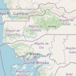
Map view of Kiang West National Park

Use this park location map to pinpoint Kiang West National Park in Gambia, understand its exact geographic position, and read its mapped placement within the surrounding landscape more clearly.

Pigeon | © OpenStreetMap contributors

Location context for Kiang West National Park

Kiang West DistrictLower River Division
Park atlas

Compare surrounding protected areas and trace the regional park geography beyond Kiang West National Park.

Explore National Parks and Protected Areas Near Kiang West National Park, The Gambia
Explore other protected areas and national parks surrounding Kiang West National Park, tracing diverse savanna, riverine, and mangrove ecosystems across the region. This geographic overview provides valuable context for comparing adjacent conservation landscapes, enhancing your West African park discovery.
Wildlife reserveGambia

Bao Bolong Wetland Reserve: West African Wildlife Reserve with Extensive Mangrove Ecosystems

Explore mapped terrain and crucial protected wetland boundaries.

Bao Bolong Wetland Reserve in Gambia is a significant protected area renowned for its ecological importance as a Ramsar wetland and Important Bird Area. This wildlife reserve features the tallest mangrove trees in the Senegambia region, transitioning through salt marshes to savanna, all centered around the Bao Bolong tributary's estuary. Its complex hydrological network and diverse habitats support 268 bird species and are crucial for the endangered West African manatee, offering a rich landscape for geographic and protected-area discovery.

Area
220 km²
Established
1996
IUCN
VI
Relief
Lowland
National parkGambia

Niumi National Park: Gambia's Extensive Mangrove Forest and Coastal Wetland Protected Area

Explore the mapped boundaries and unique delta geography of this important national park.

Niumi National Park, situated in The Gambia, is a crucial protected coastal area celebrated for its vast Rhizophora mangrove forests and diverse wetland ecosystems. As a designated national park and Ramsar site, it serves as a critical habitat for numerous migratory bird species, particularly terns, and supports vulnerable marine life. Its landscape is characterized by tidal channels, brackish lagoons, and intertidal mudflats, creating a dynamic and ecologically significant protected zone that is a focal point for understanding West African coastal geography and conservation.

Area
49.4 km²
Established
1987
IUCN
II
Relief
Lowland
National parkGambia

Tanbi Wetland Complex National Park: A Mapped Protected Area in The Gambia

Explore its protected boundaries and regional landscape.

Delve into the geographic identity of Tanbi Wetland Complex National Park, a designated protected area within The Gambia. This page provides essential atlas-level information, focusing on its mapped natural landscape and its role as a significant national park. Understand the park's protected status and its geographical context along the Gambia River, offering a clear entry point for conservation landscape discovery.

Area
45 km²
Established
2001
IUCN
II
Relief
Lowland
Nature reserveGambia

Abuko Nature Reserve: A Protected Nature Reserve in Gambia's Landscape

Explore its mapped boundaries and geographic context.

Abuko Nature Reserve is a protected natural area situated in Gambia, offering a distinct focus for understanding protected landscapes. This entry provides essential details for atlas-based discovery, highlighting the reserve's mapped boundaries and its role within the regional geography. Examine Abuko Nature Reserve to gain clarity on its protected status and its contribution to the mapped natural terrain of West Africa.

Area
1.07 km²
Established
1968
IUCN
IV
Relief
Lowland
National parkSenegal

Saloum Delta National Park: Detailed Map Exploration of Senegal's Protected Landscape

Explore the mapped boundaries and regional terrain of this national park.

Saloum Delta National Park, a designated national park in Senegal, serves as a key entity for understanding protected landscapes in West Africa. This entry focuses on its geographic specificities, providing mapped context and details about its natural terrain. Users can explore the park's boundaries and regional landscape character, contributing to a richer atlas-based discovery of Senegal's conservation areas and natural geography.

Area
760 km²
Established
1976
Relief
Lowland
Climate
Tropical
National parkGambia

Tanji Bird Reserve National Park: Coastal Wetlands and Avian Diversity in Gambia

Explore unique geography and protected landscape boundaries.

Tanji Bird Reserve National Park showcases a distinctive coastal landscape where the Atlantic Ocean meets lagoons, dry woodland, and dune scrub. This 612-hectare protected area in The Gambia is celebrated for its incredible birdlife, with nearly 300 species recorded, including significant Palearctic migrants and the nation's sole breeding seabird colonies on the Bijol Islands. The reserve offers a rich context for understanding West African protected areas, mapped terrain, and coastal ecosystem geography.

Area
6.12 km²
Established
1993
IUCN
II
Relief
Lowland
Watercolor illustration of a river flowing through a landscape with trees, grassy areas, and distant hills under a soft sky
National parkCentral River Division

River Gambia National Park: National Park Geography and Protected Landscape Atlas

Discover mapped boundaries within Central River Division.

River Gambia National Park represents a key protected area within the Central River Division, offering specific geographic insights for atlas exploration. This page details the park's mapped boundaries and its role as a national park, providing a factual basis for understanding its landscape context and regional importance. Explore the geographic features that define this protected natural area.

Area
5.85 km²
Established
1978
IUCN
II
Relief
Lowland
National parkZiguinchor Region

Basse Casamance National Park: National Park with Mapped Boundaries in Ziguinchor Region

Detailed protected landscape and regional geography context.

Basse Casamance National Park serves as a critical protected area, offering users a clear view of its national park designation and its specific geographic location within Senegal. This entity is vital for understanding conservation landscapes and mapped terrain in the Ziguinchor Region. The platform provides structured data on its protected boundaries, allowing for focused atlas exploration and a deeper appreciation of its regional geographic significance without leaving the core park identity.

Area
50 km²
Established
1970
IUCN
II
Climate
Tropical

Common questions about visiting, size, designation, and location context for Kiang West National Park

Kiang West National Park FAQs for park facts, access, geography, and protected area context
Find quick answers about Kiang West National Park, including protected-area facts, park geography, trail and visitor context, and how the park fits into its surrounding country and regional landscape.
MoriAtlas Explorer

Continue Your Protected Areas Search Across the Global Atlas

Deepen your exploration by continuing the structured search for national parks and protected areas worldwide. Utilize the comprehensive filtering capabilities to compare different conservation landscapes and refine your understanding of global park geography. Discover more about the distribution and characteristics of protected natural areas.

Global natural geography