Mori Atlas logo
National parkAl Hoceima National Park

Discover mapped boundaries, dramatic limestone cliffs, and rich Mediterranean biodiversity.

Al Hoceima National Park: Morocco's Protected Coastal and Marine Landscape

Al Hoceima National Park in northern Morocco offers a unique protected landscape where dramatic Mediterranean coastline meets the foothills of the Rif mountains. This national park encompasses a significant stretch of unspoiled rocky shoreline and vital marine ecosystems, best known for its towering limestone cliffs and diverse underwater environments. Explore the mapped geography of this coastal wilderness and understand its role as a critical refuge for regional biodiversity.

Mediterranean coastlineLimestone cliffsMarine protected areaRif mountainsCoastal wildernessKelp forests

Al Hoceima National Park

National park

Park overview

Structured park overview, official facts, and landscape profile for Al Hoceima National Park

Al Hoceima National Park park facts, protected area profile, and essential visitor context
Review the core facts for Al Hoceima National Park, including designation, size, terrain, visitor scale, habitats, and operating context in one park-focused overview.

About Al Hoceima National Park

Al Hoceima National Park occupies a distinctive position along Morocco's Mediterranean coast, protecting a landscape of exceptional natural value that has remained largely undeveloped despite centuries of human presence in the region. The park's dramatic topography features towering limestone cliffs that drop sharply into the Mediterranean Sea, creating a rugged and visually striking coastline. Behind these coastal cliffs, the terrain rises into the foothills of the Rif mountains, a range that forms part of the larger Atlas mountain system and supports distinct Mediterranean-type vegetation communities. The park's dual nature as both a terrestrial and marine protected area makes it particularly valuable, as it conserves an entire coastal ecosystem from mountain watershed to deepwater marine environments. The marine portion, influenced by the unique convergence of Mediterranean and Atlantic ocean conditions, supports extensive kelp forests and seaweed communities that provide habitat for numerous marine species. This combination of unspoiled coastal scenery, significant biodiversity, and ecological complexity makes Al Hoceima one of Morocco's most important protected coastal areas.

Quick facts and research context for Al Hoceima National Park

The park covers roughly 480 square kilometers, with about 196 square kilometers of marine area and 284 square kilometers of terrestrial terrain spanning the Rif mountains. It extends along 50 kilometers of Mediterranean coastline characterized by high limestone cliffs and wild rocky shores. The terrestrial portion includes portions of five communes: Bni Boufrah, Senada, Rouadi, Izemmouren, and Ait Kamara. The marine zone sits at the confluence of Mediterranean and Atlantic influences, supporting diverse seaweed forests and coastal ecosystems.

Park context

Deeper park guide and search-rich context for Al Hoceima National Park

Al Hoceima National Park history, landscape, wildlife, and travel context
Explore Al Hoceima National Park through its history, landscape character, ecosystems, wildlife, conservation priorities, cultural context, and seasonal travel timing in a structured park guide built for atlas discovery and search intent.

Why Al Hoceima National Park stands out

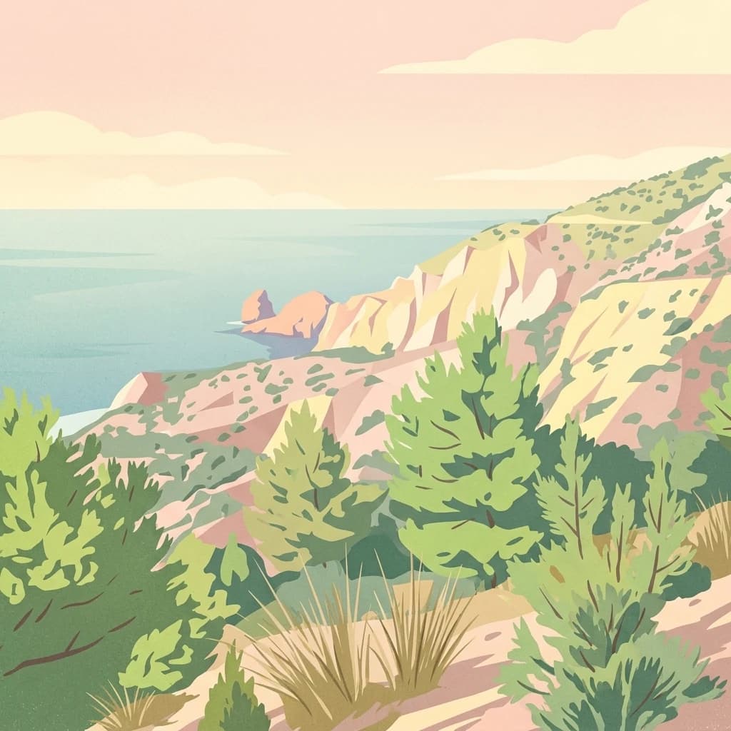
Al Hoceima is best known for its dramatic limestone cliff formations along the Mediterranean coast, its relatively untouched rocky shoreline, and its rich marine biodiversity. The park harbors one of the largest osprey colonies in the region and serves as a foraging ground for three dolphin species, Mediterranean monk seals, and multiple sea turtle species. Its underwater kelp forests and extensive seaweed communities represent a significant marine ecological asset.

Alhucemas (9).JPG
Peñón de Alhucemas, with Aleppo pine and Tetraclinis articulata.

Al Hoceima National Park history and protected-area timeline

Al Hoceima National Park was formally established in 2004 as part of Morocco's expanding network of protected areas designed to conserve the nation's most significant natural landscapes and biodiversity. The park's creation reflected growing recognition of the ecological importance of Morocco's Mediterranean coastline, which had historically remained less developed than the Atlantic shoreline but faced increasing development pressure. The establishment also responded to the need to protect critical habitat for endangered species including the Mediterranean monk seal and various sea turtle species that use the coastal waters. Management of the park was assigned to the Haut-Commissariat des eaux et forêts et de la lutte contre la désertification, Morocco's primary agency for forest management and desertification control. The park was designated under IUCN Category II, reflecting its status as a national park intended to protect natural ecosystems while allowing for sustainable use in designated areas.

Al Hoceima National Park landscape and geographic character

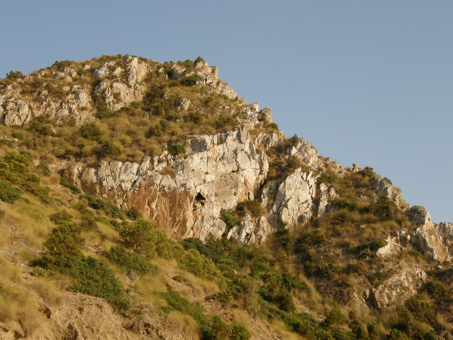
The physical landscape of Al Hoceima National Park is defined by the dramatic contrast between its coastal cliffs and the mountainous interior of the Rif range. The coastline extends for approximately 50 kilometers along the Mediterranean Sea, characterized by high limestone cliffs that rise sharply from the water's edge, creating spectacular sea cliffs and rocky promontories. These cliffs have experienced minimal human exploitation over the years, maintaining their wild and natural character. The terrestrial portion of the park occupies portions of the Ibaqouyen Rif mountain range, where the terrain rises from the coastal lowlands into more rugged mountainous terrain. The combination of coastal cliffs, rocky shores, and mountain foothills creates a diverse landscape that supports multiple habitat types within a relatively compact area. The marine environment features clear waters influenced by both Mediterranean and Atlantic conditions, with underwater terrain that supports extensive kelp and seaweed communities.

Al Hoceima National Park ecosystems, habitats, and plant life

The ecological character of Al Hoceima National Park reflects its position at the intersection of Mediterranean and Atlantic biogeographic influences. Terrestrially, the park supports approximately 110 species of vascular plants adapted to the Mediterranean climate, including characteristic species such as barbary thuya, Aleppo pine, lentisk, wild olive, carob tree, kermes oak, green oak, Mediterranean dwarf palm, and jujube. These species form distinctive vegetation communities that transition from coastal scrub and grassland between rocky outcrops to more developed forest cover in the mountain foothills. The marine environment is particularly significant, with 264 species of seaweed recorded in the park's waters. The underwater community is dominated by forests of brown algae including various Cystoseira species, Saccorhiza polyschides, and Laminaria species, creating complex three-dimensional habitat structures that support diverse marine life. This combination of Mediterranean and Atlantic marine influences makes the park's waters unusually productive and biodiverse.

Al Hoceima National Park wildlife and species highlights

Al Hoceima National Park supports significant wildlife populations across both terrestrial and marine environments. The avifauna includes a notable colony of ospreys, a species of conservation concern in the Mediterranean region that relies on coastal cliffs for nesting habitat. The marine waters are home to three regularly occurring dolphin species: common dolphins, common bottlenose dolphins, and striped dolphins, all of which feed and transit through the park's protected waters. The park also provides critical habitat for the endangered Mediterranean monk seal, which occasionally uses sea caves along the coast for shelter. The waters serve as feeding grounds for several species of sea turtles, including loggerhead, leatherback, and green sea turtles. The fish community includes over 100 species, and the park also supports the rare giant ribbed Mediterranean limpet, a species of conservation concern in the Mediterranean basin.

Al Hoceima National Park conservation status and protection priorities

Al Hoceima National Park represents an important conservation asset for Morocco and the broader Mediterranean region. The park protects one of the most unspoiled sections of Morocco's Mediterranean coastline, preserving both terrestrial and marine ecosystems that face increasing pressure from coastal development and maritime activities. The protection of the marine environment is particularly significant given the unusual confluence of Mediterranean and Atlantic conditions that support exceptional biodiversity, including extensive kelp forests and important habitat for endangered species. The park's designation as an IUCN Category II protected area reflects its primary purpose of ecosystem conservation while allowing for compatible human uses. Conservation priorities include protecting critical habitat for Mediterranean monk seals and sea turtles, maintaining the health of kelp forest communities, and preserving the wild character of the coastal cliffs that support breeding osprey populations.

Al Hoceima National Park cultural meaning and human context

The park's territory encompasses portions of five communes—Bni Boufrah, Senada, Rouadi, Izemmouren, and Ait Kamara—where local communities maintain connections to the landscape through traditional land use practices. The area has historical significance as part of the broader Rif region, which has been inhabited for centuries and carries cultural heritage tied to the mountainous and coastal terrain. The park's Arabic name, المنتزه الوطني للحسيمة, and its name in Tarifit, Afrag Anamur n Lhusima, reflect the multilingual character of the region. While the park is managed primarily for natural conservation, the surrounding communities maintain ties to the coastal and mountain landscapes that the park protects.

Top sights and standout views in Al Hoceima National Park

The park's most distinctive features include its spectacular 50-kilometer Mediterranean coastline with towering limestone cliffs, its well-preserved wild character despite centuries of human presence in the region, and its rich marine biodiversity spanning both Mediterranean and Atlantic-influenced species. The underwater kelp forests represent a particularly notable ecological feature, supporting complex marine communities. The presence of ospreys, dolphins, sea turtles, and occasional Mediterranean monk seals provides exceptional wildlife observation opportunities in both terrestrial and marine environments. The transition from mountain Rif terrain to coastal cliffs to marine environments creates a remarkably diverse landscape within a single protected area.

Best time to visit Al Hoceima National Park

The park can be visited throughout the year, though spring and early summer typically offer the most pleasant conditions for exploring the terrestrial areas and observing coastal wildlife. The Mediterranean climate brings warm, dry summers and mild, relatively wet winters. Summer months may see higher temperatures for hiking in the mountain portions, while winter can bring rainfall that may affect some trails. Marine conditions are generally favorable for underwater activities during the warmer months when water temperatures are highest. Wildlife viewing opportunities such as dolphin and seabird observation are possible year-round, though conditions vary with seasonal patterns.

Park location guide

Geography guide, regional context, and park location map for Al Hoceima National Park

Al Hoceima National Park park geography, regions, and map view in Morocco
Understand where Al Hoceima National Park sits in Morocco through a broader geographic reading of the surrounding landscape, nearby location context, and its mapped position within the national park landscape.

How Al Hoceima National Park fits into Morocco

Morocco is a North African country bordering the Mediterranean Sea to the north and Atlantic Ocean to the west. It borders Algeria to the east and the disputed Western Sahara territory to the south. The country operates as a parliamentary constitutional monarchy under King Mohammed VI, with Arabic and Tamazight as official languages. Morocco has a population of approximately 37 million and covers an area of about 446,550 km².

Wider geography shaping Al Hoceima National Park in Morocco

Morocco occupies the northwestern corner of Africa, bordering the Mediterranean Sea to the north and Atlantic Ocean to the west. The country shares borders with Algeria to the east and the disputed Western Sahara territory to the south. The terrain is diverse, featuring the Atlas Mountains in the central and southern regions, Rif Mountains in the north, and plains along the coastal areas. The country also claims Spanish exclaves of Ceuta and Melilla.

Map view of Al Hoceima National Park

Use this park location map to pinpoint Al Hoceima National Park in Morocco, understand its exact geographic position, and read its mapped placement within the surrounding landscape more clearly.

Pigeon | © OpenStreetMap contributors

Location context for Al Hoceima National Park

Tanger-Tetouan-Al Hoceima

Explore the Diverse Terrestrial and Marine Environments, Dramatic Cliffs, and Unique Habitats of this Moroccan Protected Area

Al Hoceima National Park Photos, Landscape, and Coastal Scenery: A Visual Exploration
Visually explore Al Hoceima National Park through a curated collection of imagery showcasing its dramatic Mediterranean coastline, towering limestone cliffs, and diverse terrestrial landscapes. These comprehensive views provide essential context for understanding the park's distinct coastal wilderness, unique marine protected areas, and critical habitats supporting ospreys, dolphins, and monk seals.

Alhucemas (9).JPG

Alhucemas (19).JPG

Park atlas

Trace the regional geography and discover connected protected landscapes along Morocco's Mediterranean coast.

Compare National Parks and Protected Areas Surrounding Al Hoceima National Park
After exploring Al Hoceima National Park, continue your discovery by browsing other national parks and protected areas that share its coastal wilderness, marine ecology, and Rif mountain terrain. This atlas view allows for geographic comparison, tracing the spread of similar conservation landscapes, and understanding broader protected area distribution across Morocco's northern regions.
National park

Sierra de las Nieves National Park: Ancient Fir Forests and Karst Geography in Andalusia

Mapped protected landscape and unique geologic features

Sierra de las Nieves National Park stands as a remarkable protected area in Andalusia, Spain, celebrated for its world-leading Spanish fir forests and intricate karst topography. This national park showcases significant geological diversity, from towering limestone formations and deep caves to the striking red peridotite mountains of Sierra Bermeja. Its elevation, reaching Pico Torrecilla at 1,919 meters, offers a unique alpine landscape context within southern Europe, mapped for detailed geographic discovery and protected area exploration.

Area
939.3 km²
Established
1989
IUCN
II
Visitors
100K annual
National parkAndalusia

Sierra Nevada National Park: Protected Alpine Terrain and Geographic Context in Andalusia

Explore Spain's highest mountain range mapped across Andalusia's atlas.

Sierra Nevada National Park offers a profound exploration of Spain's highest alpine environments and a significant entry in the regional geography atlas. This protected area showcases classic glacial landforms, U-shaped valleys, and numerous high-mountain lakes, alongside a remarkable abundance of endemic plant species thriving in its unique microclimates. Understanding its mapped boundaries reveals a landscape vital for both biodiversity and watershed, situated prominently within the broader geographic context of Andalusia.

Area
858.83 km²
Established
1999
IUCN
II
Relief
Mountain
National parkHuelva

Doñana National Park National Park: Mapped Geography and Protected Landscape Context

Explore Huelva's key protected area and its regional geographic setting.

Delve into the structured geographic data and mapped boundaries of Doñana National Park. This entry highlights its identity as a national park within the Huelva region, providing essential context for understanding its protected landscape. MoriAtlas offers this detail to facilitate a clear, atlas-driven exploration of its natural terrain and its place in the broader geographic framework of Spain.

Area
543 km²
Established
1969
IUCN
II
Visitors
376.3K annual
Digital illustration showing winding water channels, green marshlands, sandy shores, white buildings, and cliffs under a sunset sky
Protected landscapeAlgarve

Ria Formosa Natural Park Protected Landscape: Algarve Regional Geography

Explore mapped protected landscapes and regional geographic context.

Examine Ria Formosa Natural Park, a protected landscape that defines a significant portion of the Algarve's natural heritage. This atlas-focused exploration details the park's geographic features, its protected status, and its position within the wider regional geography. Understand the mapped extent of this protected landscape and its contribution to the natural context of southern Portugal.

Area
179.01 km²
Established
1978
IUCN
V
Relief
Lowland
Watercolor illustration showing a river flowing through a valley with hills and vegetation
Protected landscapeBeja District

Guadiana Valley Natural Park: Protected Landscape Discovery in Beja District

Explore its mapped geography and protected land context.

Guadiana Valley Natural Park is identified as a protected landscape, providing a specific focus for geographic study and map-based exploration. This entry details the park's unique protected-area status and its contextual placement within the expansive Beja District of southern Portugal. Understand the mapped boundaries and landscape features that define this area, serving as a key point for regional geographic understanding on MoriAtlas.

Area
697 km²
Established
1995
IUCN
V
Visitors
749 annual
Watercolor illustration showing a wetland landscape with grasses, a body of water, and distant hills
National park

Tablas de Daimiel National Park: Spain's Inland Wetland National Park and Protected Area

Explore mapped boundaries and regional geographic context.

Tablas de Daimiel National Park represents one of the last remaining examples of floodplain wetland systems in Spain's interior. Located in Castilla-La Mancha, this protected area showcases a unique confluence of fresh and brackish waters, supporting a rich mosaic of emergent vegetation and serving as a critical habitat for migratory birds. Use MoriAtlas to explore its precise geographic setting, mapped terrain, and its role as a vital conservation landscape within the Iberian Peninsula.

Area
30.3 km²
Established
1973
IUCN
II
Relief
Lowland
Watercolor painting showing green fields, scattered trees, and distant mountains under a light sky
National parkToledo Province

Cabañeros National Park: Spain's Premier Iberian Oak Woodland Protected Landscape

Mapped Geography of Montes de Toledo Protected Area

Cabañeros National Park is celebrated as the most extensive and well-conserved example of Iberian Mediterranean forest in Spain. Situated within the Montes de Toledo, the park features a remarkable dichotomy between its unique raña flatlands and mountainous sierras, harboring ancient oak woodlands and significant biodiversity. This national park serves as a crucial component of the region's geographic context and a prime destination for atlas-based discovery of protected landscapes.

Area
409 km²
Established
1995
IUCN
II
Visitors
104.6K annual
Protected landscapeAlentejo Litoral

Southwest Alentejo and Vicentine Coast Natural Park: A Protected Landscape in Alentejo Litoral

Explore its mapped boundaries and regional geographic context.

This detail page offers a deep dive into the Southwest Alentejo and Vicentine Coast Natural Park, a protected landscape situated in Portugal's Alentejo Litoral region. Understand the park's identity as a protected area through its geographic features and mapped extent. MoriAtlas facilitates a structured understanding of this natural landscape, enabling focused discovery of its protected boundaries and regional geographical significance.

Area
895.7 km²
Established
1988
IUCN
V
Visitors
12.7K annual

Common questions about visiting, size, designation, and location context for Al Hoceima National Park

Al Hoceima National Park FAQs for park facts, access, geography, and protected area context
Find quick answers about Al Hoceima National Park, including protected-area facts, park geography, trail and visitor context, and how the park fits into its surrounding country and regional landscape.
MoriAtlas Explorer

Continue Your Protected Areas Search Across the Global Atlas

Deepen your exploration by continuing the structured search for national parks and protected areas worldwide. Utilize the comprehensive filtering capabilities to compare different conservation landscapes and refine your understanding of global park geography. Discover more about the distribution and characteristics of protected natural areas.

Global natural geography