Mori Atlas logo
National parkCabañeros National Park

Discover the mapped boundaries and geographic context of this vital Spanish protected area.

Cabañeros National Park: Premier Iberian Mediterranean Forest and Protected Landscape in Toledo Province

(Parque Nacional de Cabañeros)

Cabañeros National Park represents one of Spain's most significant protected natural areas, safeguarding the largest and best-preserved example of Iberian Mediterranean forest. Located within the Montes de Toledo mountain range, its landscape is characterized by a striking contrast between the vast, unique raña flatlands and rugged mountainous sierras. This national park, spanning approximately 40,856 hectares, offers critical habitat for exceptional biodiversity, including ancient oak woodlands and significant bird populations, making it a cornerstone for regional geography and atlas exploration.

Mediterranean forestNational parkIberian oak woodlandBirdwatchingMontes de ToledoNature reserve

Cabañeros National Park

National park

Park overview

Structured park overview, official facts, and landscape profile for Cabañeros National Park

Cabañeros National Park park facts, protected area profile, and essential visitor context
Review the core facts for Cabañeros National Park, including designation, size, terrain, visitor scale, habitats, and operating context in one park-focused overview.

About Cabañeros National Park

Cabañeros National Park occupies a privileged position in Spain's protected area network as the finest representation of Mediterranean forest ecosystems on the Iberian Peninsula. Located in the Montes de Toledo, the park straddles two provinces—Ciudad Real and Toledo—within the Castilla-La Mancha region of central Spain. The park's establishment in 1995 marked the culmination of decades of conservation advocacy, following earlier designation as a natural park in 1988 when local communities successfully opposed military use of the area for shooting ranges.

The park's geographical complexity reveals itself through two contrasting landscape units that define its character. The raña, a vast flatland covering approximately 8,000 hectares in the southeast, originated from geological fill processes occurring roughly three million years ago. This unique ecosystem, partially converted to cereal cultivation in the 1960s, now exists as a grassy woodland maintaining remnants of original vegetation in certain areas. The sierras occupy the majority of the park's terrain, encompassing mountain ranges that rise from 650 meters to the Rocigalgo summit at 1,448 meters. These mountainous areas support dense forests of oak, cork oak, and melojo oak alongside Mediterranean scrubland.

The park's value extends beyond its biological richness to encompass geological significance recognized internationally. Areas near Navas de Estena contain fossil deposits from the Ordovician period, more than 400 million years ago, when this territory lay beneath ancient seas. The Boquerón de Estena yielded fossils of the oldest giant worm discovered to date, adding scientific importance to the park's geological heritage. Quartzite and slate dominate the terrain, with certain outcrops proposed as Global Geosites of international geological significance. This combination of biological, geological, and cultural values makes Cabañeros one of Spain's most comprehensive protected areas.

Quick facts and research context for Cabañeros National Park

Cabañeros National Park lies in the Montes de Toledo, spanning northwestern Ciudad Real and southwestern Toledo provinces in Castilla-La Mancha. The park was established in 1995 following earlier designation as a natural park in 1988, and it forms part of the Natura 2000 network with ZEPA and ZEC designations. The landscape divides into two principal units: the flat raña plain in the southeast and the mountainous sierras covering most of the park's extent. Key elevations include the Rocigalgo massif at 1,448 meters, while the Estena and Bullaque rivers, both tributaries of the Guadiana, define the park's eastern and western boundaries. The park protects 17 habitats of community interest and supports notable vertebrate biodiversity including over 276 species.

Park context

Deeper park guide and search-rich context for Cabañeros National Park

Cabañeros National Park history, landscape, wildlife, and travel context
Explore Cabañeros National Park through its history, landscape character, ecosystems, wildlife, conservation priorities, cultural context, and seasonal travel timing in a structured park guide built for atlas discovery and search intent.

Why Cabañeros National Park stands out

Cabañeros is best known as the premier remaining example of Iberian Mediterranean forest, representing the most extensive and well-preserved oak woodland ecosystem in Spain. The park protects four Quercus species, holm oak, cork oak, oak, and melojo oak, alongside their associated understory of rosemary, heathers, and rockrose. Its significance extends to ornithology, supporting the second-largest breeding population of Eurasian black vulture in the world with over 200 pairs, along with populations of Spanish imperial eagle and black stork. The geological heritage is equally remarkable, with Ordovician and Cambrian fossil sites exceeding 400 million years in age, including recent discoveries of the oldest known giant worm fossil. The contrasting landscape of Mediterranean woodland and the unique flat raña ecosystem creates a distinctive setting found nowhere else in Spain.

Overview image of Cabañeros National Park showing what the park is best known for
Visual overview of what makes Cabañeros National Park a notable national park destination.

Cabañeros National Park history and protected-area timeline

The history of Cabañeros National Park is inextricably linked to the broader story of the Montes de Toledo, a region that from the 13th to 19th centuries belonged to the city of Toledo. The city's ordinances, compiled in the 16th century to ensure sustainable use of natural resources, regulated agriculture, livestock keeping, beekeeping, charcoal production, and timber extraction. This regulatory framework, combined with challenging terrain, helped preserve nearly virgin natural conditions well into the 18th century, creating the foundation for the forest ecosystems that survive today.

Following the desamortización of Madoz in 1835, large tracts of land passed to private owners, creating the extensive properties that characterize the region today. For twenty-five years between 1860 and 1885, Cabañeros remained under administration by Toledo's creditors, who managed the estate for livestock and forestry use. The property subsequently passed through aristocratic hands, ultimately belonging to the Duke of Medinaceli and later the Conde de Gavia, before being sold to the Aznar shipping family and the Marqués de Villabrágima in the 20th century.

The park's modern protection emerged from grassroots opposition to military use. Local communities successfully resisted plans to convert the area into a shooting range, leading to declaration as a natural park by the Junta de Comunidades de Castilla-La Mancha in 1988. This designation preceded the final establishment as a national park in 1995, fulfilling decades of conservation aspirations and securing the area's future as Spain's premier Mediterranean forest reserve.

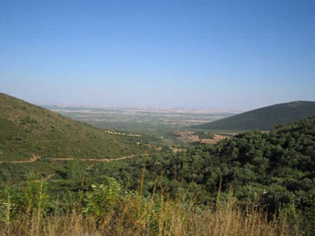
Cabañeros National Park landscape and geographic character

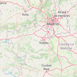
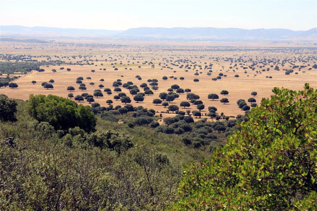
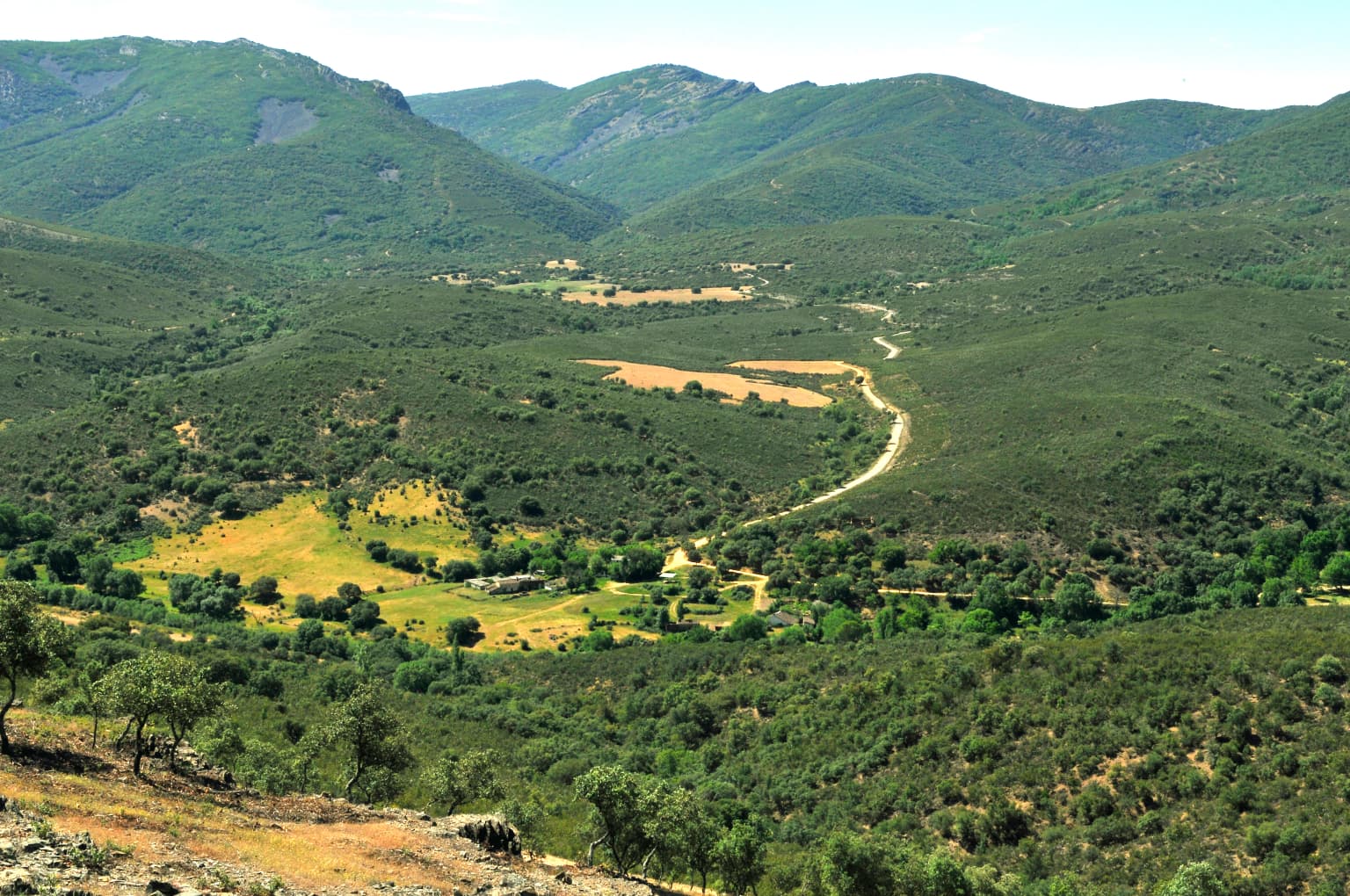
The landscape of Cabañeros National Park presents dramatic contrasts between two principal terrain types that define the Montes de Toledo region. The raña occupies the southeastern portion of the park, comprising a vast flat plain of approximately 8,000 hectares. This unique landscape originated through geological filling processes approximately three million years ago, creating soils quite different from the surrounding mountains. During the 1960s, much of the original forest and scrub was cleared for cereal cultivation, transforming the area into its current character as a grassy woodland with scattered trees, though certain areas retain original vegetation such as the Mancho del Portugués.

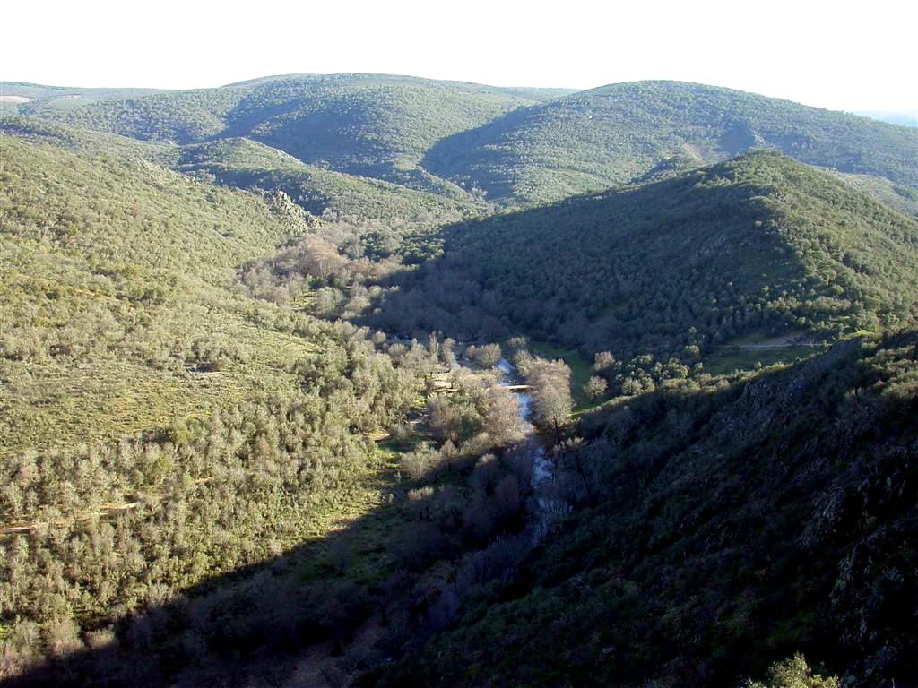
The sierras constitute the mountainous heart of the park, covering the northern, central, and western regions. These terrain features range in elevation from 650 meters to the summit of Rocigalgo at 1,448 meters. The mountain slopes support extensive forests and scrubland, with exposed rocky areas (pedrizas) creating additional habitat diversity. The Chorrito and Rocigalgo massifs dominate the western section, while the Miraflores Sierra lies to the south. The park is framed by the Bullaque River to the east and the Estena River to the west, both tributaries of the Guadiana system. This interplay of flatland and mountain, woodland and cleared areas, creates a visual and ecological diversity that distinguishes Cabañeros from other Spanish protected areas.

Close-up of pink flowering plant with green foliage in natural setting
Pink flowering Erica australis plant in natural setting

Cabañeros National Park ecosystems, habitats, and plant life

Cabañeros National Park is dedicated to the conservation of Mediterranean forest ecosystems adapted to continental Mediterranean climate with cold winters and hot, dry summers, with precipitation concentrated in spring and autumn. Four Quercus species dominate the park's vegetation, each occupying distinct ecological niches according to moisture requirements. The holm oak represents the most drought-adapted species, while cork oak and oak prefer somewhat wetter zones. The melojo oak or rebollo requires greater moisture and grows along watercourses and in higher elevations on shady north-facing slopes, utilizing atmospheric humidity.

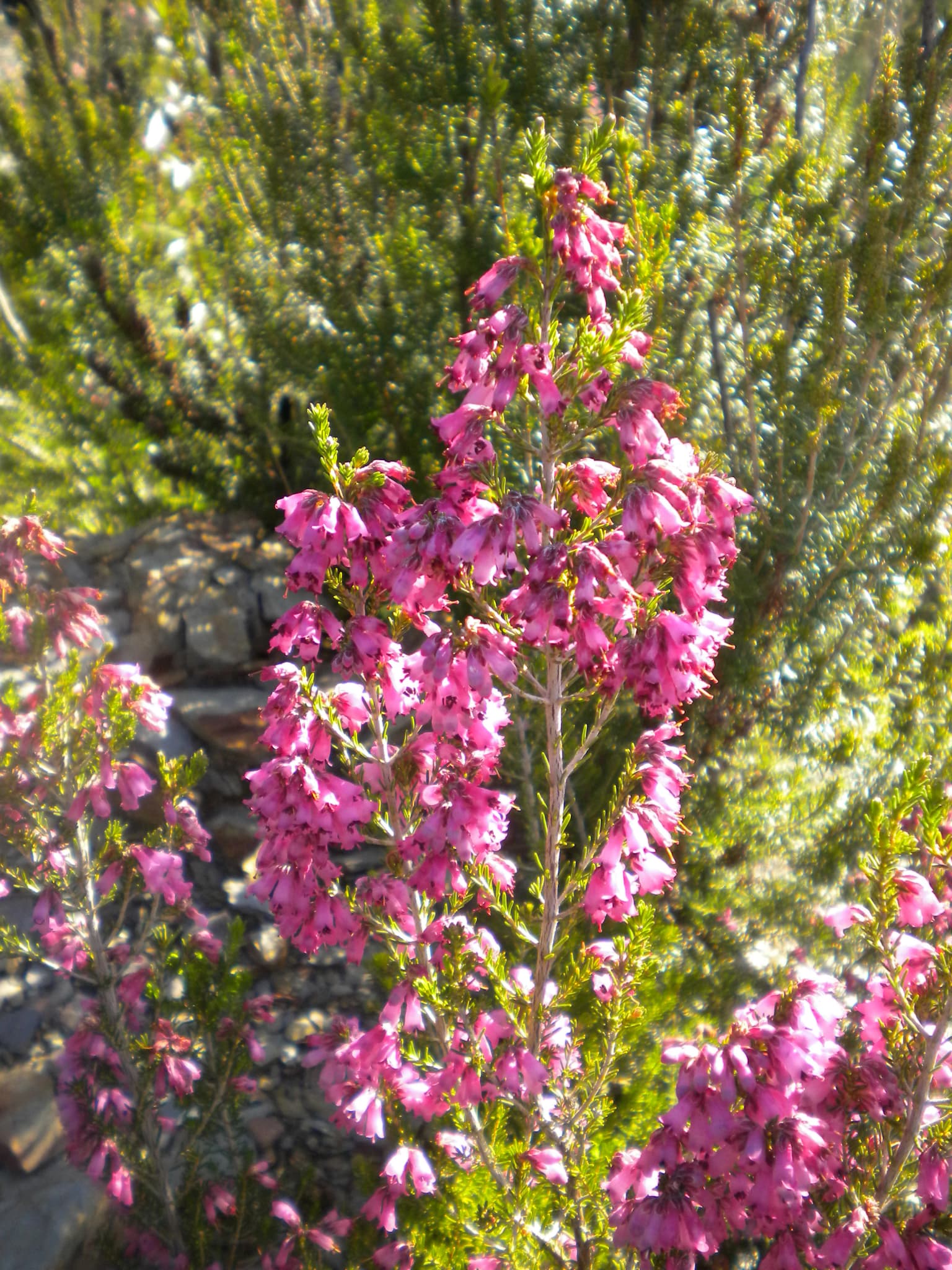
Beyond the dominant oaks, the park supports a rich understory including strawberry tree, laurustinus, and diverse shrubs such as rosemary, heathers, and rockroses that color and perfume the mountain slopes. The herbaceous layer contains notable species including several Paeonia varieties, violets, and diverse grasses. Particularly remarkable is the presence of threatened or relict species in specific microhabitats—tropical-era trees like the laurel survive in certain sheltered corners, while reminders of cooler past periods include birch, yew, and holly. Valley bottoms support peat bogs some exceeding 4,000 years in age, hosting unique flora including bog myrtle and carnivorous plants like butterworts. The park contains 17 habitats of community interest and supports approximately 550 lichen species, representing one-fifth of the Iberian Peninsula's total, reflecting excellent conservation status and environmental quality.

Panoramic view of a green valley with rolling hills, a winding road, scattered trees, and distant mountains under a clear sky
Valley of Arroyo del Chorro viewed from Las Becerras viewpoint in Cabañeros National Park

Cabañeros National Park wildlife and species highlights

The wildlife of Cabañeros reflects the park's exceptional ecological diversity, with 276 vertebrate species recorded and a notable percentage of endangered species. Mammals include European otters along the Estena River and four ungulate species: wild boar, red deer, roe deer, and fallow deer in the most forested areas. The park provides potentially suitable habitat for the critically endangered Iberian lynx, though confirmed sightings remain rare in recent years, possibly due to prey species scarcity. The Montes de Toledo have been selected for lynx reintroduction efforts through European LIFE programme projects.

The avifauna is particularly significant, with the park designated as a Special Protection Area. The Eurasian black vulture maintains one of the world's largest breeding colonies here, with over 200 pairs nesting in the large cork oaks above rocky outcrops—remarkably, the absence of cliff faces limits the presence of griffon vulture as breeders. The Spanish imperial eagle, a threatened species, nests within the park boundaries, while the black stork, though rare, uses the area. The raña flatland supports steppe bird species including larks, the calandra lark, crested lark, and short-toed lark, along with threatened species like the great bustard and red-legged partridge. Birds of prey including golden eagles, imperial eagles, booted eagles, and short-toed eagles hunt over the landscapes, with black and red kites also present.

The rivers and streams support endemic fish species including the jarabugo, calandino, and colmilleja, sharing habitat with amphibians such as the Iberian newt and common salamander. The mountainous zones provide habitat for Iberian lynx competitors including wildcat, genet, stone marten, Egyptian mongoose, and badger, all competing for the rabbit that serves as primary prey for the lynx. Higher elevations near the Rocigalgo massif support Spanish ibex and roe deer in the cool oak and ash forests.

Wide landscape view showing rolling hills and valleys covered in dense Mediterranean forest with a stream running through the valley
Panoramic view of Mediterranean forest landscape in Cabañeros National Park

Cabañeros National Park conservation status and protection priorities

Cabañeros National Park represents one of Spain's most significant conservation achievements, protecting the finest remaining example of Iberian Mediterranean forest. The park's designation as both a Zone of Special Protection for Birds (ZEPA) and a Site of Community Importance (ZEC) within the European Natura 2000 network reflects its continental importance. The 17 habitats of community interest present within the park, combined with excellent environmental quality and the absence of significant pollution, support extraordinary biodiversity including approximately 550 lichen species representing one-fifth of the Iberian Peninsula's total.

The park aims to develop sustainable tourism as part of its conservation strategy. While hunting is theoretically banned within national parks in Spain, population control hunting has been permitted in certain circumstances. The park faces ongoing conservation challenges, including a 2014 judicial case involving unauthorized firebreak creation within a hunting estate to facilitate hunting activities, resulting in fines ratified in 2017. The Montes de Toledo region has been selected as a reintroduction site for the critically endangered Iberian lynx through European LIFE programme projects, highlighting the park's role in broader species recovery efforts across the Iberian Peninsula.

Cabañeros National Park cultural meaning and human context

The name Cabañeros derives from the traditional conical huts or cabañas built by shepherds and charcoal burners as temporary shelters while working in the fields. These structures, roofed with vegetation from the surrounding environment, were used by the inhabitants of the Montes de Toledo for seasonal pastoral and forestry activities. The name thus reflects centuries of human interaction with this landscape, creating a cultural identity inseparable from the natural environment.

Human presence in the park area extends to the Lower Paleolithic, with archaeological remains found throughout the region. Bronze Age settlements, Roman and Visigothic ruins, and Islamic-period sites have been identified in the park's zone of influence. The necropolis of Malamoneda in Hontanar contains remains from Hispanoroman, Visigothic, Islamic, and Christian-medieval periods. The Los Montes region historically belonged to Toledo from the 13th to 19th centuries, with city ordinances regulating resource use and imposing taxes that, combined with difficult terrain, limited population growth and protected natural areas from intensive development. Traditional activities including charcoal production, pastoralism, agriculture, beekeeping, and cork extraction shaped both the landscape and cultural heritage that the park now preserves.

Wide landscape view showing rolling hills and valleys with a winding road, surrounded by dense Mediterranean forest under clear blue sky
View towards the south from Puerto de Los Santos in Cabañeros National Park

Top sights and standout views in Cabañeros National Park

Cabañeros stands as Spain's premier Mediterranean forest reserve, protecting the most extensive and best-conserved example of Iberian oak woodland ecosystems. The park's black vulture colony represents one of the world's largest breeding populations, with over 200 pairs nesting in ancient cork oaks. The geological heritage includes Ordovician and Cambrian fossils exceeding 400 million years, including discoveries of the oldest known giant worm. The contrasting landscape of flat raña and mountainous sierras creates ecological diversity found nowhere else in Spain. The park protects four oak species, over 1,000 vascular plant species, and 17 habitats of community interest within the Natura 2000 network.

Wooden railing and sign at a viewpoint overlooking green mountains and valley
Viewpoint with mountains and valley in Cabañeros National Park

Best time to visit Cabañeros National Park

Cabañeros can be visited throughout the year, with each season offering distinct experiences. Spring brings abundant wildflower displays across the raña and mountain slopes, with optimal conditions for birdwatching as migratory species return and resident birds become active. The moderate temperatures of spring and autumn make these seasons particularly comfortable for hiking and exploring the park's network of trails. Summer heat can be intense, though the forested areas provide shade and the early morning or late afternoon hours remain suitable for activity. Winter offers a different character, with potentially snowy conditions in the higher elevations and the opportunity to observe large deer herds moving through the raña, though visitor facilities may have reduced hours. The park receives relatively few visitors compared to other Spanish national parks, with approximately 104,000 annual visitors in 2016, making it possible to experience solitude even during peak periods.

Park location guide

Geography guide, regional context, and park location map for Cabañeros National Park

Cabañeros National Park park geography, regions, and map view in Spain
Understand where Cabañeros National Park sits in Spain through a broader geographic reading of the surrounding landscape, nearby location context, and its mapped position within the national park landscape.

How Cabañeros National Park fits into Spain

Spain, officially the Kingdom of Spain, is a unitary parliamentary constitutional monarchy located in Southern and Western Europe. The country occupies most of the Iberian Peninsula and includes territories in the Mediterranean and Atlantic. With a population of approximately 49.6 million and an area of 506,030 km², Spain is a major European economy and cultural force. Its capital is Madrid, and the country is known for its diverse landscapes ranging from mountainous regions to coastal areas.

Wider geography shaping Cabañeros National Park in Spain

Spain occupies the Iberian Peninsula in Southern and Western Europe. Peninsular Spain is bordered to the north by France, Andorra, and the Bay of Biscay; to the east and south by the Mediterranean Sea and Gibraltar; and to the west by Portugal and the Atlantic Ocean. The territory includes the Canary Islands in the Atlantic Ocean, the Balearic Islands in the Mediterranean Sea, and the autonomous cities of Ceuta and Melilla in mainland Africa. Spain features diverse terrain including the Pyrenees in the northeast, the Sierra Nevada in the south, and the Meseta Central plateau.

Map view of Cabañeros National Park

Use this park location map to pinpoint Cabañeros National Park in Spain, understand its exact geographic position, and read its mapped placement within the surrounding landscape more clearly.

Pigeon | © OpenStreetMap contributors

Location context for Cabañeros National Park

Ciudad Real ProvinceToledo Province

Explore the diverse protected landscapes of Cabañeros National Park, from vast raña plains to ancient oak woodlands and rugged sierras.

Visual Atlas of Cabañeros National Park: Explore Essential Landscapes and Protected Area Scenery
Browse the striking imagery of Cabañeros National Park to visualize its unique Iberian Mediterranean forest, expansive raña plains, and mountainous sierras, revealing the park's key ecological zones. These park photos provide essential context for understanding the varied terrain, critical habitats, and overall protected-area environment that define Spain's significant natural heritage.

Deer including adults and young fawns running across a grassy plain with scattered holm oak trees and distant mountains

Close-up of pink flowering plant with green foliage in natural setting

Panoramic view of a green valley with rolling hills, a winding road, scattered trees, and distant mountains under a clear sky

Wide landscape view showing rolling hills and valleys covered in dense Mediterranean forest with a stream running through the valley

Open grassy field with scattered trees and distant hills under a partly cloudy sky

Wide landscape view showing rolling hills and valleys with a winding road, surrounded by dense Mediterranean forest under clear blue sky

Wooden railing and sign at a viewpoint overlooking green mountains and valley

Waterfall cascading over rocky cliffs into a pool surrounded by forest vegetation

Wide landscape view of Cabañeros National Park showing open fields with scattered trees, distant mountains, and foreground vegetation

White building with red roof on grassy field with scattered trees and mountains in background

Park atlas

Browse adjacent protected landscapes and trace the regional park geography across the Montes de Toledo.

Explore Other National Parks and Protected Areas Near Cabañeros National Park
Continue your geographic exploration beyond Cabañeros National Park by browsing other protected areas and national parks across central Spain. Compare their diverse Mediterranean forest ecosystems, unique raña landscapes, and geological heritage to gain a deeper atlas perspective on regional conservation and connected natural terrain.
Watercolor illustration showing a wetland landscape with grasses, a body of water, and distant hills
National park

Tablas de Daimiel National Park: Spain's Inland Wetland National Park and Protected Area

Explore mapped boundaries and regional geographic context.

Tablas de Daimiel National Park represents one of the last remaining examples of floodplain wetland systems in Spain's interior. Located in Castilla-La Mancha, this protected area showcases a unique confluence of fresh and brackish waters, supporting a rich mosaic of emergent vegetation and serving as a critical habitat for migratory birds. Use MoriAtlas to explore its precise geographic setting, mapped terrain, and its role as a vital conservation landscape within the Iberian Peninsula.

Area
30.3 km²
Established
1973
IUCN
II
Relief
Lowland
National park

Monfragüe National Park: Protected Landscape Atlas of Spanish Raptor Colonies

Explore mapped terrain and regional geography within this Spanish National Park.

As a national park in Spain's Extremadura region, Monfragüe National Park offers a distinct protected landscape shaped by the Tagus River and dramatic limestone cliffs. It is globally recognized for its exceptional birdlife, especially its large griffon vulture colonies and populations of Spanish imperial eagles, making it a significant site for ecological study and atlas-based exploration of protected areas. The park's landscape, characterized by Mediterranean woodlands and rugged terrain, provides crucial habitat and a unique geographic context for understanding Iberian Peninsula conservation.

Scope
Terrestrial
Watercolor illustration of rolling green hills, a winding river, and a distant horizon with a soft sun
National parkExtremadura

Monfragüe National Park: Dramatic Cliffs, Raptor Haven, and Extremadura's Protected Landscape

Discover its mapped terrain and unique geography in Spain.

Monfragüe National Park, situated in Extremadura, Spain, offers a compelling study in protected landscape geography. The park's identity is shaped by its formidable cliffs and river valleys carved by the Tagus, providing critical nesting grounds for European raptors. This MoriAtlas entry details the park's mapped boundaries and its significance as a vital protected area within the region. Users can explore the specific natural terrain and regional context that establish Monfragüe as a unique protected territory.

Area
179 km²
Established
2007
IUCN
II
Visitors
331.8K annual
Watercolor illustration depicting a mountain range, river, and green vegetation under a light sky
National park

Sierra de Guadarrama National Park: Protected Area Landscape and Geographic Context

Explore diverse high Mediterranean mountain terrain and ecosystems.

Sierra de Guadarrama National Park is a significant protected national park in central Spain, characterized by its extensive granite landscapes and eleven distinct ecosystems. This park protects crucial high Mediterranean mountain environments, ancient pine forests, and dramatic glacial formations. Its geographic position within the Sistema Central makes it essential for understanding the regional geography and mapped terrain of the Iberian Peninsula, offering a unique look at a vital protected landscape.

Area
339.6 km²
Established
2013
IUCN
II
Visitors
3M annual
Watercolor illustration of a landscape with green hills, scattered trees, and distant mountains under a pink and yellow sky
Protected landscapePortalegre District

Serra de São Mamede Natural Park: A Protected Landscape Defined by Ecological Transition

Explore the unique mountain terrain and ecosystems of Portalegre District.

Delve into the geographic and ecological identity of Serra de São Mamede Natural Park, a significant protected landscape situated in Portugal's Portalegre District. This area is renowned for its dramatic quartzite ridges and its role as a crucial meeting point for Atlantic and Mediterranean plant communities, offering a unique atlas perspective on regional biodiversity. Examining its mapped boundaries and diverse terrain provides essential context for understanding its ecological importance and its distinct position within the Alentejo region's geography.

Area
560.6 km²
Established
1989
IUCN
V
Visitors
4.5K annual
National parkAndalusia

Sierra Nevada National Park: Protected Alpine Terrain and Geographic Context in Andalusia

Explore Spain's highest mountain range mapped across Andalusia's atlas.

Sierra Nevada National Park offers a profound exploration of Spain's highest alpine environments and a significant entry in the regional geography atlas. This protected area showcases classic glacial landforms, U-shaped valleys, and numerous high-mountain lakes, alongside a remarkable abundance of endemic plant species thriving in its unique microclimates. Understanding its mapped boundaries reveals a landscape vital for both biodiversity and watershed, situated prominently within the broader geographic context of Andalusia.

Area
858.83 km²
Established
1999
IUCN
II
Relief
Mountain
Watercolor illustration of a landscape with green mountains, a body of water, and colorful wildflowers in the foreground
Nature reservePortugal

Serra da Estrela Natural Park: Glacial Terrain and Highest Peaks in Portugal

Explore the dramatic geography of this nature reserve.

Serra da Estrela Natural Park is a significant protected landscape in Portugal, celebrated for containing the nation's highest peak and exceptional Quaternary glacial formations. The park's terrain includes dramatic valleys carved by ice, numerous glacial lakes, and a stark alpine plateau around Torre. This nature reserve preserves a unique environment shaped by both geological history and traditional pastoralism, offering rich mapped context for understanding Portugal's mountainous geography and protected areas.

Area
891.32 km²
Established
1976
IUCN
V
Visitors
7.6K annual
National park

Sierra de las Nieves National Park: Ancient Fir Forests and Karst Geography in Andalusia

Mapped protected landscape and unique geologic features

Sierra de las Nieves National Park stands as a remarkable protected area in Andalusia, Spain, celebrated for its world-leading Spanish fir forests and intricate karst topography. This national park showcases significant geological diversity, from towering limestone formations and deep caves to the striking red peridotite mountains of Sierra Bermeja. Its elevation, reaching Pico Torrecilla at 1,919 meters, offers a unique alpine landscape context within southern Europe, mapped for detailed geographic discovery and protected area exploration.

Area
939.3 km²
Established
1989
IUCN
II
Visitors
100K annual

Common questions about visiting, size, designation, and location context for Cabañeros National Park

Cabañeros National Park FAQs for park facts, access, geography, and protected area context
Find quick answers about Cabañeros National Park, including protected-area facts, park geography, trail and visitor context, and how the park fits into its surrounding country and regional landscape.
MoriAtlas Explorer

Continue Your Protected Areas Search Across the Global Atlas

Deepen your exploration by continuing the structured search for national parks and protected areas worldwide. Utilize the comprehensive filtering capabilities to compare different conservation landscapes and refine your understanding of global park geography. Discover more about the distribution and characteristics of protected natural areas.

Global natural geography