Mori Atlas logo
Protected landscapeRia Formosa Natural Park

Mapping the unique geography and protected landscape context of this key Portuguese natural area.

Ria Formosa Natural Park: Protected Landscape in Portugal's Algarve Region

(Parque Natural da Ria Formosa)

Discover Ria Formosa Natural Park, a protected landscape situated within the Algarve region of southern Portugal. This page offers an atlas-driven perspective, focusing on the park's geographic identity, its mapped boundaries, and its significance as a protected natural area. Understand its role in the regional landscape and explore its place within the broader geographical context of Portugal through detailed, factual content.

Coastal LagoonWetlandBarrier IslandsBird MigrationRamsar SiteIUCN Category V

Ria Formosa Natural Park

Protected landscape

Park overview

Structured park overview, official facts, and landscape profile for Ria Formosa Natural Park

Ria Formosa Natural Park park facts, protected area profile, and essential visitor context
Review the core facts for Ria Formosa Natural Park, including designation, size, terrain, visitor scale, habitats, and operating context in one park-focused overview.

About Ria Formosa Natural Park

Ria Formosa Natural Park represents one of Portugal's most significant coastal protected areas, encompassing a complex and dynamic lagoon system that has shaped the ecological and cultural landscape of the Algarve for centuries. The park's geography centers on a series of barrier islands that form a natural barrier between the Atlantic Ocean and the sheltered lagoon waters behind them. This configuration creates an exceptionally diverse habitat mosaic that includes tidal marshes, sand dunes, shallow water channels, and expansive salt marsh areas. The six inlets that connect the lagoon to the sea have historically been mobile features, with natural sand movements regularly altering their positions and configurations. The only artificial inlet, the Faro-Olhão channel, was created through engineering works that began in 1927 and reached completion in 1952, fundamentally altering the system's hydrology and establishing the current configuration that serves as the primary navigation route for the region. Beyond its ecological significance, Ria Formosa has long supported the economic activities of surrounding communities, particularly through aquaculture operations focused on the grooved carpet shell and traditional fishing practices. The proximity of major cities like Tavira, Faro, and Olhão has created a landscape where natural ecosystems coexist with human settlement and tourism infrastructure, making the park an integral component of the regional identity and economy.

Quick facts and research context for Ria Formosa Natural Park

Ria Formosa Natural Park occupies a coastal position in the southernmost portion of continental Portugal within the Algarve region. The protected area encompasses roughly 179 square kilometers of lagoon, marshland, and barrier island ecosystems. The park was established in 1978 and is governed by ICNF, the Institute for Nature Conservation and Forests. It holds dual international designations as a Ramsar Wetland site and an Important Bird Area recognized by BirdLife International, with the lagoon covering 23,296 hectares and an additional oceanic zone of 19,900 hectares. The system features six sea inlets, five natural and one artificial, with the Faro-Olhão inlet being the primary navigation channel. Major nearby urban centers include Tavira, Faro, and Olhão.

Park context

Deeper park guide and search-rich context for Ria Formosa Natural Park

Ria Formosa Natural Park history, landscape, wildlife, and travel context
Explore Ria Formosa Natural Park through its history, landscape character, ecosystems, wildlife, conservation priorities, cultural context, and seasonal travel timing in a structured park guide built for atlas discovery and search intent.

Why Ria Formosa Natural Park stands out

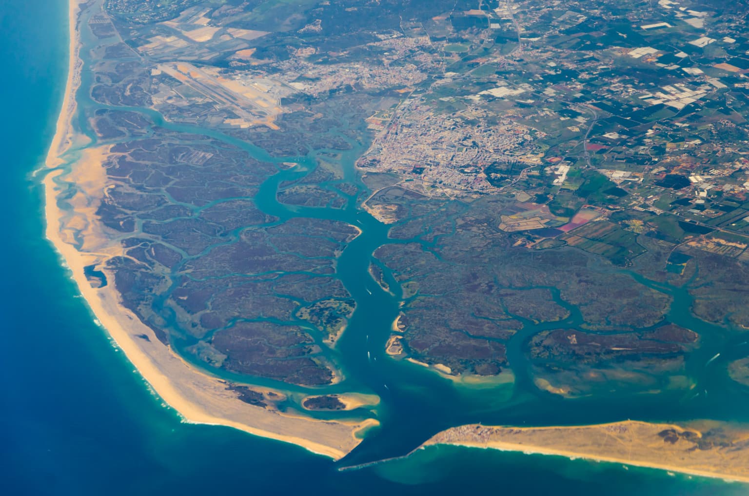
Ria Formosa is best known for its extraordinary coastal lagoon ecosystem that supports one of Europe's most important migratory bird corridors. The wetland serves as a vital stopping ground for thousands of birds during their seasonal migrations between northern Europe and Africa, with approximately 30,000 birds observable annually from the park. The system also contains some of the last remaining nesting grounds in Europe for certain bird species. The park's distinctive barrier islands, including Armona, Barreta, Cacela, Culatra, and Tavira Islands, create a unique landscape of sandy beaches, tidal channels, and marsh habitats. In 2010, the lagoon was recognized as one of Portugal's seven natural wonders, winning the Marine Area category of the national '7 Maravilhas Naturais de Portugal' competition following a public vote that attracted over 656,000 participants.

Ria Formosa Natural Park history and protected-area timeline

Ria Formosa's history as a protected area began in 1978 when the Portuguese government established the Natural Park to preserve the lagoon's exceptional ecological values and regulate human activities within the fragile coastal system. The creation of the protected area reflected growing awareness of the lagoon system's importance both for biodiversity conservation and for sustaining the traditional economic activities of surrounding communities. The Ramsar Convention designation in 1980 further cemented the park's international recognition, as Portugal joined the global network of wetland sites of importance. The artificial opening and maintenance of the Faro-Olhão inlet represents perhaps the most significant historical intervention in the system's natural dynamics, with engineering works spanning from 1927 to 1952. This artificial channel fundamentally changed tidal circulation patterns and sediment transport within the lagoon, while also facilitating maritime access to the port of Faro. The 2010 recognition as one of Portugal's seven natural wonders, achieved through a nationwide public vote, brought renewed attention to the park's conservation value and its role as a defining feature of the Algarve landscape.

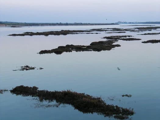
Ria Formosa Natural Park landscape and geographic character

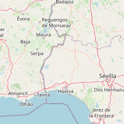
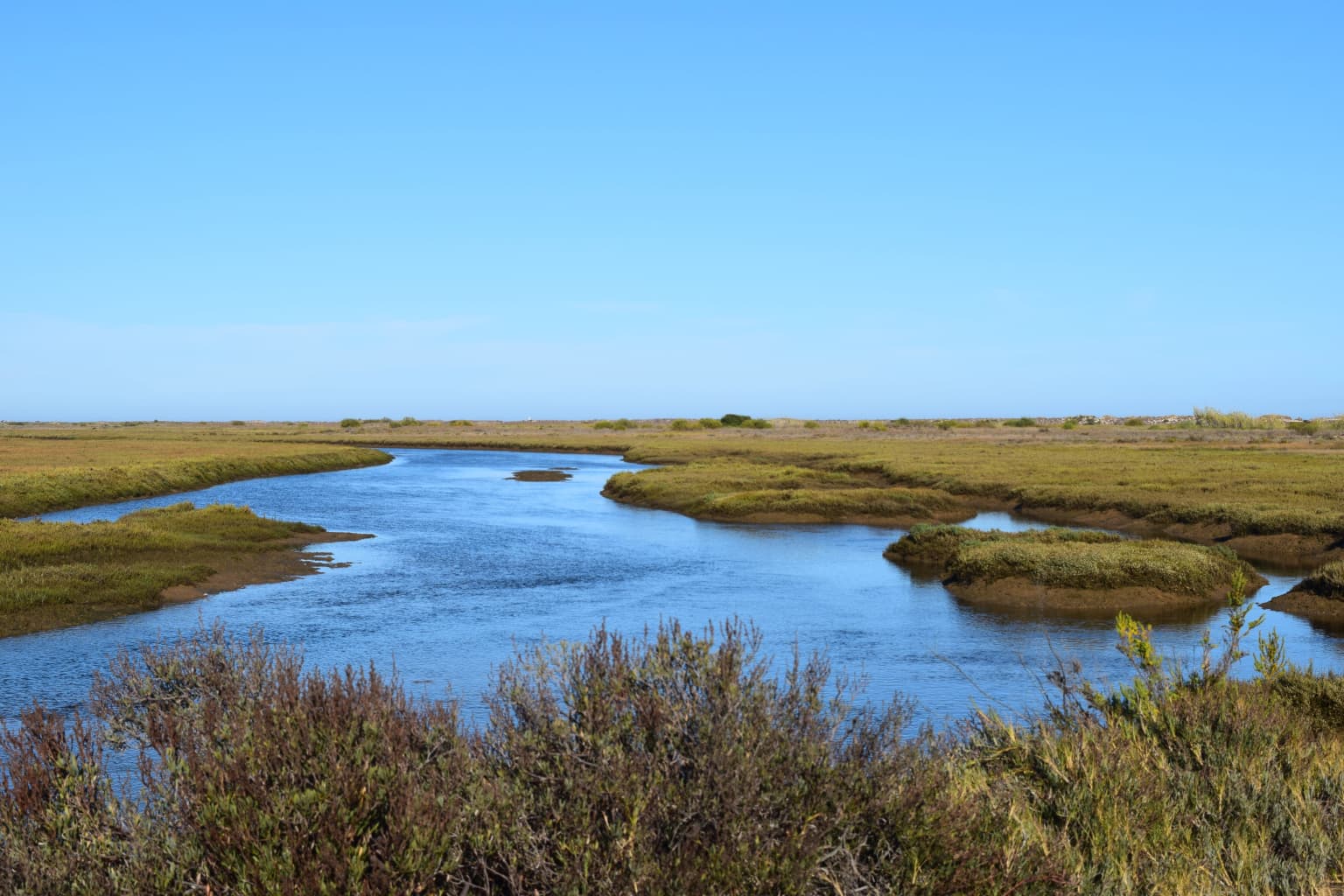
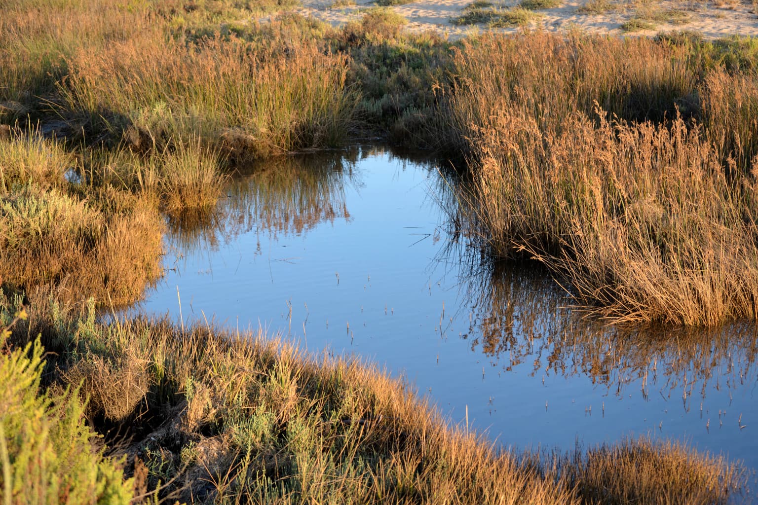
The physical landscape of Ria Formosa Natural Park is characterized by its distinctive coastal lagoon geometry, where a chain of barrier islands parallel the mainland coast, creating a shallow, sheltered water body between the islands and the shoreline. The barrier islands, including Armona, Barreta, Cacela, Culatra, and Tavira Islands, are composed primarily of sand deposits that have accumulated over millennia through coastal sediment transport processes. These islands support beach ecosystems and are partially vegetated with salt-tolerant plant communities adapted to the harsh coastal environment. Behind the island chain, the lagoon encompasses extensive tidal marsh areas that flood and drain with the twice-daily tidal cycle, creating a dynamic environment of mudflats, salt pans, and vegetated marshland. The six inlets that punctuate the barrier islands serve as the primary connection points between the lagoon and the ocean, with five maintaining natural dynamics while the Faro-Olhão inlet represents the artificial human-modified channel. The surrounding mainland terrain is relatively flat, supporting agricultural land use and urban development in the communities of Tavira, Faro, Olhão, and smaller settlements like Cabanas de Tavira, Santa Luzia, and Cacela Velha.

Ria Formosa Natural Park ecosystems, habitats, and plant life

The ecological character of Ria Formosa Natural Park centers on its coastal lagoon ecosystem, which supports extraordinarily high biodiversity relative to its relatively modest geographic extent. The intertidal zones of the lagoon provide critical feeding and resting habitat for numerous waterbird species, while the surrounding marshes and islands offer nesting opportunities for breeding populations. The park's designation as an Important Bird Area by BirdLife International reflects the site significance for bird populations, with the lagoon area covering 23,296 hectares and an additional oceanic zone of 19,900 hectares contributing to the overall protected boundary. The seasonal migration cycles bring thousands of birds through the park each year, with spring and autumn periods seeing the highest numbers of transiting individuals. The lagoon also supports diverse marine and brackish water communities, including fish species that use the sheltered waters as nursery habitat and shellfish populations that have historically supported aquaculture activities in the region.

Ria Formosa Natural Park wildlife and species highlights

The wildlife of Ria Formosa is dominated by its exceptional bird populations, which represent the park's most significant ecological value and the primary reason for its international conservation recognition. The lagoon system serves as a crucial refueling station and resting area for migratory waterfowl traveling between breeding grounds in northern Europe and wintering areas in Africa. An estimated 30,000 birds can be observed from the park annually, though this number represents only a portion of the total individuals that pass through the system during migration periods. The wetland contains some of the last remaining nesting grounds in Europe for certain bird species, making it particularly important for breeding populations that have declined elsewhere on the continent. Beyond birds, the lagoon supports fish communities, shellfish populations including the commercially important grooved carpet shell, and various invertebrate species that form the base of the coastal food web. The marine waters around the barrier islands host additional species adapted to sandy and rocky subtidal environments.

Ria Formosa Natural Park conservation status and protection priorities

Ria Formosa Natural Park occupies a critical position in European coastal conservation, with its dual designations as a Ramsar Wetland and an Important Bird Area reflecting the site's international significance. The Ramsar Convention designation, awarded in November 1980, recognizes the lagoon as a wetland of international importance, particularly for waterbird habitat and biodiversity conservation. BirdLife International's Important Bird Area designation further emphasizes the site's value for bird conservation, with the area supporting both migratory populations and breeding species. The park's classification as an IUCN Category V protected landscape reflects its mixed conservation and sustainable use values, where ecological protection coexists with human activities including tourism, aquaculture, and traditional fishing. The challenge of managing this dynamic coastal system involves balancing ecological preservation with the economic needs of surrounding communities, particularly as development pressure increases across the Algarve region.

Ria Formosa Natural Park cultural meaning and human context

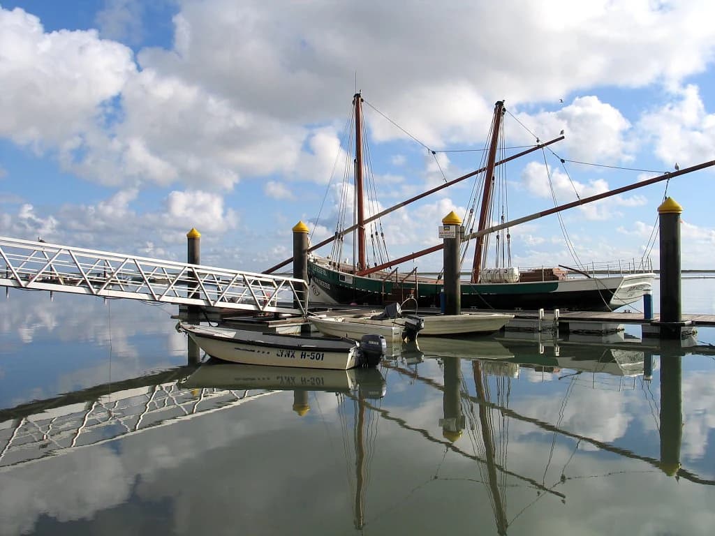
The cultural landscape of Ria Formosa reflects centuries of human interaction with the coastal lagoon environment, as surrounding communities have developed maritime traditions, fishing practices, and aquaculture operations intimately connected to the ecosystem. The towns of Tavira, Faro, and Olhão have historical connections to the lagoon that predate the modern protected area, with fishing and shellfishing forming the economic foundation of these communities. The creation of the artificial Faro-Olhão inlet in the mid-20th century represents a significant human modification to the natural system, demonstrating the long history of engineering interventions in this dynamic coastal environment. Traditional salt production, fishing, and more recently shellfish aquaculture continue to shape the cultural identity of the region, even as tourism has become increasingly important to the local economy. The barrier island communities and small settlements such as Cabanas de Tavira, Cacela Velha, and Santa Luzia maintain connections to the lagoon through fishing and tourism activities.

Top sights and standout views in Ria Formosa Natural Park

The Ria Formosa lagoon system stands as a premier example of Mediterranean coastal wetland ecology, offering visitors and researchers alike access to one of Europe's most important migratory bird corridors. The park's six barrier islands, including Armona, Barreta, Cacela, Culatra, and Tavira Islands, provide diverse recreational opportunities from naturist beaches at Barril to established beach facilities at Tavira Island with its campsite. The seasonal bird migrations represent perhaps the park's most spectacular natural phenomenon, with spring and autumn bringing thousands of wading birds, waterfowl, and seabirds through the lagoon system. The 2010 recognition as one of Portugal's seven natural wonders demonstrates the strong emotional and cultural connection that Portuguese citizens have with this coastal ecosystem. The combination of natural beauty, ecological significance, and accessibility from major population centers makes Ria Formosa a cornerstone of conservation in southern Portugal.

Best time to visit Ria Formosa Natural Park

Ria Formosa Natural Park can be visited throughout the year thanks to the Algarve's mild climate and sunny weather, though certain seasons offer distinct advantages for different experiences. Spring and autumn represent peak periods for wildlife observation, as these seasons coincide with the major migratory bird passages when thousands of birds stop to rest and feed in the lagoon. Birdwatchers will find these periods particularly rewarding, with the chance to observe diverse species in significant numbers as they traverse the Mediterranean flyway. Summer months bring the highest temperatures and largest tourist crowds, with beach activities on the barrier islands reaching their peak, though the marsh areas remain accessible and the lagoon waters provide cooling breezes. Winter offers a quieter experience with fewer visitors, though bird populations remain present and the milder temperatures make outdoor exploration comfortable. The year-round accessibility of the park's beaches and the connected communities means that any visit can be rewarding, depending on whether the priority is wildlife observation, beach recreation, or experiencing the cultural life of the surrounding towns.

Park location guide

Geography guide, regional context, and park location map for Ria Formosa Natural Park

Ria Formosa Natural Park park geography, regions, and map view in Portugal
Understand where Ria Formosa Natural Park sits in Portugal through a broader geographic reading of the surrounding landscape, nearby location context, and its mapped position within the national park landscape.

How Ria Formosa Natural Park fits into Portugal

Portugal is a developed European country on the western Iberian Peninsula. It features a coastline along the Atlantic Ocean, includes the autonomous regions of the Azores and Madeira, and is known for its maritime history during the Age of Discovery. The country has a population of over 10.7 million and operates as a semi-presidential republic with Portuguese as its official language.

Wider geography shaping Ria Formosa Natural Park in Portugal

Portugal occupies the western portion of the Iberian Peninsula in Southwestern Europe. The mainland borders Spain to the north and east, while the autonomous regions of Madeira and the Azores are situated in the Atlantic Ocean. The country includes Cabo da Roca, the westernmost point in continental Europe. The terrain varies from plains in the south to mountainous regions in the north.

Map view of Ria Formosa Natural Park

Use this park location map to pinpoint Ria Formosa Natural Park in Portugal, understand its exact geographic position, and read its mapped placement within the surrounding landscape more clearly.

Pigeon | © OpenStreetMap contributors

Location context for Ria Formosa Natural Park

Algarve
Park atlas

Compare national parks and protected areas near Ria Formosa Natural Park, exploring connected coastal ecosystems and regional park geography.

Explore More Protected Areas Near Ria Formosa Natural Park, Portugal
After exploring Ria Formosa Natural Park's unique coastal lagoon system, browse a curated list of other protected areas, national parks, and related conservation landscapes across the Algarve region and beyond. This allows for direct geographic comparison, tracing connected ecosystems and understanding the broader protected-area spread in southern Portugal through an atlas-style lens.
Watercolor illustration showing a river flowing through a valley with hills and vegetation
Protected landscapeBeja District

Guadiana Valley Natural Park: Protected Landscape Discovery in Beja District

Explore its mapped geography and protected land context.

Guadiana Valley Natural Park is identified as a protected landscape, providing a specific focus for geographic study and map-based exploration. This entry details the park's unique protected-area status and its contextual placement within the expansive Beja District of southern Portugal. Understand the mapped boundaries and landscape features that define this area, serving as a key point for regional geographic understanding on MoriAtlas.

Area
697 km²
Established
1995
IUCN
V
Visitors
749 annual
Protected landscapeAlentejo Litoral

Southwest Alentejo and Vicentine Coast Natural Park: A Protected Landscape in Alentejo Litoral

Explore its mapped boundaries and regional geographic context.

This detail page offers a deep dive into the Southwest Alentejo and Vicentine Coast Natural Park, a protected landscape situated in Portugal's Alentejo Litoral region. Understand the park's identity as a protected area through its geographic features and mapped extent. MoriAtlas facilitates a structured understanding of this natural landscape, enabling focused discovery of its protected boundaries and regional geographical significance.

Area
895.7 km²
Established
1988
IUCN
V
Visitors
12.7K annual
National parkHuelva

Doñana National Park National Park: Mapped Geography and Protected Landscape Context

Explore Huelva's key protected area and its regional geographic setting.

Delve into the structured geographic data and mapped boundaries of Doñana National Park. This entry highlights its identity as a national park within the Huelva region, providing essential context for understanding its protected landscape. MoriAtlas offers this detail to facilitate a clear, atlas-driven exploration of its natural terrain and its place in the broader geographic framework of Spain.

Area
543 km²
Established
1969
IUCN
II
Visitors
376.3K annual
Protected landscapePortugal

Arrábida Natural Park: Protected Landscape Atlas and Geographic Context in Portugal

Mapped boundaries of this key Portuguese protected area.

Arrábida Natural Park is presented here as a significant protected landscape, offering rich details for geographic exploration and atlas-based research. Users can investigate its specific mapped boundaries, understand its environmental setting within Portugal, and utilize this data for comparative analysis of protected areas. This resource focuses on the park's inherent geographic identity and its role as a defined natural landscape.

Area
176.41 km²
Established
1976
IUCN
V
Visitors
23.1K annual
Watercolor painting showing rolling coastal hills with green vegetation, a body of water, and distant mountains under a light sky
Protected landscapeLisbon District

Sintra-Cascais Natural Park: Mapped Protected Landscape in Lisbon District, Portugal

Explore Atlantic coast geography and historic palatial terrain.

The Sintra-Cascais Natural Park is a designated protected landscape in Portugal's Lisbon District, renowned for its fusion of natural beauty and historical architecture. This page offers an atlas-style exploration of its mapped boundaries, showcasing the unique Serra de Sintra mountain range meeting the Atlantic coast. Discover the protected area's geographic features, from its lush forested slopes crowned with iconic palaces to the dramatic cliffs and beaches of Cabo da Roca, providing essential context for understanding this distinctive Portuguese natural landscape.

Area
144.51 km²
Established
1981
IUCN
V
Visitors
43.5K annual
National park

Sierra de las Nieves National Park: Ancient Fir Forests and Karst Geography in Andalusia

Mapped protected landscape and unique geologic features

Sierra de las Nieves National Park stands as a remarkable protected area in Andalusia, Spain, celebrated for its world-leading Spanish fir forests and intricate karst topography. This national park showcases significant geological diversity, from towering limestone formations and deep caves to the striking red peridotite mountains of Sierra Bermeja. Its elevation, reaching Pico Torrecilla at 1,919 meters, offers a unique alpine landscape context within southern Europe, mapped for detailed geographic discovery and protected area exploration.

Area
939.3 km²
Established
1989
IUCN
II
Visitors
100K annual
Watercolor illustration of a landscape with green hills, scattered trees, and distant mountains under a pink and yellow sky
Protected landscapePortalegre District

Serra de São Mamede Natural Park: A Protected Landscape Defined by Ecological Transition

Explore the unique mountain terrain and ecosystems of Portalegre District.

Delve into the geographic and ecological identity of Serra de São Mamede Natural Park, a significant protected landscape situated in Portugal's Portalegre District. This area is renowned for its dramatic quartzite ridges and its role as a crucial meeting point for Atlantic and Mediterranean plant communities, offering a unique atlas perspective on regional biodiversity. Examining its mapped boundaries and diverse terrain provides essential context for understanding its ecological importance and its distinct position within the Alentejo region's geography.

Area
560.6 km²
Established
1989
IUCN
V
Visitors
4.5K annual
Watercolor illustration of a landscape with rolling hills, a body of water, and vegetation
Protected landscapePortugal

Aire and Candeeiros Ranges Natural Park: Protected Landscape and Regional Geographic Context

Explore the mapped boundaries and natural landscape of this Portuguese protected area.

Understand the Aire and Candeeiros Ranges Natural Park as a key protected landscape in Portugal. This page offers detailed geographic information, focusing on the park's mapped boundaries and its intrinsic connection to the surrounding regional geography. It serves as a portal for atlas exploration, providing structured data for users interested in the specific protected area and its landscape characteristics within the Iberian Peninsula.

Area
383.93 km²
Established
1979
IUCN
V
Visitors
31.9K annual

Common questions about visiting, size, designation, and location context for Ria Formosa Natural Park

Ria Formosa Natural Park FAQs for park facts, access, geography, and protected area context
Find quick answers about Ria Formosa Natural Park, including protected-area facts, park geography, trail and visitor context, and how the park fits into its surrounding country and regional landscape.
MoriAtlas Explorer

Continue Your Protected Areas Search Across the Global Atlas

Deepen your exploration by continuing the structured search for national parks and protected areas worldwide. Utilize the comprehensive filtering capabilities to compare different conservation landscapes and refine your understanding of global park geography. Discover more about the distribution and characteristics of protected natural areas.

Global natural geography