Mori Atlas logo
National parkBen Halls Gap National Park

Discover a protected landscape defined by its significant old-growth woodland and rugged terrain.

Ben Halls Gap National Park: Australia's Ancient Eucalyptus Forest National Park

Ben Halls Gap National Park, situated in New South Wales, Australia, is a significant protected area encompassing approximately 30 square kilometers of rugged terrain dominated by ancient eucalyptus forests. This national park serves as a vital natural laboratory, with its strict nature reserve status prioritizing ecological preservation and scientific research. Its landscape offers a glimpse into Australia's valuable old-growth woodland ecosystems, situated within the broader geographic context of the Northern Tablelands.

National ParkStrict Nature ReserveEucalyptus ForestOld-Growth ForestNorthern TablelandsNew South Wales

Ben Halls Gap National Park

National park

Park overview

Structured park overview, official facts, and landscape profile for Ben Halls Gap National Park

Ben Halls Gap National Park park facts, protected area profile, and essential visitor context
Review the core facts for Ben Halls Gap National Park, including designation, size, terrain, visitor scale, habitats, and operating context in one park-focused overview.

About Ben Halls Gap National Park

Ben Halls Gap National Park occupies a significant position in New South Wales's protected area network as one of the state's strict nature reserves. Located in the Northern Tablelands region, the park protects a landscape characterized by ancient eucalyptus forests that have persisted for generations, representing some of the most intact woodland environments in the area. The park's establishment in 1995 reflected growing recognition of the ecological importance of these older forest environments and the need to provide them with the highest level of protection available under Australian conservation frameworks. The strict nature reserve classification means that the park is managed with a primary focus on preserving natural processes and biodiversity, with human intervention minimized wherever possible. This approach ensures that the ancient forests can continue to function as they have for millennia, supporting the species and ecological processes that depend on these mature woodland environments.

Quick facts and research context for Ben Halls Gap National Park

Ben Halls Gap National Park covers 30.18 square kilometers in the Northern Tablelands of New South Wales, Australia. The park was established in 1995 and is classified as an IUCN Category Ia strict nature reserve, one of the most protected categories in the international protected area system. The landscape features ancient eucalyptus forests of significant ecological value, with the park situated at coordinates 31°37′11″S 151°11′06″E. The area is managed by the National Parks and Wildlife Service (NSW), with nearby communities including Nundle, Murrurundi, and Quirindi.

Park context

Deeper park guide and search-rich context for Ben Halls Gap National Park

Ben Halls Gap National Park history, landscape, wildlife, and travel context
Explore Ben Halls Gap National Park through its history, landscape character, ecosystems, wildlife, conservation priorities, cultural context, and seasonal travel timing in a structured park guide built for atlas discovery and search intent.

Why Ben Halls Gap National Park stands out

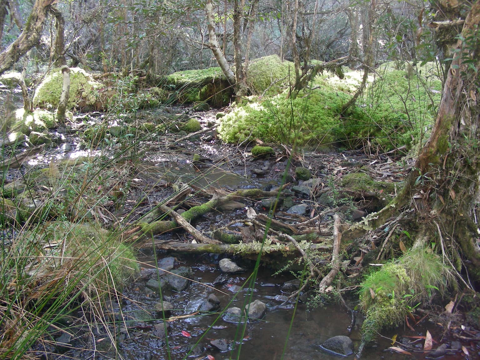
Ben Halls Gap National Park is best known for its extraordinary ancient eucalyptus forests, which constitute one of the park's most distinctive and ecologically significant features. These forests represent mature, old-growth woodland environments that have developed over very long timeframes, supporting complex ecological relationships and providing habitat for numerous species. The strict nature reserve designation reflects the exceptional ecological value of these ancient forests and the importance of preserving them in a largely unmodified state. As a Category Ia protected area, the park is managed primarily for biodiversity conservation rather than visitor access, ensuring these ancient woodland ecosystems remain as close to their natural state as possible.

Ben Halls Gap National Park history and protected-area timeline

Ben Halls Gap National Park was established in 1995 through the formal declaration of protected area status by the New South Wales government. The creation of the park reflected an expanding commitment to nature conservation in Australia during the 1990s, a period when numerous protected areas were declared across the state to preserve remaining wilderness and significant ecological environments. The selection of this area for protection acknowledged both the biological importance of the ancient eucalyptus forests and the relatively intact nature of the landscape compared to more heavily modified surrounding regions. The park was assigned IUCN Category Ia status, placing it among the most strictly protected areas in Australia and recognizing its importance as a strict nature reserve where ecosystem processes are allowed to continue with minimal human disturbance. Management responsibility rests with the National Parks and Wildlife Service of New South Wales, which administers the reserve according to strict nature reserve guidelines that prioritize conservation over other uses.

Ben Halls Gap National Park landscape and geographic character

The landscape of Ben Halls Gap National Park features the characteristic terrain of the Northern Tablelands, an elevated region in inland New South Wales. The park encompasses rugged terrain typical of this part of eastern Australia, with the ancient eucalyptus forests forming the dominant vegetation cover across much of the area. These forests grow on soils derived from the underlying geology of the region, with the trees representing various eucalyptus species adapted to the tableland environment. The landscape would have been shaped by the erosional processes that created the undulating terrain of the Northern Tablelands over geological time, with the forests now occupying ridges, slopes, and valleys throughout the park. The ancient character of these eucalyptus forests means the landscape supports trees of considerable age, creating a visually distinctive environment quite different from younger or more modified woodland elsewhere in the region.

Ben Halls Gap National Park ecosystems, habitats, and plant life

The nature of Ben Halls Gap National Park is defined primarily by its ancient eucalyptus forests, which represent mature woodland ecosystems of considerable ecological complexity. These forests have developed over very long periods, allowing for the accumulation of features that characterize old-growth environments, including diverse tree age classes, standing dead trees, fallen logs, and complex canopy structures. The eucalyptus-dominated vegetation provides the foundation for a range of ecological relationships, with the forests supporting invertebrate communities, birds, mammals, and other organisms that have evolved to depend on these woodland environments. The strict nature reserve status ensures that these ecological processes continue with minimal interruption, allowing natural fluctuations in species populations and ecological dynamics to proceed without management intervention. The protection of such environments is particularly important in a regional context where much of the original vegetation has been cleared or modified for agriculture and other human uses.

Ben Halls Gap National Park wildlife and species highlights

The ancient eucalyptus forests of Ben Halls Gap National Park support wildlife populations associated with mature woodland environments in eastern Australia. Eucalyptus forests are known to support diverse bird communities, including various honeyeaters, parrots, and passerine species that utilize the different canopy layers and foraging resources provided by the trees. Mammals including arboreal species such as possums and gliders would utilize the hollows and foraging opportunities found in the older trees, while ground-dwelling mammals occupy the forest floor and understory layers. The presence of fallen logs and dead standing trees provides important habitat for invertebrates, reptiles, and small mammals, creating a complex habitat structure that supports ecological diversity. The strict protection afforded to the park ensures these wildlife communities can persist in an environment largely free from the pressures that affect more accessible and heavily used areas.

Ben Halls Gap National Park conservation status and protection priorities

Ben Halls Gap National Park represents an important conservation outcome for the protection of old-growth eucalyptus forest in the Northern Tablelands region of New South Wales. The assignment of IUCN Category Ia status as a strict nature reserve places the park among the most strictly protected areas in the national parks system, reflecting the high ecological value of its ancient forests. This level of protection ensures that the woodland ecosystems are maintained in a largely unmodified state, with management focused on preserving natural ecological processes rather than providing public recreation opportunities. The conservation significance of such old-growth forests lies in their role as reference ecosystems that demonstrate the structure and function of woodlands that have developed without intensive human intervention. These environments also serve as repositories of biological diversity, providing habitat for species that depend on the specific features of mature eucalyptus woodland that cannot be replicated in younger forest plantings or secondary growth areas.

Ben Halls Gap National Park cultural meaning and human context

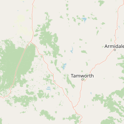
Ben Halls Gap National Park is situated in the Northern Tablelands of New South Wales, a region that has been home to Indigenous communities for tens of thousands of years. The traditional lands of Aboriginal peoples would have encompassed the area now within the park, with the eucalyptus forests and associated environments providing resources and cultural connections for local Indigenous communities. The landscape of the Northern Tablelands holds significance in Aboriginal cultural narratives and traditional land management practices that shaped the environment over millennia. While the formal protected area was only declared in 1995, the ecological values that led to the park's establishment are deeply connected to the long history of Indigenous stewardship of these lands. The surrounding area includes villages such as Nundle and Murrurundi and the town of Quirindi, communities that maintain connections to the broader landscape of which the park forms a part.

Top sights and standout views in Ben Halls Gap National Park

The defining highlight of Ben Halls Gap National Park is its extraordinary ancient eucalyptus forests, which represent some of the most significant old-growth woodland remaining in the Northern Tablelands region. The strict nature reserve status ensures these forests are protected at the highest level available, with management focused on preserving their ecological integrity for scientific and conservation purposes. The park provides an important reference environment for understanding how eucalyptus forest ecosystems function in the absence of significant human disturbance, offering opportunities for research into old-growth forest dynamics and biodiversity patterns. Located approximately 251 kilometers north of Sydney, the park sits in a landscape where much of the original vegetation has been modified, making the protected forests within the park increasingly valuable as refugia for woodland-dependent species.

Best time to visit Ben Halls Gap National Park

Ben Halls Gap National Park operates under strict nature reserve guidelines that limit public access and use. As an IUCN Category Ia protected area, the park is managed primarily for conservation rather than recreation, and visitors should check with the National Parks and Wildlife Service regarding access arrangements and permitted activities before planning any visit. The Northern Tablelands experiences temperate seasonal patterns, with cooler temperatures in winter and warmer conditions during summer months. The ancient eucalyptus forests can be appreciated across seasons, though the strict nature reserve status means that visitation opportunities may be limited regardless of when one plans to visit.

Park location guide

Geography guide, regional context, and park location map for Ben Halls Gap National Park

Ben Halls Gap National Park park geography, regions, and map view in Australia
Understand where Ben Halls Gap National Park sits in Australia through a broader geographic reading of the surrounding landscape, nearby location context, and its mapped position within the national park landscape.

How Ben Halls Gap National Park fits into Australia

Australia is a constitutional monarchy and federal parliamentary democracy comprising six states and ten territories. With a population of nearly 28 million, it is one of the world's most urbanised countries, with most people concentrated on the eastern seaboard. The country has a high Human Development Index and is known for its cultural diversity, ancient Aboriginal heritage, and unique wildlife.

Wider geography shaping Ben Halls Gap National Park in Australia

Australia occupies the entire Australian continent, the island of Tasmania, and numerous smaller islands. It is the world's flattest and driest inhabited continent, featuring vast deserts in the interior (the Outback), tropical rainforests along the eastern coast, and a coastline bordering the Indian and Pacific Oceans.

Map view of Ben Halls Gap National Park

Use this park location map to pinpoint Ben Halls Gap National Park in Australia, understand its exact geographic position, and read its mapped placement within the surrounding landscape more clearly.

Pigeon | © OpenStreetMap contributors

Location context for Ben Halls Gap National Park

New South Wales
Park atlas

Map the regional spread of national parks and protected areas across the Northern Tablelands, offering geographic context around Ben Halls Gap National Park.

Compare Nearby Protected Areas and National Parks Around Ben Halls Gap National Park
Explore national parks and other protected areas situated near Ben Halls Gap National Park in the rugged Northern Tablelands of New South Wales. Compare diverse conservation landscapes, map regional park geography, and deepen your understanding of Australia's significant eucalyptus forests and wilderness reserves.
National parkNew South Wales

Barrington Tops National Park: A Protected National Park in New South Wales

Explore ancient Gondwana rainforests and dramatic volcanic terrain.

Barrington Tops National Park represents a significant protected landscape in New South Wales, Australia, offering a deep dive into diverse ecosystems. Its unique altitudinal vegetation gradient supports the southernmost subtropical rainforests in Australia and showcases geological formations dating back millions of years. This park is crucial for understanding Australia's natural heritage, providing a rich context for landscape exploration and the study of ancient flora within a mapped geographic setting.

Area
765.12 km²
Established
1969
IUCN
Ib
National parkNew South Wales

Mummel Gulf National Park: New South Wales Protected Area & Mapped Gorge Landscape

Rugged escarpment terrain with diverse forest ecosystems.

Mummel Gulf National Park is a protected area in New South Wales, Australia, renowned for its dramatic V-shaped gorge carved by the Mummel River, reaching depths over 400 metres. This rugged escarpment landscape hosts a variety of vegetation communities, including tall open eucalypt, wet sclerophyll, snow gum forests, and subtropical rainforest patches. The park's geography is central to its ecological significance, providing habitat for numerous species and showcasing a distinct natural terrain within the New England region, ideal for geographic exploration.

Area
122 km²
Established
1999
IUCN
II
National parkNew South Wales

Coolah Tops National Park: Protected Landscape and Geographic Identity on the Liverpool Range

Explore New South Wales's elevated wilderness, waterfalls, and unique forests.

Coolah Tops National Park preserves a distinctive highland environment on the Liverpool Range, offering a protected wilderness experience within New South Wales. This national park is defined by its plateau landscape, featuring steep escarpments, numerous waterfalls, and dense eucalyptus forests. Its geographic position provides a striking contrast to the lower Liverpool Plains, showcasing unique flora and significant habitat for species like the greater glider, making it a vital area for regional landscape and protected-area exploration.

Established
1996
IUCN
II
National parkAustralia

Belford National Park: Strict Nature Reserve and Endangered Forest Landscape in Australia

Mapped boundaries and ecological context for a vital protected area.

Belford National Park, located in Australia's Hunter Valley, functions as a strict nature reserve focused on preserving the endangered Central Hunter Ironbark-Spotted Gum-Grey Box Forest. This protected area, though modest in size, is crucial for safeguarding vulnerable wildlife species and maintaining a significant example of a rare ecological community. Its clearly defined mapped boundaries highlight its role as a dedicated conservation landscape, offering essential habitat and serving as a reference point for the region's natural geography and biodiversity.

Area
2.88 km²
Established
2003
IUCN
Ia
National parkNew South Wales

Coorabakh National Park: A Protected Volcanic Landscape in New South Wales

Discover unique terrain, mapped protected boundaries, and regional geography.

Coorabakh National Park in New South Wales, Australia, is characterized by its striking volcanic trio: Big Nellie, Flat Nellie, and Little Nellie. These peaks dominate the rugged escarpment terrain, offering a unique geographic vista. The park protects a rich mosaic of tall eucalypt forests and sheltered subtropical rainforest gullies, highlighting its ecological diversity. For those interested in atlas-style exploration, Coorabakh National Park provides a clear example of a protected landscape with significant geological and ecological features within the broader regional context of New South Wales.

Area
18 km²
Established
1999
IUCN
II
National parkNew South Wales

Werakata National Park: Protected Area Exploration and Eucalypt Forest Atlas

Mapping New South Wales' unique spotted gum-ironbark woodlands.

Werakata National Park is a significant protected area in New South Wales, Australia, dedicated to conserving the valuable spotted gum-ironbark vegetation communities of the Lower Hunter Region. This national park offers insight into the region's natural landscape, featuring undulating terrain with eucalypt forests and woodlands that are crucial for threatened species and avian biodiversity. Its distinct geographic character and mapped boundaries provide a clear focus for atlas-driven discovery of protected lands and their ecological significance.

Area
33.37 km²
Established
1999
IUCN
II
National parkNew South Wales

Goulburn River National Park: New South Wales National Park with River Ecosystems and Heritage

Explore mapped protected lands and regional geography.

Goulburn River National Park offers a significant protected landscape within New South Wales, Australia, celebrated for its expansive Goulburn River frontage and diverse natural terrain. This national park is pivotal for understanding regional geography, featuring sandstone geological formations and serving as a critical habitat for endangered species, including the regent honeyeater. Its extensive river corridor also protects numerous Aboriginal heritage sites, contributing a rich layer of cultural significance to its conservation value. MoriAtlas helps users explore the mapped boundaries and environmental context of this vital protected area.

Area
722.96 km²
Established
1983
IUCN
II
National parkNew South Wales

Willi Willi National Park: A Protected Mountain Landscape in New South Wales

Explore ancient rainforests and dramatic terrain.

Willi Willi National Park represents a critical protected wilderness area on Australia's North Coast of New South Wales. Its landscape is defined by steep ridges, prominent peaks such as Mount Banda Banda, and ancient temperate rainforests, forming part of the internationally significant Gondwana Rainforests World Heritage Site. This park offers rich geographic context for understanding the diverse terrain and protected natural heritage of the region, making it a key destination for atlas-based discovery.

Area
298.7 km²
Established
1996
IUCN
Ib
Relief
Mountain

Common questions about visiting, size, designation, and location context for Ben Halls Gap National Park

Ben Halls Gap National Park FAQs for park facts, access, geography, and protected area context
Find quick answers about Ben Halls Gap National Park, including protected-area facts, park geography, trail and visitor context, and how the park fits into its surrounding country and regional landscape.
MoriAtlas Explorer

Continue Your Protected Areas Search Across the Global Atlas

Deepen your exploration by continuing the structured search for national parks and protected areas worldwide. Utilize the comprehensive filtering capabilities to compare different conservation landscapes and refine your understanding of global park geography. Discover more about the distribution and characteristics of protected natural areas.

Global natural geography