Mori Atlas logo
National parkKorung National Park

Discover the unique transition between coastal plain and jarrah forest environments.

Korung National Park: Protected Landscape Identity and Map Geography in Western Australia

Korung National Park represents a vital protected area situated on the eastern edge of the Darling Scarp, offering immediate access to natural landscapes for the Perth metropolitan region. This national park preserves the critical ecological transition zone between the Swan Coastal Plain bioregion to the west and the classic jarrah forest biome of southwest Australia to the east. Its mapped boundaries encompass diverse terrains, making it a significant site for understanding regional protected-area geography and landscape context within Western Australia.

Western AustraliaNational ParkJarrah ForestDarling ScarpSwan Coastal PlainProtected Area

Korung National Park

National park

Park overview

Structured park overview, official facts, and landscape profile for Korung National Park

Korung National Park park facts, protected area profile, and essential visitor context
Review the core facts for Korung National Park, including designation, size, terrain, visitor scale, habitats, and operating context in one park-focused overview.

About Korung National Park

Korung National Park serves as an important conservation reserve within the rapidly growing Perth metropolitan region, providing essential habitat protection in an area where natural landscapes face significant pressure from urban expansion. The park's location on the Darling Scarp places it at a geographical crossroads, with the western slopes descending toward the Swan Coastal Plain and the eastern areas blending into the extensive jarrah forests that characterise much of southwest Western Australia. This positioning gives the park ecological significance beyond its relatively modest area, as it protects transitional habitats that support species adapted to both landscape types. The park's establishment in 2004 represented an important step in consolidating protected area coverage in the Perth hills region, with the subsequent name change to Korung in 2008 reflecting broader recognition of indigenous cultural values in protected area management. The connection to Midgegooroo National Park to the south creates a larger conservation complex that supports wildlife movement and ecosystem continuity across the regional landscape.

Quick facts and research context for Korung National Park

Korung National Park is located in the Perth metropolitan region of Western Australia, with the nearest population centres being Armadale and Kalamunda. The park occupies a strategic position along the Darling Scarp, a prominent geological escarpment that marks the eastern boundary of the Swan Coastal Plain. Administratively, the park falls under the management of the Department of Biodiversity, Conservation and Attractions. The reserve was established in 2004 and underwent a name change in 2008, transitioning from Pickering Brook National Park to its current designation. The Munda Biddi Trail, a 1000-kilometre long-distance cycling route, passes through the park, connecting it to a broader network of recreational corridors across the southwest of Western Australia.

Park context

Deeper park guide and search-rich context for Korung National Park

Korung National Park history, landscape, wildlife, and travel context
Explore Korung National Park through its history, landscape character, ecosystems, wildlife, conservation priorities, cultural context, and seasonal travel timing in a structured park guide built for atlas discovery and search intent.

Why Korung National Park stands out

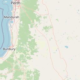
Korung National Park is best known for its position at the intersection of two major southwest Australian bioregions, representing the transition between the Swan Coastal Plain and the jarrah forest. The park provides accessible natural experiences for Perth residents, with walking trails traversing diverse landscapes from woodland areas to forest environments. The presence of the Munda Biddi Trail through the park makes it a notable destination for cycling enthusiasts, while its proximity to the Perth metropolitan area establishes it as an important green space for regional environmental education and nature-based recreation.

Korung National Park history and protected-area timeline

Korung National Park was established in 2004 as Pickering Brook National Park, representing a formalisation of protection for natural areas in the Perth hills region that had previously existed in other designations or lacked formal conservation status. The decision to rename the park to Korung in 2008 marked a significant shift toward incorporating indigenous perspectives into Western Australia's protected area naming conventions. The name Korung reflects an effort to use Noongar language and acknowledge the cultural heritage of the traditional owners of the land. The park's creation and subsequent enhancement responded to growing recognition of the importance of preserving green spaces within and around the Perth metropolitan region, where development pressure continues to transform natural landscapes. The administrative responsibility for the park rests with the Department of Biodiversity, Conservation and Attractions, which manages it as part of the broader network of Western Australian national parks.

Korung National Park landscape and geographic character

The landscape of Korung National Park is defined by its position on the Darling Scarp, a steep geological escarpment that rises sharply from the Swan Coastal Plain. The park spans the transition between these two major landscape units, with western portions occupying the gently undulating terrain of the coastal plain before ascending the steeper slopes of the scarp itself. The eastern areas of the park lie within the dissected plateau that characterises the jarrah forest region, featuring laterite soils and a more subdued relief compared to the dramatic scarps found in other parts of the southwest. Vegetation patterns across the park reflect this topographic variation, with different plant communities occupying the various landscape positions. The park's scenic qualities derive from the views available across the coastal plain toward the Perth skyline, as well as the characteristic woodland and forest environments that dominate the reserve.

Korung National Park ecosystems, habitats, and plant life

The ecological character of Korung National Park reflects its position spanning two major bioregions of southwest Western Australia. The western portions of the park fall within the Swan Coastal Plain bioregion, which supports a range of vegetation types including woodland and heath communities adapted to the sandy soils and Mediterranean climate of the coast. East of the Darling Scarp, the park enters the Jarrah Forest bioregion, characterised by the dominant presence of jarrah (Eucalyptus marginata), a cornerstone species of southwest Australian forests. This bioregion is renowned for its high biodiversity and the distinctive tall woodland and forest ecosystems that develop on the laterite-rich soils of the region. The park's location within these two bioregions means it protects transitional habitat types that may support species characteristic of both the coastal plain and the forest interior, contributing to the ecological diversity of the protected area network in the Perth region.

Korung National Park wildlife and species highlights

The wildlife of Korung National Park reflects the diversity of habitats present within its boundaries, spanning the Swan Coastal Plain and jarrah forest bioregions. The jarrah forest environment supports a range of bird species typical of southwest Australian woodlands, including honeyeaters, cockatoos and parrots that utilise the nectar-rich flowering of native plants throughout the year. Mammals likely present include various marsupial species adapted to forest and woodland habitats, though specific documentation of fauna inventories for the park is limited in available sources. The transitional nature of the landscape, moving from coastal plain to forest, may support ecological diversity as species from both environments utilise the different habitat types present within the reserve.

Korung National Park conservation status and protection priorities

Korung National Park contributes to conservation outcomes in the Perth metropolitan region by protecting representative samples of Swan Coastal Plain and jarrah forest ecosystems within a largely cleared and modified landscape. The park forms part of a network of protected areas that collectively maintain biodiversity in the region surrounding Perth, where urban expansion has dramatically reduced native vegetation coverage. The connectivity provided by the park's proximity to Midgegooroo National Park supports broader landscape-scale conservation objectives, allowing for wildlife movement and ecological processes to continue across a larger contiguous area. The establishment of the reserve in 2004 and its subsequent renaming to incorporate indigenous heritage reflects evolving approaches to conservation management that acknowledge both ecological and cultural values.

Korung National Park cultural meaning and human context

The renaming of Korung National Park from its former designation as Pickering Brook National Park in 2008 reflects growing recognition of indigenous heritage in Western Australia's protected area management. The name Korung derives from Noongar language, representing an effort to acknowledge the traditional owners and their connection to the land. The Darling Scarp region holds cultural significance for Noongar people, who have inhabited southwest Western Australia for many thousands of years. The integration of Noongar language into place naming represents one dimension of broader efforts to incorporate indigenous knowledge and values into contemporary conservation practice.

Top sights and standout views in Korung National Park

Korung National Park offers visitors accessible nature experiences within the Perth metropolitan region, with walking trails providing opportunities to explore the transition between coastal plain and jarrah forest environments. The park's position on the Darling Scarp provides scenic views across the Swan Coastal Plain toward Perth, while the Munda Biddi Trail passing through the reserve connects it to a major long-distance cycling route spanning over 1000 kilometres through southwest Western Australia. The park's dual bioregion character makes it representative of the ecological diversity found in the Perth hills region, while its proximity to Armadale and Kalamunda makes it a convenient destination for day visitors seeking wilderness experiences without travelling far from the city.

Best time to visit Korung National Park

The optimal time to visit Korung National Park coincides with the cooler months of Western Australia's Mediterranean climate, typically from April through October. During this period, mild daytime temperatures make walking and cycling more comfortable, and the winter rainfall season promotes lush vegetation and flowing wildflowers across the park. Spring months, particularly September and October, often bring peak wildflower displays as the jarrah forest and woodland habitats erupt with colour. Summer months from November to March can be hot and dry, with elevated fire risk potentially affecting access and trail conditions. Visitors planning activities should check current conditions and be aware that summer heat may significantly limit comfortable exploration of the park's trails.

Park location guide

Geography guide, regional context, and park location map for Korung National Park

Korung National Park park geography, regions, and map view in Australia
Understand where Korung National Park sits in Australia through a broader geographic reading of the surrounding landscape, nearby location context, and its mapped position within the national park landscape.

How Korung National Park fits into Australia

Australia is a constitutional monarchy and federal parliamentary democracy comprising six states and ten territories. With a population of nearly 28 million, it is one of the world's most urbanised countries, with most people concentrated on the eastern seaboard. The country has a high Human Development Index and is known for its cultural diversity, ancient Aboriginal heritage, and unique wildlife.

Wider geography shaping Korung National Park in Australia

Australia occupies the entire Australian continent, the island of Tasmania, and numerous smaller islands. It is the world's flattest and driest inhabited continent, featuring vast deserts in the interior (the Outback), tropical rainforests along the eastern coast, and a coastline bordering the Indian and Pacific Oceans.

Map view of Korung National Park

Use this park location map to pinpoint Korung National Park in Australia, understand its exact geographic position, and read its mapped placement within the surrounding landscape more clearly.

Pigeon | © OpenStreetMap contributors

Location context for Korung National Park

Western Australia
Park atlas

Compare nearby national parks and protected landscapes across the Perth Hills region and the broader geographic spread of Western Australia.

Discover More Protected Areas Near Korung National Park: Explore Western Australia's Jarrah Forests and Darling Scarp Landscapes
Explore other national parks and protected areas within Western Australia, focusing on the unique geographical transition zones and the contiguous conservation landscapes found near Korung National Park. Trace the regional distribution of diverse protected habitats across the Darling Scarp and Swan Coastal Plain, enabling a comprehensive atlas-style comparison of distinct park entities.
National parkPerth metropolitan region

Midgegooroo National Park: Jarrah Forest Protected Landscape and Regional Geography

Explore its mapped boundaries and terrain near Perth.

Midgegooroo National Park offers a distinct protected landscape characterized by its expansive jarrah forest terrain within the Perth metropolitan region. This national park provides valuable context for understanding regional geography, mapped natural features, and the distribution of protected lands. Explore the park's unique topography and conservation boundaries, vital for comprehensive atlas-based geographic discovery.

Area
24.92 km²
Established
2004
IUCN
II
National parkWestern Australia

Kalamunda National Park: Explore Darling Scarp Woodland & Western Australia's Natural Terrain

A protected national park with distinct mapped landscape features.

Kalamunda National Park is an essential protected area located on the western slopes of the Darling Scarp, offering a clear representation of southwestern Australia's characteristic eucalypt woodland ecosystems. Its geography is defined by the escarpment's terrain, supporting tall marri, jarrah, and wandoo forests with a diverse understorey. As a national park, it provides critical habitat and contributes to the regional landscape context within Western Australia, making it a valuable point for atlas-driven discovery of protected natural areas.

Area
3.75 km²
Established
1964
IUCN
II
National parkWestern Australia

Beelu National Park: Exploring Western Australia's Protected Jarrah-Marri Forest Landscape

Mapped Geographic Context & Natural Terrain Discovery

Beelu National Park, situated in Western Australia's Darling Range, offers an immersive experience within old-growth jarrah-marri forests. This protected area provides a vital glimpse into the region's natural landscapes, characterized by rolling hills and the Helena River valley. Users can explore the park's geographic setting, its mapped boundaries, and the unique ecological context it preserves. It stands as a significant natural reserve contributing to the understanding of Western Australia's conservation efforts and diverse terrain.

Area
46.17 km²
Established
1995
IUCN
II
National parkWestern Australia

Serpentine National Park: Waterfall & Wildflower Protected Landscape in Western Australia

Mapped geography, waterfall terrain, and spring bloom discovery.

Serpentine National Park is a protected national park located in Western Australia, approximately 55 kilometers southeast of Perth. It is celebrated for its prominent Serpentine Falls, a multi-tiered cascade that forms a popular natural pool, and its stunning spring wildflower season. The park showcases the undulating terrain of the Darling Scarp, featuring jarrah and marri woodlands. This park offers a distinct opportunity for atlas-based exploration of protected landscapes, with a focus on its unique waterfall features and vibrant botanical displays.

Area
43.87 km²
Established
1957
IUCN
II
National parkWestern Australia

Yanchep National Park: Explore Its Unique Limestone Caves and Protected Bushland Geography

Discover the subterranean formations and coastal plain landscapes.

Yanchep National Park offers a singular opportunity for atlas-driven exploration of Western Australia's natural and cultural heritage. Situated on the Swan Coastal Plain, this national park is celebrated for its extensive network of limestone caves, including the notable Crystal Cave, providing a rare glimpse into subterranean geological processes. Beyond its underground wonders, the park encompasses diverse native bushland, supporting iconic koala colonies and offering insights into the region's ecological distinctiveness. Its deep Nyoongar heritage further enriches the understanding of this mapped protected landscape.

Area
28.76 km²
Established
1957
IUCN
II
National parkWestern Australia

Wellington National Park: Protected Jarrah Forest & Collie River Landscape

Explore the mapped boundaries and regional geography.

Wellington National Park offers a deep dive into Western Australia's protected landscapes, characterized by extensive old-growth jarrah forests and the scenic Collie River valley. This national park provides a vital study of the region's unique geography, mapped terrain, and ecological significance within the Yilgarn craton. Understand the park's protected area identity and its place in the wider natural context of Western Australia through its detailed landscape features.

Area
170 km²
Established
2000
IUCN
II
National parkSouth West

Yelverton National Park: South West Australia's Biodiversity Conservation Area

Mapped protected lands and regional landscape context.

Yelverton National Park offers a focused look at a protected area in Western Australia's South West, distinguished by its commitment to rare species and varied vegetation. Established from former timber reserve lands, it serves as a crucial habitat refuge. The park's geography exemplifies the ecological richness of the South-West Australian forest region, providing valuable context for understanding protected landscape distribution and conservation efforts within the mapped terrain.

Area
7.29 km²
Established
2004
IUCN
II
National parkWestern Australia

Wooditjup National Park: Protected Forest Landscape and Regional Geographic Context

Explore mapped boundaries of this Western Australia national park.

Wooditjup National Park stands as a testament to Western Australia's unique forest ecosystems, specifically within the Jarrah Forest bioregion. This protected area offers a distinct natural landscape contrasting with the nearby coastal attractions of Margaret River. Delve into the park's mapped geography, understand its role as a national park, and appreciate its position within the broader South West Australian landscape and its traditional Wardandi Country heritage.

Area
38.92 km²
Established
2004
IUCN
II

Common questions about visiting, size, designation, and location context for Korung National Park

Korung National Park FAQs for park facts, access, geography, and protected area context
Find quick answers about Korung National Park, including protected-area facts, park geography, trail and visitor context, and how the park fits into its surrounding country and regional landscape.
MoriAtlas Explorer

Continue Your Protected Areas Search Across the Global Atlas

Deepen your exploration by continuing the structured search for national parks and protected areas worldwide. Utilize the comprehensive filtering capabilities to compare different conservation landscapes and refine your understanding of global park geography. Discover more about the distribution and characteristics of protected natural areas.

Global natural geography