Mori Atlas logo
National parkMapungubwe National Park

Discover the unique Iron Age heritage and savanna ecosystems at this Limpopo protected area.

Mapungubwe National Park: Protected Landscape Atlas and Geographic Context

Mapungubwe National Park represents a pivotal protected area in South Africa's Limpopo Province, recognized for its profound archaeological significance and expansive savanna ecosystems. Situated at the confluence of Botswana, South Africa, and Zimbabwe, this national park offers a unique window into the Iron Age Kingdom of Mapungubwe and its extensive trade networks. Users can explore its mapped boundaries, understand its position within regional geography, and appreciate the diverse natural landscapes that define this UNESCO World Heritage Site and its surrounding Transfrontier Conservation Area.

World Heritage SiteIron Age ArchaeologyTransfrontier ConservationSavanna EcosystemMopane WoodlandRiparian Forest
Illustration of savanna landscape featuring large baobab tree, smaller baobabs, rocky outcrops, and grassy terrain under a clear sky

Mapungubwe National Park

National park

Park overview

Structured park overview, official facts, and landscape profile for Mapungubwe National Park

Mapungubwe National Park park facts, protected area profile, and essential visitor context
Review the core facts for Mapungubwe National Park, including designation, size, terrain, visitor scale, habitats, and operating context in one park-focused overview.

About Mapungubwe National Park

Mapungubwe National Park represents a remarkable fusion of archaeological significance and ecological diversity in northern South Africa. The park forms the center of the UNESCO Mapungubwe Cultural Landscape, a World Heritage Site that encompasses the broader region around Mapungubwe Hill where evidence of a sophisticated Iron Age civilization was uncovered in the early 20th century. Archaeologists working at the site discovered the famous Golden Rhinoceros figurine, gold jewellery, and other artefacts that revealed the wealth and artistic achievements of the Kingdom of Mapungubwe, which flourished between approximately 1250 and 1350 CE as a center of trade in gold, ivory, and other commodities. Today, visitors can explore the archaeological site and the award-winning Museum and Interpretative Centre, which houses many of the artefacts and provides context for understanding this ancient civilization. The park is managed by South African National Parks and forms part of the Greater Mapungubwe Transfrontier Conservation Area, a collaborative initiative linking protected areas across South Africa, Botswana, and Zimbabwe to enable large-scale conservation and migratory species movement.

Quick facts and research context for Mapungubwe National Park

Mapungubwe National Park is located in the Limpopo Province of northern South Africa, bordering Botswana and Zimbabwe as part of a transfrontier conservation area. The park was established in 1998 as Vhembe-Dongola National Park and renamed to Mapungubwe National Park upon its official opening on Heritage Day, September 24, 2004. It protects the cultural landscape surrounding Mapungubwe Hill, an Iron Age site that was the capital of the Kingdom of Mapungubwe between the 13th and 14th centuries. The park contains at least 24 Acacia species and 8 Commiphora species, with notable fever trees, ana trees, leadwoods, and ancient baobabs along the Limpopo River. Over 380 bird species have been recorded, alongside diverse mammals including elephants, rhinos, lions, leopards, cheetahs, and wild dogs.

Park context

Deeper park guide and search-rich context for Mapungubwe National Park

Mapungubwe National Park history, landscape, wildlife, and travel context
Explore Mapungubwe National Park through its history, landscape character, ecosystems, wildlife, conservation priorities, cultural context, and seasonal travel timing in a structured park guide built for atlas discovery and search intent.

Why Mapungubwe National Park stands out

Mapungubwe is best known for its unique dual identity as both a world-renowned archaeological site and a thriving wilderness area. The discovery of the Golden Rhinoceros of Mapungubwe and extensive gold artefacts on Mapungubwe Hill revealed a sophisticated Iron Age civilization that traded gold and ivory across southern Africa between the 13th and 14th centuries. The park's UNESCO World Heritage status recognizes this extraordinary cultural landscape alongside its natural values. The landscape is characterized by dramatic baobab-studded savanna, the lush riparian fringe of the Limpopo River with its fever tree forest, and panoramic views from Mapungubwe Hill overlooking the confluence of three countries. The park also supports significant populations of the endangered African wild dog and serves as a Lion Conservation Unit.

Stone dome-shaped buildings with arched structures surrounded by green vegetation under a clear blue sky
Stone dome structures of Mapungubwe National Park's visitor center

Mapungubwe National Park history and protected-area timeline

The history of Mapungubwe spans geological timeframes extending back 210 million years when dinosaurs including Plateosauravus inhabited the region, through millennia of human occupation to its modern establishment as a protected area. The contemporary conservation story began in the 1920s when botanist Illtyd Buller Pole-Evans initiated agricultural research in the area, leading to the creation of the Botanical Survey Advisory Committee. At the request of Prime Minister Jan Smuts, the government set aside nine farms as the Dongola Botanical Reserve in 1918, later expanded under Pole-Evans to include 27 farms by the early 1940s, encompassing Greefswald where Mapungubwe Hill is located. In 1944, Minister of Lands Andrew Conroy proposed the Dongola Wildlife Sanctuary covering 124 farms, sparking what became known as the "Battle of Dongola," one of the longest parliamentary debates in South African history. Opponents argued against alienating agricultural land while supporters emphasized conservation needs and archaeological preservation. The reduced sanctuary was declared but abolished in 1949 after the National Party won power. In 1967, the Vhembe Nature Reserve was established on three farms. The modern park emerged after De Beers, which had established the Venetia Limpopo Nature Reserve adjacent to Greefswald, called for national park status in 1993. The Vhembe-Dongola National Park was proclaimed in 1998 and renamed Mapungubwe National Park in 2004, opening on Heritage Day to mark its cultural significance.

Mapungubwe National Park landscape and geographic character

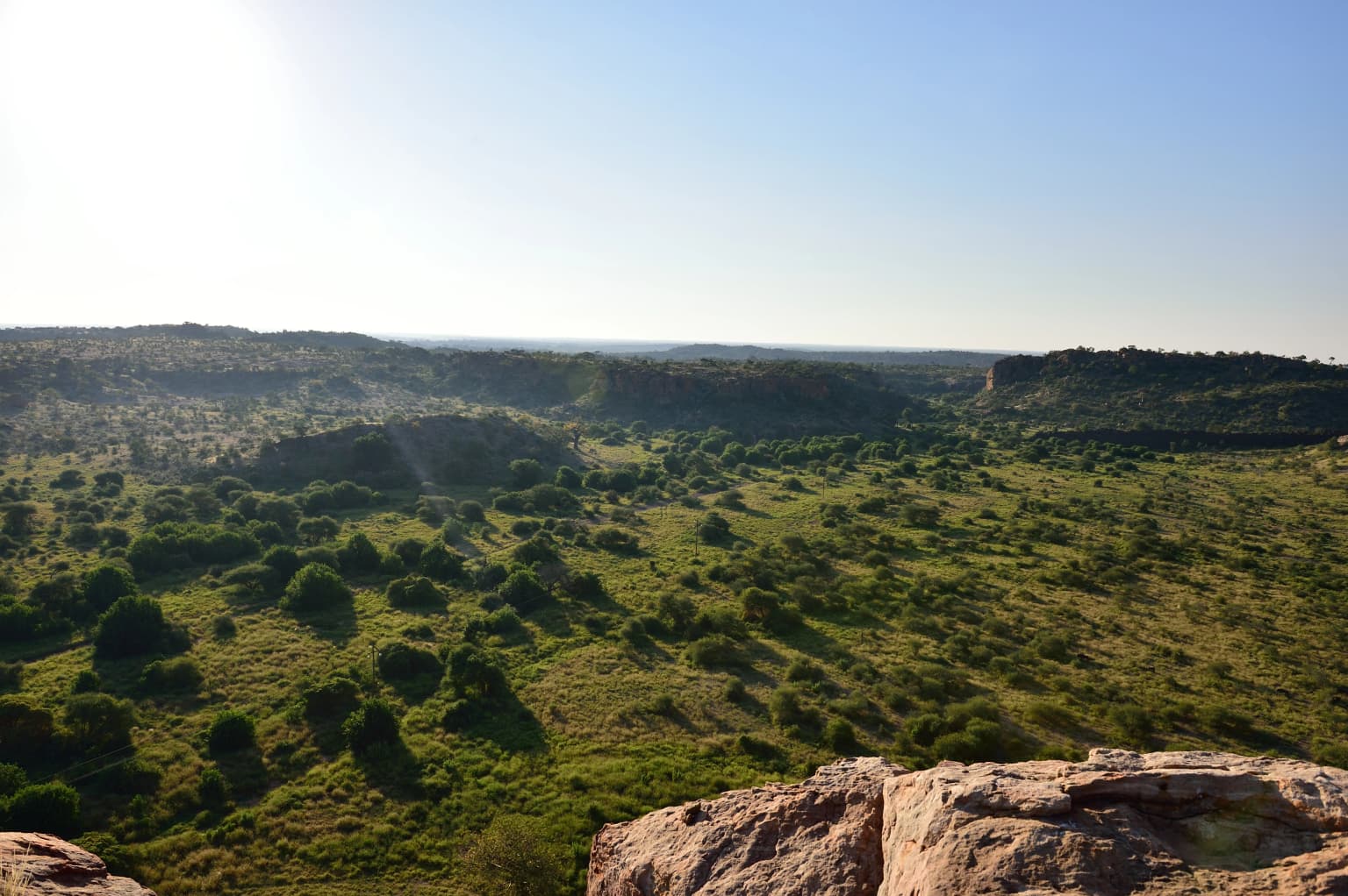
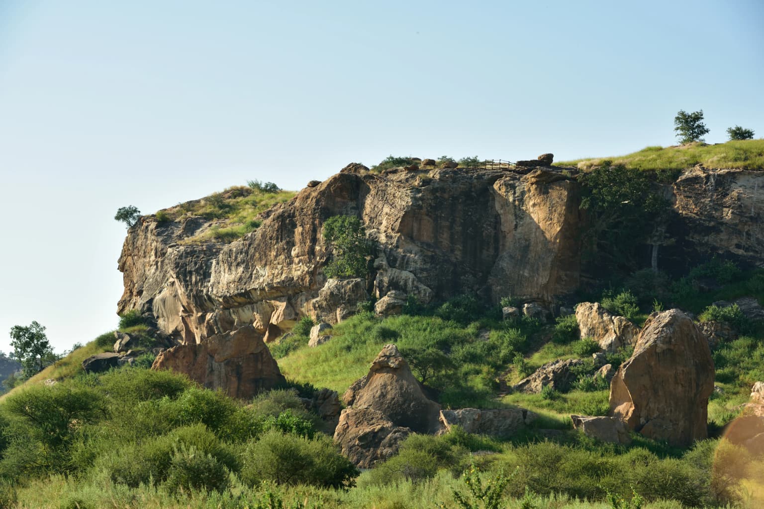
The physical landscape of Mapungubwe National Park is defined by its position along the Limpopo River floodplain and the surrounding savanna plains dominated by mopane woodland. The most striking feature of the park is the riparian forest along the Limpopo, a dense vegetation community with a closed canopy that thrives in the rich alluvial deposits, featuring fever trees, ana trees, leadwoods, fig trees, and various acacia species. This riverine corridor supports trees of exceptional size, including massive nyala berry and ana trees. The park contains several very large baobab trees, with one specimen measuring 31 meters in circumference. Beyond the river, the landscape transitions to typical mopane woodland, a short fairly dense growth of shrubby mopane trees associated with other trees, shrubs, and tufted grasses. Rocky outcrops and hills, including the significant Mapungubwe Hill itself, punctuate the terrain. The park sits at relatively low elevation in the far north of South Africa, forming a natural gateway where three countries meet at the confluence of rivers and ecological zones.

Large gray African Elephant bull with long tusks standing in grassy terrain with sparse bushes and rocky background
African Elephant bull in Mapungubwe National Park

Mapungubwe National Park ecosystems, habitats, and plant life

The ecological diversity of Mapungubwe results from the variety of habitat types present within the park boundaries and its position at the transition between southern and central African biomes. The vegetation includes at least 24 Acacia species and 8 Commiphora species, with mopane woodland forming the dominant plant community across the savanna plains. The riparian fringe along the Limpopo River represents the most significant conservation area, preserving dense forest that has been largely cleared for cultivation elsewhere along the river. This riverine ecosystem supports species typical of watercourses in the region, while the surrounding woodlands host distinct communities of thorny acacias and drought-resistant species. The park's position at the confluence of three countries facilitates the movement of migratory species across the broader transfrontier conservation area, though the integrity of these ecological connections faces challenges from surrounding development pressures.

Wide landscape of Limpopo River valley with green savanna vegetation and rocky outcrops under clear blue sky
View of the Limpopo River valley in Mapungubwe National Park

Mapungubwe National Park wildlife and species highlights

Mapungubwe National Park supports remarkable wildlife diversity across multiple animal groups, with 387 bird species recorded within its boundaries. The bird community includes notable species such as Verreaux's eagle, Pel's fishing owl, grey crowned crane, ground hornbill, and Kori bustard, with the Limpopo floodplain particularly important for storks, herons, waders, and waterfowl. Mammalian species are abundant and include flagship species such as African bush elephant, southern white rhinoceros, and significant populations of large predators. Mapungubwe is recognized as a Lion Conservation Unit and also supports African leopard, South African cheetah, African wild dog, spotted hyena, and brown hyena. The park contains diverse antelope species including common eland, blue wildebeest, kudu, Burchell's zebra, waterbuck, impala, klipspringer, duiker, steenbok, red hartebeest, and oryx. Smaller mammals include aardvark, African civet, caracal, and at least 17 bat species. Reptile diversity includes Nile crocodile along the river, monitor lizards, pythons, cobras, black mambas, and an estimated 32 snake species.

Golden rhinoceros sculpture on a clear acrylic base
Golden rhinoceros artifact displayed in a museum setting

Mapungubwe National Park conservation status and protection priorities

Mapungubwe's conservation significance is recognized internationally through its UNESCO World Heritage inscription and its role within the Greater Mapungubwe Transfrontier Conservation Area, which coordinates protection efforts across South Africa, Botswana, and Zimbabwe. The park's UNESCO status acknowledges both the cultural landscape of Mapungubwe Hill and the outstanding natural values of the region. The park serves as a critical Lion Conservation Unit, linking with South Luangwa National Park in Zambia to support viable populations of this apex predator. However, the park faces significant conservation threats from planned mining activities in the surrounding area. An open-cast coal mine and power plant are proposed for the buffer zone adjacent to the park, which would impact both the natural and cultural values that justified World Heritage status. The water requirements for mining operations pose additional threats to the Limpopo River ecosystem upon which much of the park's biodiversity depends.

Mapungubwe National Park cultural meaning and human context

The cultural significance of Mapungubwe centers on the Iron Age kingdom that flourished on the hill between approximately 1250 and 1350 CE. The Kingdom of Mapungubwe was a sophisticated trading civilization that controlled commerce in gold, ivory, and other commodities across southern Africa, with connections extending to Indian Ocean trade routes. The archaeological excavations on Mapungubwe Hill revealed not only the Golden Rhinoceros but also gold beads, jewellery, ceramics, and other artefacts that demonstrate the artistic and metallurgical capabilities of this civilization. The site represents one of the most important archaeological discoveries in southern Africa and provides insight into the complexity of pre-colonial African societies. The park's opening on Heritage Day, a national holiday in South Africa, reflects the importance placed on this cultural legacy. The Museum and Interpretative Centre, which won World Building of the Year in 2009, provides modern interpretation of this ancient heritage.

Nile Monitor lizard with blue tongue extending near muddy water's edge on dry ground
Nile Monitor lizard near a water source in Mapungubwe National Park

Top sights and standout views in Mapungubwe National Park

The Mapungubwe experience combines archaeological exploration with wilderness immersion at a unique geographical crossroads. Mapungubwe Hill offers panoramic views across the three-country confluence and provides access to the archaeological site where the Golden Rhinoceros was discovered. The Museum and Interpretative Centre showcases artefacts from the Iron Age kingdom and explains both the archaeological and ecological significance of the landscape. The riparian forest along the Limpopo River features iconic fever trees and massive baobabs, with elevated boardwalks allowing visitors to walk through the canopy. Wildlife viewing opportunities include encounters with elephants, rhinos, and predators including lions, leopards, and African wild dogs, while the bird list of nearly 400 species attracts ornithologists. The park's position at the meeting point of three nations makes it a distinctive destination for understanding both natural and cultural heritage.

Rocky cliffs with patches of green vegetation overlooking the Limpopo River under a clear blue sky
Limpopo River flowing through rocky cliffs in Mapungubwe National Park

Best time to visit Mapungubwe National Park

The optimal time to visit Mapungubwe depends on what visitors hope to experience, with the dry winter months from May to September offering the best wildlife viewing as animals concentrate around water sources and vegetation is less dense. The cooler temperatures during this period make outdoor activities more comfortable, though nights can be cold. The summer months from October to April bring higher temperatures and the possibility of rain, which transforms the landscape with new growth and creates greener scenery. Birdwatching is excellent year-round but particularly rewarding in the wet season when migratory species are present. The park can be visited throughout the year, though summer temperatures in this northern region can be extreme and visitors should plan accordingly. The Museum and Interpretative Centre provides welcome respite from the heat and offers comprehensive context for understanding both the archaeological significance and natural values of the park.

Park location guide

Geography guide, regional context, and park location map for Mapungubwe National Park

Mapungubwe National Park park geography, regions, and map view in South Africa
Understand where Mapungubwe National Park sits in South Africa through a broader geographic reading of the surrounding landscape, nearby location context, and its mapped position within the national park landscape.

How Mapungubwe National Park fits into South Africa

South Africa is the southernmost country in Africa, spanning 1.22 million km² with a population of over 63 million. The country operates with three capital cities, Pretoria (executive), Cape Town (legislative), and Bloemfontein (judicial), and is renowned for its biodiversity, national parks, and multicultural society.

Wider geography shaping Mapungubwe National Park in South Africa

South Africa occupies the southernmost region of Africa, with coastline along both the Atlantic Ocean to the west and the Indian Ocean to the east. The interior features elevated plateaus including the Highveld, with the Drakensberg escarpment marking the eastern highlands. The country shares borders with Namibia, Botswana, Zimbabwe, Mozambique, Eswatini, and Lesotho.

Map view of Mapungubwe National Park

Use this park location map to pinpoint Mapungubwe National Park in South Africa, understand its exact geographic position, and read its mapped placement within the surrounding landscape more clearly.

Pigeon | © OpenStreetMap contributors

Location context for Mapungubwe National Park

Limpopo

Visual Guide to Mapungubwe's Iconic Savanna, Riparian Forests, and Protected-Area Terrain

Mapungubwe National Park Photos: Explore Diverse Landscapes and Wilderness Scenery
Explore a visual atlas of Mapungubwe National Park, showcasing its distinctive savanna ecosystems and the lush riparian forests along the Limpopo River. These images offer key insights into the park's unique cultural heritage, diverse habitats, and characteristic protected environment at the three-country confluence.

Stone dome-shaped buildings with arched structures surrounded by green vegetation under a clear blue sky

A large baobab tree with a thick trunk and spreading branches in a grassy field under a clear sky

Large gray African Elephant bull with long tusks standing in grassy terrain with sparse bushes and rocky background

Wide landscape of Limpopo River valley with green savanna vegetation and rocky outcrops under clear blue sky

Golden rhinoceros sculpture on a clear acrylic base

Rocky hillside with scattered acacia trees and clear blue sky in Mapungubwe National Park

Nile Monitor lizard with blue tongue extending near muddy water's edge on dry ground

Rocky cliffs with patches of green vegetation overlooking the Limpopo River under a clear blue sky

Close-up of a stone game board with multiple circular indentations carved into a reddish-brown rock surface

Wooden boardwalk with railings surrounded by dense green trees and vegetation

A grassy field with scattered rock formations and a dirt trail leading toward hills under a clear sky

Klipspringer antelope standing on rocky outcrop with light sky background

Rock face with red-painted giraffe artwork, part of the Mapungubwe Cultural Landscape

Park atlas

Trace the geographic spread of protected areas and conservation landscapes near Mapungubwe National Park's confluence.

Discover Nearby National Parks and Protected Areas Surrounding Mapungubwe National Park
Explore an expansive atlas of national parks and protected areas situated within the broader Limpopo region, tracing conservation landscapes across the tri-border confluence of South Africa, Botswana, and Zimbabwe. Compare diverse savanna ecosystems, significant riparian forests, and cultural heritage sites to deepen your understanding of the regional protected-area network.
Protected areaSouth Africa

Greater Mapungubwe Transfrontier Conservation Area: A Transboundary Protected Landscape in South Africa

Mapped savanna ecosystems and rich cultural heritage at the Limpopo River confluence.

The Greater Mapungubwe Transfrontier Conservation Area, situated in South Africa, stands as a remarkable example of collaborative conservation across national borders. This protected area protects diverse savanna landscapes, particularly around the confluence of the Shashe and Limpopo Rivers, and holds immense cultural value as home to the Mapungubwe Cultural Landscape, a UNESCO World Heritage Site. By examining its mapped geography and protected area status, users gain insight into the ecological corridors vital for wildlife and the ancient archaeological heritage preserved within this significant transfrontier initiative.

Area
4,872 km²
Established
2009
IUCN
VI
Relief
Upland
National parkMatobo District

Matobo National Park: Detailed Protected Area and Landscape Geography in Matobo District

Explore its mapped boundaries and regional context.

Delve into the protected landscape of Matobo National Park, a significant national park situated in Matobo District, Zimbabwe. This entry focuses on providing a structured atlas view, highlighting the park's mapped boundaries and its integration within the regional geography. Understand Matobo National Park as a distinct protected area entity, perfect for users seeking detailed geographic context and landscape insights for map-based discovery and conservation analysis.

Area
424 km²
Established
1926
IUCN
II
Relief
Mountain
National parkMasvingo Province

Gonarezhou National Park: National Park Protected Landscape in Masvingo Province

Explore mapped boundaries and regional geography

Gonarezhou National Park represents a significant protected area within the geography of Masvingo Province, Zimbabwe. This page details its specific mapped boundaries and landscape context, offering a focused view for atlas-based exploration. Understand the park's natural terrain and its positioning within the regional protected lands for comprehensive geographic discovery.

Area
5,053 km²
Established
1975
IUCN
II
Relief
Mixed relief
National parkLimpopo Province

Marakele National Park: National Park Protected Landscape and Geographic Context

Explore its Limpopo Province regional setting and mapped boundaries.

Marakele National Park represents a vital protected national park within the diverse geography of Limpopo Province, South Africa. This entry provides detailed atlas-style information on its protected landscape, focusing on mapped geographic boundaries and its context within the regional natural terrain. It serves as a key resource for understanding the park's specific role as a conservation area and its place within the broader atlas of South African protected lands.

Area
670 km²
Established
1994
Relief
Mountain
Climate
Subtropical
National parkSouth Africa

Kruger National Park: South Africa's Iconic National Park for Geographic Discovery

Explore savanna landscapes and mapped protected area boundaries.

Kruger National Park serves as a paramount example of a protected landscape, offering a rich tapestry of savanna ecosystems and varied terrain across South Africa's Lowveld. This canonical entry details its vast geographic scope, approximately 19,623 square kilometres, and its status as the nation's first national park. Understand the park's environmental context, from the Lebombo Mountains to the Limpopo River, and its integral role within larger transfrontier conservation initiatives, providing critical insight for atlas-based geographic exploration.

Area
19,623 km²
Established
1926
IUCN
II
Visitors
1.7M annual
National parkGaza Province

Banhine National Park National Park: Mapped Boundaries and Gaza Province Geographic Context

Discover the protected landscape identity of this national park.

Delve into the specifics of Banhine National Park, a designated national park situated within Gaza Province. This entry provides essential geographic details, focusing on its mapped protected area, its status as a national park, and how it fits within the broader regional geography of southern Mozambique. Understand the park's landform context and its atlas-relevant attributes for structured discovery.

Area
7,250 km²
Established
1973
IUCN
II
Relief
Lowland
National parkMozambique

Zinave National Park: A Mozambique National Park with Diverse Woodland and Savanna Landscapes

Explore its mapped terrain, riverine forests, and savanna ecosystems.

Zinave National Park in Mozambique is a significant protected area spanning 4,000 square kilometers. Its landscape comprises a rich variety of ecosystems, including miombo woodlands, mopane-dominated areas, acacia savannas, and distinct riverine forests along the Save River. This national park is strategically positioned within the Greater Limpopo Transfrontier Park, highlighting its importance for regional wildlife corridors and conservation geography. The terrain offers a unique insight into the transitional ecological zones of southern Africa, showcasing diverse natural habitats and mapping potential for its protected boundaries.

Area
4,000 km²
Established
1973
IUCN
II
Relief
Lowland
National parkManica Province

Chimanimani National Park: Map of Mozambique's Highest Mountain Landscape

Explore protected highland terrain and transfrontier conservation geography.

Chimanimani National Park stands as a vital protected area in Mozambique's Manica Province, celebrated for its rugged mountain landscape and the presence of Monte Binga, the country's highest point. As the Mozambican portion of the Chimanimani Transfrontier Park, it offers critical insights into cross-border conservation efforts and the preservation of unique montane ecosystems. Discover the park's geographic context, its elevation extremes, and the significance of its protected boundaries within the regional atlas.

Area
656 km²
Established
2020
IUCN
II
Relief
Mountain

Common questions about visiting, size, designation, and location context for Mapungubwe National Park

Mapungubwe National Park FAQs for park facts, access, geography, and protected area context
Find quick answers about Mapungubwe National Park, including protected-area facts, park geography, trail and visitor context, and how the park fits into its surrounding country and regional landscape.
MoriAtlas Explorer

Continue Your Protected Areas Search Across the Global Atlas

Deepen your exploration by continuing the structured search for national parks and protected areas worldwide. Utilize the comprehensive filtering capabilities to compare different conservation landscapes and refine your understanding of global park geography. Discover more about the distribution and characteristics of protected natural areas.

Global natural geography