Mori Atlas logo
National parkQuirimbas National Park

Explore the mapped boundaries and diverse ecosystems of this coastal national park.

Quirimbas National Park: Protected Marine and Terrestrial Landscapes of Cabo Delgado Province

Quirimbas National Park represents a critical protected landscape in Mozambique's Cabo Delgado Province, safeguarding a unique mosaic of marine and terrestrial environments. This national park encompasses eleven southern Quirimbas Islands and a significant strip of adjacent mainland coastline, characterized by dramatic inselbergs, extensive mangrove systems, and vibrant coral reefs. Established to preserve its rich biodiversity and distinctive geography, the park offers an unparalleled opportunity for atlas-driven discovery of coastal wilderness, marine conservation, and unique island ecosystems.

coastal national parkisland archipelagocoral reef protectionmarine conservationmangrove ecosystemsEast Africa wildlife

Quirimbas National Park

National park

Park overview

Structured park overview, official facts, and landscape profile for Quirimbas National Park

Quirimbas National Park park facts, protected area profile, and essential visitor context
Review the core facts for Quirimbas National Park, including designation, size, terrain, visitor scale, habitats, and operating context in one park-focused overview.

About Quirimbas National Park

Quirimbas National Park represents a unique conservation model that protects both archipelago and mainland ecosystems within a single protected area. The park stretches for 110 kilometres along Mozambique's northeastern coast, incorporating eleven of the southernmost islands in the Quirimbas chain alongside a substantial coastal mainland zone. The terrestrial portion includes the Taratibua region, characterized by isolated inselberg mountains that rise dramatically from the surrounding coastal plain, creating a landscape of significant visual and geological interest. The islands themselves vary considerably in size and character, from larger inhabited islands like Ibo and Matemo to smaller uninhabited islets that serve as critical nesting sites for seabirds and marine turtles. The park's marine component is particularly significant, protecting extensive coral reef systems, sea grass beds, and mangrove forests that serve as nursery habitats for numerous fish species and other marine organisms. The combination of protected marine and terrestrial zones makes Quirimbas one of Mozambique's most ecologically diverse protected areas, supporting species ranging from large mammals on the mainland to critically important marine invertebrates in the reef systems.

Quick facts and research context for Quirimbas National Park

Quirimbas National Park is located in Cabo Delgado Province, northeastern Mozambique, spanning 110 kilometres along the coast and including the southernmost eleven islands of the Quirimbas archipelago. The park protects 913,000 hectares of coastal forest, mangroves, and coral reefs. The climate is tropical with a rainy season from December to April and a drier, cooler season from May to September. Daytime temperatures range from 25 to 35 degrees Celsius, while water temperatures stay between 24 and 27 degrees Celsius. Key islands include Ibo, Matemo, Quirimba, Quisiva, Quilálea, and Rolas, each offering distinct ecosystems and cultural heritage.

Park context

Deeper park guide and search-rich context for Quirimbas National Park

Quirimbas National Park history, landscape, wildlife, and travel context
Explore Quirimbas National Park through its history, landscape character, ecosystems, wildlife, conservation priorities, cultural context, and seasonal travel timing in a structured park guide built for atlas discovery and search intent.

Why Quirimbas National Park stands out

Quirimbas National Park is best known for its exceptional combination of marine and terrestrial protected landscapes. The park encompasses one of East Africa's most extensive coastal forest and mangrove systems, alongside thriving coral reef ecosystems that support more than 375 identified fish species. The islands are renowned for their historical significance as former Swahili trading post locations, particularly Ibo Island with its colonial-era architecture. The mainland region features dramatic inselberg formations rising from the coastal plain, creating a distinctive geological landscape. Marine life includes threatened species such as pipefish and seahorses, alongside regular populations of sea turtles and dolphins.

Quirimbas National Park history and protected-area timeline

Quirimbas National Park was originally established on May 25, 1971, as a formal protected area recognizing the ecological and scenic significance of the Quirimbas region. Following decades of limited management during the Mozambican Civil War, the park was reorganized and formally relaunched in June 2002 with enhanced boundaries and a structured conservation mandate. The World Wide Fund for Nature assumed operational responsibility for the park through an agreement with the Mozambican government, serving as the primary operator from 2002 until 2010. During this period, WWF implemented significant conservation programs and infrastructure development, continuing to provide technical assistance until 2016. The reorganization in 2002 expanded the park's scope to include both the island chain and a significant mainland coastal zone, reflecting a more holistic approach to protecting the interconnected marine and terrestrial ecosystems that define the region.

Quirimbas National Park landscape and geographic character

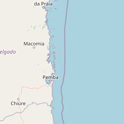
The landscape of Quirimbas National Park is defined by the dramatic interplay between coastal mainland terrain and the offshore archipelago. The mainland portion features the Taratibua region, characterized by prominent inselberg formations, which are isolated granite mountains rising abruptly from the surrounding lowland coastal plain. These geological features create a distinctive skyline and harbor unique microhabitats on their slopes and summits. The coastal zone transitions from sandy beaches through narrow mangrove belts to interior woodland and forest zones. The eleven islands within the park vary from larger landmasses with established communities to small sandy islets and coral cays. The marine environment features extensive coral reef systems stretching along the coast and surrounding the islands, interspersed with sea grass beds that provide critical habitat for marine species. The overall visual character combines the rugged beauty of the inselberg-strewn mainland with the more gentle, tropical island landscape of the archipelago.

Quirimbas National Park ecosystems, habitats, and plant life

The ecological diversity of Quirimbas National Park is exceptional, with the park protecting approximately 913,000 hectares of coastal forest, mangrove systems, and coral reef environments. The terrestrial habitats encompass a gradient from coastal savannah and woodland through to denser forest zones on the islands and inselberg slopes. The mangrove forests along the mainland coast and surrounding islands serve as critical nurseries for fish species and provide important coastal protection functions. The marine environment features well-developed coral reef systems that support extraordinary biodiversity, with 375 fish species documented within park waters. These reefs are complemented by extensive sea grass beds that provide additional habitat complexity. The isolation imposed by the Mozambican Civil War resulted in decades of limited human disturbance, allowing ecosystems to retain relatively natural character compared to more heavily impacted regions.

Quirimbas National Park wildlife and species highlights

The wildlife of Quirimbas National Park encompasses both significant terrestrial fauna and exceptional marine biodiversity. On land, the park supports sparse but notable populations of large mammals including elephants, lions, leopards, and African wild dogs, representing predator-prey relationships that have persisted in the region. Crocodiles are present in coastal and riverine habitats. The marine environment is particularly rich, with documented populations of sea turtles and dolphins regularly encountered in park waters. The reef systems support 375 identified fish species, including threatened pipefish and seahorses that inhabit the coral and sea grass environments. The birdlife is diverse given the mix of island, coastal, and forest habitats, though detailed species inventories are limited in available source material. The combination of terrestrial large mammals and marine megafauna makes Quirimbas one of Mozambique's most wildlife-diverse protected areas.

Quirimbas National Park conservation status and protection priorities

Quirimbas National Park holds significant conservation importance as one of Mozambique's largest and most ecologically diverse protected areas, protecting critical coastal forest, mangrove, and coral reef ecosystems. The park's marine protected status helps conserve spawning and nursery habitats for commercially and ecologically important fish species, while also protecting threatened marine invertebrates including pipefish and seahorses. Conservation objectives include protecting and where needed restoring both terrestrial and marine environments, with particular emphasis on marine species conservation. The park management approach emphasizes community involvement, seeking to ensure that local communities, park authorities, and tour operators share management responsibilities and benefits. A fishery management program operates within the park to support sustainable use of marine resources. Challenges identified include funding constraints for sanctuary management, ranger incentives, and follow-up on enforcement activities.

Quirimbas National Park cultural meaning and human context

The Quirimbas Islands carry significant cultural and historical importance rooted in the Swahili trading networks that historically connected East African coastal communities. Ibo Island, one of the largest in the park, features colonial-era architecture reflecting Portuguese influence and previously served as a trading post in the regional Swahili economy. The islands have been inhabited for centuries by communities whose traditional livelihoods include fishing and small-scale agriculture. The mainland coastal areas are inhabited by traditional communities whose relationship with the land and marine resources shapes the cultural landscape. The park management approach recognizes these communities as traditional inhabitants whose sustainable use practices are integrated into the conservation framework. This cultural dimension adds historical depth to the park's identity beyond its purely ecological significance.

Top sights and standout views in Quirimbas National Park

Quirimbas National Park offers a rare combination of island and mainland wilderness within a single protected area. The archipelago includes historically significant islands like Ibo with colonial-era architecture, while the mainland features dramatic inselberg landscapes. The marine environment features extensive coral reefs with more than 375 fish species, supporting regular populations of sea turtles and dolphins. The park protects populations of elephants, lions, leopards, and African wild dogs in its terrestrial zones. The diversity of habitats from mountain forests to mangrove swamps to coral reefs creates exceptional ecological complexity. The relative remoteness and limited development contribute to a wilderness character increasingly rare along the East African coast.

Best time to visit Quirimbas National Park

The optimal time to visit Quirimbas National Park depends on the type of experience sought. The dry season from May to September offers cooler temperatures and generally more comfortable conditions for exploring both islands and mainland areas. This period also tends to provide better visibility for diving and snorkeling on the coral reefs. The wet season from December to April brings higher temperatures and rainfall, but this period supports lush vegetation and may offer different wildlife viewing opportunities. Marine conditions remain suitable for water activities year-round, with water temperatures between 24 and 27 degrees Celsius. The park's tropical climate means that even the wet season sees significant sunny periods, and the seasonal changes contribute to the ecological richness that makes the park significant.

Park location guide

Geography guide, regional context, and park location map for Quirimbas National Park

Quirimbas National Park park geography, regions, and map view in Mozambique
Understand where Quirimbas National Park sits in Mozambique through a broader geographic reading of the surrounding landscape, nearby location context, and its mapped position within the national park landscape.

How Quirimbas National Park fits into Mozambique

Mozambique is a sovereign state in Southeast Africa spanning approximately 801,590 km² along the Indian Ocean. It borders Tanzania, Malawi, Zambia, Zimbabwe, Eswatini, and South Africa. The country gained independence in 1975 after Portuguese colonial rule and experienced a civil war from 1977 to 1992. Today it operates as a semi-presidential republic with a population of approximately 35 million people.

Wider geography shaping Quirimbas National Park in Mozambique

Mozambique occupies a coastal position along the Indian Ocean in southeastern Africa. The country shares borders with Tanzania to the north, Malawi and Zambia to the northwest, Zimbabwe to the west, and Eswatini and South Africa to the southwest. The terrain ranges from coastal plains to highlands in the west. The Mozambique Channel separates the country from Madagascar, Comoros, and Mayotte to the east.

Map view of Quirimbas National Park

Use this park location map to pinpoint Quirimbas National Park in Mozambique, understand its exact geographic position, and read its mapped placement within the surrounding landscape more clearly.

Pigeon | © OpenStreetMap contributors

Location context for Quirimbas National Park

Cabo Delgado Province
Park atlas

Expand your park discovery from Quirimbas National Park to explore the surrounding coastal and island protected landscapes.

Browse National Parks and Protected Areas Near Quirimbas National Park
After reviewing Quirimbas National Park, browse other national parks and protected areas that share similar coastal, marine, and terrestrial geography in Mozambique. This comparison helps you understand the broader regional spread of conservation landscapes, from island archipelagos and coral reefs to mainland inselberg formations.
Nature reserveMozambique

Niassa Reserve Nature Reserve: Mozambique's Expansive Protected Wilderness

Mapping the vast miombo woodlands and endemic species.

Niassa Reserve, a sprawling nature reserve in northern Mozambique, represents one of the largest miombo woodland ecosystems on Earth. Its diverse terrain encompasses dense forests, open savannahs, and riparian zones, making it a vital habitat for unique wildlife and a significant landmark in regional geography. The reserve's protected status and immense scale offer unparalleled opportunities for atlas-style exploration of its landscape and conservation importance.

Area
42,000 km²
Established
1954
IUCN
IV
National parkAnjouan

Shisiwani National Park: Anjouan's Protected Marine and Island Landscape Atlas

Coastal and terrestrial protected area mapping in Comoros.

Delve into the protected landscape of Shisiwani National Park, a critical national park situated on Anjouan's Sima Peninsula in Comoros. This atlas entry details the park's combined marine and terrestrial boundaries, highlighting its vital coral reefs, mangrove forests, and unique island geography. Understand the park's role in conservation through its mapped extent and diverse natural environments, offering a clear geographic context for protected area exploration.

Area
64.97 km²
Established
2016
IUCN
II
National parkAnjouan

Mount Ntringui National Park: Protected Volcanic Landscape and Highland Geography on Anjouan

Explore its dramatic peaks, crater lake, and remnant montane forests.

Mount Ntringui National Park is a significant protected area situated in the rugged volcanic highlands of Anjouan. This national park preserves the island's highest peaks, Mount Ntringui and Mount Trindrini, alongside the unique Dzialandzé crater lake and the crucial Moya Forest. It stands as a vital refuge for endemic species and represents the last substantial tract of montane forest on Anjouan, offering deep insights into the region's unique ecology and mapped natural terrain.

Area
79.14 km²
Established
2010
IUCN
II
National parkTanzania

Nyerere National Park: Tanzania's Immense Protected Area and Rufiji River Landscape

Explore the savanna and river delta geography of this national park.

Nyerere National Park represents one of Tanzania's most significant protected areas, sprawling across southeastern regions and offering a glimpse into largely untouched wilderness. The park's identity is deeply intertwined with the Rufiji River and its expansive delta, home to one of the world's largest mangrove forest systems. As a national park, its vastness and diverse terrain provide critical habitat, making it a key point for understanding protected land distribution and regional landscape context within Tanzania.

Area
30,893 km²
Established
2019
IUCN
II
National parkMalawi

Lake Malawi National Park: UNESCO Protected Landscape and Endemic Fish Habitat

Discover mapped terrain, island geography, and evolutionary wonders.

Lake Malawi National Park offers unparalleled insight into freshwater biodiversity and landscape dynamics within Malawi's Great Rift Valley. As a UNESCO World Heritage Site, it is celebrated for its spectacular evolutionary radiation of cichlid fish, a phenomenon studied globally. The park's protected territory includes the mountainous Nankumbu Peninsula and thirteen islands, providing a rich context for understanding the interplay between aquatic ecosystems, terrestrial terrain, and unique island geography.

Area
94 km²
Established
1980
IUCN
II
National parkMorogoro Region

Mikumi National Park: East African Savannah Protected Landscape in Morogoro Region

Mapped boundaries and regional geography for a key Tanzanian national park.

Mikumi National Park, a vital protected area in Tanzania's Morogoro Region, offers a classic savannah experience with iconic baobab trees and diverse wildlife populations. This national park is distinguished by its extensive alluvial plains, shaped by the Mkata River basin, and its significant role as a wilderness corridor connecting with the larger Selous Game Reserve. The park's terrain includes Malundwe Mountain and views of the Uluguru Mountains, providing a rich geographic backdrop for understanding East African protected lands and their atlas-style distribution.

Area
3,230 km²
Established
1964
IUCN
II
National parkCentral Region

Kasungu National Park: Protected Landscape and Central Region Geography Details

Explore the mapped boundaries and protected area identity.

Kasungu National Park is a protected natural area in Malawi's Central Region, serving as a vital point for geographic study and atlas-driven exploration. This entry focuses on understanding the park's specific identity as a national park, detailing its mapped boundaries and the surrounding regional geography. Users can gain insight into the landscape context and protected-area characteristics that define Kasungu National Park, enriching their understanding of Malawi's natural heritage.

Area
2,316 km²
Established
1970
IUCN
II
National parkKenya

Kisite-Mpunguti Marine National Park: Kenya's Coastal Protected Marine Landscape

Mapped coral reefs and diverse marine ecosystems.

As Kenya's foremost marine national park, Kisite-Mpunguti Marine National Park presents an unparalleled opportunity to explore a thriving underwater world. Its protected boundaries encompass remarkable coral formations and a rich tapestry of marine species, including diverse fish populations, sea turtles, and dolphins. This park is a cornerstone of coastal conservation, offering valuable insights into marine geography and ecosystem health for those seeking detailed landscape context.

Area
39 km²
Established
1973
IUCN
II

Common questions about visiting, size, designation, and location context for Quirimbas National Park

Quirimbas National Park FAQs for park facts, access, geography, and protected area context
Find quick answers about Quirimbas National Park, including protected-area facts, park geography, trail and visitor context, and how the park fits into its surrounding country and regional landscape.
MoriAtlas Explorer

Continue Your Protected Areas Search Across the Global Atlas

Deepen your exploration by continuing the structured search for national parks and protected areas worldwide. Utilize the comprehensive filtering capabilities to compare different conservation landscapes and refine your understanding of global park geography. Discover more about the distribution and characteristics of protected natural areas.

Global natural geography