

Mori Atlas logo
National parkSorkheh Hesar National Park

Discover the mapped boundaries and regional geography of this vital Iranian national park.

Sorkheh Hesar National Park: Protected Mountain Forest Landscape of Tehran Province

Sorkheh Hesar National Park represents a crucial protected forest ecosystem located in Tehran Province, Iran. This expansive national park, covering 9,380 hectares of mountainous terrain, offers a unique glimpse into Iran's conservation efforts and its natural landscapes. Its designation as a protected area underscores its ecological importance, particularly its role as habitat for threatened species and its position within the broader geographic context of the region. Users exploring this park on MoriAtlas can discover its mapped boundaries, surrounding terrain, and its contribution to the regional protected land network.

National ParkForest ReserveWildlife ConservationIranTehran ProvinceMountain Forest

Sorkheh Hesar National Park

National park

Park overview

Structured park overview, official facts, and landscape profile for Sorkheh Hesar National Park

Sorkheh Hesar National Park park facts, protected area profile, and essential visitor context

Review the core facts for Sorkheh Hesar National Park, including designation, size, terrain, visitor scale, habitats, and operating context in one park-focused overview.

About Sorkheh Hesar National Park

Sorkheh Hesar National Park represents an important protected area in northern Iran, situated within Tehran County just outside the capital's southeastern periphery. The park's location near the historic city of Ray, once a significant center of Persian civilization, places it within a region of considerable historical importance. The 9,380-hectare protected area encompasses mountainous forest terrain that rises to 1,547 meters above sea level, creating a distinct ecological zone within the otherwise semi-arid central Iranian landscape. The park's establishment as a national park in 1980 marked a significant step in Iran's conservation framework, transitioning from its earlier role as a royal hunting ground dating to 1931. This transformation from exclusive hunting preserve to protected national park reflects broader shifts in Iranian environmental policy toward species preservation and habitat protection. The park's management by the Iran Environmental Protection Organization ensures ongoing protection for its ecological resources, though the northeastern portion of the territory maintains a different administrative arrangement.

Quick facts and research context for Sorkheh Hesar National Park

Sorkheh Hesar National Park spans 9,380 hectares in Tehran County, situated at an altitude of 1,547 meters. The area experiences a semi-arid climate with the maximum annual average temperature reaching 18.9°C. Originally established as a royal hunting ground in 1931, the park received national park designation in 1980 and is managed by Iran's Environmental Protection Organization. The Jajrood River traverses the park area, flowing from the Latyan Dam region into Parchin Township. The park serves as an important wintering ground for migratory bird species.

Protection and recognition

Tracking terrestrial conservation history and official national designation records since 1980

Sorkheh Hesar National Park Protection Status and Official Designation Details

National conservation records outline the terrestrial protection status and environmental boundaries of Sorkheh Hesar National Park. Geographic database records verify the original 1980 designation timeline to clarify how the terrestrial landscape fits into regional protected area networks.

Protection details

Protection scope
Terrestrial
Designated year
1980
Park context

Deeper park guide and search-rich context for Sorkheh Hesar National Park

Sorkheh Hesar National Park history, landscape, wildlife, and travel context

Explore Sorkheh Hesar National Park through its history, landscape character, ecosystems, wildlife, conservation priorities, cultural context, and seasonal travel timing in a structured park guide built for atlas discovery and search intent.

Why Sorkheh Hesar National Park stands out

Sorkheh Hesar National Park is particularly known for its population of Persian fallow deer, a species of significant conservation concern in Iran. The park also provides habitat for the Persian leopard, one of the region's most iconic and endangered predators. The protected area serves as a critical wintering ground for migratory birds, with the forest ecosystem supporting diverse avian populations during the colder months. The combination of mountainous forest habitat near a major metropolitan area makes this park a notable example of conservation in an urban-proximate setting.

Sorkheh Hesar National Park history and protected-area timeline

The history of Sorkheh Hesar National Park reflects the evolution of conservation thinking in Iran during the twentieth century. The area was originally established as a royal hunting ground in 1931, serving as an exclusive preserve for hunting activities under the patronage of the Iranian monarchy. This designation reflected the traditional Persian practice of maintaining designated hunting territories, often with specific species protection measures. The transition to national park status in 1980 marked a fundamental change in the park's management philosophy, shifting from aristocratic recreation to public conservation. This conversion coincided with the establishment of Iran's modern environmental protection framework, which sought to balance development pressures with habitat preservation. The subsequent transfer of management authority to the Iran Environmental Protection Organization formalized the park's conservation mandate, though the northeastern portion of the territory remained under different administrative jurisdiction. The prohibition of hunting activities transformed the park from a game preserve into a genuine sanctuary for wildlife species.

Sorkheh Hesar National Park landscape and geographic character

Sorkheh Hesar National Park occupies mountainous terrain in the foothills northeast of Tehran, characterized by elevations reaching 1,547 meters above sea level. The landscape consists of forested slopes and ridgelines that rise from the surrounding semi-arid plains, creating a distinct island of woodland habitat within the broader dry central Iranian environment. The Jajrood River traverses the park area, flowing from the Latyan Dam and continuing through the territory before exiting toward Parchin Township. This watercourse provides critical hydration for the forest ecosystem and creates a riparian corridor that enhances biodiversity within the park. Access to the park is available via Khojir Road and Qasr-e-Firoozeh Road, which connect the protected area to the Tehran metropolitan region. The combination of elevation, forest cover, and water resources creates a landscape of considerable scenic and ecological value near one of the Middle East's largest cities.

Sorkheh Hesar National Park ecosystems, habitats, and plant life

The ecological character of Sorkheh Hesar National Park is defined by its forest ecosystem situated within a semi-arid climate zone. The park experiences considerable temperature variation, with hot days and cool nights creating challenging conditions for wildlife. The maximum annual average temperature in the area reaches approximately 18.9°C, while the high day-night temperature differential shapes both vegetation patterns and animal behavior. The forest vegetation provides critical habitat structure, supporting both resident species and seasonal visitors. The Jajrood River and associated riparian zones create microhabitats that support increased biodiversity compared to the surrounding terrain. The park's significance as a wintering area for migratory birds elevates its ecological importance, as the forest provides roosting and foraging resources during the cold months when birds move south from more northerly breeding grounds.

Sorkheh Hesar National Park wildlife and species highlights

Sorkheh Hesar National Park supports a diverse mammalian fauna that reflects the park's position within Iran's mountain forest ecosystems. The Persian fallow deer represents one of the park's most significant species, as this deer is endemic to the Middle East and remains endangered throughout its range. The Persian leopard, another regionally endemic large predator, occupies the park's terrain and represents one of Iran's most cherished conservation targets. Smaller mammals include the red fox and cape hare, which are more widely distributed but nonetheless form important components of the park's food web. The avian community features prominent species including the golden eagle and various hawk species, which utilize the park's open areas and forest edges for hunting. Reptiles are represented by various snake species within the park. The historical use of the area as a hunting ground underscores the richness of its wildlife populations, though contemporary protections ensure these species can persist without the pressures of commercial or recreational hunting.

Sorkheh Hesar National Park conservation status and protection priorities

Sorkheh Hesar National Park plays a significant role in Iran's conservation framework by protecting forest habitat for several species of regional and global conservation concern. The Persian fallow deer population represents a particular conservation priority, as this species has experienced significant range contraction across its Middle Eastern distribution. Similarly, the Persian leopard persists in only a limited number of protected areas within Iran, making each protected population important for species survival. The park's designation as a national park in 1980 and its management by the Iran Environmental Protection Organization provide formal protection frameworks, though enforcement in a park situated near a major metropolitan area presents ongoing challenges. The migration bird function adds another dimension to the park's conservation value, as the protected forest provides essential wintering habitat for species that traverse the Flyway between Europe and Africa. The strict prohibition on hunting activities represents a fundamental conservation measure that allows wildlife populations to recover from historical exploitation.

Sorkheh Hesar National Park cultural meaning and human context

Sorkheh Hesar National Park is situated near Ray, also known as Rey, a city of considerable historical significance in Iranian civilization. Ray has been an important settlement since ancient times and served as a regional capital under various Persian dynasties. The park's proximity to this historic city connects the protected area to centuries of Persian land use and cultural development. The area's traditional role as a royal hunting ground also reflects the historical relationship between Persian rulers and the landscape, a pattern evident throughout Iranian history. While the park itself does not contain major archaeological sites, its location within the broader cultural landscape of the Tehran-Ray corridor connects conservation efforts to regional heritage values.

Top sights and standout views in Sorkheh Hesar National Park

Sorkheh Hesar National Park offers a combination of accessibility and ecological significance that makes it distinctive among Iran's protected areas. The park's proximity to Tehran provides urban residents with convenient access to mountain forest environments, rare in the otherwise semi-arid central Iranian landscape. The presence of Persian fallow deer and Persian leopard provides wildlife viewing opportunities for visitors who explore the park's trails, though these species are elusive and sightings require patience. The winter bird migration creates a particularly dynamic season when the forest hosts numerous species that are absent during summer months. The Jajrood River corridor adds aquatic habitat diversity and supports riparian vegetation that contrasts with the surrounding terrain. The park's transition from royal hunting ground to national park represents a conservation success story that demonstrates the potential for protected areas to recover when given proper legal protection.

Best time to visit Sorkheh Hesar National Park

Sorkheh Hesar National Park can be visited throughout the year, though different seasons offer distinct experiences. The spring and autumn seasons typically provide the most comfortable temperatures for hiking and wildlife observation, with moderate daytime temperatures and cooler evenings. Winter brings colder conditions to the elevated park, but this season coincides with the peak period for migratory bird presence as species from northern regions winter in the forest habitat. Summer months feature higher temperatures typical of the semi-arid climate, though the forest canopy provides some relief from the heat. Visitors interested in wildlife observation should consider that early morning hours offer the best chances for seeing active animals, while the park's mountain trails provide opportunities for panoramic views of the Tehran metropolitan area and surrounding landscape.
Monthly climate preview

Long term temperature ranges and monthly precipitation patterns in Tehran Province

Sorkheh Hesar National Park Climate Normals and Weather by Month

Long-term data at an elevation of 1555 meters shows wide annual temperature swings ranging from sub-zero winter lows to hot summer peaks above 37 degrees Celsius, paired with low year-round precipitation. Comparing historical monthly climate normals provides a precise view of these seasonal changes in Tehran Province.
Annual mean14 °C
1 °C28 °C
Jan
Feb
Mar
Apr13°
May19°
Jun25°
Jul28°
Aug26°
Sep22°
Oct15°
Nov
Dec
Warmest month
July

27.5 °C

Coolest month
January

0.8 °C

Wettest month
November

1.3 mm/day

Driest month
June

0.2 mm/day

Park location guide

Geography guide, regional context, and park location map for Sorkheh Hesar National Park

Sorkheh Hesar National Park park geography, regions, and map view in Iran

Understand where Sorkheh Hesar National Park sits in Iran through a broader geographic reading of the surrounding landscape, nearby location context, and its mapped position within the national park landscape.

How Sorkheh Hesar National Park fits into Iran

Iran is a West Asian nation with a population exceeding 92 million, making it the 17th most populous country globally. It borders seven countries and has coastlines along the Caspian Sea, Persian Gulf, and Gulf of Oman. Tehran is the capital and largest city, while Persian is the official language.

Wider geography shaping Sorkheh Hesar National Park in Iran

Iran occupies a strategic position in West Asia, bordering Iraq to the west, Turkey, Azerbaijan, and Armenia to the northwest, Turkmenistan to the northeast, Afghanistan to the east, and Pakistan to the southeast. It has coastlines along the Caspian Sea to the north, the Persian Gulf to the south, and the Gulf of Oman to the southeast. The terrain includes mountain ranges such as the Zagros and Alborz, as well as arid desert areas.

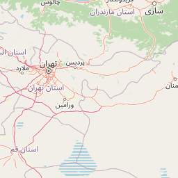
Map view of Sorkheh Hesar National Park

Use this park location map to pinpoint Sorkheh Hesar National Park in Iran, understand its exact geographic position, and read its mapped placement within the surrounding landscape more clearly.

Pigeon | © OpenStreetMap contributors

Location context for Sorkheh Hesar National Park

Tehran Province
Recorded earthquake history

Browse the Historical Earthquake Catalogue for Sorkheh Hesar National Park

Investigate the history of recorded seismic events associated by location with Sorkheh Hesar National Park. MoriAtlas provides this catalogue to help users understand the regional seismic context of the park without assessing future hazard or risk.

Sorkheh Hesar National Park Earthquake Records

Catalogued events

10 events

Strongest magnitude

Magnitude 4.9

Most recent event

May 12, 2026

This history includes earthquakes recorded inside the park or within 50 km of its borders

Park atlas

Browse the Surrounding Protected Landscapes and Compare Mountain Forest Reserves in Tehran Province, Iran

Explore Other National Parks Near Sorkheh Hesar National Park: Related Protected Areas and Regional Geography

After exploring Sorkheh Hesar National Park's unique mountain forest and wildlife, continue your protected area discovery by browsing other national parks and reserves across Tehran Province and central Iran. Compare diverse conservation landscapes, understand regional ecological connections, and map the spread of protected zones near urban areas.
National parkMazandaran Province
About 43 km away#1 closest

Northeast

Lar National Park National Park: Mapped Protected Landscape and Alborz Geography

Alpine terrain and regional context within Mazandaran Province.

Lar National Park stands as a critical national park, encompassing approximately 30,000 hectares of alpine and sub-alpine wilderness in Mazandaran Province, Iran. Its protected landscape is characterized by steep mountain valleys and ridgelines, situated at the southern base of Mount Damavand. This atlas-focused view reveals the park's mapped boundaries and its significant geographic position within the Central Alborz mountain range, crucial for understanding Iran's protected natural areas.

Area
300 km²
Established
1976
IUCN
II
Relief
Mountain
National parkIran
89 km away#2 closest

Southeast

Kavir National Park: A Major Protected Desert Landscape in Iran

Explore its arid terrain, conservation significance, and mapped boundaries.

Kavir National Park stands as a significant protected area within Iran, encompassing a vast 4,000 square kilometer expanse of desert and steppe landscapes on the western flank of the Kavir Desert. Designated as a national park, it plays a crucial role in preserving one of the Middle East's most extensive arid ecosystems and serves as a critical sanctuary for endangered species, including the Asiatic cheetah and Persian leopard. Its stark, open terrain offers a profound example of Iran's natural heritage and provides essential data for understanding regional geography and protected land distribution.

Area
4,000 km²
Established
1982
IUCN
II
Relief
Lowland
National parkSemnan Province
384 km away#3 closest

East

Khar Turan National Park: A Vast Protected Landscape and Critical Cheetah Habitat in Iran

Explore Semnan Province's premier national park, mapped desert terrain, and vital wildlife refuge.

Khar Turan National Park is a significant protected landscape in Iran's Semnan Province, renowned for its expansive arid and semi-desert terrain. As the country's second-largest national park and a UNESCO Biosphere Reserve, it plays a critical role in conserving biodiversity, notably as a last bastion for the critically endangered Asiatic cheetah and Persian onager. Its diverse geography, from mountains to salt pans, offers a compelling atlas of life adapted to harsh desert conditions.

Area
14,000 km²
IUCN
II
Relief
Mixed relief
Climate
Arid
Watercolor painting showing rolling green hills, a body of water, and distant mountains
National parkLankaran Rayon
About 408 km away#4 closest

Northwest

Hirkan National Park: Ancient Hyrcanian Forest Protected Area in Lankaran Rayon

Explore mapped boundaries and unique regional geography.

Hirkan National Park stands as a significant protected area in Azerbaijan, renowned for its extensive old-growth Hyrcanian forests. This national park offers a unique window into ancient temperate rainforest ecosystems, featuring remarkable vertical forest zonation and a high concentration of endemic species within the Talysh Mountains and Lankaran Lowland. Its designation as part of the UNESCO World Heritage Hyrcanian Forests underscores its global importance for conservation and atlas-based geographic exploration of unique, relic landscapes.

Area
403.58 km²
Established
2004
IUCN
II
Relief
Mixed relief
Nature reserveLankaran District
About 436 km away#5 closest

Northwest

Ghizil-Agaj State Reserve: Mapping the Caspian Coastal Protected Landscape in Azerbaijan

Regional geography and wetland terrain in Lankaran District

Spanning the shallow inlets of the southwestern Caspian Sea, Ghizil-Agaj State Reserve represents a critical protected wetland area. Its geography is defined by a transition between open water, marshy coastal strips, and salt-affected semi-desert zones. By analyzing the reserve's boundaries and hydrological features, one gains a clearer understanding of how this significant natural landscape functions within the broader environmental context of the South Caucasus.

Area
884 km²
Established
1929
Relief
Lowland
Climate
Subtropical
National parkGolestan province
About 471 km away#6 closest

Northeast

Golestan National Park: Mapped Protected Area in Golestan Province, Iran

Explore its geographic context and landscape identity.

Golestan National Park is a designated national park situated in Iran's Golestan province. This page details its protected landscape, offering insights into its geographic placement and mapped boundaries. Ideal for users seeking to understand the park's role within regional geography and its specific natural terrain features, this entry serves as a primary atlas point for Golestan National Park.

Area
918.95 km²
IUCN
II
Relief
Mountain
Climate
Temperate
National parkAzerbaijan
About 479 km away#7 closest

Northwest

Shirvan National Park: Azerbaijan's Unique Protected Semi-Desert Ecosystem and Geography

Discover the mapped landscape, gazelle habitats, and wetland geography.

Shirvan National Park, located in Azerbaijan's Shirvan Lowland, safeguards a remarkable semi-desert environment situated on a former Caspian Sea floor. This protected area is distinguished by its low-lying terrain, ancient coastal ridges, and dune formations, providing essential habitat for the world's largest concentration of goitered gazelles. Wetlands around Çala Lake also support significant migratory bird populations, making Shirvan a crucial protected landscape for both terrestrial and avian wildlife and a key site for regional geographic study.

Area
543.735 km²
Established
2003
IUCN
II
Relief
Lowland
Nature reserveAzerbaijan
About 480 km away#8 closest

Northwest

Shirvan State Reserve: Nature Reserve and Protected Landscape in Azerbaijan

A detailed look at the Kura-Araxes saline-steppe and wetland geography

Shirvan State Reserve is a strictly protected nature reserve in southeastern Azerbaijan that encompasses a vast saline-steppe and wetland mosaic. The terrain features wind-shaped sand mounds, expansive reedbeds, and the shallow Lake Chala, all of which define the unique Caspian lowland environment. This area provides an essential refuge for migratory waterbirds and serves as a primary site for gazelle conservation efforts in the Kura-Araxes basin.

Area
62.32 km²
Established
1969
Relief
Lowland
Climate
Temperate

Common questions about visiting, size, designation, and location context for Sorkheh Hesar National Park

Sorkheh Hesar National Park FAQs for park facts, access, geography, and protected area context

Find quick answers about Sorkheh Hesar National Park, including protected-area facts, park geography, trail and visitor context, and how the park fits into its surrounding country and regional landscape.
MoriAtlas Explorer

Continue Your Protected Areas Search Across the Global Atlas

Deepen your exploration by continuing the structured search for national parks and protected areas worldwide. Utilize the comprehensive filtering capabilities to compare different conservation landscapes and refine your understanding of global park geography. Discover more about the distribution and characteristics of protected natural areas.

Global natural geography
