Mori Atlas logo
National parkSundarbans National Park

Discover its intricate tidal geography, mapped protected boundaries, and unique estuarine landscape.

Sundarbans National Park: A UNESCO World Heritage Mangrove National Park in West Bengal

(Sundarbans National Park, West Bengal)

Sundarbans National Park represents a globally significant protected landscape on the Ganges Delta, recognized as a UNESCO World Heritage Site and the world's largest mangrove forest. Situated in West Bengal, India, this national park encompasses a unique estuarine environment shaped by complex tidal channels and distributaries, offering unparalleled insight into coastal wetland geography and protected area dynamics. Explore the mapped boundaries and distinctive natural terrain that shelters one of the last strongholds of the Bengal tiger, providing a rich context for atlas-based discovery.

Mangrove ForestUNESCO World Heritage SiteTiger ReserveRamsar SiteEstuarine DeltaBiosphere Reserve

Sundarbans National Park

National park

Park overview

Structured park overview, official facts, and landscape profile for Sundarbans National Park

Sundarbans National Park park facts, protected area profile, and essential visitor context
Review the core facts for Sundarbans National Park, including designation, size, terrain, visitor scale, habitats, and operating context in one park-focused overview.

About Sundarbans National Park

Sundarbans National Park represents one of the most ecologically significant and geographically unique protected areas in the world. Located on the Indian side of the Sundarbans, which spans the border between India and Bangladesh, this national park encompasses a vast tract of mangrove forest on the Ganges Delta, one of the largest river deltas in the world. The park's landscape is defined by its intricate network of tidal channels, mudflats, and 54 distinct islands that are continuously reshaped by the interplay of river sediment deposition and tidal action. The eco-geography of this area is entirely dependent on the twice-daily tidal cycles, with tidal ranges of 3 to 5 meters and up to 8 meters during spring tides, inundating the forest in varying depths. This dynamic environment has produced a remarkably specialized ecosystem where vegetation has adapted to survive in constantly changing salinity and inundation conditions. The Sundarbans derives its name from the Sundari tree, a distinctive mangrove species valued for its beauty and economic importance. The park serves as the core zone of the larger Sundarbans Tiger Reserve, which encompasses a total area of 2,585 square kilometers including both forest and populated regions, making it one of the largest tiger reserves in India and a critical conservation landscape for the survival of the Bengal tiger.

Quick facts and research context for Sundarbans National Park

Sundarbans National Park covers 1,330.10 square kilometers of mangrove forest on the Ganges Delta in West Bengal, India. The average elevation is 7.5 meters above sea level, with the park situated between 21°43′ and 21°55′ N latitude and 88°42′ and 89°04′ E longitude. The delta experiences a tropical climate with heavy monsoon rainfall from mid-June to mid-September, humidity reaching 80%, and temperatures ranging from 20°C to 48°C. The park is administered by the Directorate of Forest under the Principal Chief Conservator of Forests, Wildlife & Bio-Diversity & ex-officio Chief Wildlife Warden of West Bengal, with local management headed by the Chief Conservator of Forests (South) & Director, Sundarban Biosphere Reserve. The park receives funding through Project Tiger and the Ministry of Environment and Forests.

Park context

Deeper park guide and search-rich context for Sundarbans National Park

Sundarbans National Park history, landscape, wildlife, and travel context
Explore Sundarbans National Park through its history, landscape character, ecosystems, wildlife, conservation priorities, cultural context, and seasonal travel timing in a structured park guide built for atlas discovery and search intent.

Why Sundarbans National Park stands out

Sundarbans National Park is best known as the home of the Bengal tiger in one of the world's most unique ecological settings, where tigers have adapted to survive in a tidal mangrove environment. The park contains the world's largest contiguous mangrove forest, a UNESCO World Heritage Site since 1987, protecting a complex ecosystem shaped by the twice-daily tidal cycles of the Bay of Bengal. It is famous for its population of royal Bengal tigers, which are known for their swimming abilities and have developed unique behavioral adaptations to navigate the labyrinthine water channels and island forests. Beyond tigers, the park protects significant populations of saltwater crocodiles, rare river terrapins, and serves as critical habitat for marine mammals including Irrawaddy dolphins, Ganges river dolphins, and Bryde's whales. The Sundari tree, from which the Sundarbans derives its name, dominates the mangrove canopy with its distinctive pneumatophore root systems that emerge from the waterlogged soil to facilitate respiration.

Sundarbans National Park history and protected-area timeline

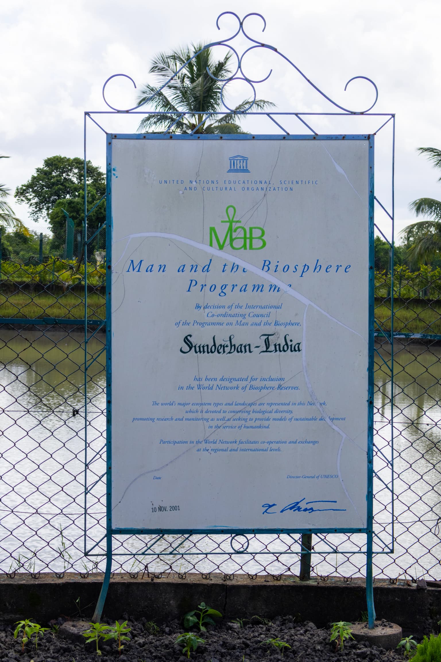
The conservation history of Sundarbans dates back to 1869 when the first forest management division was established to have jurisdiction over the region. In 1875, a large portion of the mangrove forests was declared as reserved forests under the Forest Act of 1865, with the remaining portions following the next year. The forest, previously administered by civil district authorities, was placed under the control of the Forest Department in 1876. A forest division was created in 1879 with headquarters in Khulna, Bangladesh, serving as the basic administrative unit for forest management. The first formal management plan was written for the period 1893 to 1898. The present protected area was designated as the core area of Sundarban Tiger Reserve in 1973 and received wildlife sanctuary status in 1977. On May 4, 1984, it was officially declared a national park. The Sundarbans was recognized as a Biosphere Reserve under the Man and the Biosphere Programme on November 10, 2001, and was inscribed as a Ramsar wetland on January 30, 2019. The area has faced significant challenges from natural disasters, including Cyclone Aila in 2009 and Cyclone Amphan in 2020, both of which caused substantial damage to infrastructure and management facilities.

Sundarbans National Park landscape and geographic character

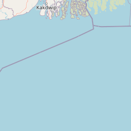
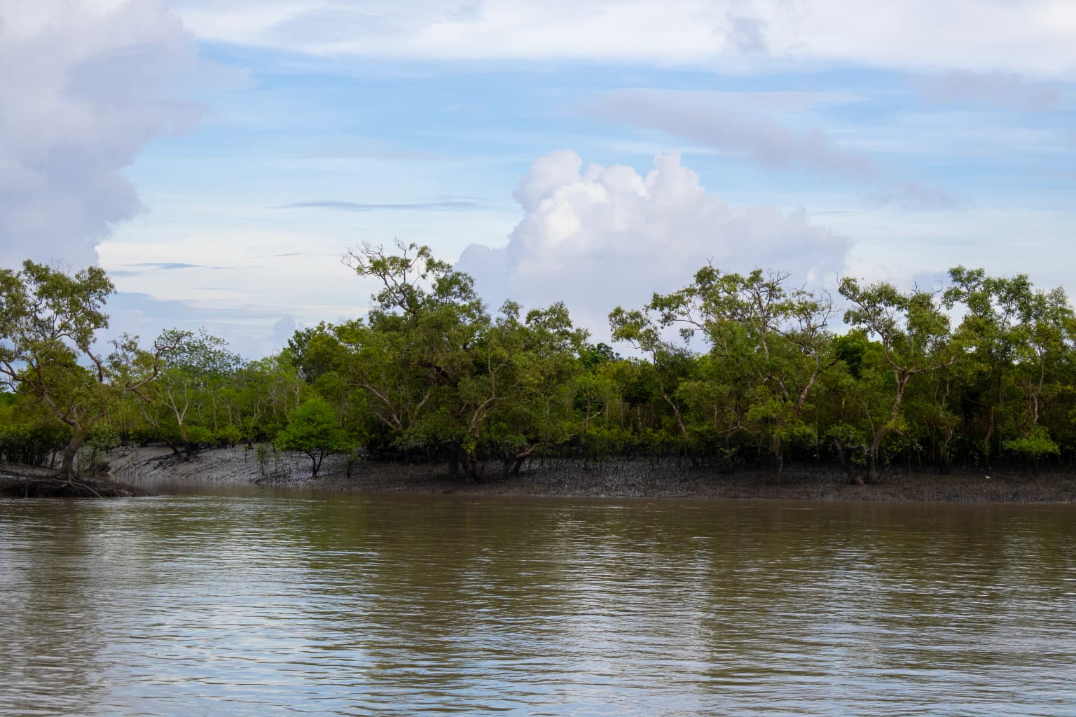
The landscape of Sundarbans National Park is characterized by its distinctive mangrove forest ecosystem on a vast estuarine delta. The terrain is extremely flat, with an average altitude of just 7.5 meters above sea level, making it one of the lowest-lying protected areas in the world. The park is composed of 54 small islands that are separated by a complex network of distributaries and tidal channels radiating from the Ganges River. Seven main rivers and countless smaller watercourses create an intricate maze of waterways that dominate the physical geography. The landscape features extensive mudflats at the estuary and on deltaic islands, which are exposed during low tides and submerged during high tides, changing morphology even within a single tidal cycle. A remarkable geological feature called the Swatch of No Ground exists in the Bay of Bengal between 21°00' and 21°22' latitude, where water depths change dramatically from 20 meters to 500 meters, influencing sediment deposition patterns and island formation. The mangrove vegetation creates a distinctive landscape where the Sundari tree dominates the canopy, with specialized pneumatophore roots rising above the waterlogged ground to enable gas exchange during the monsoon season when the entire forest is submerged.

Sundarbans National Park ecosystems, habitats, and plant life

Sundarbans National Park harbors a unique estuarine ecosystem of exceptional ecological significance. The mangrove forests represent the largest contiguous mangrove system on the Indian subcontinent, supporting a complex web of specialized flora and fauna adapted to the brackish water environment. The vegetation is dominated by the Sundari tree, from which the region derives its name, along with other mangrove species including the mangrove date palm. These trees have evolved specialized aerial roots called pneumatophores that emerge above the waterlogged ground to facilitate respiration during the rainy season when the forest floor is completely inundated. The ecosystem is shaped by the twice-daily tidal cycles that bring nutrient-rich sediments and saline water, creating constantly changing conditions that support high biodiversity despite the challenging environment. The mangrove forests provide critical ecosystem services including coastal protection, carbon sequestration, nursery functions for fish and crustaceans, and flood moderation. A 2015 economic assessment valued the national park's annual ecosystem services at approximately ₹12.8 billion, with significant contributions from nursery function, gene-pool protection, fish provisioning, and waste assimilation services.

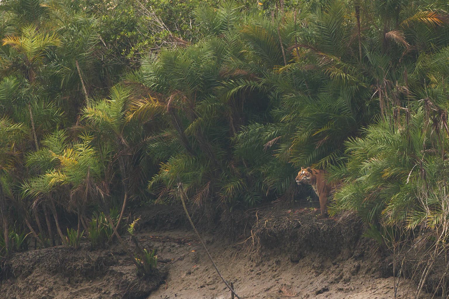
Sundarbans National Park wildlife and species highlights

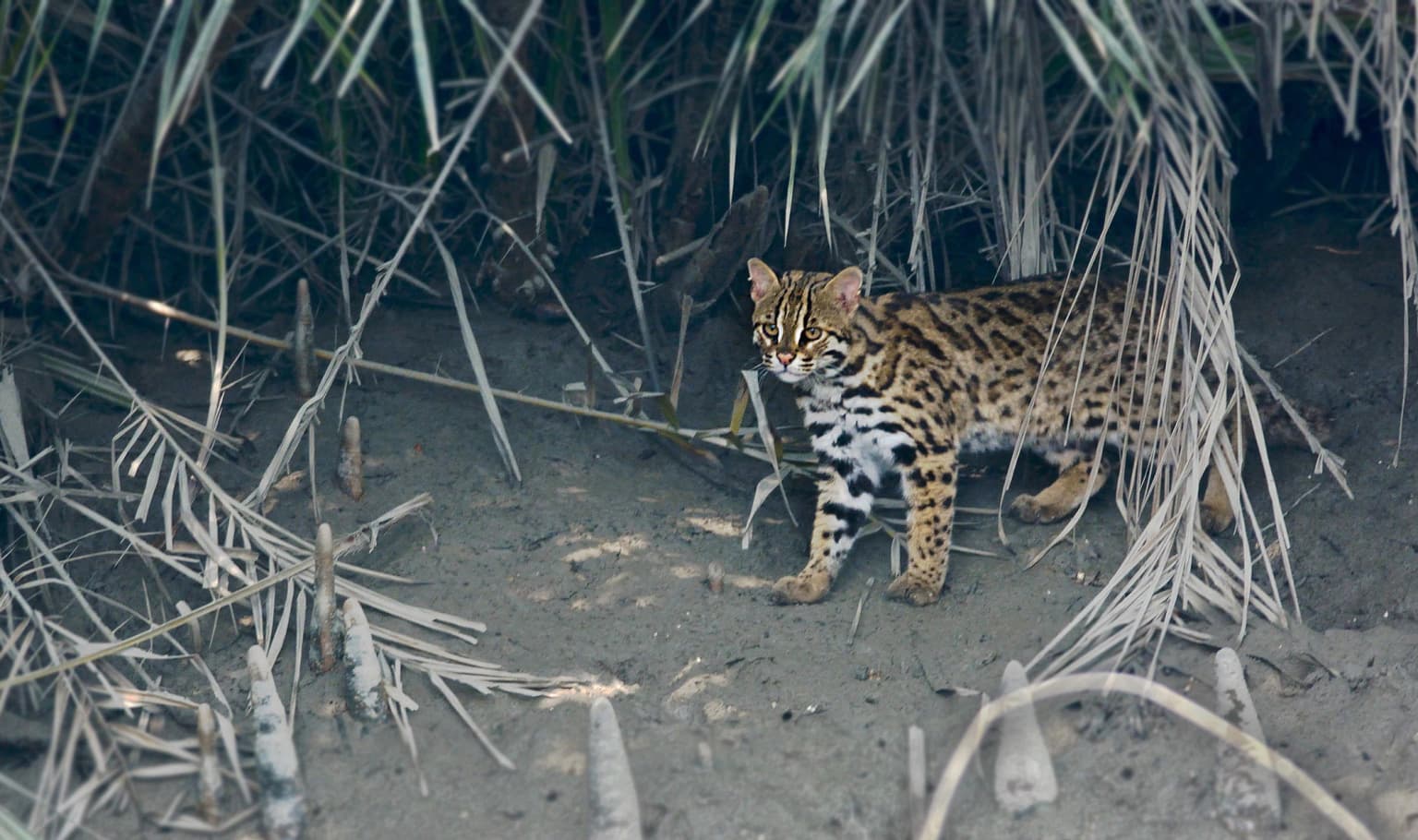
The wildlife of Sundarbans National Park is renowned for its exceptional adaptation to the tidal mangrove environment. The Bengal tiger is the flagship species, with the Sundarbans supporting one of the largest populations of this iconic predator in the world. These tigers have developed unique adaptations including swimming prowess and the ability to tolerate brackish water, making them distinct from tiger populations elsewhere. The park is home to several endangered species including the saltwater crocodile, river terrapin, olive ridley turtle, hawksbill turtle, Ganges river dolphin, and the mangrove horseshoe crab. The marine mammal diversity is remarkable, with the proposed Sundarbans Cetacean Diversity Protected Area hosting endangered cetaceans including resident groups of Bryde's whales, Irrawaddy dolphins, spinner dolphins, Ganges river dolphins, and Chinese white dolphins. Indo-Pacific finless porpoises, bottlenose dolphins, and pantropical spotted dolphins are regularly found in the area. Other notable species include the fishing cat, spotted deer or chital, rhesus monkey, and wild pig. The birdlife includes numerous species adapted to the mangrove and wetland habitats, making the park significant for avian biodiversity.

Sundarbans National Park conservation status and protection priorities

Sundarbans National Park holds exceptional conservation significance as a UNESCO World Heritage Site, Ramsar wetland, and biosphere reserve. The park forms the core of the Sundarbans Tiger Reserve, which is crucial for the survival of the Bengal tiger in the wild. Conservation efforts focus on anti-poaching activities, habitat management, and community engagement through Forest Protection Committees and Eco-development Committees formed in the fringe villages. The management addresses the unique challenge of human-tiger conflict, with measures including nylon fencing, solar illumination of villages, human mask barriers, and alternative income generation programs that have reduced casualties from approximately 40 to 10 per year. The park faces significant challenges from its geography, with a hostile terrain criss-crossed by numerous rivers, a long international border with Bangladesh, and pressure from fishing activities. Climate change and cyclonic storms pose ongoing threats, with Cyclone Amphan in 2020 causing extensive damage to infrastructure including protective fencing. Conservation priorities include managing the delicate balance between protection and the needs of approximately 1,000 villages surrounding the park that depend on forest resources.

Sundarbans National Park cultural meaning and human context

The Sundarbans region has a long history of human interaction with the mangrove ecosystem. Local communities have traditionally collected honey and wax from the forest under license from the Indian Forest Service, with approximately 50 metric tonnes of honey and 3 metric tonnes of wax collected annually. The region is home to approximately 1,000 villages in the fringe areas of the tiger reserve, whose residents have developed unique relationships with the forest and its resources. The Sundarbans has been described historically as a tract of unexamined waste country, stretching roughly 266 kilometers from the mouth of the Hooghly River to the mouth of the Meghna river. Traditional livelihoods include fishing, wood collection, and honey gathering, activities that continue in the buffer zones while the core area remains protected from such disturbances. Cultural practices and local knowledge related to the mangrove environment have developed over generations, though the relationship between local communities and the tiger population has historically been marked by conflict due to the tigers' occasional predation on humans.

Top sights and standout views in Sundarbans National Park

Sundarbans National Park offers visitors a unique opportunity to experience one of the world's most distinctive ecosystems. The primary attraction is the chance to observe Bengal tigers in their natural mangrove habitat, a rare wildlife experience available nowhere else on Earth. The park is best explored by boat along the labyrinthine tidal channels, with local boats and vessels operated by the West Bengal Tourism Development Corporation providing access to this water-bound wilderness. Notable visitor attractions include watch towers at Sudhanyakali, Dobanki, Burirdabri, and Netidhopani, which provide elevated viewpoints for wildlife observation. The Sajnekhali Bird Sanctuary, Bhagabatpur Crocodile Project crocodile breeding farm, and the Mangrove Interpretation Centre at Sajnekhali offer additional educational opportunities. The park's significance extends beyond wildlife to include its role as a critical coastal buffer against cyclones and storms, with the mangrove forests providing essential protection to surrounding communities. The ecosystem services provided by the Sundarbans, valued at billions of rupees annually, underscore its importance to both ecological and human welfare.

Best time to visit Sundarbans National Park

The best time to visit Sundarbans National Park is during the winter months from October to March when the weather is relatively comfortable with cooler temperatures and lower humidity. This period corresponds with the prevailing north and north-easterly winds and offers more stable conditions for boat-based exploration of the park. The monsoon season from mid-June to mid-September brings heavy rainfall and the park experiences significant flooding, which can restrict access and make wildlife viewing more challenging. The period from May to October is also characterized by the possibility of cyclonic storms, which can develop into severe weather events as evidenced by past cyclones like Aila in 2009 and Amphan in 2020. Visitors planning trips during the summer months should be prepared for extremely high temperatures that can reach up to 48°C along with high humidity. The post-monsoon period offers the advantage of seeing the forest in its full green glory, though the tidal dynamics remain a defining feature of the park year-round.

Park location guide

Geography guide, regional context, and park location map for Sundarbans National Park

Sundarbans National Park park geography, regions, and map view in India
Understand where Sundarbans National Park sits in India through a broader geographic reading of the surrounding landscape, nearby location context, and its mapped position within the national park landscape.

How Sundarbans National Park fits into India

India is a South Asian country bordered by the Indian Ocean, Arabian Sea, and Bay of Bengal. It shares land borders with Pakistan, China, Nepal, Bhutan, Bangladesh, and Myanmar. The country has a population of over 1.4 billion people and operates as a federal parliamentary republic with its capital in New Delhi.

Wider geography shaping Sundarbans National Park in India

India occupies the Indian subcontinent in South Asia, bordered by the Arabian Sea to the southwest, the Bay of Bengal to the southeast, and the Indian Ocean to the south. It shares land borders with Pakistan to the west, China, Nepal, and Bhutan to the north, and Bangladesh and Myanmar to the east. The territory also includes the Andaman and Nicobar Islands in the Indian Ocean.

Map view of Sundarbans National Park

Use this park location map to pinpoint Sundarbans National Park in India, understand its exact geographic position, and read its mapped placement within the surrounding landscape more clearly.

Pigeon | © OpenStreetMap contributors

Location context for Sundarbans National Park

South 24 ParganasWest Bengal
Park atlas

Compare its unique mangrove delta ecosystem with other protected areas across the surrounding Ganges Delta region and mapped coastal landscapes.

Discover Other National Parks and Protected Areas Near Sundarbans National Park, India
Explore other national parks and protected areas near Sundarbans National Park, extending your discovery across the Indian subcontinent's diverse conservation landscapes. This atlas view helps compare different park geographies, tracing the regional spread of unique ecosystems beyond Sundarbans' tidal mangrove forests.
National parkChittagong District

Baroiyadhala National Park: A Vital Wildlife Corridor and Protected Forest Landscape in Bangladesh

Discover its terrain, mapped boundaries, and regional significance.

Baroiyadhala National Park, situated in Bangladesh's Chittagong District, stands as a critical national park dedicated to preserving forest ecosystems and functioning as an essential wildlife corridor. The park's undulating terrain and dense vegetation are vital for supporting threatened species and maintaining habitat connectivity. This page offers an atlas-style exploration of Baroiyadhala National Park, detailing its protected area status, geographic context within the Chittagong region, and its significance for conservation in South Asia, providing a rich understanding of its natural landscape.

Area
29.34 km²
Established
2010
IUCN
II
National parkTripura

Clouded Leopard National Park: National Park Protected Area in Tripura's Forested Landscape

Mapped primate habitat and regional geography in Northeast India.

Clouded Leopard National Park serves as a critical protected area within Tripura, India, focusing on the conservation of its forest ecosystems and primate populations, including the Phayre's langur. As part of the larger Sepahijala Wildlife Sanctuary, its mapped boundaries contribute to the regional protected landscape. This national park offers valuable insight into the natural terrain and biodiversity specific to Northeast India, providing a unique geographic focus for atlas exploration.

Area
5.08 km²
Established
2007
IUCN
II
National parkCox's Bazar District

Medhakachhapia National Park: Protected Mangrove Landscape and Geography in Cox's Bazar

Mapping the boundaries of a unique coastal Bangladesh National Park.

Medhakachhapia National Park is a distinct protected area in Cox's Bazar District, Bangladesh, renowned for its old-growth Rhizophora apiculata mangrove forest. Spanning approximately 396 hectares, it serves as a crucial habitat and represents a specific type of tropical coastal landscape. This park's designation as a national park highlights its conservation importance, particularly its role in protecting some of Bangladesh's most mature mangrove stands. Explore its geographic context and protected status for a deeper understanding of its natural landscape.

Area
3.959 km²
Established
2008
IUCN
IV
National parkRangamati District

Kaptai National Park: Protected Landscape and Geographic Context in Rangamati District

Explore its mixed evergreen forest and lakeside terrain.

Kaptai National Park is a crucial protected area located in Bangladesh's Rangamati District, renowned for its mixed evergreen forests and unique position adjacent to Kaptai Lake. This detail page provides an atlas-oriented perspective on the park's geographic identity, mapped boundaries, and its role within the diverse Chittagong Hill Tracts region. Understand the terrain, from rolling hills to lakeside environments, and appreciate its conservation significance as a national park.

Area
54.64 km²
Established
1999
IUCN
II
Climate
Subtropical
National parkMoulvibazar District

Lawachara National Park: Protected National Park Landscape in Moulvibazar District

Mapped Terrain and Endangered Primate Habitat Exploration

Delve into the protected landscape of Lawachara National Park, a key national park located in the distinct undulating terrain of Moulvibazar District, Bangladesh. This area is recognized for its ecological significance, particularly as a sanctuary for endangered primates, including the critically important western hoolock gibbon population. Users can explore the park's mapped boundaries, understand its semi-evergreen forest ecosystem, and appreciate its geological features like sandstone hillocks and sandy-bedded streams, making it a valuable point of discovery for regional geography and conservation landscapes.

Area
12.5 km²
Established
1996
IUCN
II
National parkWest Garo Hills district

Nokrek National Park: Protected Mountain Landscape and Regional Geography

Explore its mapped boundaries and diverse natural terrain.

Nokrek National Park is a vital protected mountain wilderness situated in the West Garo Hills district, Meghalaya, India. Its rugged terrain, characterized by ancient geological formations and dense evergreen forests, supports remarkable biodiversity. As a key component of the Nokrek Biosphere Reserve, it offers a unique glimpse into the region's ecological significance, serving as an important source for major rivers and a sanctuary for diverse flora and fauna.

Area
47.48 km²
Established
1986
IUCN
II
Relief
Mountain
National parkChin State

Natmataung National Park: Protected Mountain Landscape and Biodiversity Atlas in Chin State

Explore the mapped terrain and elevational gradients of Mount Victoria.

Natmataung National Park, located in Chin State, Myanmar, offers a profound encounter with dramatic mountainous terrain and exceptional biodiversity. As a protected national park, it safeguards Mount Victoria, the highest peak in the region, and a remarkable ecological gradient spanning diverse forest types. This page provides an atlas-focused view of its geography, highlighting the steep ridgelines, deep valleys, and unique habitats that define this significant protected landscape and its role in watershed protection.

Area
723 km²
Established
2010
IUCN
II
National parkAlipurduar district

Jaldapara National Park: India's Premier Grassland and Rhino Conservation Landscape

Explore mapped boundaries and savanna terrain in Alipurduar district.

Jaldapara National Park is a protected national park in India's Alipurduar district, celebrated for its expansive rolling grasslands and significant population of Indian one-horned rhinoceros. This protected area showcases a distinctive savanna landscape, an unusual feature among Indian national parks, interspersed with riverine forests. Its elevation of 61 meters above sea level positions it at the edge of the Eastern Himalayas, offering a unique geographic setting for understanding regional biodiversity and conservation efforts.

Area
216.51 km²
Established
2014
IUCN
II

Common questions about visiting, size, designation, and location context for Sundarbans National Park

Sundarbans National Park FAQs for park facts, access, geography, and protected area context
Find quick answers about Sundarbans National Park, including protected-area facts, park geography, trail and visitor context, and how the park fits into its surrounding country and regional landscape.
MoriAtlas Explorer

Continue Your Protected Areas Search Across the Global Atlas

Deepen your exploration by continuing the structured search for national parks and protected areas worldwide. Utilize the comprehensive filtering capabilities to compare different conservation landscapes and refine your understanding of global park geography. Discover more about the distribution and characteristics of protected natural areas.

Global natural geography