Mori Atlas logo
National parkToonumbar National Park

Discover the mapped boundaries and diverse ecosystems of this significant protected area in Australia's World Heritage Gondwana Rainforests.

Toonumbar National Park: Ancient Gondwanan Rainforests and Volcanic Landscapes in New South Wales

Toonumbar National Park, situated in New South Wales, Australia, is a vital protected area preserving the continent's most ancient and ecologically rich Gondwanan rainforests. This national park is renowned for its dramatic volcanic topography, featuring the weathered remnants of the Focal Peak Volcano like Mount Lindesay and Dome Mountain. Users can explore detailed park geography, understand its mapped landscape context, and appreciate the exceptional biodiversity housed within its extensive subtropical and temperate rainforests.

RainforestWorld Heritage SiteGondwana RainforestsVolcanic LandscapeNorthern Rivers NSWMarsupials

Toonumbar National Park

National park

Park overview

Structured park overview, official facts, and landscape profile for Toonumbar National Park

Toonumbar National Park park facts, protected area profile, and essential visitor context
Review the core facts for Toonumbar National Park, including designation, size, terrain, visitor scale, habitats, and operating context in one park-focused overview.

About Toonumbar National Park

Toonumbar National Park occupies a remarkable position in the Northern Rivers region of New South Wales, protecting a landscape shaped by ancient volcanic activity and millions of years of continuous forest evolution. The park's defining features include the eroded volcanic remains of Mount Lindesay, Dome Mountain, and Edinburgh Castle, which were formed when Focal Peak Volcano was active approximately 23 million years ago. These dramatic peaks rise from the surrounding terrain, creating a rugged and visually striking landscape that has inspired local Aboriginal legends for generations.

The park's ecological significance stems from its extensive rainforest coverage, particularly in the Murray Scrub and Dome Mountain areas. These forests are part of the Gondwana Rainforests of Australia, a World Heritage Site that represents the surviving remnants of the ancient supercontinent Gondwana. The combination of high rainfall, exceeding 1,035 millimetres annually, and fertile volcanic soils has created exceptionally lush and diverse vegetation communities. The park contains everything from tall subtropical rainforests dominated by giant booyong trees reaching forty metres in height, to drier eucalypt woodlands and tall gum forests on the more exposed ridges.

The park's protected status under the IUCN Category II designation reflects its national and international significance. It provides critical habitat for numerous threatened species and serves as an important refuge for wildlife in a region that has experienced extensive clearing for agriculture and development. The park is managed by the NSW National Parks and Wildlife Service, which works to preserve its natural values while providing opportunities for sustainable visitor enjoyment.

Quick facts and research context for Toonumbar National Park

Toonumbar National Park spans 149.1 square kilometres in the Northern Rivers region of New South Wales, Australia, near the town of Woodenbong. Established on 22 December 1995, the park is governed by the NSW National Parks and Wildlife Service. The area receives approximately 1,035.8 millimetres of rainfall annually, supporting lush rainforest ecosystems. The park forms part of the Gondwana Rainforests of Australia World Heritage Site, recognized for its outstanding universal value as a remnant of the ancient supercontinent Gondwana. The landscape is characterized by eroded volcanic peaks, subtropical rainforests, and diverse vegetation ranging from tall eucalypt woodlands to bangalow palm forests.

Park context

Deeper park guide and search-rich context for Toonumbar National Park

Toonumbar National Park history, landscape, wildlife, and travel context
Explore Toonumbar National Park through its history, landscape character, ecosystems, wildlife, conservation priorities, cultural context, and seasonal travel timing in a structured park guide built for atlas discovery and search intent.

Why Toonumbar National Park stands out

Toonumbar National Park is best known for its exceptional Gondwanan rainforests, which represent some of the oldest continuously existing forest ecosystems on Earth. The Murray Scrub and Dome Mountain Forest contain significant areas of subtropical and temperate rainforest that are part of the World Heritage-listed Gondwana Rainforests of Australia. The park protects threatened species including the sooty owl, red-legged pademelon, and yellow-bellied glider. The dramatic volcanic landscape of Mount Lindesay, Dome Mountain, and Edinburgh Castle, with their steep ridges and ancient geological formations, provides both ecological significance and cultural importance to the Githabul Nation people. The park also supports the Albert lyrebird, marbled frogmouth, koala, and diverse rainforest reptiles and frogs.

Argyrodendron actinophyllum and trifoliolatum trees, Toonumbar National Park
Two species of Argyrodendron trees, actinophyllum and trifoliolatum, located in Toonumbar National Park.

Toonumbar National Park history and protected-area timeline

Toonumbar National Park was officially established on 22 December 1995, making it a relatively recent addition to Australia's protected area network. The park's creation represented an important step in the conservation of the Northern Rivers region's unique natural heritage, particularly its ancient rainforests. Prior to national park designation, the area had been subject to various land uses, and the establishment of formal protection ensured the preservation of its outstanding ecological values.

Beyond its modern protected area history, the park holds deep significance for the Githabul Nation, the Traditional Custodians of the land. A successful native title claim by the Githabul Nation has been recognized over the park area, representing an important recognition of Aboriginal connection to Country. The park contains a number of jurabihls, which are increase sites recorded with the assistance of the late Auntie Millie Boyd in 1974 by Howard Creamer. These sites, involving complex religious and ritualistic beliefs, are of National significance due to their rarity in Australia and globally. Dome Mountain serves as the Githabul sacred site for the rain ceremony, while Edinburgh Castle is the Goanna site connected to the Clara Williams descendants who reside at the Aboriginal Reservation Muli Muli, located ten kilometres west of Woodenbong.

Toonumbar National Park landscape and geographic character

The landscape of Toonumbar National Park is defined by its dramatic volcanic origins and the erosive forces that have shaped the terrain over millions of years. The park's three most prominent features, Mount Lindesay, Dome Mountain, and Edinburgh Castle, are the weathered remnants of the ancient Focal Peak Volcano. These volcanic peaks create a distinctive skyline of steep, forested ridges and rocky outcrops that dominate the park's interior. The volcanic geology, combined with the region's high rainfall, has produced soils of exceptional fertility that support the lush rainforest vegetation.

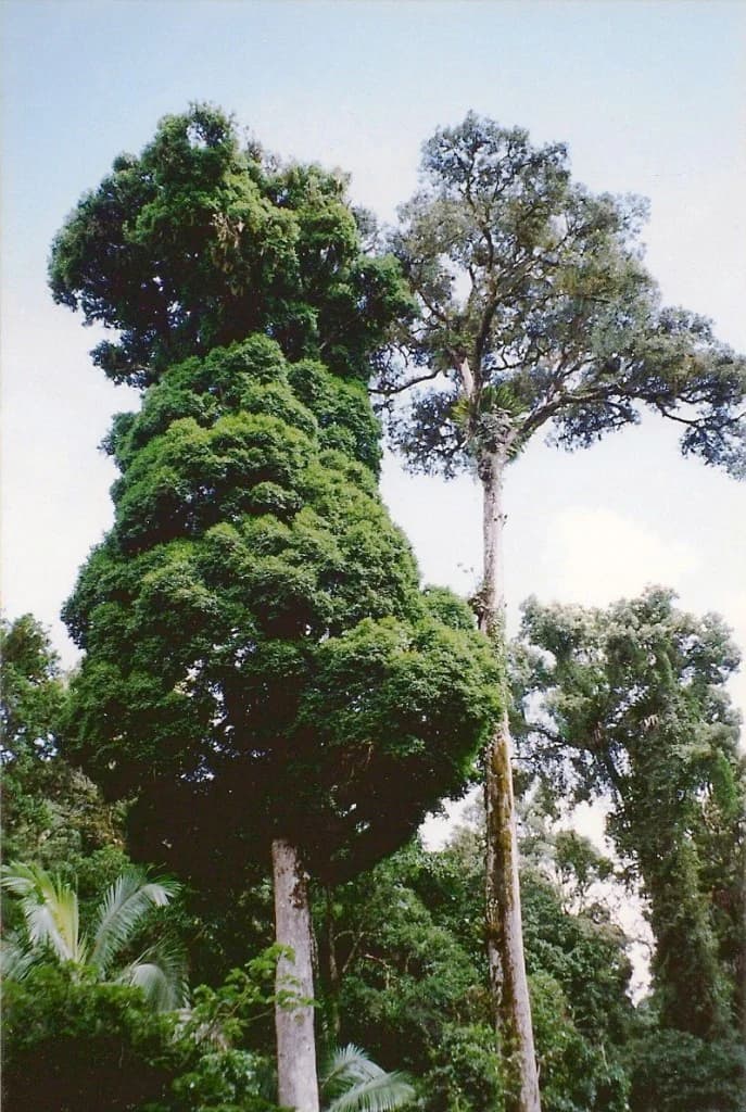
The terrain varies considerably across the park, from the wet, sheltered valleys where the subtropical rainforests thrive, to the drier, cooler ridges and slopes where eucalypt woodlands predominate. The Murray Scrub represents one of the most significant rainforest areas, featuring a dense canopy of ancient trees, including the black and white booyong and giant Syzygium species that can reach forty metres in height. The park's elevation range and aspect create diverse microclimates, resulting in an incredible diversity of flora from the tall gum forests of the lower slopes to the specialized rainforest communities of the sheltered gullies.

Toonumbar National Park flora
Syzygium francisii and Argyrodendron trifoliolatum trees in Toonumbar National Park.

Toonumbar National Park ecosystems, habitats, and plant life

The ecological character of Toonumbar National Park is defined by the convergence of subtropical and temperate rainforest communities within a relatively limited area. The park lies within the Gondwana Rainforests of Australia World Heritage Site, recognized for representing the surviving remnants of the forests that covered the ancient supercontinent Gondwana approximately 180 million years ago. These ancient lineages have survived in Australia due to the continent's geological stability and the presence of moist refugia during periods of climatic drying.

The combination of high annual rainfall, exceeding one metre per year with a recorded maximum of 449.4 millimetres in a single day, and fertile volcanic soils creates ideal conditions for rainforest development. The park supports a continuum of vegetation types from the subtropical rainforests of the valleys and lower slopes, through mixed eucalypt forests, to the tall gum woodlands of the higher ground. Bangalow palms are a distinctive feature of the park's forest understory, while the canopy includes species of Argyrodendron and Syzygium that can attain impressive heights. This vegetation diversity supports a corresponding richness of wildlife, with the rainforest areas serving as critical refuge for species that depend on these increasingly rare habitat types.

Toonumbar National Park, Murray Scrub, January 1995
Murray Scrub area within Toonumbar National Park, New South Wales, Australia.

Toonumbar National Park wildlife and species highlights

Toonumbar National Park provides crucial habitat for a range of threatened and significant wildlife species. The rainforest communities support populations of the sooty owl, a large nocturnal raptor that depends on old-growth forest for nesting, and the red-legged pademelon, a small marsupial that forages in the forest understory. The yellow-bellied glider, a marsupial that glids between trees using a membrane of skin, is also found within the park's forests.

The park is home to the Albert lyrebird, one of Australia's most remarkable bird species, known for its extraordinary ability to mimic the calls of other birds and mechanical sounds. The marbled frogmouth, a nocturnal bird related to the nightjars, inhabits the rainforest canopy. Koalas are present throughout the park, particularly in the eucalypt woodlands where they feed on the leaves of various gum species. The park's reptile fauna includes carpet pythons, while the amphibian community features numerous frog species that breed in the rainforest streams and pools. Fruit-eating pigeons and insectivorous bats are particularly associated with the rainforest areas, which provide important feeding and roosting habitat.

Toonumbar National Park conservation status and protection priorities

Toonumbar National Park represents a significant conservation achievement in the protection of Australia's ancient rainforest heritage. As part of the Gondwana Rainforests of Australia World Heritage Site, the park is recognized internationally for its outstanding universal value as a living record of the continent's evolutionary history. The World Heritage listing, originally inscribed in 1986 and reinforced by addition to the Australian National Heritage List in 2007, reflects the global significance of the park's ecosystems and the species they support.

The park protects some of the last remaining substantial tracts of subtropical rainforest in northern New South Wales, a region that has experienced extensive land clearing for agriculture and development. These rainforests serve as critical habitat for numerous threatened species, including the sooty owl, red-legged pademelon, and yellow-bellied glider. The successful Githabul Nation native title claim over the park area adds another dimension to its conservation framework, recognizing the importance of Aboriginal cultural connection to Country in contemporary protected area management.

Toonumbar National Park cultural meaning and human context

Toonumbar National Park holds profound cultural significance for the Githabul Nation, the Traditional Custodians of this landscape. The successful native title claim by the Githabul Nation represents a significant recognition of Aboriginal connection to Country and ongoing relationship with the land. The park contains numerous sites of cultural importance, including the jurabihls, or increase sites, that were documented in 1974 and are of National significance due to their rarity in Australia and worldwide.

Dome Mountain serves as the Githabul sacred site for the rain ceremony, reflecting the deep spiritual connection between the Traditional Custodians and the landscape's natural cycles. Edinburgh Castle is identified as the Goanna site, with cultural connections to the Clara Williams descendants who reside at the Aboriginal Reservation Muli Muli, located ten kilometres west of Woodenbong. The rugged landscape of Mount Lindesay, Dome Mountain, and Edinburgh Castle has provided the inspiration for many local Aboriginal legends, linking the physical geography of the park to cultural narratives that have been passed down through generations. The legal recognition of native title over the park area represents an important development in the relationship between Aboriginal people and protected area management in New South Wales.

Top sights and standout views in Toonumbar National Park

Toonumbar National Park offers visitors the opportunity to experience some of Australia's most ancient and ecologically significant rainforests. The Murray Scrub and Dome Mountain Forest areas provide outstanding examples of subtropical and temperate rainforest within the Gondwana Rainforest World Heritage Site. The park's volcanic landscape, with its dramatic peaks and steep ridges, creates a scenic backdrop for bushwalking and nature observation. The presence of threatened species including the sooty owl, yellow-bellied glider, and Albert lyrebird makes the park particularly significant for wildlife enthusiasts and researchers. The successful native title claim by the Githabul Nation adds cultural depth to the visitor experience, connecting the natural landscape to ongoing Aboriginal cultural traditions and spiritual practices.

Best time to visit Toonumbar National Park

The park can be visited throughout the year, though the warmer months from spring to autumn typically offer more comfortable conditions for outdoor activities. The subtropical climate means that rainfall can occur at any time, with the region receiving approximately 1,036 millimetres annually. The high rainfall contributes to the park's lush appearance but can result in track closures or difficult conditions after heavy storms. The winter months from June to August generally bring drier weather and cooler temperatures, making this a popular time for bushwalking. Visitors planning extended trips should check current conditions with the NSW National Parks and Wildlife Service, as weather patterns can vary and some tracks may be affected by seasonal conditions.

Park location guide

Geography guide, regional context, and park location map for Toonumbar National Park

Toonumbar National Park park geography, regions, and map view in Australia
Understand where Toonumbar National Park sits in Australia through a broader geographic reading of the surrounding landscape, nearby location context, and its mapped position within the national park landscape.

How Toonumbar National Park fits into Australia

Australia is a constitutional monarchy and federal parliamentary democracy comprising six states and ten territories. With a population of nearly 28 million, it is one of the world's most urbanised countries, with most people concentrated on the eastern seaboard. The country has a high Human Development Index and is known for its cultural diversity, ancient Aboriginal heritage, and unique wildlife.

Wider geography shaping Toonumbar National Park in Australia

Australia occupies the entire Australian continent, the island of Tasmania, and numerous smaller islands. It is the world's flattest and driest inhabited continent, featuring vast deserts in the interior (the Outback), tropical rainforests along the eastern coast, and a coastline bordering the Indian and Pacific Oceans.

Map view of Toonumbar National Park

Use this park location map to pinpoint Toonumbar National Park in Australia, understand its exact geographic position, and read its mapped placement within the surrounding landscape more clearly.

Pigeon | © OpenStreetMap contributors

Location context for Toonumbar National Park

New South Wales

Witness the striking scenery, ancient rainforest habitats, and rugged geological formations that define this protected landscape.

Toonumbar National Park Photos: Explore Ancient Rainforests and Volcanic Landscapes
Visually explore the unique natural environment of Toonumbar National Park, encompassing its ancient Gondwana Rainforests, dramatic volcanic remnants, and rich biodiversity. These protected area images offer essential insights into the park's distinct ecological character, helping to illustrate its varied landscapes and critical habitats within New South Wales.

Argyrodendron actinophyllum and trifoliolatum trees, Toonumbar National Park

Carpet Python Meal

Toonumbar National Park flora

Toonumbar National Park, Murray Scrub, January 1995

Park atlas

Explore surrounding landscapes and compare protected areas across the diverse Northern Rivers region of New South Wales.

Discover More National Parks and Protected Areas Near Toonumbar National Park, Australia
Browse other national parks and protected areas in the vicinity of Toonumbar National Park, mapping diverse landscapes including ancient Gondwana rainforests and distinctive volcanic terrain. Expanding your search beyond this specific location helps trace the regional spread of conservation efforts and compare ecological features across connected protected landscapes.
National parkNew South Wales

Mount Clunie National Park: Protected Mountain Landscape and Gondwana Rainforest Geography

Explore its mapped boundaries and regional significance.

Mount Clunie National Park is a protected national park in New South Wales, Australia, characterized by its mountainous terrain and its status as part of the Gondwana Rainforests of Australia World Heritage Site. Situated in the Scenic Rim region, the park's elevated position and ancient ecosystems offer unique insights into Australia's natural heritage. Understanding its geographic context and protected landscape identity provides essential context for regional atlas exploration.

Area
14.26 km²
Established
1999
IUCN
II
National parkNew South Wales

Koreelah National Park: Protected Landscape with Dramatic Gorges and Wildlife

Explore the mapped terrain and regional geography of this New South Wales national park.

Koreelah National Park is a protected national park located in northern New South Wales, Australia, celebrated for its rugged topography and significant natural features. The park's landscape is defined by spectacular gorges, sheer cliffs, and impressive waterfall systems, creating a remote wilderness experience. It serves as a vital protected area, offering refuge to diverse wildlife, including platypus and koalas, and is recognized for its importance within the Scenic Rim Important Bird Area. Discover its mapped boundaries and unique geographic context for a deeper understanding of Australian protected lands.

Area
53 km²
Established
1999
IUCN
II
National parkQueensland

Lamington National Park: Ancient Gondwanan Rainforests and Volcanic Terrain in Queensland

Mapped protected landscape with over 500 waterfalls and unique cloud forests.

Lamington National Park stands as a key protected area within Queensland, recognized for its world-heritage status Gondwanan rainforests and striking volcanic geography. The park's landscape is characterized by its ancient Antarctic beech forests, a legacy of millions of years of volcanic activity that sculpted dramatic cliffs, plateaus, and deep valleys, punctuated by more than 500 waterfalls. Through its mapped boundaries and detailed geographic context, users can explore the exceptional biodiversity and unique terrain that defines this significant Australian national park.

Area
206 km²
Established
1915
IUCN
II
National parkQueensland

Moogerah Peaks National Park: Protected Volcanic Peaks and Natural Terrain in Queensland

Explore mapped boundaries and regional landscape context.

Moogerah Peaks National Park represents a vital protected area in South East Queensland, safeguarding striking volcanic mountains and their unique ecosystems. This national park showcases dramatic cliff faces and distinct geological formations, offering a valuable snapshot of the region's natural heritage and landscape character. Understanding its protected status and geographic setting within Queensland enhances exploration of Australia's diverse natural environments.

Area
9.27 km²
Established
1982
IUCN
II
National parkNew South Wales

Mount Pikapene National Park: Protected Area with Tall Moist Rainforests in New South Wales

Explore the mapped terrain and regional geography of this national park.

Mount Pikapene National Park is a key protected area in New South Wales, recognized for its distinctive tall moist rainforests, a rare ecological community within the Northern Tablelands. The park's landscape features hilly terrain, with Big Sugarloaf marking its highest point at 525 meters. As a national park managed by the National Parks and Wildlife Service, it safeguards significant forest ecosystems and offers valuable insights into the protected geography of eastern Australia's natural heritage.

Area
26.3 km²
Established
1999
IUCN
II
National parkNew South Wales

Mount Jerusalem National Park: Ancient Volcanic Terrain and Protected Landscape Discovery in New South Wales

Explore its mapped geography and Albert's lyrebird habitat.

Mount Jerusalem National Park stands as a key protected area within the dramatic landscape of New South Wales. Situated on the eroded outer rim of the ancient Tweed Caldera, the park showcases distinctive volcanic terrain shaped over millions of years. Its protected boundaries encompass vital habitats, notably supporting significant populations of Albert's lyrebird, and contribute to the watershed dynamics of the Tweed, Brunswick, and Richmond River systems, offering a rich focus for geographic and landscape exploration.

Area
52 km²
Established
1995
IUCN
II
National parkQueensland

Tamborine National Park: Queensland's Accessible Rainforest and Waterfall Landscape

Explore unique plateau geography and mapped protected areas.

Tamborine National Park stands as a crucial protected area nestled atop the Tamborine Mountain plateau in South East Queensland. It preserves vital remnants of subtropical rainforest and eucalypt forests, presenting a rich tapestry of landscapes and biodiversity. The park's unique configuration, with its accessible walking tracks leading to waterfalls like Witches Falls, offers a remarkable opportunity to engage with a protected natural environment. This national park serves as an excellent resource for understanding regional geography and the importance of conservation within populated areas, featuring distinct terrain and mapped natural features.

Area
11.6 km²
Established
1993
IUCN
II
National parkNew South Wales

Broadwater National Park: Protected Coastal Wilderness and Geographic Atlas Entry

Coastal rainforest, wetlands, migratory bird habitats, and unique geology.

Broadwater National Park presents a rich protected-area identity within New South Wales, Australia, characterized by its diverse mosaic of coastal rainforests, freshwater swamps, and eucalyptus woodlands. This national park is notable for its unique Coffee Rocks geological formation and its crucial role as a refuge for migratory birds, offering a compelling focus for geographic exploration and atlas-based understanding. Discover the mapped extent and ecological significance of this significant protected landscape.

Area
421 km²
Established
1974
IUCN
II

Common questions about visiting, size, designation, and location context for Toonumbar National Park

Toonumbar National Park FAQs for park facts, access, geography, and protected area context
Find quick answers about Toonumbar National Park, including protected-area facts, park geography, trail and visitor context, and how the park fits into its surrounding country and regional landscape.
MoriAtlas Explorer

Continue Your Protected Areas Search Across the Global Atlas

Deepen your exploration by continuing the structured search for national parks and protected areas worldwide. Utilize the comprehensive filtering capabilities to compare different conservation landscapes and refine your understanding of global park geography. Discover more about the distribution and characteristics of protected natural areas.

Global natural geography