Mori Atlas logo
National parkWhitsunday Islands National Park

Discover mapped island geography, coastal landscapes, and protected marine park boundaries.

Whitsunday Islands National Park: Australia's Iconic Tropical Archipelago National Park in Queensland

Whitsunday Islands National Park represents a spectacular protected archipelago of 74 islands nestled off the coast of Queensland, Australia. This national park showcases a defining tropical island landscape, famed for its pure white silica beaches, dramatic headlands, and sheltered bays. Situated within the Great Barrier Reef Marine ecosystem, the park offers unparalleled opportunities to explore island geography, coastal terrain, and the unique mapped boundaries of this significant protected marine area.

Island national parkTropical islandsGreat Barrier ReefWhite sand beachesMarine protected areaWhale watching

Whitsunday Islands National Park

National park

Park overview

Structured park overview, official facts, and landscape profile for Whitsunday Islands National Park

Whitsunday Islands National Park park facts, protected area profile, and essential visitor context
Review the core facts for Whitsunday Islands National Park, including designation, size, terrain, visitor scale, habitats, and operating context in one park-focused overview.

About Whitsunday Islands National Park

Whitsunday Islands National Park represents a protected area of exceptional natural beauty and ecological significance within Queensland's coastal park network. The park encompasses a diverse archipelago lying midway along the Queensland coast, where the waters of the Coral Sea meet the southern reaches of the Great Barrier Reef. Each of the 74 islands within the park is surrounded by reef systems that form part of the Great Barrier Reef World Heritage Area, creating a seamless integration of terrestrial and marine protected values.

The park's landscape character is defined by rugged granite and sandstone headlands, Pocket forests of paperback and Eucalyptus species on larger islands, and the spectacular white sand beaches that have become synonymous with the Whitsunday name. Whitsunday Island, the largest in the group, features the renowned Whitehaven Beach stretching six kilometres along its eastern shoreline, with camping and picnic facilities available in the foredune areas. A walking track connects Whitehaven Beach to Chance Bay, providing visitors with opportunities to explore the island's interior landscapes.

The marine environment surrounding the islands supports extraordinary biodiversity, with coral reefs, seagrass beds, and deep water channels hosting numerous fish species, marine mammals, and invertebrates. The park's water temperatures and sheltered bay environments make it particularly significant as a seasonal habitat for migrating humpback whales, which congregate in the Whitsunday waters between May and September to calve and nurse their young. This annual whale presence adds a dynamic wildlife dimension to the park's already rich ecological character.

Access to the park is exclusively via water, with visitors arriving by private or commercial vessels from the coastal townships of Airlie Beach and Shute Harbour on the mainland. This water-based access model has helped preserve the islands' relatively undeveloped character, as no road infrastructure connects the islands to the mainland. The park receives significant visitation throughout the year, with peak periods coinciding with the dry season months and the whale calving season.

Quick facts and research context for Whitsunday Islands National Park

The park covers approximately 170 square kilometres across 74 islands, with Whitsunday Island being the largest and most visited. The park was formally established in 1944 and is managed by the Queensland Parks and Wildlife Service. The islands are situated within the traditional homelands of the Ngaro, Gia, and Juru peoples, whose sea country encompasses the archipelago and surrounding waters. The Great Barrier Reef surrounds all 74 islands, with only eight currently inhabited. Access is exclusively by boat from the mainland, with the primary departure points being Airlie Beach and Shute Harbour.

Park context

Deeper park guide and search-rich context for Whitsunday Islands National Park

Whitsunday Islands National Park history, landscape, wildlife, and travel context
Explore Whitsunday Islands National Park through its history, landscape character, ecosystems, wildlife, conservation priorities, cultural context, and seasonal travel timing in a structured park guide built for atlas discovery and search intent.

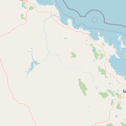
Why Whitsunday Islands National Park stands out

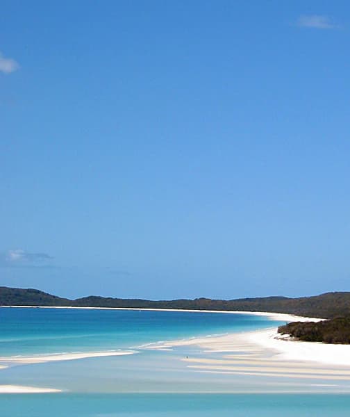
Whitsunday Islands National Park is best known for Whitehaven Beach on Whitsunday Island, a seven-kilometre stretch of pure white silica sand consistently ranked among the world's finest beaches. The park's iconic status also derives from its setting within the Great Barrier Reef marine ecosystem, with coral reefs encircling every island in the group. The archipelago serves as a significant seasonal habitat for humpback whales, which use the sheltered waters as a calving ground from May through September each year. The combination of island topography, beach aesthetics, reef-supported marine biodiversity, and accessible wilderness has made this national park one of Australia's most recognizable protected landscapes.

White sandy beach with turquoise water, distant hills under clear blue sky
Whitehaven Beach in Whitsunday Islands National Park with turquoise waters and white sand

Whitsunday Islands National Park history and protected-area timeline

Whitsunday Islands National Park was formally established in 1944, representing one of the earliest national park designations in Queensland's protected area system. The establishment of the park reflected growing recognition of the islands' natural values and the need to protect their distinctive landscapes from development pressures that had begun to emerge along the Queensland coast during the mid-twentieth century.

The park's creation also acknowledged the cultural significance of the islands to their traditional Aboriginal owners. The Whitsunday Islands and surrounding waters fall within the traditional sea country of the Ngaro, Gia, and Juru peoples, who maintain ongoing cultural connections to these landscapes and waters. The recognition of Aboriginal peoples as traditional owners and custodians of the coastal and marine environments has become increasingly integrated into the park's management approach, reflecting broader evolutions in protected area management philosophy across Australia.

Since establishment, the park has been managed by the Queensland Parks and Wildlife Service, which continues to oversee visitor access, conservation programs, and infrastructure maintenance across the island group. The development of visitor facilities at key locations such as Whitehaven Beach has been undertaken with attention to minimizing environmental impact while providing appropriate public access to this iconic landscape. The park's governance framework has evolved to address contemporary conservation challenges including marine ecosystem protection, visitor management, and climate change adaptation.

Whitsunday Islands National Park landscape and geographic character

The Whitsunday Islands present a distinctive tropical island landscape defined by granite and metamorphic rock formations, coastal cliffs, pocket forests, and exceptional beach environments. The islands lie within a transitional zone between the Coral Sea continental shelf and the Great Barrier Reef complex, creating a landscape where mountain island topography meets coral reef marine environments. The largest islands feature hilly terrain rising from sea level to summits exceeding 400 metres, with exposed rock outcrops and steep coastal slopes characteristic of the archipelago's visual character.

Whitehaven Beach stands as the park's most celebrated landscape feature, a six-kilometre crescent of pure white silica sand on the eastern coast of Whitsunday Island. The beach's exceptional whiteness derives from the silica content of the sand, which has been naturally processed by wave action over geological time. Behind the beach, foredune systems support specialized beach dune vegetation, while the island's interior contains dry sclerophyll forest communities adapted to the islands' seasonal rainfall patterns.

Hill Inlet, located at the northern end of Whitehaven Beach, creates a dramatic meeting point where tidal flows and sand movements produce constantly shifting patterns of white sand and turquoise water. This landscape feature exemplifies the dynamic coastal processes that shape the Whitsunday island environment. The surrounding waters range from shallow reef flat environments to deeper channels exceeding 20 metres, creating diverse marine and coastal landscapes that extend from the beach strand to the reef edge.

Whitsunday Islands National Park ecosystems, habitats, and plant life

The Whitsunday Islands support a range of terrestrial and marine ecosystems that reflect the archipelago's position within the Great Barrier Reef region. Terrestrial vegetation across the larger islands includes dry sclerophyll forest communities dominated by paperback and bloodwood Eucalyptus species, with vine thicket patches occurring in more sheltered localities. Coastal dune vegetation species occupy the beach foredune environments, while cliff-face communities adapted to salt spray and exposed conditions occur along rocky headlands.

The marine environment surrounding the islands constitutes one of the most biodiverse coastal ecosystems in Australia. Coral reef communities thrive in the clear waters surrounding each island, with reef flat, reef slope, and lagoon environments providing habitat for numerous coral species and associated fish communities. Seagrass meadows occur in shallower protected bays, supporting dugong populations and providing important feeding grounds for marine turtles. The transition from island terrestrial environments through nearshore reef systems to deeper water channels creates a complex ecological mosaic that supports high biological productivity.

The park's position within the Great Barrier Reef World Heritage Area connects its marine ecosystems to the broader reef system that stretches over 2,300 kilometres along the Queensland coast. Water quality within the park benefits from the reef system's natural filtration capacity, while the islands provide important roosting and nesting sites for seabirds and shorebirds. The combination of terrestrial biodiversity, reef-associated marine life, and the seasonal presence of migratory marine mammals creates an ecological profile of considerable significance.

Whitsunday Islands National Park wildlife and species highlights

The Whitsunday Islands provide habitat for diverse wildlife communities spanning terrestrial, coastal, and marine environments. Among the most significant seasonal visitors are humpback whales, which migrate to the sheltered waters of the Whitsunday archipelago between May and September each year to give birth and nurse their calves. These whale populations have recovered from historical commercial hunting pressure and now form a significant component of the park's wildlife experience, with boat-based whale watching opportunities available during the migration season.

Marine turtles, including green turtles and hawksbill turtles, frequent the reef waters surrounding the islands and nest on beach sites across the archipelago. Dugong, a protected marine mammal species, graze on seagrass beds in shallower bay areas. The reef environments support numerous fish species, including coral trout, parrotfish, and trevally, while larger pelagic species including reef sharks and manta rays occur in deeper waters adjacent to the reef edges.

Terrestrial wildlife includes various bird species such as white-bellied sea-eagles and ospreys that nest on cliff faces, while bush stone-curlews and ground-dwelling birds inhabit the island forests. The islands support populations of spectacled flying-foxes, which roost in forest patches and provide important seed-dispersal functions. The combination of island-based terrestrial wildlife and reef-associated marine species creates a wildlife profile of considerable diversity, though the park is perhaps most celebrated for its marine megafauna and seasonal whale presence.

Whitsunday Islands National Park conservation status and protection priorities

Whitsunday Islands National Park sits within the Great Barrier Reef World Heritage Area, one of the world's most significant marine protected landscapes. The park's conservation significance derives from the integration of island terrestrial ecosystems with surrounding coral reef environments, creating a protected area that encompasses both terrestrial and marine biodiversity values. The Great Barrier Reef's World Heritage listing acknowledges the outstanding universal value of this marine ecosystem, within which the Whitsunday Islands play a significant role.

The park contributes to conservation of several threatened and migratory species, including humpback whales that use the Whitsunday waters as a seasonal calving ground. Marine turtle populations benefit from protection of nesting beaches and foraging habitats within the park boundaries. The reef systems surrounding each island provide protected habitat for coral reef biodiversity, though these environments face ongoing pressures from climate change, ocean acidification, and crown-of-thorns starfish outbreaks that affect reef health across the Great Barrier Reef region.

Management by the Queensland Parks and Wildlife Service focuses on maintaining ecological integrity while providing sustainable visitor access to the islands. Visitor impact management, marine water quality protection, and fire management on larger islands form key components of the conservation program. The park's island setting provides some natural protection from mainland development pressures, though climate change impacts including sea-level rise and altered storm patterns present emerging challenges for long-term conservation planning.

Whitsunday Islands National Park cultural meaning and human context

The Whitsunday Islands and surrounding waters lie within the traditional sea country of the Ngaro, Gia, and Juru Aboriginal peoples, whose connections to these landscapes extend across thousands of years. These Aboriginal groups maintained sophisticated maritime cultures that encompassed extensive use of the island environments, navigation of the waters between islands, and sustainable harvesting of marine resources. The islands and surrounding seas hold cultural significance that is reflected in traditional knowledge systems, place names, and ongoing cultural practices.

Historical documentation of Aboriginal connections to the Whitsunday Islands was significantly advanced through the work of Dorothy Turnbull, an early chronicler of the region's Indigenous heritage who recorded place names and traditional knowledge associated with the islands during the early twentieth century. This work contributed to understanding the deep cultural connections that Aboriginal peoples maintained with these coastal and island environments prior to and following European settlement of the Queensland coast.

Contemporary park management acknowledges the ongoing cultural connections of traditional owner groups to the Whitsunday Islands and incorporates Aboriginal cultural values into conservation planning and visitor interpretation. The integration of Indigenous knowledge and cultural perspectives into park management reflects evolving approaches to protected area governance across Queensland and Australia more broadly, recognizing that cultural and natural values are interconnected in the management of these island landscapes.

Top sights and standout views in Whitsunday Islands National Park

Whitehaven Beach stands as the undisputed highlight of Whitsunday Islands National Park, its six kilometres of pure white silica sand creating one of the world's most photogenic beach environments. Hill Inlet at the beach's northern end provides a constantly shifting landscape where tidal flows create intricate patterns of white sand and turquoise water. The opportunity to camp overnight on Whitsunday Island adjacent to Whitehaven Beach offers a backcountry experience rarely available at such an iconic location, accessible only by boat from the mainland. The seasonal presence of humpback whales between May and September creates extraordinary wildlife viewing opportunities, with mother whales and newborn calves frequently observed in the protected waters surrounding the islands. The Great Barrier Reef setting provides exceptional snorkeling and diving experiences directly from island beaches, with coral reef environments accessible within swimming distance of the shore.

Best time to visit Whitsunday Islands National Park

The optimal time to visit Whitsunday Islands National Park depends on the experiences sought, with distinct seasonal patterns affecting wildlife viewing, marine conditions, and overall visitor comfort. The dry season from May through October offers generally stable weather conditions, lower humidity, and reduced rainfall, making this the most popular time for island visitation. This period coincides with the humpback whale migration season, providing excellent opportunities to observe whales in the park's waters between May and September, with peak whale activity typically occurring during the winter months of June through August.

The warmer months from November through April bring higher temperatures and increased humidity, along with the wet season rains that can affect marine visibility around the islands. This period also coincides with the marine stinger season, when box jellyfish and Irukandji jellyfish are present in island waters between October and May. Most visitors choose to wear stinger suits when swimming during this period. Despite the marine stinger presence, the summer months offer excellent conditions for reef activities, with warmer water temperatures making extended snorkeling more comfortable. The shoulder seasons of April-May and October-November often provide favorable conditions combining good weather with reduced visitor numbers.

Park location guide

Geography guide, regional context, and park location map for Whitsunday Islands National Park

Whitsunday Islands National Park park geography, regions, and map view in Australia
Understand where Whitsunday Islands National Park sits in Australia through a broader geographic reading of the surrounding landscape, nearby location context, and its mapped position within the national park landscape.

How Whitsunday Islands National Park fits into Australia

Australia is a constitutional monarchy and federal parliamentary democracy comprising six states and ten territories. With a population of nearly 28 million, it is one of the world's most urbanised countries, with most people concentrated on the eastern seaboard. The country has a high Human Development Index and is known for its cultural diversity, ancient Aboriginal heritage, and unique wildlife.

Wider geography shaping Whitsunday Islands National Park in Australia

Australia occupies the entire Australian continent, the island of Tasmania, and numerous smaller islands. It is the world's flattest and driest inhabited continent, featuring vast deserts in the interior (the Outback), tropical rainforests along the eastern coast, and a coastline bordering the Indian and Pacific Oceans.

Map view of Whitsunday Islands National Park

Use this park location map to pinpoint Whitsunday Islands National Park in Australia, understand its exact geographic position, and read its mapped placement within the surrounding landscape more clearly.

Pigeon | © OpenStreetMap contributors

Location context for Whitsunday Islands National Park

Queensland

Visualizing Queensland's Tropical Archipelago: Terrain, Coastal Habitats, and Reef Environments

Whitsunday Islands National Park Photos: Explore Iconic Landscapes and Protected Area Scenery
Explore a comprehensive visual gallery of Whitsunday Islands National Park, revealing its stunning white silica beaches, distinctive island topography, and diverse coastal ecosystems. The photography offers critical insight into the park's protected landscapes and vibrant marine environments, enhancing your understanding of this iconic Queensland destination.

White sandy beach with turquoise water, distant hills under clear blue sky

Blue sign for Whitsunday Islands National Park with white text and icons, located on white sand beach with trees and vegetation in background

Park atlas

Compare coastal, island, and marine protected landscapes across the Queensland region

Discover National Parks and Protected Areas Near Whitsunday Islands National Park
After exploring Whitsunday Islands National Park, browse other protected areas, island national parks, and marine reserves found throughout coastal Queensland and the Great Barrier Reef region. This regional view offers geographic context, allowing you to trace connected protected landscapes and compare diverse conservation efforts across similar tropical island and marine environments.
National parkQueensland

Conway National Park: Queensland National Park Geographic Exploration and Protected Landscape

Mapped boundaries and regional natural terrain of this Australian national park.

Delve into Conway National Park, a key protected area situated in Queensland, Australia. This national park offers rich geographic discovery, allowing for detailed exploration of its mapped landscape and protected boundaries. Understand its role within the broader atlas of Australian natural regions, appreciating its specific landscape characteristics and its contribution to the regional geography of northeastern Australia.

Area
225 km²
Established
1938
IUCN
II
Relief
Lowland
National parkQueensland

Molle Islands National Park: Queensland National Park Atlas and Protected Landscape Identity

Mapped boundaries and regional geographic context within northeastern Australia.

Molle Islands National Park is a designated national park located in Queensland, Australia. This dedicated atlas entry provides an understanding of its protected landscape character, focusing on its mapped geographic boundaries and its position within the regional context of northeastern Australia. Explore how this protected area contributes to the broader understanding of Queensland's natural geography and conservation lands.

Area
18 km²
IUCN
II
Climate
Tropical
Access
Moderate access
National parkQueensland

Dryander National Park: Queensland's Protected Landscape and Geographic Identity

Mapped boundaries and natural terrain context in Queensland.

Delve into the protected landscape of Dryander National Park, a significant national park located in Queensland, Australia. This entry provides essential geographic context, detailing the park's boundaries and its representation within the broader regional atlas of protected areas. Understand its role as a mapped natural landscape contributing to the unique geography of Queensland, ideal for detailed exploration without travel logistics.

Area
118.82 km²
Established
1938
IUCN
II
Relief
Mountain
National parkQueensland

Gloucester Island National Park: A National Park within Queensland's Diverse Geography

Mapped protected area and natural landscape context.

Gloucester Island National Park represents a distinct protected landscape in Queensland, Australia. This entry focuses on its identity as a national park, providing atlas-level detail on its geographic scope and mapped boundaries. Understand how this protected area fits within the broader natural terrain and regional geography of northeastern Australia, offering a unique lens for map-based exploration and discovery.

Area
29.6 km²
Established
1994
IUCN
II
Relief
Lowland
National parkQueensland

Lindeman Islands National Park: Queensland National Park Atlas and Protected Landscape

Explore mapped boundaries and regional geography within Queensland.

Lindeman Islands National Park is a designated national park offering insights into Queensland's protected natural landscapes. This page provides an atlas-style exploration of its geographic scope, mapped terrain, and role as a protected area within the northeastern Australian region. Understand its setting and unique landscape character for informed geographic discovery.

Area
33.1 km²
IUCN
II
Relief
Lowland
Climate
Tropical
National parkQueensland

Repulse Island National Park: Queensland's Coastal Protected Area and Mapped Geography

Explore this key national park's mapped boundaries and island landscape.

Repulse Island National Park is an important protected natural area offering unique insights into coastal island geography within Queensland's expansive conservation network. Established as a national park, it signifies a commitment to preserving representative natural landscapes. This page focuses on the mapped boundaries, regional geographic context, and the protected landscape identity of Repulse Island National Park, providing a detailed entry point for atlas-driven discovery of Australia's protected areas.

Area
1.51 km²
Established
1994
IUCN
II
Scope
Terrestrial
National parkQueensland

Smith Islands National Park: Queensland Coastal Protected Area Map

Discover the mapped geography and island landscapes of North Queensland.

Smith Islands National Park represents a significant protected island landscape off the coast of Queensland, Australia. This page allows for detailed exploration of its geographic features, mapped boundaries, and role as a national park within the North Queensland region's atlas of natural areas. Understand the unique character of these tropical islands and their place within Australia's network of preserved coastal environments.

Area
18.7 km²
IUCN
II
Scope
Terrestrial
National parkQueensland

Holbourne Island National Park: Queensland Coastal Wildlife Sanctuary and Maritime Atlas Entry

Explore the mapped geography and protected landscape of this small island national park.

Holbourne Island National Park, situated off the Queensland coast, serves as a vital protected area focused on coastal wildlife conservation. This 34-hectare national park is recognized for its importance as a natural bird sanctuary and a critical nesting ground for sea turtles, offering a focused point of discovery for marine ecosystem protection. Its landscape, characterized by coastal vegetation and rock formations, also holds a unique maritime history, notably tied to the SS Gothenburg shipwreck, making it a compelling destination for understanding Australia's island protected areas and their regional geographic context within the Coral Sea.

Area
0.34 km²
Established
1982
IUCN
II
Relief
Lowland

Common questions about visiting, size, designation, and location context for Whitsunday Islands National Park

Whitsunday Islands National Park FAQs for park facts, access, geography, and protected area context
Find quick answers about Whitsunday Islands National Park, including protected-area facts, park geography, trail and visitor context, and how the park fits into its surrounding country and regional landscape.
MoriAtlas Explorer

Continue Your Protected Areas Search Across the Global Atlas

Deepen your exploration by continuing the structured search for national parks and protected areas worldwide. Utilize the comprehensive filtering capabilities to compare different conservation landscapes and refine your understanding of global park geography. Discover more about the distribution and characteristics of protected natural areas.

Global natural geography