Mori Atlas logo
National parkNiumi National Park

Discover the mapped boundaries and diverse delta geography of this vital Gambian national park.

Niumi National Park: Gambia's Premier Protected Coastal Wetland and Mangrove Landscape

Niumi National Park represents a significant protected coastal landscape in The Gambia, recognized for its vital role within the transboundary Sine-Saloum Delta. This national park showcases a rich mosaic of wetland habitats, dominated by extensive Rhizophora mangrove forests that thrive along tidal channels and intricate lagoon systems. Its designation as a Ramsar site underscores its international importance as a critical area for migratory waterbirds and a key component of West Africa's coastal conservation efforts, offering users a unique lens into regional protected-area geography.

coastal wetlandsmangrove forestsbirdwatchingRamsar siteWest Africadelta ecosystem

Niumi National Park

National park

Park overview

Structured park overview, official facts, and landscape profile for Niumi National Park

Niumi National Park park facts, protected area profile, and essential visitor context
Review the core facts for Niumi National Park, including designation, size, terrain, visitor scale, habitats, and operating context in one park-focused overview.

About Niumi National Park

Niumi National Park represents a critical protected area within The Gambia's coastal zone, safeguarding a substantial portion of the country's involvement in the Sine-Saloum Delta, a vast ecological complex that extends across the Gambia-Senegal border. The park's coastal position at the mouth of the delta creates a dynamic environment where tidal influences, freshwater outflows, and ocean processes interact to produce a rich tapestry of habitats. The dominance of Rhizophora mangrove forests throughout the park's wetland areas provides essential ecosystem services including coastal protection, carbon storage, and nursery functions for fish and crustacean species. Beyond the mangroves, the park includes freshwater marsh zones, brackish lagoon systems, and exposed sand spits that add ecological and visual variety to the protected landscape. Jinack Island, located in the northern reaches of the park, supports scrub forest vegetation that contrasts with the surrounding wetland environments, creating additional habitat diversity. The park's designation as a Ramsar site in 2008 reflects its international significance as a wetland ecosystem, while its Important Bird Area status acknowledges the critical role it plays in supporting populations of terns and gulls during non-breeding seasons.

Quick facts and research context for Niumi National Park

Niumi National Park is situated along the Atlantic coast in The Gambia's North Bank Region, at the southern terminus of the Sine-Saloum Delta. The protected area spans roughly 4,940 hectares of coastal terrain and was formally established in 1987 as The Gambia's portion of the delta's wetland system. The park features a transitional landscape where freshwater river systems meet the Atlantic Ocean, creating a complex ecological interface of mangroves, mudflats, islands, and coastal dunes. Jinack Island and numerous smaller islands punctuate the northern section of the park, adding to its topographical diversity. The wetland complex supports over 200 bird species and has been recognized as an Important Bird Area by BirdLife International.

Park context

Deeper park guide and search-rich context for Niumi National Park

Niumi National Park history, landscape, wildlife, and travel context
Explore Niumi National Park through its history, landscape character, ecosystems, wildlife, conservation priorities, cultural context, and seasonal travel timing in a structured park guide built for atlas discovery and search intent.

Why Niumi National Park stands out

Niumi National Park is best known for its extensive Rhizophora mangrove forests, which form one of the most dense and ecologically significant coastal forest complexes in The Gambia. The park's mudflats and swamp areas serve as critical staging and wintering grounds for significant populations of terns, including slender-billed gulls, Caspian terns, sandwich terns, royal terns, and roseate terns. The coastal and marine environments within and adjacent to the park provide habitat for vulnerable species including green sea turtles, humpback dolphins, West African manatees, and red colobus monkeys. The combination of mangroves, islands, and wetland habitats makes this a key site for coastal conservation in West Africa.

Niumi National Park history and protected-area timeline

Niumi National Park was established in 1987 as The Gambia's formal protection of its portion of the Sine-Saloum Delta, a coastal wetland system that had long been recognized for its ecological importance. The delta had already been the subject of conservation consideration in the years prior to formal park establishment, with The Gambia declaring its portion of the delta as a national park in 1986. The subsequent designation in 1987 formalized the protected status and provided a framework for ongoing management of the coastal wetland resources. The park's significance was further elevated when it was designated as a Ramsar Wetland of International Importance on October 13, 2008, placing it within the global network of wetlands protected under the Ramsar Convention. This international recognition acknowledged the park's role as a habitat for migratory birds and its representation of a vulnerable coastal wetland ecosystem type.

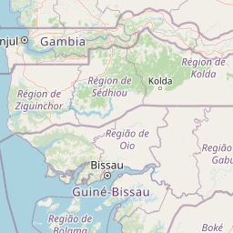
Niumi National Park landscape and geographic character

The landscape of Niumi National Park is defined by its position at the interface between the Sine-Saloum Delta's freshwater and brackish wetland systems and the Atlantic Ocean. The terrain consists primarily of low-lying coastal wetlands interspersed with elevated sand deposits, islands, and lagoon systems. Rhizophora mangrove forests dominate the wetland areas, forming dense, interconnected canopies along tidal channels and across mudflat zones. The park includes extensive mudflats that are exposed at low tide and submerged during higher water levels, creating a dynamic coastal environment. Jinack Island rises slightly above the surrounding wetlands and supports scrub forest vegetation rather than mangroves, providing topographic and vegetative contrast within the park. Sand spits extend along sections of the coastline, adding exposed beach and dune character to the otherwise wetland-dominated landscape. The numerous small islands scattered throughout the northern portion of the park add further landscape complexity and create varied habitats for nesting birds and resting marine species.

Niumi National Park ecosystems, habitats, and plant life

The ecological character of Niumi National Park is shaped by its position within the Western Africa Marine ecoregion and its function as a coastal wetland transition zone. The park encompasses a range of wetland types from freshwater marsh in interior zones to brackish lagoons and tidal mudflats near the coast. Rhizophora mangrove forest represents the most extensive vegetation type, forming nearly continuous coverage across the park's wetland areas and providing critical habitat structure for numerous species. The scrub forest found on Jinack Island and Mbankam spit represents a distinct habitat type, supporting different plant communities than the mangrove-dominated wetlands. The interface between wetland and marine environments creates productive ecological zones where species from both systems interact. The park's position within a transboundary delta system means it functions as part of a larger ecological unit that supports regional biodiversity patterns across national boundaries.

Niumi National Park wildlife and species highlights

Niumi National Park supports a notable assemblage of wildlife, particularly within its marine and wetland environments. The bird fauna is especially significant, with over 200 species recorded within the park boundaries. The wetland mudflats and coastal waters provide critical habitat for tern populations, with the park designated as an Important Bird Area because it supports significant non-breeding and wintering populations of slender-billed gulls, Caspian terns, sandwich terns, and royal terns. Roseate terns are also common visitors along the Atlantic coast sections of the park. Among the park's mammalian residents, several vulnerable species occur including red colobus monkeys, West African manatees, and humpback dolphins that utilize the coastal waters. The terrestrial mammal community includes patas monkeys, vervet monkeys, spotted hyenas, and warthogs, particularly in the forested areas around Jinack Island. Green sea turtles visit the coastal waters and beaches, representing another vulnerable species that depends on the park's marine environments.

Niumi National Park conservation status and protection priorities

Niumi National Park holds significant conservation value as a protected coastal wetland within the Western Africa Marine ecoregion. The park's Ramsar designation since 2008 recognizes its international importance as a wetland habitat, particularly for migratory waterbirds that rely on the mudflats and coastal waters during their non-breeding seasons. The park's mangrove forests provide important ecosystem services including coastal protection, carbon sequestration, and water quality maintenance, while also serving as nursery areas for fish and crustacean species that support local fisheries. The presence of multiple vulnerable species including green sea turtles, West African manatees, humpback dolphins, and red colobus monkeys indicates the park's importance as a refuge for threatened fauna. The designation as an Important Bird Area by BirdLife International further underscores the site's significance for bird conservation, particularly for tern species that gather in significant numbers during wintering periods.

Niumi National Park cultural meaning and human context

Niumi National Park is located in a region where local communities have historically maintained connections to the delta's resources, though the specific indigenous or traditional cultural context for this particular protected area is not extensively documented in available source material. The park's landscape has been shaped by natural coastal processes and the delta's hydrological dynamics rather than by prominent cultural heritage features. The communities in the surrounding region engage with the broader delta ecosystem for fishing and resource use, though precise details about traditional land management practices within the current park boundaries are limited in the source material.

Top sights and standout views in Niumi National Park

Niumi National Park stands out for its extensive mangrove forests that create a distinctive green coastal landscape within The Gambia. The park's importance as a bird sanctuary is highlighted by the presence of multiple tern species and the designation as an Important Bird Area, with large flocks of slender-billed gulls, Caspian terns, sandwich terns, and royal terns using the wetlands seasonally. The diversity of wetland habitats from mangroves to mudflats to freshwater marshes creates ecological variety within a relatively compact protected area. The presence of vulnerable marine species including green sea turtles, humpback dolphins, and West African manatees adds further conservation significance. The transboundary context with the Sine-Saloum Delta extending into Senegal positions this park as part of a larger regional conservation landscape.

Best time to visit Niumi National Park

Niumi National Park can be visited throughout the year, though the optimal period for birdwatching coincides with the dry season when migratory terns and gulls are present in significant numbers. The winter months from November through March typically see the highest concentrations of non-breeding waterbirds in the wetland areas. The wet season from June to October brings higher water levels that may affect access to some wetland zones but also creates lush green conditions across the park. Coastal conditions are generally most stable during the dry season when tidal patterns are more predictable and boat access to mangroves and islands is easier.

Park location guide

Geography guide, regional context, and park location map for Niumi National Park

Niumi National Park park geography, regions, and map view in Gambia
Understand where Niumi National Park sits in Gambia through a broader geographic reading of the surrounding landscape, nearby location context, and its mapped position within the national park landscape.

How Niumi National Park fits into Gambia

The Gambia is a small West African nation located along the Gambia River, which flows from east to west and empties into the Atlantic Ocean. It is the smallest country in continental Africa by area and is almost entirely surrounded by Senegal. The country gained independence from Britain in 1965 and operates as a unitary presidential republic with Banjul as its capital.

Wider geography shaping Niumi National Park in Gambia

The Gambia occupies a narrow strip of land along the Gambia River in West Africa. The country spans approximately 11,300 km² and is almost completely surrounded by Senegal, with only a short Atlantic coastline in the west. The terrain is generally flat with floodplains along the river.

Map view of Niumi National Park

Use this park location map to pinpoint Niumi National Park in Gambia, understand its exact geographic position, and read its mapped placement within the surrounding landscape more clearly.

Pigeon | © OpenStreetMap contributors

Location context for Niumi National Park

North Bank Region
Park atlas

Browse the Mapped Geography and Connected Protected Landscapes of the Greater Sine-Saloum Delta Region and West African Coastline

Explore Other National Parks Near Niumi National Park, The Gambia, and Broader West African Coastal Protected Areas
Expand beyond Niumi National Park to explore nearby protected areas, including coastal wetlands and mangrove forests across The Gambia and the greater Sine-Saloum Delta ecosystem. Compare these diverse conservation landscapes and their unique geographic contexts, identifying interconnected habitats and significant bird areas within the broader West African region.
National parkGambia

Tanji Bird Reserve National Park: Coastal Wetlands and Avian Diversity in Gambia

Explore unique geography and protected landscape boundaries.

Tanji Bird Reserve National Park showcases a distinctive coastal landscape where the Atlantic Ocean meets lagoons, dry woodland, and dune scrub. This 612-hectare protected area in The Gambia is celebrated for its incredible birdlife, with nearly 300 species recorded, including significant Palearctic migrants and the nation's sole breeding seabird colonies on the Bijol Islands. The reserve offers a rich context for understanding West African protected areas, mapped terrain, and coastal ecosystem geography.

Area
6.12 km²
Established
1993
IUCN
II
Wildlife reserveGambia

Bao Bolong Wetland Reserve: West African Wildlife Reserve with Extensive Mangrove Ecosystems

Explore mapped terrain and crucial protected wetland boundaries.

Bao Bolong Wetland Reserve in Gambia is a significant protected area renowned for its ecological importance as a Ramsar wetland and Important Bird Area. This wildlife reserve features the tallest mangrove trees in the Senegambia region, transitioning through salt marshes to savanna, all centered around the Bao Bolong tributary's estuary. Its complex hydrological network and diverse habitats support 268 bird species and are crucial for the endangered West African manatee, offering a rich landscape for geographic and protected-area discovery.

Area
220 km²
Established
1996
IUCN
VI
National parkMali

Bafing National Park: Mali National Park Atlas and Protected Woodland Landscape

Explore the unique chimpanzee habitat and bird conservation within this West African savanna.

Bafing National Park is a cornerstone of conservation in Mali, recognized for its exclusive role in protecting chimpanzee populations within the Manding Plateau region. This extensive national park features a predominant woodland ecosystem interspersed with savanna areas, providing critical habitat for numerous bird species as designated by BirdLife International. Understanding Bafing National Park's mapped geography and protected landscape offers insight into vital primate and avian conservation efforts in West Africa.

Area
5,000 km²
Established
2000
IUCN
II
National parkFaranah Region

National Park of Upper Niger: Protected Landscape and Geographic Context in Faranah Region

Explore mapped boundaries and regional natural terrain.

National Park of Upper Niger is a key protected area within the Faranah Region of Guinea, providing a focal point for understanding regional geography and conservation landscapes. Its designation as a national park highlights its importance in the mapped atlas of protected territories. This page offers detailed insights into the park's geographic setting and its specific natural terrain, aiding exploration of Guinea's protected lands.

Area
6,000 km²
Established
1997
IUCN
II
Relief
Mixed relief
Protected areaCabo Verde

Fogo Natural Park Protected Area: Mapped Volcanic Terrain and Endemic Landscapes of Cabo Verde

Explore the unique geography of an active volcano and its island conservation context.

Fogo Natural Park offers a focused study of volcanic terrain and island protected-area dynamics within Cabo Verde. The park centers on Pico do Fogo, an active stratovolcano, showcasing dramatic caldera features and unique endemic plant life found nowhere else. Understanding Fogo Natural Park through its mapped boundaries and distinct geological context is key to appreciating the island's natural heritage and conservation significance.

Area
84.69 km²
Established
2003
IUCN
II
Relief
Mountain
National parkEastern Province

Gola Rainforest National Park: Sierra Leone's Premier Rainforest Protected Area

Explore mapped boundaries and biodiversity in Eastern Province's vast tropical rainforest.

Gola Rainforest National Park is Sierra Leone's second national park and the largest intact rainforest landscape in the country, located in the Eastern Province. As part of the Upper Guinea Forest biodiversity hotspot, it is renowned for its exceptional wildlife, including western chimpanzees and pygmy hippopotamuses. This protected area's mapped extent covers over 71,000 hectares, contributing significantly to regional conservation and providing a vital natural resource for both wildlife and local communities.

Area
710.7 km²
Established
2010
IUCN
II
Relief
Lowland
Protected areaNimba County

Nimba National Forest: Protected Mountain Landscape & Bird Area in Nimba County

Explore mapped boundaries and regional geographic context.

Nimba National Forest, a protected area of approximately 187 square kilometers, is defined by its mountainous terrain in Nimba County, Liberia. Situated at the tri-border region with Guinea and Ivory Coast, this forest is recognized for its importance as a habitat for diverse bird species and its role in regional conservation efforts. Discover its mapped landscape, its position within the Nimba Range, and its ecological significance within West Africa's protected natural areas.

Area
187 km²
IUCN
VI
Protected areaNimba County

Gibi National Forest: Protected Tropical Forest in Nimba County, Liberia

Mapped landscape and regional geography of this key conservation area.

Gibi National Forest, a protected tropical forest spanning 607 square kilometers in Nimba County, Liberia, plays a crucial role in the preservation of the Upper Guinea forest ecosystem. Established in 1960, its landscape features tropical forest terrain near the mountainous Nimba Range. This protected area contributes significantly to regional conservation strategies, offering a vital habitat within a biodiversity hotspot that faces considerable pressure.

Area
607 km²
Established
1960
IUCN
VI
Climate
Tropical

Common questions about visiting, size, designation, and location context for Niumi National Park

Niumi National Park FAQs for park facts, access, geography, and protected area context
Find quick answers about Niumi National Park, including protected-area facts, park geography, trail and visitor context, and how the park fits into its surrounding country and regional landscape.
MoriAtlas Explorer

Continue Your Protected Areas Search Across the Global Atlas

Deepen your exploration by continuing the structured search for national parks and protected areas worldwide. Utilize the comprehensive filtering capabilities to compare different conservation landscapes and refine your understanding of global park geography. Discover more about the distribution and characteristics of protected natural areas.

Global natural geography