Mori Atlas logo
National parkPhrumsengla National Park

Explore unique altitudinal zones and temperate forest ecosystems across its mapped boundaries.

Phrumsengla National Park: Bhutan's Protected Landscape in the Himalayan Atlas

Phrumsengla National Park represents a significant protected landscape in the heart of Bhutan's Himalayas. This national park spans dramatic elevation gradients from subtropical valleys to alpine meadows, encompassing approximately 905 square kilometres. Its position along the Lateral Road offers unique access to observe its diverse terrain, from old-growth fir forests to fragile alpine environments, providing crucial context for understanding the park's geography and its role within the broader national park atlas.

National ParkHimalayasOld-growth ForestTemperate ForestBird ConservationSnow Leopard Habitat

Phrumsengla National Park

National park

Park overview

Structured park overview, official facts, and landscape profile for Phrumsengla National Park

Phrumsengla National Park park facts, protected area profile, and essential visitor context
Review the core facts for Phrumsengla National Park, including designation, size, terrain, visitor scale, habitats, and operating context in one park-focused overview.

About Phrumsengla National Park

Phrumsengla National Park represents one of Bhutan's principal protected areas, established to safeguard the ecological integrity of central Himalayan forests and the diverse species they support. The park's location in the foothills of the Himalayas positions it at a critical intersection of biogeographic zones, where sub-tropical forest gives way to temperate woodland and eventually alpine conditions as elevation increases. The park's establishment in 1998 reflected Bhutan's broader commitment to maintaining at least 60% of its land area under forest cover, with national parks forming the cornerstone of this environmental strategy. The Lateral Road that traverses the park is not only a vital transportation link connecting eastern and western Bhutan but also provides a unique opportunity for visitors to experience the park's landscapes directly, though this accessibility also presents management challenges related to balancing tourism with conservation objectives. The presence of approximately 11,000 residents within the park boundaries illustrates the complex reality of protected area management in mountainous regions where human communities have long maintained connections to the landscape.

Quick facts and research context for Phrumsengla National Park

Phrumsengla National Park covers 905.05 square kilometres in central Bhutan, protecting temperate Himalayan ecosystems across Bumthang, Lhuntse, Mongar, and Zhemgang districts. The park was established in 1998 under the management of the Royal Government of Bhutan, with the Bhutan Trust Fund for Environmental Conservation serving as a key institutional partner. Its elevation range of 700 to 4,400 metres supports diverse habitats including old-growth forests, fir-dominated woodland, and alpine zones. The Lateral Road, Bhutan's highest motorable highway, passes through the park, providing access while also creating a transportation corridor through the protected landscape.

Park context

Deeper park guide and search-rich context for Phrumsengla National Park

Phrumsengla National Park history, landscape, wildlife, and travel context
Explore Phrumsengla National Park through its history, landscape character, ecosystems, wildlife, conservation priorities, cultural context, and seasonal travel timing in a structured park guide built for atlas discovery and search intent.

Why Phrumsengla National Park stands out

Phrumsengla National Park is especially known for its exceptional avifauna, protecting several threatened bird species within its temperate forest habitats. The park shelters the rufous-necked hornbill, satyr tragopan, beautiful nuthatch, Ward's trogon, rufous-throated wren-babbler, and chestnut-breasted partridge, making it a significant site for Himalayan bird conservation. The park also supports populations of large mammals including the snow leopard in its high-altitude zones, as well as Asian elephants, Indian rhinoceros, and wild water buffalo in lower elevations. Its extensive old-growth and fir forests, combined with the dramatic altitudinal range from subtropical valleys to alpine peaks, create a particularly varied protected landscape within the Himalayan region.

Phrumsengla National Park history and protected-area timeline

Phrumsengla National Park was officially established in 1998, representing a formalized recognition of the ecological significance of the Thrumshing La region in central Bhutan. The park was originally designated under the name Thrumshingla National Park but was subsequently renamed to reflect the more widely used spelling of Phrumsengla, aligning with local usage and official Dzongkha transliteration conventions. The protected area was created as part of Bhutan's systematic expansion of its national park network during the late 1990s, a period when the kingdom was consolidating its approach to biodiversity conservation and sustainable land management. The Bhutan Trust Fund for Environmental Conservation has played a central role in supporting park management and funding conservation initiatives within the protected area. The park's boundaries were drawn to encompass portions of four districts, recognizing that the ecological and watershed functions of the Thrumshing La area extended beyond any single administrative division.

Phrumsengla National Park landscape and geographic character

The physical landscape of Phrumsengla National Park is defined by its position in the Himalayan foothills, where elevation changes create dramatic transitions in terrain and scenery across relatively short distances. The park spans altitudes from approximately 700 metres in its lower valleys to 4,400 metres in its alpine zones, with the Thrumshing La pass serving as a distinctive high point within the protected area. The terrain includes steep mountain slopes, forested ridges, and valley bottoms carved by streams descending from higher elevations. The old-growth forests that characterize lower and middle elevations are dominated by fir species, creating dense canopy coverage across substantial portions of the park. Soils in the park are recognized as particularly fragile, a characteristic that has influenced management decisions regarding development activities and has reinforced the rationale for maintaining these areas under protection. The landscape changes substantially with season, as monsoonal rainfall transforms valley streams and the appearance of the forest changes across the year.

Phrumsengla National Park ecosystems, habitats, and plant life

The ecological character of Phrumsengla National Park reflects its position within a globally significant biodiversity hotspot, with the park protecting representative samples of Himalayan temperate forest ecosystems. The park's altitudinal range supports multiple distinct ecological zones, from sub-tropical forest at lower elevations through temperate broadleaf and coniferous forest to alpine meadows and rocky terrain at the highest points. The extensive old-growth forests represent increasingly rare examples of unmodified Himalayan woodland, providing habitat for species that depend on mature forest structure and the ecological continuity it provides. Fir forests dominate substantial portions of the park, creating the visual and ecological backbone of the protected landscape. The fragility of soils throughout the park has contributed to its preservation, as the terrain is considered unsuitable for logging or agricultural development, leaving large areas in natural condition. This ecological integrity has been maintained despite the presence of human communities within the park boundaries.

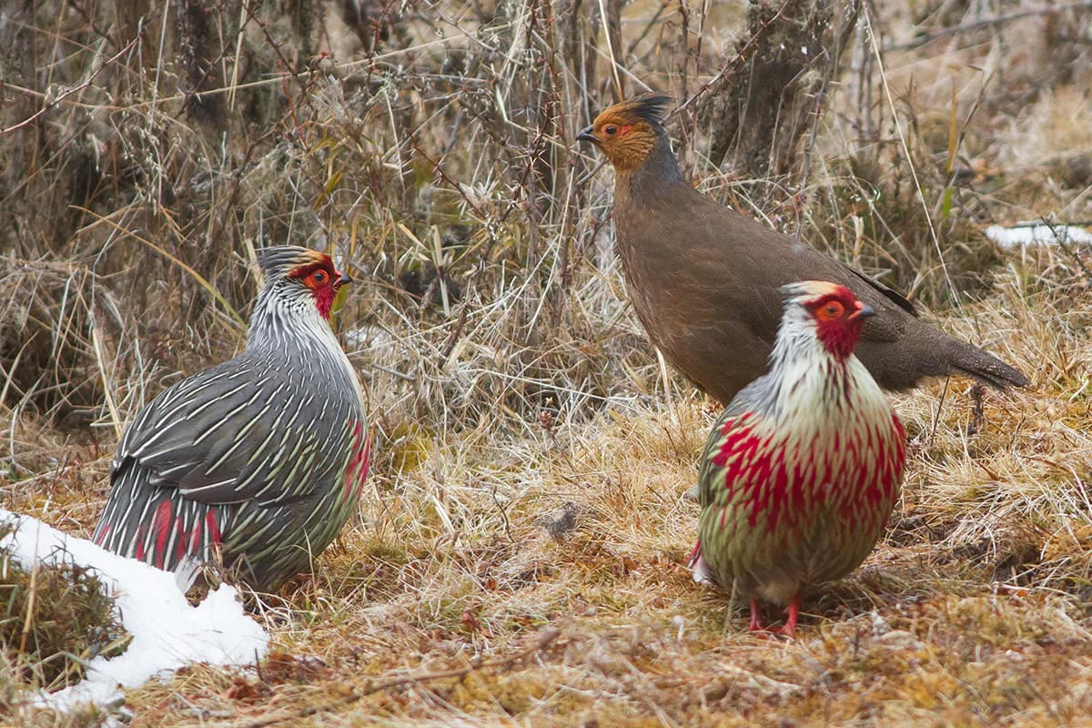
Phrumsengla National Park wildlife and species highlights

Phrumsengla National Park supports a remarkable diversity of wildlife, with particular significance attached to its bird species and large mammals. The park provides critical habitat for six threatened bird species: the rufous-necked hornbill, rufous-throroated wren-babbler, satyr tragopan, beautiful nuthatch, Ward's trogon, and chestnut-breasted partridge. The near-threatened wedge-billed wren babbler also occurs within the park. Mammalian fauna includes significant populations of large herbivores such as Asian elephants, Indian rhinoceros, and wild water buffalo, with the park representing an important area for these species within Bhutan. Smaller ungulates include the barasingha, Himalayan goral, hog deer, mainland serow, and northern red muntjac. The high-altitude zones provide habitat for the elusive snow leopard, while primate species including Assamese macaque, rhesus macaque, capped langur, and Gee's golden langur occur in forested areas. Carnivores present include dholes, Eurasian and smooth-coated otters, leopard cats, and yellow-throated marten. The rodent and shrew diversity is particularly notable, with numerous species recorded.

Phrumsengla National Park conservation status and protection priorities

Phrumsengla National Park holds significant conservation value within Bhutan's protected area network and contributes to broader regional and global biodiversity protection efforts. The park's IUCN designation as Category II reflects its primary purpose of protecting natural ecosystems while allowing for sustainable visitor use. Several species occurring within the park are classified as threatened under international conservation frameworks, making the protected area strategically important for their survival. The fragile soils and mountainous terrain that make development unsuitable have paradoxically contributed to habitat preservation, leaving large tracts of old-growth forest intact. The Bhutan Trust Fund for Environmental Conservation maintains active involvement in supporting park management and conservation programs. The World Wildlife Fund also maintains operations within the park, contributing additional capacity to conservation efforts. Nearly 11,000 residents within the park boundaries represent both a conservation challenge and an opportunity, as authorities have noted the park demonstrates relatively successful integration of human communities with natural resource protection.

Top sights and standout views in Phrumsengla National Park

Phrumsengla National Park offers exceptional Himalayan nature experiences through its combination of accessible landscapes along Bhutan's principal east-west highway, diverse forest ecosystems spanning dramatic elevation changes, and populations of threatened species including the snow leopard and rufous-necked hornbill. The park's bisection by the Lateral Road provides unique opportunities for visitors to traverse high-altitude terrain while observing temperate forest transitions. The old-growth fir forests represent particularly valuable examples of Himalayan forest ecosystems that remain relatively unmodified. Birdwatchers find significant interest in the park's threatened species, while the presence of large mammals including elephants and rhinoceros in lower elevations adds to wildlife viewing potential.

Best time to visit Phrumsengla National Park

Phrumsengla National Park can be visited throughout the year, though the experience varies substantially with seasonal conditions. The autumn months from September through November typically offer clear skies and stable weather, making this period popular for wildlife viewing and landscape appreciation. Winter months bring colder temperatures, particularly at higher elevations, but can provide opportunities for observing wildlife at lower elevations where animals congregate near available forage. The monsoon season from June through September brings heavy rainfall to the region, creating lush forest conditions but potentially affecting travel along the Lateral Road. Spring provides another favorable period for visiting, with moderate temperatures and the possibility of observing flowering vegetation in the forests. Visitors traveling along the Lateral Road should be aware that weather conditions in mountain passes can change rapidly regardless of season.

Park location guide

Geography guide, regional context, and park location map for Phrumsengla National Park

Phrumsengla National Park park geography, regions, and map view in Bhutan
Understand where Phrumsengla National Park sits in Bhutan through a broader geographic reading of the surrounding landscape, nearby location context, and its mapped position within the national park landscape.

How Phrumsengla National Park fits into Bhutan

Bhutan, officially the Kingdom of Bhutan, is a landlocked country in South Asia situated in the Eastern Himalayas. With a population of approximately 727,000 and an area of 38,394 km², it is a constitutional monarchy ruled by the Wangchuck dynasty. The country is known for its Gross National Happiness philosophy, pristine mountain landscapes, and commitment to preserving its Buddhist culture.

Wider geography shaping Phrumsengla National Park in Bhutan

Bhutan is located in the Eastern Himalayas in South Asia, bordered by China to the north and northwest and India to the south and southeast. The country's terrain is predominantly mountainous with steep valleys, ranging from elevations around 100 meters in the southern foothills to peaks exceeding 7,000 meters in the northern highlands. The major river systems flow southward from the Himalayas into India's Brahmaputra basin.

Map view of Phrumsengla National Park

Use this park location map to pinpoint Phrumsengla National Park in Bhutan, understand its exact geographic position, and read its mapped placement within the surrounding landscape more clearly.

Pigeon | © OpenStreetMap contributors

Location context for Phrumsengla National Park

Bumthang DistrictLhuntse DistrictMongar DistrictZhemgang District
Park atlas

Compare national park geography and protected landscapes within Bhutan's Eastern Himalayas.

Discover More National Parks Near Phrumsengla National Park, Bhutan, and Explore Related Himalayan Protected Areas
Continue exploring national parks and protected areas across Bhutan, expanding your geographic understanding beyond Phrumsengla National Park's distinct Himalayan ecosystems. Compare the regional spread of protected landscapes, trace diverse conservation zones, and identify additional areas of interest within this significant mountainous region.
Wildlife reserveTrashigang District

Sakteng Wildlife Sanctuary: Protected Area and Wildlife Reserve in Bhutan's Trashigang District

Mapping the mountainous terrain and unique temperate ecosystems.

Sakteng Wildlife Sanctuary is a vital protected area in eastern Bhutan, recognized as a wildlife reserve. Spanning approximately 742 square kilometers within Trashigang District, it features a dramatic mountainous terrain characterized by steep valleys and alpine meadows. The sanctuary's landscape transitions from forested slopes to subalpine conifer forests, representing Bhutan's easternmost temperate ecosystems and offering rich geographic context for atlas exploration.

Area
742.46 km²
Established
2003
IUCN
IV
Wildlife reserveBhutan

Phibsoo Wildlife Sanctuary: Bhutan's Wildlife Reserve Atlas and Geographic Identity

Mapping the protected landscape and natural terrain of this Bhutanese sanctuary.

Delve into the specifics of Phibsoo Wildlife Sanctuary, a protected wildlife reserve situated within the geographic expanse of Bhutan. This park detail page focuses on its identity as a conservation landscape, offering insights into its mapped terrain and its significance within the broader regional geography of the Eastern Himalayas. Understand the protected boundaries and the unique natural context that Phibsoo Wildlife Sanctuary represents.

Area
268.93 km²
Established
2009
IUCN
IV
Wildlife reserveBhutan

Motithang Takin Preserve: Bhutan Wildlife Reserve with Unique Protected Landscape Context

Explore the mapped geography and national animal sanctuary.

The Motithang Takin Preserve offers a unique glimpse into Bhutan's dedication to its national animal, the takin. This wildlife reserve, located near the capital city, provides a defined protected area where the distinctive goat-antelope thrives. By examining the preserve's mapped boundaries and its forested terrain, users gain insight into Bhutan's approach to conservation and the cultural significance of this iconic species within the Himalayan landscape.

Area
0.034 km²
IUCN
IV
National parkBhutan

Jigme Dorji National Park: Bhutan's Vast Protected Landscape and Himalayan Geography

Explore mapped boundaries and diverse ecosystems within this national park.

Jigme Dorji National Park, located in the heart of Bhutan, is a testament to the country's commitment to conservation, covering over 4,300 square kilometers of pristine Himalayan terrain. This national park encompasses diverse ecosystems, from lush subtropical forests in its lower reaches to barren alpine meadows and permanent snowfields at its highest elevations. The park's extensive mapped boundaries showcase a landscape vital for unique wildlife and sacred cultural sites, offering a comprehensive view for atlas-based geographic discovery.

Area
4,316 km²
Established
1974
IUCN
II
Relief
Mountain
National parkAssam

Orang National Park: Assam's Key Floodplain Protected Landscape

Explore mapped boundaries and terrain context of this national park.

Orang National Park, located in Assam, India, is a significant protected area celebrated for its unique alluvial floodplain terrain and critical role in conservation. This national park provides a focused atlas-style view of grassland and wetland ecosystems, essential habitats for iconic species like the great Indian one-horned rhinoceros and Bengal tiger. Its geographical setting along the Brahmaputra River contributes to a dynamic landscape, offering rich context for understanding protected area distribution and regional natural features. Discover the mapped boundaries and ecological significance of this important protected land.

Area
78.81 km²
Established
1985
IUCN
II
Relief
Lowland
National parkAlipurduar district

Jaldapara National Park: India's Premier Grassland and Rhino Conservation Landscape

Explore mapped boundaries and savanna terrain in Alipurduar district.

Jaldapara National Park is a protected national park in India's Alipurduar district, celebrated for its expansive rolling grasslands and significant population of Indian one-horned rhinoceros. This protected area showcases a distinctive savanna landscape, an unusual feature among Indian national parks, interspersed with riverine forests. Its elevation of 61 meters above sea level positions it at the edge of the Eastern Himalayas, offering a unique geographic setting for understanding regional biodiversity and conservation efforts.

Area
216.51 km²
Established
2014
IUCN
II
National parkWest Garo Hills district

Nokrek National Park: Protected Mountain Landscape and Regional Geography

Explore its mapped boundaries and diverse natural terrain.

Nokrek National Park is a vital protected mountain wilderness situated in the West Garo Hills district, Meghalaya, India. Its rugged terrain, characterized by ancient geological formations and dense evergreen forests, supports remarkable biodiversity. As a key component of the Nokrek Biosphere Reserve, it offers a unique glimpse into the region's ecological significance, serving as an important source for major rivers and a sanctuary for diverse flora and fauna.

Area
47.48 km²
Established
1986
IUCN
II
Relief
Mountain
National parkDarjeeling District

Singalila National Park: A High-Altitude Protected Landscape on the Eastern Himalayan Ridge

Explore mapped terrain and alpine park geography in Darjeeling District.

Singalila National Park represents a crucial protected natural landscape within the Eastern Himalayas, located in India's Darjeeling District. Defined by its dramatic ridgeline that ascends to over 4,000 meters, the park offers a unique alpine environment with stunning panoramic views. Its designation as a national park highlights its importance for conservation and its role in the regional geographic atlas. Discover the mapped boundaries and ecological context of this remarkable mountain wilderness, from its dense forests to its open alpine meadows.

Area
78.6 km²
Established
1986
IUCN
II

Common questions about visiting, size, designation, and location context for Phrumsengla National Park

Phrumsengla National Park FAQs for park facts, access, geography, and protected area context
Find quick answers about Phrumsengla National Park, including protected-area facts, park geography, trail and visitor context, and how the park fits into its surrounding country and regional landscape.
MoriAtlas Explorer

Continue Your Protected Areas Search Across the Global Atlas

Deepen your exploration by continuing the structured search for national parks and protected areas worldwide. Utilize the comprehensive filtering capabilities to compare different conservation landscapes and refine your understanding of global park geography. Discover more about the distribution and characteristics of protected natural areas.

Global natural geography