Mori Atlas logo
National parkBái Tử Long National Park

Discover the mapped boundaries and geographic context of this unique Vietnamese national park.

Bái Tử Long National Park: Protected Island Archipelago & Marine Landscape Atlas

(Vườn quốc gia Bái Tử Long)

Bái Tử Long National Park represents a significant protected landscape in Vietnam's Quảng Ninh Province, featuring a distinctive archipelago of approximately 40 limestone islands and vital marine ecosystems. As one of the country's few national parks encompassing both terrestrial and marine environments, it offers a unique opportunity for atlas-based exploration of coastal karst geography and protected biodiversity. This park page provides detailed information on its geographic setting, mapped features, and the rich natural context of its islands and surrounding waters.

Coastal Protected AreaIsland Nature ReserveASEAN Heritage ParkMarine BiodiversityLimestone Karst LandscapeCoral Reef Protection

Bái Tử Long National Park

National park

Park overview

Structured park overview, official facts, and landscape profile for Bái Tử Long National Park

Bái Tử Long National Park park facts, protected area profile, and essential visitor context
Review the core facts for Bái Tử Long National Park, including designation, size, terrain, visitor scale, habitats, and operating context in one park-focused overview.

About Bái Tử Long National Park

Bái Tử Long National Park occupies a strategic position in northern Vietnam's coastal protection network, preserving the island and marine environments of Bái Tử Long Bay within Vân Đồn District. The park's territory encompasses three island groups scattered across coastal waters, creating a protected corridor that extends from forested island slopes through coastal fringe ecosystems into the productive marine zone below. This layered landscape structure means that the park protects not just visible land features but the entire ecological chain from hilltop to seafloor.

The park's location adjacent to Hạ Long Bay places it within one of Vietnam's most internationally recognized landscapes. While Hạ Long Bay receives the majority of visitor attention, Bái Tử Long offers a similar aesthetic of dramatic limestone formations rising from protected waters, but with its own distinct character and less intensive development pressure. The park's core zone spans three administrative communes (Minh Châu, Vạn Yên, and Hạ Long), while the buffer zone extends across five additional communes including Bản Sen and Quan Lạn. Approximately 24,000 people reside within the core and buffer zones, maintaining communities that exist in relationship with the protected landscape.

As one of seven national parks in Vietnam that protect both land and sea environments, Bái Tử Long serves as a model for integrated coastal zone management. The park's five distinct ecosystem types create a complex ecological mosaic: tropical rainforest on the islands, limestone forest communities on karst slopes, coastal vegetation zones, coral reef areas, and extensive shallow water environments. This diversity supports the park's designation as an ASEAN Heritage Park, which recognizes protected areas of regional significance that maintain ecological integrity, representativeness, and naturalness.

Quick facts and research context for Bái Tử Long National Park

Bái Tử Long National Park covers 157.83 square kilometers, comprising 61.25 square kilometers of islands and 96.58 square kilometers of marine waters, with an additional buffer zone of 165.34 square kilometers. Located in Vân Đồn special administrative region of Quảng Ninh Province, the park was established in 2001 based on the former Ba Mùn Nature Reserve and was designated an ASEAN Heritage Park in 2016. The park protects three island groups and surrounding marine environments within Bái Tử Long Bay, adjacent to the Hạ Long Bay World Heritage Site.

Park context

Deeper park guide and search-rich context for Bái Tử Long National Park

Bái Tử Long National Park history, landscape, wildlife, and travel context
Explore Bái Tử Long National Park through its history, landscape character, ecosystems, wildlife, conservation priorities, cultural context, and seasonal travel timing in a structured park guide built for atlas discovery and search intent.

Why Bái Tử Long National Park stands out

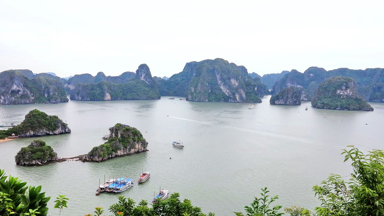
Bái Tử Long National Park is most distinctive for its combination of terrestrial and marine protection within a single park boundaries, a relatively rare feature among Vietnam's national parks. The park protects a remarkable island archipelago environment with approximately 40 islands and islets rising from productive marine waters. Its coral reef systems support at least 409 documented species, while the surrounding shallow waters harbor more than 539 species. The park's landscape of limestone islands and clear marine waters creates a visual continuity with the adjacent Hạ Long Bay, one of the world's most celebrated bay landscapes. The park's biodiversity includes rare and threatened species such as the limestone cycad (Cycas balansae), Indian pangolin, and various primate species.

Bái Tử Long National Park history and protected-area timeline

Bái Tử Long National Park was established on June 1, 2001 through Decision 85/2001/QĐ-TTg issued by the Prime Minister of Vietnam. The park was created on the foundation of the earlier Ba Mùn Nature Reserve, which had provided baseline protection for the area's natural values. This institutional evolution from a nature reserve to a national park reflected Vietnam's expanding commitment to comprehensive landscape protection that encompasses both terrestrial and marine environments.

The park's establishment marked an important milestone in Vietnam's protected area system, as it became one of only seven national parks in the country that protect both land and sea within a single management framework. This integrated approach recognized that the area's ecological value derived from the connection between island forests and the surrounding marine waters, rather than treating these as separate conservation concerns. In 2016, the park received additional recognition as an ASEAN Heritage Park, a designation that reflects regional appreciation for the park's ecological significance and its contribution to Southeast Asia's natural heritage.

Bái Tử Long National Park landscape and geographic character

The landscape of Bái Tử Long National Park is defined by its archipelago setting within Bái Tử Long Bay. Approximately 40 islands and islets are distributed across the park's marine territory, grouped into three distinct clusters: the Ba Mùn group, the Trà Ngọ group, and the Sậu group. These islands are predominantly limestone formations, characteristic of the karst landscape that dominates much of northern Vietnam's coastal zone. The limestone islands rise abruptly from the surrounding waters, with steep cliffs and slopes supporting forest vegetation despite the thin soils typical of karst terrain.

The marine component of the park encompasses waters between the islands and extending outward toward the mainland coast. Shallow marine zones surround the islands, creating conditions suitable for coral reef development and supporting productive fish communities. The transition from island slopes through coastal fringe to marine waters creates a visual landscape of remarkable variety, with the vertical contrast between towering karst peaks and the horizontal expanse of the sea. This landscape continues visually beyond the park boundaries to connect with the broader Hạ Long Bay system, one of the world's most iconic coastal karst landscapes.

Bái Tử Long National Park ecosystems, habitats, and plant life

Bái Tử Long National Park protects five primary ecosystem types that together create a diverse ecological landscape. The tropical rainforest ecosystem occurs on island slopes and represents largely secondary forest with canopy coverage ranging from 50 to 90 percent. This forest type supports approximately 494 animal and plant species, including several that are considered rare or threatened. Limestone forest ecosystems develop on the nutrient-poor soils of karst areas, hosting specialized species adapted to the challenging substrate conditions. Coastal ecosystems occupy the narrow zones surrounding islands where specialized mangrove and beach vegetation communities develop.

The marine ecosystems within the park include coral reef areas and shallow water zones. Coral reefs extend from the low-tide mark to depths of approximately 10 meters, supporting at least 409 documented species including groupers, snappers, crabs, mollusks, and sea cucumbers. The shallow water zone encompasses broader areas surrounding the islands, extending from the tidal zone outward to distances of 1 to 4 kilometers from shore. Although these deeper marine areas remain less thoroughly studied, research has already documented 539 species within these waters.

Bái Tử Long National Park wildlife and species highlights

The biodiversity of Bái Tử Long National Park reflects its diverse habitat mosaic. In the limestone forest areas, notable species include the limestone cycad (Cycas balansae), a primitive plant species of conservation concern, along with the Indian pangolin (Manis crassicaudata), civets including the common palm civet and large Indian civet, and various primate species such as the rhesus macaque (Macaca mulatta). The tropical rainforest supports additional species including the Owston's palm civet and other forest-dwelling mammals.

Marine wildlife within the park is particularly diverse, with the coral reef and shallow water ecosystems supporting numerous fish species, invertebrates, and marine organisms. The documented species include groupers and snappers among the fish, various crab species, numerous mollusk species including abalone, and diverse seaweed communities. The mangrove and coastal zones around the islands provide habitat for additional species adapted to the interface between land and sea. This marine biodiversity forms a significant component of the park's overall ecological value and supports the park's designation as an ASEAN Heritage Park.

Bái Tử Long National Park conservation status and protection priorities

Bái Tử Long National Park holds significant conservation importance within Vietnam's protected area network and the broader ASEAN region. Its designation as an ASEAN Heritage Park in 2016 recognized the park's ecological integrity, representativeness, naturalness, and conservation importance at a regional scale. The park's status as one of only seven national parks in Vietnam that protect both terrestrial and marine environments reflects the relatively rare combination of land and sea protection that the park provides.

The park contributes to regional biodiversity conservation by protecting a complex of five distinct ecosystem types within a contiguous protected landscape. The coral reef systems, while less extensively studied than some better-known reef areas, support a remarkable diversity of species and represent important marine habitat within the northern Vietnamese coastal zone. The forest ecosystems on the islands provide habitat for species with restricted distributions in the limestone karst environment. The park's location adjacent to the Hạ Long Bay World Heritage Site also creates a conservation corridor that supports the broader ecological functioning of this internationally recognized landscape.

Bái Tử Long National Park cultural meaning and human context

Bái Tử Long National Park exists within a landscape shaped by long-term human presence. The approximately 24,000 residents living within the park's core and buffer zones maintain communities with historical connections to the islands and surrounding waters. Fishing and associated maritime activities have traditionally supported local livelihoods, creating a relationship between human communities and the marine environment that the park now seeks to balance with conservation objectives.

Historical cultural elements within the park include temple sites dating to the Lý dynasty, an important period in Vietnamese history when the capital was established in the Hanoi region. These heritage features add cultural depth to the park's natural values, connecting the protected landscape to Vietnam's historical development. The park's location within Vân Đồn District also relates to the broader historical significance of the Quảng Ninh coastal region, which has served as a maritime gateway and fishing grounds for centuries.

Top sights and standout views in Bái Tử Long National Park

Bái Tử Long National Park offers a distinctive combination of protected island and marine environments in one of Vietnam's most scenic coastal regions. The park's approximately 40 islands create an archipelago setting with dramatic limestone formations rising from clear waters, similar in character to the adjacent Hạ Long Bay but with its own distinct identity. The park's coral reefs and marine waters support remarkable biodiversity, with more than 400 coral species and over 500 species documented in shallow waters. As one of seven national parks in Vietnam protecting both land and sea, it represents an integrated approach to coastal conservation. The park's ASEAN Heritage Park designation recognizes its regional significance, while its proximity to the Hạ Long Bay World Heritage Site places it within one of the world's most celebrated natural landscapes.

Best time to visit Bái Tử Long National Park

Bái Tử Long National Park can be visited throughout the year, though the optimal period generally spans from October through December when weather conditions are more stable and comfortable for outdoor activities. The winter months from November to February bring cooler temperatures and reduced rainfall, offering favorable conditions for hiking and exploration of the island landscapes. The summer months from May to September tend to be warmer and wetter, with increased precipitation and higher humidity affecting some visitor activities. Marine conditions vary seasonally, with water clarity generally better during the dry season months. Visitors interested in wildlife observation may find different species more active during different seasons, though the park's ecosystems remain accessible year-round.

Park location guide

Geography guide, regional context, and park location map for Bái Tử Long National Park

Bái Tử Long National Park park geography, regions, and map view in Vietnam
Understand where Bái Tử Long National Park sits in Vietnam through a broader geographic reading of the surrounding landscape, nearby location context, and its mapped position within the national park landscape.

How Bái Tử Long National Park fits into Vietnam

Vietnam, officially the Socialist Republic of Viet Nam, is a unitary communist state in Southeast Asia. It occupies roughly 331,000 square kilometres along the eastern edge of Mainland Southeast Asia, with a population exceeding 102 million. The country is bordered by China to the north, Laos and Cambodia to the west, and has maritime boundaries in the Gulf of Thailand and South China Sea.

Wider geography shaping Bái Tử Long National Park in Vietnam

Vietnam occupies the eastern edge of Mainland Southeast Asia, stretching along the Gulf of Thailand to the southwest and the South China Sea to the east. The country is bordered by China to the north, and Laos and Cambodia to the west. It has a diverse landscape ranging from the Red River Delta in the north to the Mekong Delta in the south.

Map view of Bái Tử Long National Park

Use this park location map to pinpoint Bái Tử Long National Park in Vietnam, understand its exact geographic position, and read its mapped placement within the surrounding landscape more clearly.

Pigeon | © OpenStreetMap contributors

Location context for Bái Tử Long National Park

Quảng Ninh Province
Park atlas

Map adjacent national parks and protected areas, comparing their distinct island, coastal, and marine landscapes in the region near Bái Tử Long National Park.

Discover More Protected Areas, National Parks, and Marine Reserves Near Bái Tử Long National Park
Browse a curated selection of national parks and protected areas situated near Bái Tử Long National Park, encompassing diverse coastal, island, and marine landscapes. Compare the geographic context, conservation priorities, and regional spread of protected territories across northern Vietnam, continuing your park discovery journey.
National parkVietnam

Cát Bà National Park: Vietnam's Critically Endangered Species Sanctuary & Karst Landscape

Mapped protected area with diverse terrestrial and marine ecosystems.

As a critical national park in Vietnam, Cát Bà National Park protects a remarkable limestone karst landscape central to the Hạ Long Bay region. This area is renowned for its steep peaks, narrow valleys, and coastal mangrove environments, supporting a uniquely diverse array of flora and fauna. Its status as a protected area highlights its global importance for conservation, particularly as the exclusive habitat of the Cát Bà langur. Explore the mapped geography and ecological significance of this vital Vietnamese protected land.

Area
152 km²
Established
1986
IUCN
II
National parkVĩnh Phúc Province

Tam Dao National Park: Vietnam's Mountain National Park and Biodiversity Hotspot

Explore mapped boundaries and regional landscape context.

Tam Dao National Park is a key protected area in northern Vietnam, defined by its rugged mountain terrain featuring over 20 peaks exceeding 1,000 meters. This national park is a vital habitat for diverse flora and fauna, including numerous endemic species, and showcases transitional forest ecosystems from tropical to montane zones. Understanding Tam Dao National Park involves exploring its geographic setting within Vĩnh Phúc Province and appreciating its role as a significant protected landscape.

Area
368.83 km²
Established
1996
IUCN
II
National parkHanoi

Ba Vì National Park: Ancient Volcanic Mountains and Protected Landscape Near Hanoi

Discover the mapped geography and biodiversity of this national park.

Ba Vì National Park, a protected natural area near Hanoi, showcases a dramatic landscape shaped by ancient volcanic activity. The park features three significant peaks, including Vua Mountain, creating a distinct topographical profile. Spanning over 10,800 hectares, it is recognized for its ecological diversity, harboring a wealth of plant and animal species. This national park serves as a vital protected landscape, offering a unique opportunity for geographic exploration and understanding the natural terrain surrounding the Vietnamese capital.

Area
108.15 km²
Established
1991
IUCN
II
Relief
Mountain
National parkPhú Thọ Province

Xuân Sơn National Park: Protected Mountain Landscape and Regional Geography

Mapping the southeastern edge of the Hoang Lien Mountains.

Delve into the protected landscape of Xuân Sơn National Park, a key national park situated in Phú Thọ Province, Vietnam. This area, covering about 150 square kilometers, is defined by its rugged mountainous terrain, featuring steep forested slopes and distinct ridgelines that contribute to the region's varied topography. As a protected national park, Xuân Sơn plays a crucial role in preserving the natural characteristics of the southeastern Hoang Lien Mountains. Its geographic setting is significant, acting as a transition zone between higher montane environments and the nearby lowland river systems, offering a unique perspective on Vietnam's diverse natural heritage.

Area
150.48 km²
Established
1986
IUCN
II
National parkVietnam

Phong Nha, Kẻ Bàng National Park: Vietnam's Karst Terrain and Subterranean World

Explore protected landscapes, cave systems, and geological wonders.

Phong Nha, Kẻ Bàng National Park in Vietnam is a globally significant protected landscape, recognized by UNESCO for its exceptional karst topography and extensive cave networks. This national park features dramatic limestone mountains, deep river gorges, and some of the world's most impressive subterranean formations, offering a rich atlas of natural history and geological wonders to explore.

Area
857.54 km²
Established
2001
IUCN
II
National parkLào Cai Province

Hoàng Liên National Park: Vietnam's Highest Mountain and Botanical Treasure in Lào Cai Province

Discover exceptional mountain terrain and unique endemic species habitat.

Hoàng Liên National Park stands as a critical protected landscape in Lào Cai Province, Vietnam, centered around the iconic Fansipan mountain, the highest point in the Indochinese Peninsula. This national park is renowned as a globally important center for plant diversity, showcasing varied mountain terrain from lush evergreen forests to subalpine ecosystems. Explore the mapped boundaries and geographic context of this significant highland protected area, a key destination for understanding Southeast Asian botanical richness.

Area
685.69 km²
Established
2002
IUCN
II
National parkVietnam

Bach Ma National Park: Protected Area and Mountain Landscape in Vietnam

Explore the biodiversity and unique geography of this vital national park.

Bach Ma National Park in Vietnam is a protected area defined by its steep, granite-rich mountainous terrain within the Annamite Range. The park’s location at a significant biogeographical crossroads contributes to its exceptional biodiversity, particularly its documented birdlife and varied forest ecosystems. Understanding Bach Ma National Park through its mapped landscape provides critical insight into Vietnam's natural heritage and the ecological dynamics shaped by its unique regional geography.

Area
220 km²
Established
1986
IUCN
II
National parkSakon Nakhon Province

Phu Phan National Park: Thailand's Protected Mountain Landscape and Natural Atlas Entry

Explore dry dipterocarp forest and unique terrain in Sakon Nakhon.

Phu Phan National Park offers a detailed look into Thailand's northeastern geography, characterized by its mountainous terrain and extensive dry dipterocarp forests. As a national park, it represents a vital protected landscape within Sakon Nakhon Province, showcasing unique geological formations and providing a rich context for atlas-based exploration. Discover the park's mapped boundaries, its ecological significance, and the distinct natural features that define this prominent Isan region protected area.

Area
665 km²
Established
1972
IUCN
II

Common questions about visiting, size, designation, and location context for Bái Tử Long National Park

Bái Tử Long National Park FAQs for park facts, access, geography, and protected area context
Find quick answers about Bái Tử Long National Park, including protected-area facts, park geography, trail and visitor context, and how the park fits into its surrounding country and regional landscape.
MoriAtlas Explorer

Continue Your Protected Areas Search Across the Global Atlas

Deepen your exploration by continuing the structured search for national parks and protected areas worldwide. Utilize the comprehensive filtering capabilities to compare different conservation landscapes and refine your understanding of global park geography. Discover more about the distribution and characteristics of protected natural areas.

Global natural geography