Mori Atlas logo
National parkBeowa National Park

Explore the mapped terrain, coastal headlands, and unique erosion formations of this national park.

Beowa National Park: Protected Landscape and Geographic Context in New South Wales

Beowa National Park in New South Wales, Australia, offers a distinctive protected landscape shaped by coastal geology and erosion. This national park provides a unique opportunity for atlas-driven exploration, revealing its mapped terrain, from vibrant heathland-covered headlands to eucalypt woodlands and the striking Pinnacles erosion site. Understand its geographic context within the South Coast region and appreciate the natural and cultural significance of this significant protected area.

Coastal National ParkNew South WalesSouth CoastHeathlandEucalypt WoodlandBirdwatching

Beowa National Park

National park

Park overview

Structured park overview, official facts, and landscape profile for Beowa National Park

Beowa National Park park facts, protected area profile, and essential visitor context
Review the core facts for Beowa National Park, including designation, size, terrain, visitor scale, habitats, and operating context in one park-focused overview.

About Beowa National Park

Beowa National Park occupies a distinctive position on the far South Coast of New South Wales, protecting a landscape of remarkable geological and ecological diversity. The park is divided into two sections straddling Twofold Bay and the town of Eden, creating a protected corridor that spans the coastal environment on either side of this significant harbor. The northern section, bordered by the Princes Highway, presents a landscape of gentle terrain and sedimentary geology laid down during the Paleogene period, characterized by ironstone and clay formations with occasional quartzite outcrops. The southern section reveals a more ancient geological character, featuring metamorphic and Devonian-age rocks along the coastline with heavily folded formations at Red Point near the historical Ben Boyd's Tower. The park's flat topography reflects its coastal positioning, with elevation rarely exceeding 100 meters in the northern section and reaching a maximum of 252 meters at Haycock Hill in the south. The exposed coastal position subject to strong winds, dry conditions, and cool temperatures has shaped a landscape where vegetation communities adapt to the challenging environment, creating the heathland-covered headlands and open woodland that define much of the park's character.

Quick facts and research context for Beowa National Park

Beowa National Park covers 104.86 square kilometers along the South Coast of New South Wales, located about 578 kilometers south of Sydney. The park was established in 1971 and renamed in 2022, with the name Beowa meaning orca in the Thaua language. The terrain is predominantly flat, with the northern section remaining below 100 meters elevation and the southern section's highest point at Haycock Hill reaching 252 meters. The park features two distinct geological zones: sedimentary ironstone and clay formations in the north, and metamorphic Devonian rock in the southern coastal areas. The region experiences notably windy, dry, and cold conditions.

Park context

Deeper park guide and search-rich context for Beowa National Park

Beowa National Park history, landscape, wildlife, and travel context
Explore Beowa National Park through its history, landscape character, ecosystems, wildlife, conservation priorities, cultural context, and seasonal travel timing in a structured park guide built for atlas discovery and search intent.

Why Beowa National Park stands out

Beowa National Park is best known for The Pinnacles, a striking multicolored erosion gully where white sands are overlain by rusty red clay, creating a visually dramatic landscape feature. The park is also recognized for its significant birdlife, forming part of the Ulladulla to Merimbula Important Bird Area particularly important for swift parrots. The park's coastal location at Twofold Bay provides dramatic headlands and historical structures including the incomplete Ben Boyd's Tower, a sandstone lookout commissioned in the 1840s to alert whaling crews. The park's 2022 renaming to honor the orca, following Thaua cultural guidance, represents a significant moment of reconciliation and acknowledgment of Indigenous heritage.

Beowa National Park history and protected-area timeline

The establishment of Beowa National Park in 1971 marked the protection of approximately 8,900 hectares of South Coast wilderness, originally named after Benjamin Boyd, a prominent pastoralist and businessman who operated along the South Coast during the 1840s. Boyd's operations included shipping and whaling interests based at Twofold Bay, and he commissioned the construction of a sandstone tower overlooking the bay entrance to alert whaling crews to the approach of prey, though the tower was never completed. The park's original naming became increasingly controversial as awareness grew of Boyd's historical role as the first person in Australia to engage in blackbirding, a practice that brought Melanesian laborers to the area under conditions akin to slavery. Following the George Floyd protests and the Black Lives Matter movement gaining momentum in 2020, renewed calls emerged for renaming the park. NSW Environment Minister Matt Kean initiated consultation with Aboriginal and South Sea Islander communities, ultimately selecting the name Beowa, meaning orca in the Thaua language. The official renaming occurred in September 2022 under Environment Minister James Griffin, and in November 2023, Thaua and South Sea Islander elders conducted a ceremony to mark the name change. The park has also expanded over time from its original 8,900 hectares to the current 10,486 hectares.

Beowa National Park landscape and geographic character

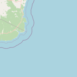
The landscape of Beowa National Park presents a coastal environment of subtle but distinctive character, shaped by ancient geological processes and ongoing erosion. The two sections of the park on either side of Twofold Bay exhibit notably different geological compositions. The northern section features sedimentary deposits from the Paleogene period, primarily ironstone and clay with occasional quartzite outcrops, creating terrain that rarely exceeds 100 meters in elevation. The most visually striking feature within this northern section is The Pinnacles, a multicolored erosion gully where white sands are dramatically overlaid with rusty red clay, creating an almost otherworldly landscape of contrasting colors. The southern section reveals much older geology, with metamorphic and Devonian-age rocks forming the coastline and featuring heavily folded sections at Red Point near Ben Boyd's Tower. The park's topography remains predominantly flat, with the tallest peak, Haycock Hill, reaching only 252 meters above sea level. The coastal headlands are exposed to the elements, supporting low ground-hugging heathland vegetation, while the more sheltered inland areas transition to open eucalypt woodland.

Beowa National Park ecosystems, habitats, and plant life

The ecological character of Beowa National Park reflects the interplay between the challenging coastal climate and diverse habitat niches created by the park's varied terrain. The headlands, exposed to the region's notably windy, dry, and cold conditions, support a low heathland community that hugs the ground, creating a distinctive coastal scrub. Moving inland, this heathland gives way to open eucalypt woodland, which forms the dominant habitat across most of the park. The two principal tree species are silvertop ash and red bloodwood, creating a woodland canopy that shelters the understory beneath. Within the more sheltered gullies and protected areas, pockets of rainforest persist, featuring species such as scentless rosewood and smooth mock-olive, representing remnants of more humid forest types that survive in microclimatic refuges. The park forms part of the Ulladulla to Merimbula Important Bird Area, identified by BirdLife International for its significance to bird populations, particularly the endangered swift parrot.

Beowa National Park wildlife and species highlights

Beowa National Park supports a notable diversity of wildlife, with particular significance attached to its bird populations. The park's designation as part of the Ulladulla to Merimbula Important Bird Area reflects its importance for swift parrots, an endangered species that migrates to the area. Survey work has documented 212 bird species within the park, with the heathland habitats supporting populations of eastern ground parrot and the endangered eastern bristlebird. The coastal beaches and sand dunes serve as breeding grounds for little terns, though this species has faced threats from recreational vehicle activity. Mammal diversity includes approximately 50 recorded species, though the park faces challenges from invasive species including feral cats, foxes, occasional feral dogs, and rabbits. The invasive bitou bush has posed a particular threat to vegetation in areas north of the Pambula River.

Beowa National Park conservation status and protection priorities

The conservation significance of Beowa National Park extends beyond its role as a protected coastal landscape, encompassing both biodiversity value and cultural reconciliation. The park's inclusion in the Ulladulla to Merimbula Important Bird Area highlights its international importance for migratory bird species, particularly the swift parrot. The 2022 renaming from Ben Boyd National Park to Beowa National Park represents a significant conservation outcome that extends beyond ecological considerations to acknowledge and honor Indigenous cultural values, with the orca holding deep significance for the Thaua traditional owners. The protection of diverse habitat types, from coastal heathland through eucalypt woodland to rainforest gullies, ensures the preservation of multiple ecological communities within a single protected area. Ongoing management challenges include control of invasive species such as bitou bush and introduced animals that threaten native wildlife populations.

Beowa National Park cultural meaning and human context

The cultural context of Beowa National Park encompasses both its Indigenous heritage and more recent colonial history, with the 2022 renaming bringing these dimensions into focus. The park lies within the traditional Country of the Thaua people, for whom the orca holds profound cultural and spiritual significance. According to Thaua mythology, their ancestors are orcas, and when one dies they are reincarnated as an orca. The selection of Beowa as the park's new name honored this connection following extensive consultation with Aboriginal and South Sea Islander communities involving more than 60 representatives. The more recent colonial history is represented by the incomplete sandstone tower commissioned by Benjamin Boyd in the 1840s to serve his whaling operations at Twofold Bay, a period when the area was part of the District of Port Phillip. The renaming process, culminating in a ceremony conducted by Thaua and South Sea Islander elders in November 2023, marks a meaningful moment of recognition and healing.

Top sights and standout views in Beowa National Park

The Pinnacles stands as the park's most distinctive natural feature, a multicolored erosion gully where white sands meet rusty red clay creating dramatic visual contrast. Ben Boyd's Tower, the incomplete sandstone structure overlooking Twofold Bay, provides both historical context and elevated views of the coastal landscape. The park's location on the South Coast positions it within an Important Bird Area supporting significant populations of swift parrots and other bird species. The 2022 renaming to Beowa, honoring the orca's significance to the Thaua people, represents a meaningful reconciliation between conservation outcomes and Indigenous cultural recognition. The diverse habitat mosaic, from heathland headlands through eucalypt woodland to sheltered rainforest gullies, supports remarkable biodiversity within a relatively compact coastal park.

Best time to visit Beowa National Park

The park can be visited throughout the year, though the exposed coastal location means conditions vary significantly with the seasons. Winter and spring typically bring cooler temperatures and stronger winds, while summer and autumn may offer more comfortable conditions for exploring the various trails and coastal viewpoints. The heathland wildflower displays tend to be more prominent during the spring months, and this is also when bird activity increases across the park's various habitats. Visitors interested in coastal scenery and photography may find the clearer conditions of autumn provide good visibility for viewing features like The Pinnacles and the coastline from Ben Boyd's Tower.

Park location guide

Geography guide, regional context, and park location map for Beowa National Park

Beowa National Park park geography, regions, and map view in Australia
Understand where Beowa National Park sits in Australia through a broader geographic reading of the surrounding landscape, nearby location context, and its mapped position within the national park landscape.

How Beowa National Park fits into Australia

Australia is a constitutional monarchy and federal parliamentary democracy comprising six states and ten territories. With a population of nearly 28 million, it is one of the world's most urbanised countries, with most people concentrated on the eastern seaboard. The country has a high Human Development Index and is known for its cultural diversity, ancient Aboriginal heritage, and unique wildlife.

Wider geography shaping Beowa National Park in Australia

Australia occupies the entire Australian continent, the island of Tasmania, and numerous smaller islands. It is the world's flattest and driest inhabited continent, featuring vast deserts in the interior (the Outback), tropical rainforests along the eastern coast, and a coastline bordering the Indian and Pacific Oceans.

Map view of Beowa National Park

Use this park location map to pinpoint Beowa National Park in Australia, understand its exact geographic position, and read its mapped placement within the surrounding landscape more clearly.

Pigeon | © OpenStreetMap contributors

Location context for Beowa National Park

New South Wales
Park atlas

Discover surrounding protected landscapes and trace the regional park geography of the New South Wales South Coast.

Explore Nearby National Parks and Coastal Protected Areas Beyond Beowa National Park
Browse a curated selection of national parks and coastal protected areas located near Beowa National Park, offering diverse landscapes from heathland headlands to eucalypt woodlands. Compare these conservation landscapes to understand the broader regional context of protected areas along Australia's South Coast, tracing their geographic spread and ecological connections.
Marine protected areaVictoria

Cape Howe Marine National Park: Victoria's Dramatic Southern Ocean Marine Protected Area

Rugged coastlines and marine ecosystem discovery in East Gippsland.

Delve into Cape Howe Marine National Park, a protected marine area anchoring Victoria's eastern coastline. This park protects a stretch of the Southern Ocean meeting dramatic rocky headlands and exposed shores. Its location at the far eastern tip of Victoria, adjacent to national parks, highlights a significant continuum of protected natural landscapes. Explore the mapped marine geography and the powerful coastal environment that defines this remote protected area.

Area
40.5 km²
Established
2002
IUCN
II
National parkNew South Wales

Mimosa Rocks National Park: Coastal Protected Area Atlas and Geographic Discovery

New South Wales National Park with Mapped Coastal Terrain

Mimosa Rocks National Park offers a compelling glimpse into Australia's protected coastal geography. This national park showcases a dynamic landscape where rocky outcrops and sweeping beaches define the Sapphire Coastline within New South Wales. Engage with its mapped boundaries and understand its role as a vital part of the regional protected area network, perfect for detailed atlas exploration and appreciating natural landscape context.

Area
57 km²
Established
1973
IUCN
II
National parkNew South Wales

Biamanga National Park: Protected National Park with Volcanic Landscape & Regional Geography

Discover mapped terrain and natural park boundaries.

Biamanga National Park is a significant protected area in New South Wales, Australia, notable for its volcanic mountain landscape dominated by Mumbulla Mountain. This national park provides valuable context for understanding regional geography, offering insights into its unique terrain, granite formations, and creek systems. Explore its protected boundaries and the ecological significance of this distinct natural landscape.

Area
137.49 km²
Established
1994
IUCN
II
Relief
Mountain
National parkNew South Wales

Wadbilliga National Park: Exploring New South Wales' Rugged Protected Landscape

Discover its mapped terrain and diverse ecosystem geography.

Wadbilliga National Park in New South Wales is a prime example of a large, remote protected area characterized by its rugged natural terrain and diverse ecosystems. Spanning approximately 985 square kilometres, the park features dramatic geographic contrasts, from deep gorges carved by rivers like the Tuross to expansive plateaus and sheltered gullies supporting varied vegetation communities. Its designation as a national park underscores its importance for conservation and provides a unique opportunity for understanding the mapped landscape context of southeastern Australia.

Area
985.3 km²
Established
1979
IUCN
Ib
Marine protected areaVictoria

Point Hicks Marine National Park: Victoria's Transitional Marine Protected Area Exploration

Mapped underwater geography and diverse coastal ecosystems

Point Hicks Marine National Park represents a unique warmer eastern marine environment within Victoria, Australia. This protected area safeguards underwater terrains including kelp forests and rocky reefs, crucial for biodiversity. Explore the geography of this marine park, understand its role as a transitional biogeographic zone, and discover the mapped landscapes that distinguish it from western Victoria's cooler waters.

Area
40 km²
Established
2002
IUCN
II
National parkNew South Wales

Kooraban National Park: Protected Area Map and Landscape Geography in New South Wales

Explore critical marsupial habitat and transitional terrain.

Kooraban National Park in New South Wales is a protected national park recognized for its role in conserving vulnerable marsupial species and its distinctive transitional landscape. Spanning over 11,500 hectares, the park connects inland tableland environments with coastal ecosystems, defined by the Narira Creek valley and Tuross River system. Its geography supports four distinct vegetation communities, making it a vital area for endangered animal habitats and broader conservation efforts within southeastern Australia. This park provides essential context for understanding regional geography and protected-area networks.

Area
116.26 km²
Established
2001
IUCN
II
National parkVictoria

Lind National Park: A Historic National Park Protecting East Gippsland Forest Landscapes

Mapped Protected Area with Early Conservation Significance in Victoria

Lind National Park, designated in 1925, is a notable protected area situated in Victoria's East Gippsland region. Covering 1,370 hectares, it safeguards representative forested terrain characterized by eucalypt woodlands, typical of the area's undulating topography. Its historical status as one of Victoria's earliest national parks underscores its importance for understanding the evolution of conservation in Eastern Australia. The park's accessible location along the Princes Highway provides a straightforward opportunity to experience its natural environment and regional geography.

Area
13.7 km²
Established
1925
IUCN
II
National parkNew South Wales

Eurobodalla National Park: New South Wales Coastal Protected Landscape and Geographic Atlas

Explore its mapped protected boundaries and unique estuarine wetland habitats.

Eurobodalla National Park represents a critical segment of the New South Wales coastline, distinguished by its designation as a national park. The park's geography is characterized by a mosaic of coastal terrains, including sandy shores, river estuaries, and vegetated headlands, which collectively form essential protected landscapes. It is particularly recognized for its role in supporting migratory bird populations and serves as a key site for understanding coastal ecology and conservation efforts within Australia. Through its mapped protected areas, Eurobodalla National Park provides valuable insights into the regional geography and the distribution of vital natural habitats.

Area
29.13 km²
Established
1995
IUCN
II

Common questions about visiting, size, designation, and location context for Beowa National Park

Beowa National Park FAQs for park facts, access, geography, and protected area context
Find quick answers about Beowa National Park, including protected-area facts, park geography, trail and visitor context, and how the park fits into its surrounding country and regional landscape.
MoriAtlas Explorer

Continue Your Protected Areas Search Across the Global Atlas

Deepen your exploration by continuing the structured search for national parks and protected areas worldwide. Utilize the comprehensive filtering capabilities to compare different conservation landscapes and refine your understanding of global park geography. Discover more about the distribution and characteristics of protected natural areas.

Global natural geography