Mori Atlas logo
National parkCát Tiên National Park

Discover the expansive lowland tropical forests and vital wetlands of Vietnam's Cát Tiên National Park.

Cát Tiên National Park: Vietnam's Key Protected Landscape and National Park Atlas Entry

Cát Tiên National Park stands as a significant protected area within Vietnam, encompassing approximately 720 square kilometers of vital lowland tropical forest, bamboo woodlands, and extensive seasonal wetlands. Situated in southern Vietnam, its geography is defined by the Dong Nai River system, creating unique flooded grasslands and marshes, most notably the Bàu Sấu (Crocodile Lake). As a critical component of the Đồng Nai Biosphere Reserve, Cát Tiên offers a profound insight into regional protected-area geography and mapped landscape context for those exploring Southeast Asia's natural heritage.

Tropical forestWetlandsPrimatesBirdwatchingRamsar siteBiosphere reserve
Stylized illustration of a waterfall, river, and forest with colorful mountains.

Cát Tiên National Park

National park

Park overview

Structured park overview, official facts, and landscape profile for Cát Tiên National Park

Cát Tiên National Park park facts, protected area profile, and essential visitor context
Review the core facts for Cát Tiên National Park, including designation, size, terrain, visitor scale, habitats, and operating context in one park-focused overview.

About Cát Tiên National Park

Cát Tiên National Park stands as a testament to Vietnam's commitment to preserving its natural heritage in the face of significant environmental challenges. The park protects one of the country's most ecologically significant lowland tropical forest ecosystems, providing sanctuary for an extraordinary diversity of flora and fauna despite decades of historical disturbance from wartime defoliation and post-war logging activities. The landscape encompasses a remarkable range of habitats, from semi-evergreen primary forest in the most protected valleys to extensive bamboo thickets that have colonized areas of former forest degraded by human activity and chemical herbicides during the Vietnam War. The Bàu Sấu wetland complex, comprising Crocodile Lake and adjacent seasonal floodplains covering over 13,000 hectares, represents a critical habitat for waterbirds and aquatic species, supporting the park's Ramsar designation as an internationally significant wetland. Beyond its ecological value, the park contains archaeological sites revealing a sophisticated Hindu civilization that once thrived along the Dong Nai River, with gold, bronze, ceramic, and stone artifacts displayed in Da Lat museum. The park's management operates under the Ministry of Agriculture and Rural Development, with forest rangers (Kiểm lâm) tasked with combating poaching, illegal logging, and fire management across the challenging terrain.

Quick facts and research context for Cát Tiên National Park

Cát Tiên National Park occupies roughly 720 square kilometers in southern Vietnam, making it one of the nation's largest lowland forest reserves. The protected area straddles three provinces: Đồng Nai, Bình Phước, and Lâm Đồng, situated about 150 kilometers north of Ho Chi Minh City. The park features a complex mosaic of habitats including primary forest covering only about 2% of the area, extensive bamboo forests representing approximately 40% of the landscape, and seasonal grasslands and wetlands making up roughly 10%. The park was established in 1992 and received its current unified status in 1998 when the Nam Cat Tien, Tay Cat Tien, and Cat Loc sectors were combined. It holds Ramsar Wetland status for the Bàu Sấu ecosystem and forms part of the Đồng Nai Biosphere Reserve.

Park context

Deeper park guide and search-rich context for Cát Tiên National Park

Cát Tiên National Park history, landscape, wildlife, and travel context
Explore Cát Tiên National Park through its history, landscape character, ecosystems, wildlife, conservation priorities, cultural context, and seasonal travel timing in a structured park guide built for atlas discovery and search intent.

Why Cát Tiên National Park stands out

Cát Tiên National Park is best known for its population of endangered primates, particularly the endemic golden-cheeked gibbon, and its historic role as a refuge for the Vietnamese Javan rhinoceros, which was tragically poached to extinction in 2010. The park's Bàu Sấu (Crocodile Lake) wetland system, designated as a Ramsar site in 2005, represents one of the most significant seasonally flooded ecosystems in Vietnam. The archaeological discoveries near the park, revealing a previously unknown Shaiva Hindu civilization from the 4th to 9th centuries AD, add a remarkable cultural dimension to the reserve's significance.

Golden-cheeked gibbon with light brown fur and black face sitting on a tree branch among green foliage
Female golden-cheeked gibbon perched on a tree branch in Cát Tiên National Park

Cát Tiên National Park history and protected-area timeline

The territory now protected as Cát Tiên National Park has a complex conservation history reflecting Vietnam's broader political transformations. Initially gazetted as two separate protected sectors in 1978, Nam Cat Tien and Tay Cat Tien received formal protection during a period when the nation was still emerging from conflict. The discovery of a breeding population of the critically endangered Vietnamese Javan rhinoceros in the early 1990s catalyzed international attention and led to the creation of the Cat Loc sector as a dedicated rhinoceros reserve in 1992. This remarkable find placed Cát Tiên at the center of global conservation efforts for one of the rarest large mammals on Earth. The three sectors were formally consolidated into a single national park in 1998, creating the unified protected area that exists today. The park's surrounding landscapes were historically inhabited by Ma and Stieng peoples, with many residents relocated to Talai village following the establishment of formal protection. Vietnam's modern integration into global conservation frameworks brought additional designations, including membership in the Đồng Nai Biosphere Reserve in 2011 and Ramsar Wetland status in 2005 for the critical Bàu Sấu wetland system.

Cát Tiên National Park landscape and geographic character

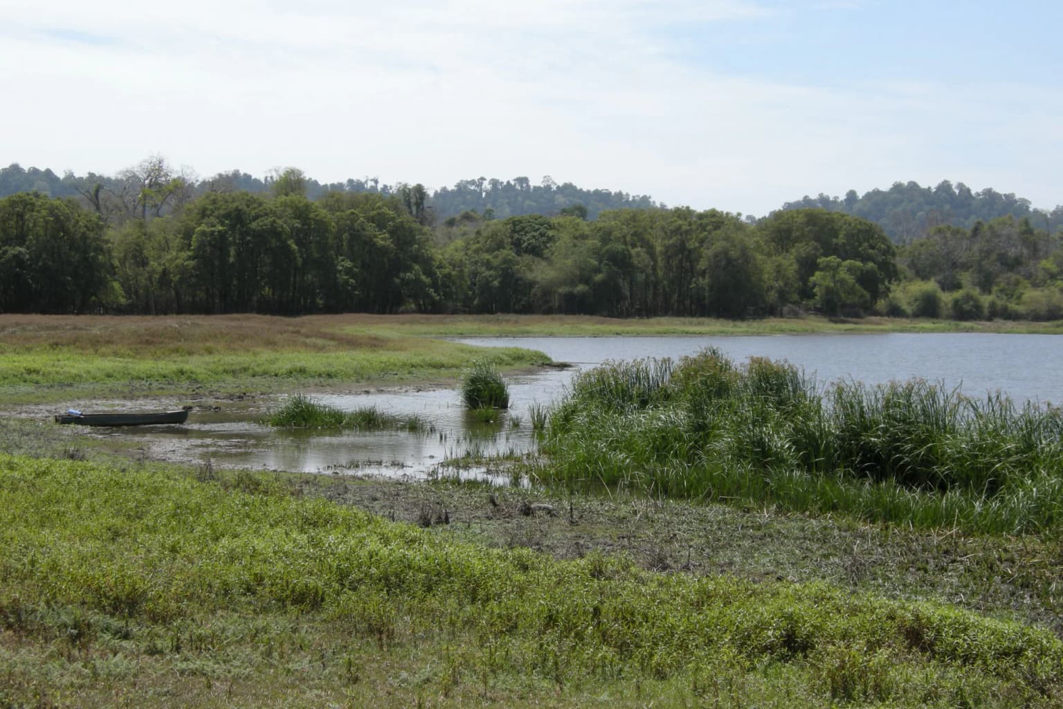
The physical geography of Cát Tiên National Park is characterized by undulating lowland terrain typical of southern Vietnam's interior provinces, with elevations ranging from near sea level to approximately 300 meters above sea level. The landscape is fundamentally shaped by the Dong Nai River system, which flows through the park and provides the hydrological engine for the extensive seasonal flooding that creates the park's distinctive wetland character. During the rainy season, floodwaters from the Dong Nai backflow into northern Nam Cat Tien, replenishing the chain of lakes known collectively as Bàu Sấu, including Bau Sau (Crocodile Lake), Bau Chim, Bau Co, and surrounding grasslands covering approximately 2,500 hectares. The park's western portion contains more rolling terrain while the eastern half features extensive flat areas with numerous swamps and wet meadows, typically ranging from 3 to 10 hectares, often surrounded by swamp forest. The distinctive bamboo forests, covering roughly 40% of the park's area, represent a successional landscape where native hardwood forest has been replaced by bamboo following disturbance from logging, fire, and wartime herbicide exposure.

Northern smooth-tailed treeshrew clinging to a tree trunk with green foliage
Northern smooth-tailed treeshrew climbing a tree in Cát Tiên National Park

Cát Tiên National Park ecosystems, habitats, and plant life

The ecological character of Cát Tiên is defined by seasonal tropical forest ecosystems that have evolved under pronounced wet and dry seasonal cycles. Primary evergreen forest, now limited to perhaps 2% of the Nam Cat Tien area, supports the highest biodiversity with emergent trees from the Dipterocarpaceae and Fabaceae families dominating the canopy. Species such as Dipterocarpus alatus and Hopea odorata represent commercially important timber species that have been targeted by historical logging operations. The understory contains a remarkable diversity of palms including the endemic Licuala cattienensis, as well as fruit trees providing critical food resources for wildlife, particularly the numerous fig species and wild bananas. The extensive bamboo forest zone represents a degraded successional stage where natural forest has been displaced, with species such as Bambusa balcooa and Gigantochloa dominating. The riparian zones along streams and in lowland areas support freshwater swamp forest with distinctive species including Ficus benjaminas and Livistona palms. The seasonally flooded grasslands and wetlands support different ecological communities adapted to periodic inundation, with emergent vegetation providing important habitat for waterbirds and aquatic fauna.

Coiled Oligodon cattienensis snake with brown and orange markings on a metallic surface
Oligodon cattienensis snake coiled in a container at Cát Tiên National Park

Cát Tiên National Park wildlife and species highlights

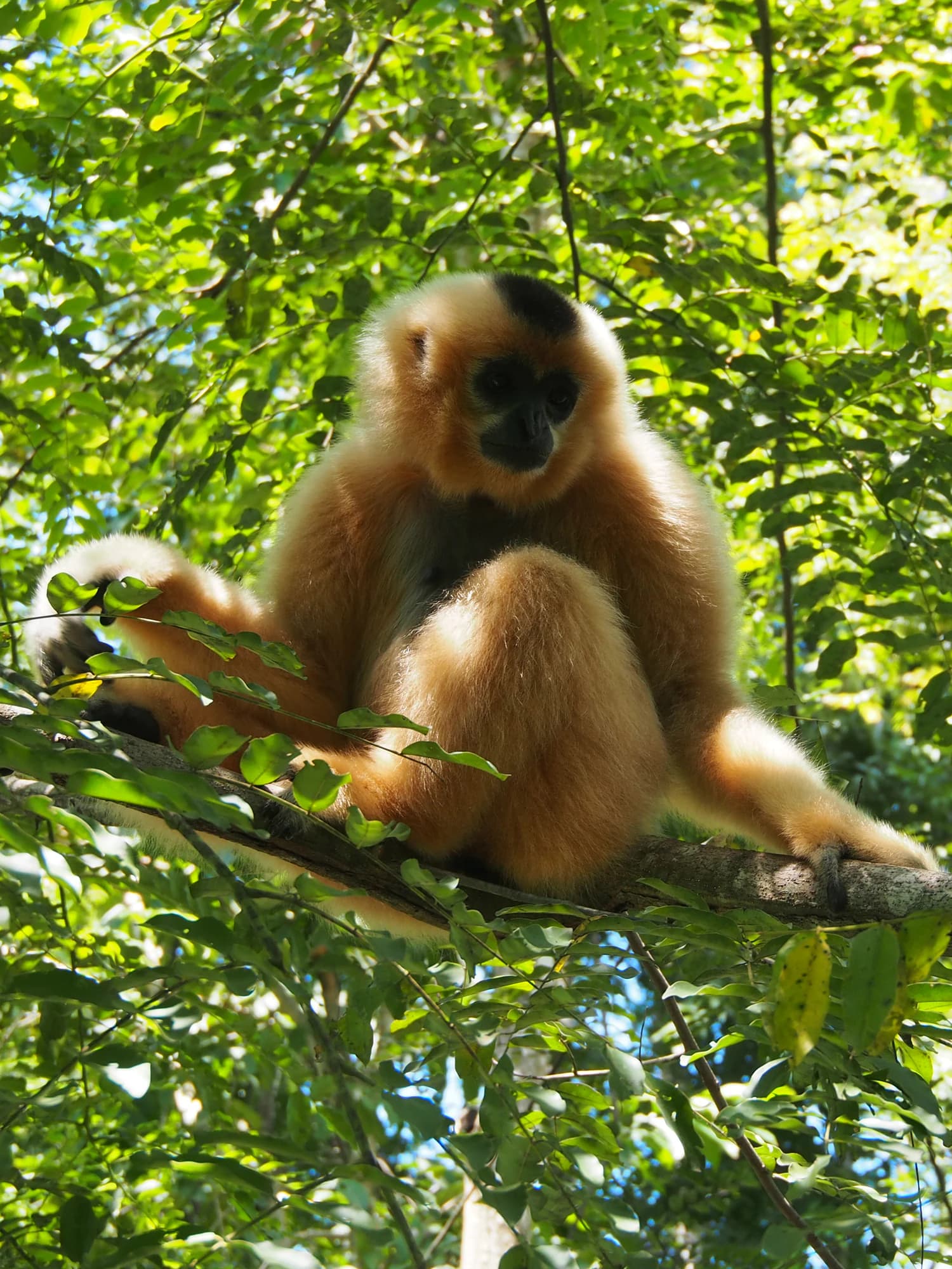
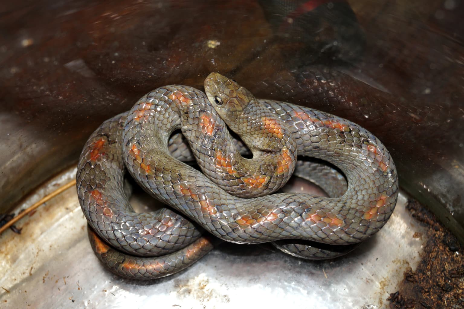
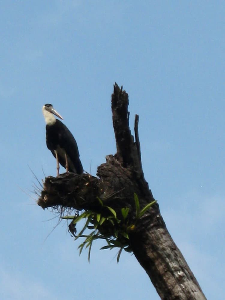
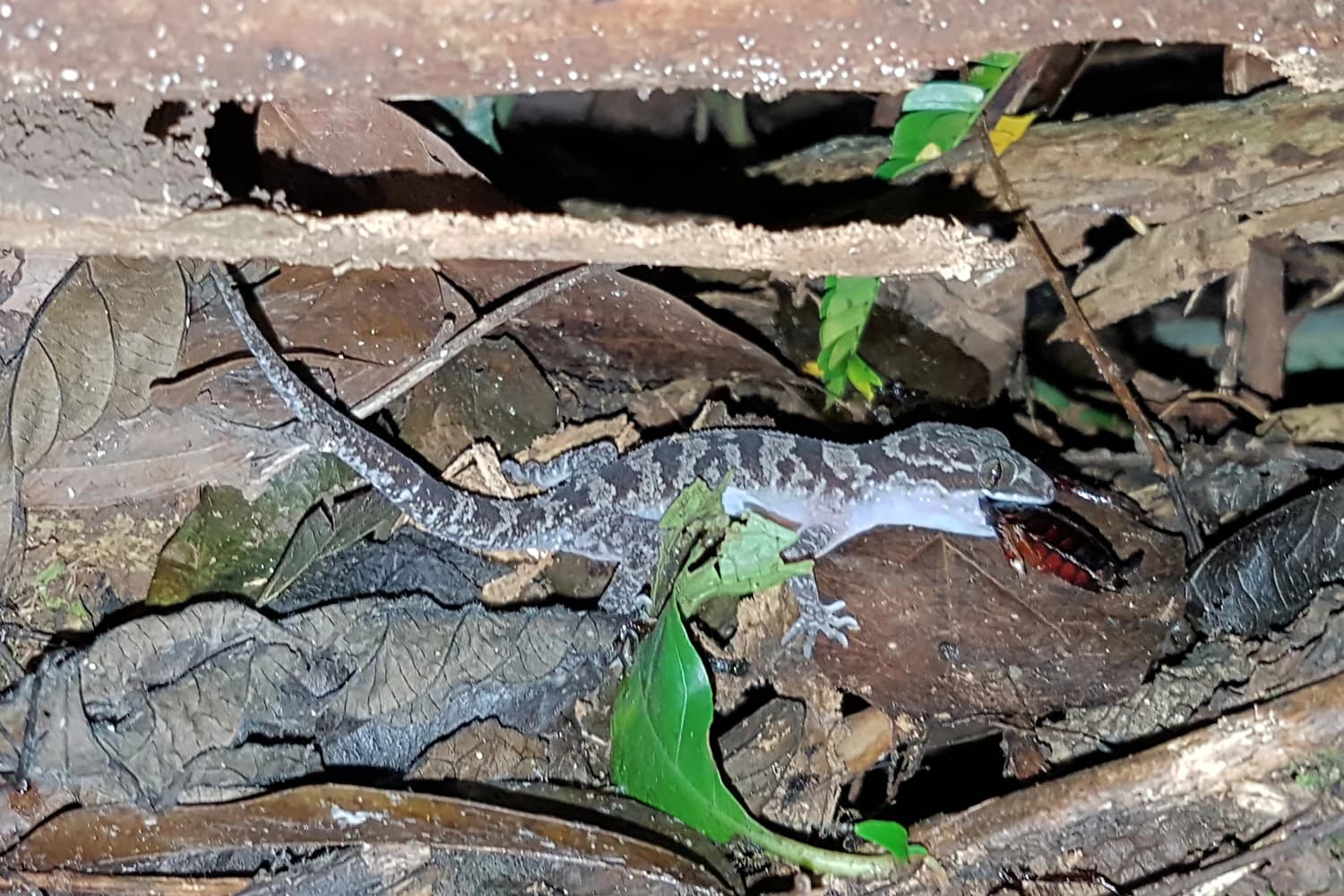
Cát Tiên supports an exceptional mammalian fauna that includes several globally threatened species and a remarkable diversity of primates. The golden-cheeked gibbon (Nomascus gabriellae), endemic to this region of Vietnam, remains one of the park's most iconic species, though populations have declined significantly from historical levels. Other primates include the black-shanked douc langur, Indochinese lutung, and the nocturnal pygmy slow loris. Large mammals include the endangered Asian elephant (Elephas maximus), the vulnerable gaur (Bos gaurus), and the critically endangered Sunda pangolin. The park historically supported one of only two remaining populations of the Javan rhinoceros in the world until the last individual was poached in 2010, marking a tragic extinction event. The bird fauna is exceptionally diverse with over 300 species recorded, including the green peafowl, various pheasants such as Germain's peacock-pheasant and Siamese fireback, and hornbills including the great hornbill, oriental pied hornbill, and wreathed hornbill. The park's reptile population includes the Siamese crocodile and numerous snake species, while the amphibian fauna includes the Vietnamese bug-eyed frog (Theloderma vietnamense), one of several endemic species bearing the catienensis name.

Wooly-necked stork standing on a dead tree stump with clear blue sky background
Wooly-necked stork perched on a dead tree trunk in Cát Tiên National Park

Cát Tiên National Park conservation status and protection priorities

Cát Tiên National Park represents one of Vietnam's most important conservation areas, protecting approximately 30% of the nation's species within its boundaries while supporting 40 species listed on the IUCN Red List. The park's conservation significance is amplified by its designation as part of the Đồng Nai Biosphere Reserve, recognizing its role in maintaining ecological processes while supporting sustainable human use of the surrounding landscape. The Ramsar designation of the Bàu Sấu wetland system in 2005 provides international recognition of the wetland values and obligations for sustainable management. Conservation challenges remain substantial, with encroachment from local communities, illegal logging, and poaching continuing to pressure wildlife populations. The park's relatively small size relative to the home ranges of large species such as elephants creates management complications, leading to human-wildlife conflict as animals move beyond park boundaries. The Dao Tien Endangered Primate Species Centre, established in 2008 through collaboration with international conservation organizations, focuses on rescue, rehabilitation, and release of the park's four endangered primates, contributing to conservation outcomes while educating visitors about primate conservation needs.

Cát Tiên National Park cultural meaning and human context

The landscapes of Cát Tiên have been inhabited by human communities for centuries, with archaeological evidence revealing a sophisticated civilization predating the modern era. The Cát Tiên archaeological site, located just outside the park on the northern bank of the Dong Nai River, contains the remains of a Shaiva Hindu civilization that likely inhabited the area between the 4th and 9th centuries AD. Excavations conducted between 1994 and 2003 revealed temples and a substantial collection of artifacts including gold, bronze, ceramic, colored stone, and glass items, now displayed in the Da Lat museum. The surrounding area was historically occupied by Ma and Stieng peoples, particularly in the western portions of what is now Đồng Nai Province. Following the establishment of the protected area, many of these communities were resettled in Talai village to the southwest of Nam Cat Tien, reflecting the complex relationship between conservation objectives and traditional land use patterns. The park name itself derives from the Vietnamese designation reflecting the area's historical and cultural identity.

Close-up of a gecko with mottled brown and gray skin consuming a cockroach among fallen leaves and branches
Cyrtodactylus cattienensis gecko eating a cockroach in Cát Tiên National Park

Top sights and standout views in Cát Tiên National Park

The ecological richness of Cát Tiên makes it a premier destination for wildlife observation in Vietnam, with guided treks offering opportunities to encounter gibbons, langurs, and a remarkable diversity of bird species including hornbills and pittas. The Bàu Sấu wetland system, particularly during the dry season when water sources become concentrated, provides exceptional birdwatching opportunities with species such as the woolly-necked stork and lesser adjutant frequently observed. The archaeological site near the park entrance offers a unique cultural dimension, revealing the ancient Hindu civilization that once thrived in this forested landscape. The Dao Tien Endangered Primate Species Centre provides educational tours showcasing rehabilitation work with golden-cheeked gibbons and other endangered primates, offering visitors direct engagement with conservation efforts. The diverse habitats from primary forest to bamboo groves and seasonal wetlands create varied experiences depending on the season and specific area visited within the park.

A landscape view of a shallow body of water surrounded by dense green vegetation and trees under a partly cloudy sky
A tranquil wetland scene within Cát Tiên National Park, Vietnam, featuring lush vegetation and calm waters

Best time to visit Cát Tiên National Park

The optimal time to visit Cát Tiên National Park depends on the specific experiences sought, with the dry season from December through April generally offering easier access to forest trails and improved wildlife viewing opportunities as animals congregate around remaining water sources. The wet season from May through November brings substantial rainfall that can make trails difficult and restrict access to certain areas, though the flooded wetland areas reach their maximum extent and waterbird populations peak during this period. The shoulder months of November and May often provide a balance between accessibility and seasonal character, though visitor facilities may be more limited during these transition periods. The driest months of January through March typically offer the most comfortable conditions for trekking and wildlife observation, though the park remains accessible year-round and each season presents distinct ecological characteristics worth experiencing.

Park location guide

Geography guide, regional context, and park location map for Cát Tiên National Park

Cát Tiên National Park park geography, regions, and map view in Vietnam
Understand where Cát Tiên National Park sits in Vietnam through a broader geographic reading of the surrounding landscape, nearby location context, and its mapped position within the national park landscape.

How Cát Tiên National Park fits into Vietnam

Vietnam, officially the Socialist Republic of Viet Nam, is a unitary communist state in Southeast Asia. It occupies roughly 331,000 square kilometres along the eastern edge of Mainland Southeast Asia, with a population exceeding 102 million. The country is bordered by China to the north, Laos and Cambodia to the west, and has maritime boundaries in the Gulf of Thailand and South China Sea.

Wider geography shaping Cát Tiên National Park in Vietnam

Vietnam occupies the eastern edge of Mainland Southeast Asia, stretching along the Gulf of Thailand to the southwest and the South China Sea to the east. The country is bordered by China to the north, and Laos and Cambodia to the west. It has a diverse landscape ranging from the Red River Delta in the north to the Mekong Delta in the south.

Map view of Cát Tiên National Park

Use this park location map to pinpoint Cát Tiên National Park in Vietnam, understand its exact geographic position, and read its mapped placement within the surrounding landscape more clearly.

Pigeon | © OpenStreetMap contributors

Location context for Cát Tiên National Park

Bình Phước ProvinceĐồng Nai ProvinceLâm Đồng Province

Explore the diverse forest terrain, unique wetland habitats, and protected-area scenery within Cát Tiên National Park.

Cát Tiên National Park Photos: Visual Guide to Vietnam's Lowland Tropical Forest Landscapes
Visually explore the distinct lowland tropical forest, extensive bamboo woodlands, and vital wetland systems that define Cát Tiên National Park. These images offer a detailed understanding of the park's diverse ecosystems, seasonal flooding patterns, and the critical habitats protecting endangered species within this significant Vietnamese protected area.

Golden-cheeked gibbon with light brown fur and black face sitting on a tree branch among green foliage

A large dark brown Gaur with curved horns grazing on grass in a forested area with green vegetation and trees

Northern smooth-tailed treeshrew clinging to a tree trunk with green foliage

Coiled Oligodon cattienensis snake with brown and orange markings on a metallic surface

Wooly-necked stork standing on a dead tree stump with clear blue sky background

Black and yellow banded snake resting on wet rocks covered in moss

Close-up of a gecko with mottled brown and gray skin consuming a cockroach among fallen leaves and branches

A landscape view of a shallow body of water surrounded by dense green vegetation and trees under a partly cloudy sky

Close-up of a green cat snake with patterned scales, head raised against dark background

River with muddy water and rocky banks surrounded by dense green forest under a clear sky

A black bear in a lush green forest environment surrounded by branches and leaves

White lanternfly insect with spotted wings and long curved tail resting on tree trunk with moss

Cave interior with hanging stalactites and rock formations

Bar-bellied Pitta bird with green, yellow, and blue plumage perched on a branch surrounded by green leaves.

Group of water buffalos walking across dry grassy field with scattered trees in background

A close-up of Licuala cattienensis plant with fan-shaped leaves in a dense tropical forest with tall trees and leaf litter on the ground

Park atlas

Trace the geographic spread of Vietnam's protected areas, exploring adjacent landscapes for comparison.

Compare Nearby National Parks and Protected Areas Surrounding Cát Tiên National Park
From Cát Tiên National Park, continue your exploration by browsing nearby national parks and other protected areas across Vietnam's diverse geographic regions. This provides crucial regional context, allowing you to trace the spread of conservation landscapes and compare specific park characteristics for a comprehensive atlas-style understanding.
National parkĐắk Nông Province

Tà Đùng National Park: Protected Landscape and Geographic Atlas Entry

Mapped Boundaries and Regional Terrain Context

Tà Đùng National Park represents a vital protected landscape within Vietnam's Đắk Nông Province, offering rich opportunities for geographic discovery. This entry details the park's identity as a national park, focusing on its mapped boundaries and its contribution to the regional atlas. Explore the fundamental geographic features and protected land context that define Tà Đùng National Park, facilitating a deeper understanding of its place within the broader natural landscape.

Area
209 km²
Established
2018
IUCN
II
Relief
Mountain
National parkBình Phước Province

Bù Gia Mập National Park: Protected Landscape and Regional Geography in Vietnam

Discover its mapped boundaries and terrain in Bình Phước Province.

Bù Gia Mập National Park is a designated national park in Vietnam, located within the geographical area historically associated with Bình Phước Province. This page focuses on providing a structured understanding of the park's protected land status and its mapped geographic features. Explore the context of this protected landscape, its position within the regional geography, and its role as an element for atlas-based discovery of Vietnam's natural areas.

Area
260.32 km²
Established
2002
IUCN
II
Relief
Upland
National parkTây Ninh Province

Lò Gò, Xa Mát National Park: Exploring Protected Landscape Boundaries and Regional Geography

Vietnam National Park Mapped Terrain and Atlas Context

Discover Lò Gò, Xa Mát National Park, a vital protected area situated in Tây Ninh Province. This entry focuses on its role as a national park, providing key insights into its mapped boundaries and contribution to the regional geography. Understand its landscape context as part of a broader atlas of protected lands, offering a factual basis for geographic discovery and conservation area research.

Area
300.22 km²
Established
2002
IUCN
II
Relief
Lowland
National parkĐắk Lắk Province

Yok Đôn National Park: Vietnam's Expansive Lowland Forest Protected Landscape and Regional Geography

Mapped boundaries within Đắk Lắk Province, part of a transboundary conservation area.

Yok Đôn National Park is Vietnam's largest lowland forest national park, covering approximately 1,155 square kilometers in Đắk Lắk Province. This protected area is characterized by its rare khộp forest ecosystem and serves as a crucial refuge for large mammals. Situated near the Cambodian border, it forms a key component of one of Southeast Asia's largest continuous protected area networks, offering significant insights into regional protected landscape geography and conservation connectivity.

Area
1,155.45 km²
Established
1986
IUCN
II
Relief
Lowland
National parkLâm Đồng Province

Bidoup Nui Ba National Park: Vietnam National Park Atlas and Protected Landscape

Explore mapped boundaries and regional geography of this protected area.

Bidoup Nui Ba National Park is a prominent national park located within the Lâm Đồng Province of Vietnam's Central Highlands. This park serves as a focal point for understanding the regional geography and the distribution of protected lands across Vietnam. Its mapped boundaries define a significant natural landscape, offering users detailed atlas-style context for geographic exploration and protected-area research.

Area
648 km²
Established
2004
IUCN
II
Relief
Mountain
National parkNinh Thuận Province

Phước Bình National Park: Protected Area Identity and Geographic Setting in Ninh Thuận

Explore Vietnam's Phước Bình National Park and its mapped terrain.

Phước Bình National Park represents a distinct national park entity situated within Ninh Thuận Province, Vietnam. This destination facilitates an atlas-driven understanding of its protected landscape, emphasizing its geographical placement and mapped boundaries. Explore the core identity of this park as a component of Vietnam's protected areas network and its specific regional landscape context.

Area
198.14 km²
Established
2006
IUCN
II
Relief
Mountain
Watercolor illustration of a river, trees, and hills in a natural landscape.
National parkĐắk Lắk Province

Chư Yang Sin National Park: Mapped Protected Landscape in Đắk Lắk Province

Explore its protected boundaries and regional geographic context.

Chư Yang Sin National Park stands as a key protected natural area within Vietnam's Central Highlands. This national park, located in the expansive Đắk Lắk Province, provides a rich subject for geographic discovery. Understanding its mapped boundaries and position within the regional landscape offers valuable context for atlas-based exploration of Vietnam's protected lands.

Area
589.47 km²
Established
2002
IUCN
II
Scope
Terrestrial
National parkNinh Thuận Province

Núi Chúa National Park: Protected Landscape and Geographic Atlas Entry

Explore Ninh Thuận Province's national park geography.

Núi Chúa National Park is a key protected area within Vietnam's Ninh Thuận Province, offering vital context for understanding regional geography and mapped natural landscapes. This entry provides the essential geographic details for the park, serving as a foundational element for atlas-based discovery of Vietnam's protected lands. Delve into its mapped boundaries and landscape identity to appreciate its significance.

Area
317.05 km²
Established
2003
IUCN
II
Relief
Mountain

Common questions about visiting, size, designation, and location context for Cát Tiên National Park

Cát Tiên National Park FAQs for park facts, access, geography, and protected area context
Find quick answers about Cát Tiên National Park, including protected-area facts, park geography, trail and visitor context, and how the park fits into its surrounding country and regional landscape.
MoriAtlas Explorer

Continue Your Protected Areas Search Across the Global Atlas

Deepen your exploration by continuing the structured search for national parks and protected areas worldwide. Utilize the comprehensive filtering capabilities to compare different conservation landscapes and refine your understanding of global park geography. Discover more about the distribution and characteristics of protected natural areas.

Global natural geography