Mori Atlas logo
National parkCaura National Park

Explore the vast tropical rainforest basin and its mapped protected boundaries within the Guianan Highlands.

Caura National Park: Venezuela's Largest National Park and Protected Landscape

(Parque nacional Caura)

Caura National Park is a monumental protected area, established in 2017 to safeguard the expansive Caura River basin within Venezuela's Guianan Highlands. Covering approximately 7.5 million hectares, it stands as the nation's largest national park, preserving one of the most intact tropical rainforest ecosystems in South America. This park plays a crucial role in the Orinoco River system, representing decades of conservation planning focused on protecting critical watershed habitats and significant biodiversity across a vast, ecologically vital landscape.

National ParkTropical RainforestGuianan HighlandsOrinoco BasinSouth AmericaWildlife Conservation

Caura National Park

National park

Park overview

Structured park overview, official facts, and landscape profile for Caura National Park

Caura National Park park facts, protected area profile, and essential visitor context
Review the core facts for Caura National Park, including designation, size, terrain, visitor scale, habitats, and operating context in one park-focused overview.

About Caura National Park

Caura National Park occupies a vast territory in southern Venezuela, protecting the entire Caura River basin within the Guianan Highlands moist forests ecoregion. As the largest national park in Venezuela, spanning approximately 7.5 million hectares, it represents a major commitment to preserving one of the country's most ecologically significant tropical rainforest regions. The park's creation in 2017 under the administration of Nicolás Maduro marked the culmination of decades of conservation planning, with the first management plan presented in 2018. The Caura River itself is a major tributary of the Orinoco River, draining an extensive area of the Guianan Highlands and carrying its waters northward through the park before joining Venezuela's largest river system. The park straddles the boundary between Bolívar State and Amazonas State, two of Venezuela's most sparsely populated regions where extensive tracts of intact forest remain. The ecosystem supports a remarkable diversity of species despite increasing pressures from hunting and human population growth in surrounding areas, with research by the University of Washington and the Wildlife Conservation Society documenting both the ecological richness and the conservation challenges facing this remote protected area.

Quick facts and research context for Caura National Park

Caura National Park covers 75,340 square kilometers in southern Venezuela, making it the country's largest protected area and the most recently established national park (2017). The park protects the Caura River basin, a major tributary of the Orinoco River, within the Guianan Highlands moist forests ecoregion. The area experiences a tropical rainforest climate with average temperatures around 32°C and annual rainfall exceeding 2,200 millimeters. It spans the boundary between Bolívar and Amazonas states in the Guayana Region, one of the most biologically diverse areas in Venezuela.

Park context

Deeper park guide and search-rich context for Caura National Park

Caura National Park history, landscape, wildlife, and travel context
Explore Caura National Park through its history, landscape character, ecosystems, wildlife, conservation priorities, cultural context, and seasonal travel timing in a structured park guide built for atlas discovery and search intent.

Why Caura National Park stands out

Caura National Park is best known for its extraordinary extent as Venezuela's largest national park, protecting a nearly complete tropical rainforest basin in the Guianan Highlands. The park preserves critical habitat for populations of jaguar, puma, tapir, and various primate species within an intact river ecosystem that drains into the Orinoco. Its establishment represents the culmination of over five decades of conservation planning, from the 1968 forest reserve declarations through the 2008 Caura Plan to the 2017 formal national park designation. The park's fauna includes notable species such as the white-cheeked peccary, yellow-bellied spider monkey, and white-tailed turkey, all within a landscape of immense ecological significance.

Caura National Park history and protected-area timeline

The protection of the Caura region evolved through several distinct phases spanning nearly five decades. In 1968, during the presidency of Raúl Leoni, the Venezuelan government decreed the creation of several protected spaces, including forest reserves that incorporated what would later become the Caura protected area. This initial designation recognized the ecological significance of the region's forests but did not provide the comprehensive protection of a national park. Four decades later, in 2008, the government of Hugo Chávez created the Caura Plan, specifically aimed at protecting the resources of the Caura River basin. This plan represented a more focused approach to watershed protection and sustainable resource management for the region. Finally, in March 2017, the administration of Nicolás Maduro decreed the formal creation of Caura National Park, elevating the protected status to the highest national category and providing the legal framework for comprehensive park management. The first official management plan was presented in March 2018, establishing guidelines for conservation, sustainable use, and visitor management within the park. This progression from broad forest reserves to targeted river basin planning to full national park status reflects the evolving understanding of the region's ecological importance and the increasing sophistication of Venezuela's protected area system.

Caura National Park landscape and geographic character

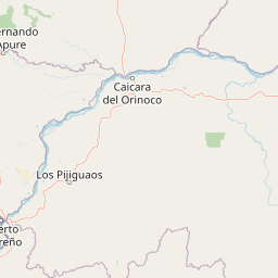
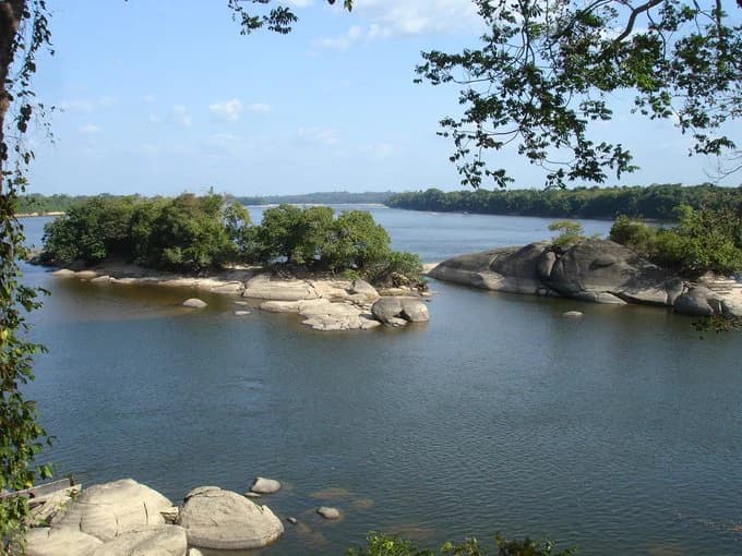
The landscape of Caura National Park is defined by the extensive tropical rainforest covering the Caura River basin within the Guianan Highlands. The terrain consists largely of rolling uplands and forested plains characteristic of the Guianan region, with the Caura River and its numerous tributaries carving corridors through the dense vegetation. The park lies at relatively low elevations for a highland region, with the tropical rainforest ecosystem extending across the basin at elevations typically below 500 meters. The region's climate is characterized by high temperatures, with average annual temperatures around 32°C, and substantial rainfall, with average annual precipitation of approximately 2,271 millimeters. This combination of warmth and moisture supports continuous forest cover across the landscape, with the Caura River serving as the primary drainage system carrying water northward to the Orinoco. The park's vast extent means it encompasses significant variation in local topography while maintaining the overall character of a tropical forest landscape.

Caura National Park ecosystems, habitats, and plant life

Caura National Park protects one of Venezuela's most extensive tropical rainforest ecosystems within the Guianan Highlands moist forests ecoregion. The park's vegetation is characterized by tall evergreen forest with a diverse canopy structure supporting numerous plant species. Key tree species found within the park include cabimo oil, carob tree, araguaney, mahogany, and carapa, representing the commercial and ecological backbone of the Guianan forest. The region falls squarely within the tropical rainforest life zone, where year-round warmth and abundant rainfall support continuous plant growth and a complex web of ecological interactions. The Caura River basin supports aquatic ecosystems that connect the forest interior to the broader Orinoco system, maintaining ecological connectivity across vast distances. The park's size and relative remoteness have allowed much of the original forest ecosystem to persist despite surrounding pressures, making it one of the most significant remaining tracts of intact tropical forest in Venezuela.

Caura National Park wildlife and species highlights

The wildlife community of Caura National Park includes a remarkable array of mammal, bird, and other animal species adapted to the tropical forest environment. Large mammals include the tapir (Tapirus terrestris), jaguar (Panthera onca), and puma (Puma concolor), representing the apex predators and large herbivores typical of intact Neotropical forests. The park supports populations of several peccary species, including the white-cheeked peccary (Tayassu pecari) and collared peccary (Pecari tajacu), which travel in social groups through the forest understory. Primate diversity includes the yellow-bellied spider monkey (Ateles belzebuth), a keystone species for seed dispersal in tropical forests. The bird fauna includes distinctive ground-dwelling species such as the white-tailed turkey (Crax alector) and red-tailed turkey (Mitu tomentosum), as well as numerous other bird species including cranes and other galliform birds. Additional mammals include the anteater (Myrmecophaga tridactyla), limpet or paca (Cuniculus paca), acouchi (Myoprocta pratti), and various marsupials including the common opossum (Didelphis marsupialis). Smaller mammals such as cachicamos (Dasypus spp.) and deer are also present. Research has documented that many of these populations face压力 from hunting as local human populations grow, highlighting the importance of active conservation management.

Caura National Park conservation status and protection priorities

Caura National Park represents Venezuela's largest and most recent contribution to national conservation, protecting an extensive tract of tropical forest that might otherwise face deforestation and degradation. The park's designation as a Category II protected area under IUCN guidelines provides a framework for biodiversity conservation while acknowledging the need for sustainable management. The Guianan Highlands moist forests are recognized as a globally significant ecoregion, and the park's protection of the Caura River basin maintains ecological connectivity to the broader Orinoco system. However, conservation challenges exist, with research by the University of Washington and the Wildlife Conservation Society documenting hunting pressure impacts on wildlife populations in the region. The transition from forest reserves (1968) through the Caura Plan (2008) to full national park status (2017) demonstrates an evolving commitment to conservation, with the 2018 management plan providing operational guidance for protecting this vast territory. The park's remote location between Bolívar and Amazonas states provides some natural protection, though effective conservation will require ongoing management resources and enforcement capacity.

Caura National Park cultural meaning and human context

Caura National Park occupies territory within the Guayana Region of Venezuela, an area with a long history of human presence though relatively low population density compared to other parts of the country. The region has been inhabited by indigenous peoples for millennia, with the Caura River serving as a traditional corridor for movement and resource use. The park's boundaries span the administrative border between Bolívar State and Amazonas State, two of Venezuela's least densely populated regions where indigenous communities maintain traditional land use patterns. While the park is managed as a strict protected area, the broader Caura basin has been subject to various development pressures and resource extraction activities over the decades. The evolution from 1968 forest reserves through the 2008 Caura Plan to the 2017 national park designation reflects not only ecological priorities but also the complex relationship between governmental conservation policy and the region's human communities.

Top sights and standout views in Caura National Park

Caura National Park stands as Venezuela's largest protected area and the most recently established national park, created in 2017 to protect the extensive Caura River basin within the Guianan Highlands. The park preserves one of the country's most intact tropical rainforest ecosystems, home to populations of jaguar, puma, tapir, and numerous other species. Its creation represents the culmination of over fifty years of conservation planning, from initial forest reserves in 1968 through the 2008 Caura Plan to formal national park designation. The park protects critical watershed habitat for a major Orinoco tributary, maintaining ecological connectivity across millions of hectares of forest. Wildlife includes notable species such as the white-cheeked peccary, yellow-bellied spider monkey, white-tailed turkey, and anteater, all within a landscape of exceptional ecological significance.

Best time to visit Caura National Park

Caura National Park's tropical rainforest environment means that visit conditions are shaped by the regional climate patterns. The wet season typically brings higher rainfall, with the forest at its most lush and water levels in the Caura River at their highest. The dry season may offer slightly easier movement through the landscape and clearer river conditions for navigation. However, the park's vast extent and remote location mean that visit planning requires careful attention to logistical arrangements and seasonal conditions. The average annual temperature of 32°C means warm conditions year-round, with high humidity characteristic of tropical forest environments. Visitors should be prepared for the combination of heat, humidity, and seasonal rainfall regardless of when they travel. The park's remote location between Bolívar and Amazonas states requires advance planning for access and supplies, with the wet tropical environment dictating appropriate gear and preparation.

Park location guide

Geography guide, regional context, and park location map for Caura National Park

Caura National Park park geography, regions, and map view in Venezuela
Understand where Caura National Park sits in Venezuela through a broader geographic reading of the surrounding landscape, nearby location context, and its mapped position within the national park landscape.

How Caura National Park fits into Venezuela

Venezuela is a country in northern South America with coastline along the Caribbean Sea and Atlantic Ocean. It borders Colombia, Brazil, Guyana, and Trinidad and Tobago. The country has an area of approximately 916,445 km² and a population of about 31.8 million. Caracas is the capital and largest city. Venezuela consists of 23 states and the Capital District.

Wider geography shaping Caura National Park in Venezuela

Venezuela is located on the northern coast of South America. The continental territory is bordered by the Caribbean Sea and Atlantic Ocean to the north, Colombia to the west, Brazil to the south, and Guyana to the east. Trinidad and Tobago lies to the northeast. The country includes various islands and islets in the Caribbean Sea known as the Federal Dependencies.

Map view of Caura National Park

Use this park location map to pinpoint Caura National Park in Venezuela, understand its exact geographic position, and read its mapped placement within the surrounding landscape more clearly.

Pigeon | © OpenStreetMap contributors

Location context for Caura National Park

Amazonas StateBolívar State
Park atlas

Browse other significant protected areas and conservation landscapes across the Guianan Highlands region.

Discover National Parks and Protected Areas Near Caura National Park, Venezuela
After exploring Caura National Park, discover other significant protected areas across the Venezuelan Guianan Highlands, tracing diverse river basins and tropical rainforest ecosystems. Compare their mapped geography and conservation landscapes within the broader Orinoco watershed, revealing regional ecological connectivity and varied protection statuses.
National parkVenezuela

El Ávila National Park: Venezuela's Premier Coastal Mountain National Park Exploration

Discover diverse terrain, mapped boundaries, and unique geographic context.

El Ávila National Park offers an exceptional gateway into Venezuela's mountainous protected landscapes. This national park features a dramatic rise from the Caribbean coast into varied terrain, including unique cloud forest and alpine zones. Its mapped geography showcases steep slopes, deep ravines, and remarkable elevation changes, providing a significant atlas-style study of coastal mountain environments. Exploring El Ávila National Park reveals a vital natural barrier and a rich ecosystem supporting diverse flora and fauna, making it a key destination for understanding regional protected areas.

Area
819 km²
Established
1958
IUCN
II
National parkVenezuela

Henri Pittier National Park: Venezuela's Oldest National Park, Coastal Range Geography

Explore protected landscapes, cloud forests, and birdwatching geography.

Henri Pittier National Park is Venezuela's foundational protected area, established in 1937 and spanning over 107,800 hectares within the Venezuelan Coastal Range. This national park is renowned for its exceptional biodiversity, particularly its over 500 bird species and its distinctive cloud forest ecosystems, which include the iconic Gyranthera caribensis tree. The park's geography extends from rugged mountain terrain to coastal bays and beaches, with the Paso de Portachuelo serving as a significant migratory bird corridor. Its mapped boundaries enclose a rich mosaic of natural landscapes vital for understanding regional conservation and protected area geography in northern South America.

Area
1,078 km²
Established
1937
IUCN
II
Relief
Mountain
National parkVichada Department

El Tuparro National Natural Park: Mapped Protected Landscape in Colombia's Vichada Department

Explore the geography and savanna terrain of this Orinoco basin national park.

El Tuparro National Natural Park stands as a significant protected area in the Vichada Department, embodying the ecological richness of Colombia's Llanos Orientales. Its landscape comprises extensive tropical savannas, striking gallery forests along major rivers like the Orinoco, and dramatic rapids. This page provides an atlas-focused view of El Tuparro National Natural Park, detailing its geographic boundaries and its importance as a conservation corridor within the region, crucial for understanding South American protected lands.

Area
5,480 km²
Established
1970
IUCN
II
National parkAmazonas

Yapacana National Park: Ancient Geology and Botanical Significance in Venezuela's Amazonas

Discover the dramatic plateau landscapes and unique flora of this protected national park.

Delve into the distinct geography and protected landscape identity of Yapacana National Park, a significant national park within Venezuela's Amazonas region. This page serves as a comprehensive atlas entry, detailing the park's core features, including its iconic Yapacana hill, a dramatic tepui formation representative of the ancient Guayana Shield. Understand the park's geological heritage and its exceptional botanical value, marked by unique floristic connections, all within the context of its Amazonian basin setting.

Area
3,200 km²
Established
1978
IUCN
II
National parkCarabobo

San Esteban National Park: Discover Carabobo's Protected Caribbean Forest Landscape

Mapped protected area and natural terrain in Venezuela.

San Esteban National Park represents a significant protected area within Venezuela's Carabobo region, offering a unique exploration of Caribbean forest ecosystems and historical cultural sites. Covering approximately 445 square kilometers, the park's terrain spans coastal areas to mountainous interiors, presenting a diverse natural landscape shaped by its position in the coastal mountain ranges. This national park is notable for its archaeological petroglyphs, colonial roads, and fortifications, providing a rich cultural heritage context alongside its natural ecosystems. Its status as a protected national park makes it a key destination for understanding the intersection of natural conservation and historical geography in Venezuela.

Area
445 km²
Established
1987
IUCN
II
National parkVenezuela

Morrocoy National Park: Venezuela's Coastal National Park with Distinct Protected Geography

Explore the mapped protected landscape and regional context.

Morrocoy National Park stands as a key protected area within Venezuela, offering a distinct focus for geographic exploration. As a national park, its mapped boundaries delineate a significant natural landscape critical for understanding regional conservation and the country's broader atlas of protected lands. Discover the unique geographic characteristics and the atlas-driven context of this important Venezuelan protected area.

Area
320.9 km²
Established
1974
IUCN
II
National parkVenezuela

El Guache National Park: Venezuela's Protected Andean Foothill National Park

Map exploration of vital river basins and natural landscapes.

El Guache National Park is a protected national park in Venezuela, safeguarding the headwaters of five key rivers. Its landscape comprises mountainous terrain within the Andean foothills, crucial for watershed protection and regional biodiversity. This entry provides detailed geographic context, allowing for an atlas-style exploration of the park's mapped boundaries and its role as a vital protected area.

Area
122 km²
Established
1992
IUCN
II
National parkLara State

Yacambú National Park National Park: Protected Cloud Forest Landscape in Lara State

Mapped terrain and significant orchid diversity in Venezuela's Andean foothills.

Yacambú National Park is a significant national park in Venezuela's Lara State, protecting crucial humid cloud forest ecosystems in the Andean foothills. The park's terrain is defined by the mountainous topography of the Portuguesa Mountain Range, supporting a rich diversity of flora, including numerous orchid species. Its role in watershed protection for nearby regions underscores its importance as a conserved natural landscape with vital ecological functions.

Area
146 km²
Established
1962
IUCN
II

Common questions about visiting, size, designation, and location context for Caura National Park

Caura National Park FAQs for park facts, access, geography, and protected area context
Find quick answers about Caura National Park, including protected-area facts, park geography, trail and visitor context, and how the park fits into its surrounding country and regional landscape.
MoriAtlas Explorer

Continue Your Protected Areas Search Across the Global Atlas

Deepen your exploration by continuing the structured search for national parks and protected areas worldwide. Utilize the comprehensive filtering capabilities to compare different conservation landscapes and refine your understanding of global park geography. Discover more about the distribution and characteristics of protected natural areas.

Global natural geography