Mori Atlas logo
National parkFitzgerald River National Park

Explore the mapped boundaries and diverse terrain of this UNESCO Biosphere Reserve, known for its unique flora and coastal geography.

Fitzgerald River National Park: A Protected Landscape of Extraordinary Botanical Significance in Western Australia

Fitzgerald River National Park represents a significant protected area within Western Australia, safeguarding a landscape characterized by dramatic mountain ranges, coastal cliffs, and extensive heathlands. Its global recognition as a UNESCO Biosphere Reserve stems from an exceptional concentration of endemic plant species, making it a critical site for understanding Mediterranean ecosystems and biodiversity. Users can explore the park's distinct geographic features, mapped terrain, and protected landscape identity, offering a clear atlas-style view of its ecological importance and regional context.

National ParkBiodiversity HotspotUNESCO Biosphere ReserveWestern AustraliaEndemic SpeciesWhale Watching

Fitzgerald River National Park

National park

Park overview

Structured park overview, official facts, and landscape profile for Fitzgerald River National Park

Fitzgerald River National Park park facts, protected area profile, and essential visitor context
Review the core facts for Fitzgerald River National Park, including designation, size, terrain, visitor scale, habitats, and operating context in one park-focused overview.

About Fitzgerald River National Park

Fitzgerald River National Park occupies a significant portion of Western Australia's southern coast, spanning the transition between the temperate southwest and the semi-arid interior. The park's establishment in 1973 protected an area of extraordinary ecological complexity that had long been recognised by botanists and naturalists for its unique plant communities. Today, the park stands as one of the most important conservation areas in Australia, not merely for the number of species it contains but for the evolutionary significance represented by its endemic flora. The park includes the Barren Range comprising East, Middle, and West Mount Barren, the Eyre Range, coastal features including Culham Inlet and Hamersley Inlet, and the river systems of the Fitzgerald and Hamersley that bisect the landscape. Despite its remoteness, the park draws approximately 40,000 visitors annually who come to experience its dramatic scenery, botanical wonders, and wildlife viewing opportunities. Access is possible via Bremer Bay from the west or Hopetoun from the east, though the central regions require four-wheel-drive vehicles due to the rugged nature of the terrain.

Quick facts and research context for Fitzgerald River National Park

Fitzgerald River National Park covers 2,972.11 square kilometres along the southern coast of Western Australia in the Shires of Ravensthorpe and Jerramungup. Established in 1973, the park protects one of Australia's most botanically significant regions, with 1,748 plant taxa recorded within its boundaries, including 75 endemic species found nowhere else on Earth. The park forms part of the Fitzgerald Biosphere Reserve recognised by UNESCO's Man and the Biosphere Programme and is classified as an Important Bird Area supporting over 200 bird species. Southern right whales migrate to Point Ann within the park each winter to give birth, making it one of only two such coastal calving locations in Australia. The traditional lands of the Goreng, Mineng, and Wudjari Noongar peoples, the park contains the historic Quaalup Homestead built in 1858.

Park context

Deeper park guide and search-rich context for Fitzgerald River National Park

Fitzgerald River National Park history, landscape, wildlife, and travel context
Explore Fitzgerald River National Park through its history, landscape character, ecosystems, wildlife, conservation priorities, cultural context, and seasonal travel timing in a structured park guide built for atlas discovery and search intent.

Why Fitzgerald River National Park stands out

Fitzgerald River National Park is best known for its extraordinary botanical significance and as one of Australia's premier locations for observing southern right whale calving. The park protects an astonishing concentration of endemic flora, with 75 species found exclusively within its boundaries and an additional 250 species considered rare or restricted in distribution. The Barren Range and Eyre Range provide dramatic backdrop while the coastal areas around Point Ann serve as critical habitat for southern right whales during their winter migration. The park's designation as a UNESCO Biosphere Reserve reflects its global importance as a living laboratory for understanding Mediterranean-climate ecosystem function and the extraordinary evolutionary processes that have produced this biodiversity hotspot.

Fitzgerald River National Park, Royal hakea

Fitzgerald River National Park history and protected-area timeline

The land now comprising Fitzgerald River National Park has been continuously inhabited for tens of thousands of years by the Goreng, Mineng, and Wudjari peoples of the Noongar Aboriginal nation, whose traditional connection to this landscape predates European settlement by millennia. European exploration of the region began in the early nineteenth century, with pastoral leases established throughout the area during the mid-1800s. The Quaalup Homestead was constructed in 1858 by the Wellstead family and represents one of the earliest European structures in the region, later taken over by the Hassell family in 1890. The area gained recognition as a national park in 1973, formalising protection for its outstanding natural values. In 2009, the park received significant infrastructure investment through a joint federal and state government stimulus package worth $40 million, which funded road upgrades, the construction of a long-distance walking trail between Bremer Bay and Hopetoun, and improvements to visitor facilities. The park was inscribed on Australia's National Heritage List in 2007, recognising its outstanding universal value under the Environment and Biodiversity Conservation Act.

Fitzgerald River National Park landscape and geographic character

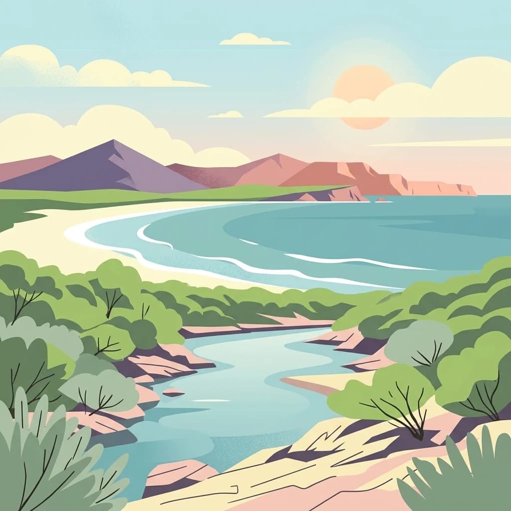
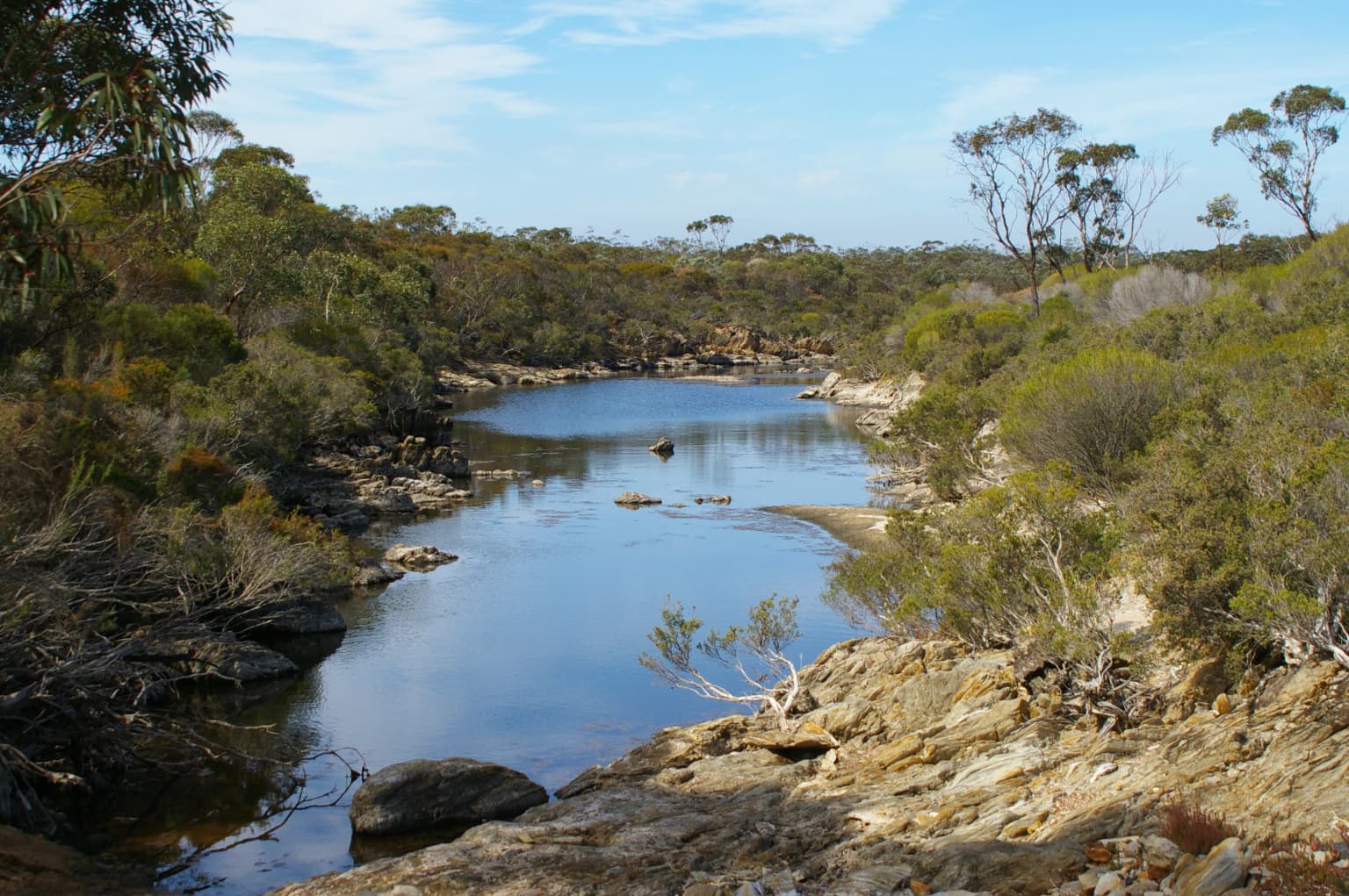
The topography of Fitzgerald River National Park is characterised by a remarkable diversity of landforms within a relatively compact area. The Barren Range rises sharply from the surrounding plains, with East Mount Barren, Middle Mount Barren, and West Mount Barren forming prominent peaks that dominate the park's interior. These ancient ranges are composed of weathered granite and laterite, with exposed rock faces and steep ridges creating dramatic scenery. The Eyre Range provides additional elevation and visual definition to the western portions of the park. Between these ranges, the Fitzgerald River and Hamersley River have carved valleys that carry seasonal flows inland to estuaries including Culham Inlet and Hamersley Inlet. The coastal zone features cliff faces, sandy beaches, and sheltered coves, with Point Ann offering panoramic views over the Southern Ocean. Inland areas give way to extensive plains and dunes, with the landscape transitioning between coastal heath, mallee woodland, and scrubland communities.

Fitzgerald River National Park

Fitzgerald River National Park ecosystems, habitats, and plant life

The ecological character of Fitzgerald River National Park is defined by its location within one of the world's biodiversity hotspots. The Mediterranean-climate of southwestern Australia has produced extraordinarily diverse plant communities, and the park protects representative examples of virtually all major habitat types found in the region. The park's floral inventory documents 1,748 plant taxa, a figure that places it among the most species-rich areas on the planet relative to its size. Approximately 250 species within the park are considered rare or restricted in distribution, while 75 species are endemic and found nowhere else on Earth. Vegetation communities range from coastal heath and dune systems through to mallee woodlands, shrublands, and the distinctive kwongan heath that dominates much of the sandplain country. The Fitzgerald Biosphere designation by UNESCO recognises the park's role as an internationally significant example of sustainable development and conservation in a Mediterranean-climate ecosystem.

Fitzgerald River National Park DSC04436.JPG

Fitzgerald River National Park wildlife and species highlights

Fitzgerald River National Park supports a remarkable assembly of fauna despite its relatively harsh Mediterranean environment. Twenty-two mammal species have been recorded within the park, including several that are rare or threatened. The dibbler and heath mouse were both thought to be extinct before being rediscovered in the region, while the tammar wallaby and woylie occupy mallee and heath habitats throughout the park. The quenda, chuditch, and red-tailed phascogale represent additional marsupial species adapted to the park's diverse habitats. Birdlife is particularly diverse, with over 200 species recorded including the western bristlebird, western ground parrot, and western whipbird which are among the more restricted species found here. The park is recognised as an Important Bird Area, with the endangered malleefowl known to nest in the park's woodlands. Reptiles are well-represented with 41 species, while 12 frog species inhabit the wetlands and watercourses. Coastal and wetland areas provide critical habitat for migratory birds including the white-bellied sea eagle, Pacific swift, and Caspian tern.

Fitzgerald River National Park Homestead

Fitzgerald River National Park conservation status and protection priorities

The conservation significance of Fitzgerald River National Park cannot be overstated, as it represents one of the most important protected areas in Australia for biodiversity preservation. Its listing on Australia's National Heritage List recognises outstanding universal values, particularly the extraordinary concentration of endemic plant species. The park contains approximately 20 percent of Western Australia's described plant species despite occupying only 0.2 percent of the state's land area, making it a repository of evolutionary heritage of global importance. As a UNESCO Biosphere Reserve, the park serves dual roles in biodiversity conservation and sustainable land management. Several plant species within the park are classified as endangered, including Boronia clavata with only around 100 individuals remaining across five populations, and the barrens wedding bush and fan-leaf grevillea. Management challenges include controlling the spread of Phytophthora cinnamomi root rot, which has led to restrictions on access to many of the park's peaks to prevent disease transmission.

Fitzgerald River National Park cultural meaning and human context

Fitzgerald River National Park lies within the traditional country of the Goreng, Mineng, and Wudjari peoples of the Noongar Aboriginal nation, whose cultural connections to this landscape extend deep into prehistory. The Noongar people have inhabited the southern coast of Western Australia for tens of thousands of years, with the park's rivers, ranges, and coastal areas holding significant cultural and spiritual meaning. European settlement of the region began in the early nineteenth century, introducing pastoralism to lands that had been managed by Indigenous fire practices for millennia. The Quaalup Homestead, built in 1858, represents the surviving physical legacy of early European settlement in the region and now operates as a wilderness retreat. Historical accounts, including writings by Ethel Hassell in the late nineteenth century, document both the landscape and the interactions between early settlers and Noongar people in the area.

Top sights and standout views in Fitzgerald River National Park

Fitzgerald River National Park offers visitors exceptional experiences centred on its outstanding natural values. The park is one of only two locations in Australia where southern right whales come to calve, with Point Ann providing optimal whale watching opportunities during the winter months. The Barren Range peaks, particularly West Mount Barren, offer challenging hikes with spectacular panoramic views across the park and coastline. The botanical displays are particularly impressive in spring when wildflowers transform the heathlands into carpets of colour featuring royal hakea, Qualup bell, scarlet banksia, and numerous featherflower species. The Quaalup Homestead provides a historical window into nineteenth-century pastoral life in the region. Four-wheel-drive tracks provide access to the more remote areas of the park, while the multi-day walk between Bremer Bay and Hopetoun showcases the park's diverse landscapes.

Best time to visit Fitzgerald River National Park

The optimal time to visit Fitzgerald River National Park depends on the experience sought, though the spring months from September to November generally offer the most favourable conditions for exploring the park's natural wonders. During this period, wildflower displays reach their peak, with the kwongan heath and mallee communities producing spectacular displays of colour as numerous species flower in succession. The weather is typically mild with comfortable daytime temperatures for hiking and outdoor activities. Winter, from June to August, brings the southern right whale migration, with pregnant cows arriving at Point Ann to give birth in the sheltered coastal waters. This period can be wet and cold, but offers unique wildlife viewing opportunities that draw dedicated whale watchers. Summer months can be hot and dry, limiting some activities but providing opportunities for coastal recreation and beach exploration. The park can be visited year-round, though summer temperatures may make strenuous hiking uncomfortable and some inland roads may become impassable after rains.

Park location guide

Geography guide, regional context, and park location map for Fitzgerald River National Park

Fitzgerald River National Park park geography, regions, and map view in Australia
Understand where Fitzgerald River National Park sits in Australia through a broader geographic reading of the surrounding landscape, nearby location context, and its mapped position within the national park landscape.

How Fitzgerald River National Park fits into Australia

Australia is a constitutional monarchy and federal parliamentary democracy comprising six states and ten territories. With a population of nearly 28 million, it is one of the world's most urbanised countries, with most people concentrated on the eastern seaboard. The country has a high Human Development Index and is known for its cultural diversity, ancient Aboriginal heritage, and unique wildlife.

Wider geography shaping Fitzgerald River National Park in Australia

Australia occupies the entire Australian continent, the island of Tasmania, and numerous smaller islands. It is the world's flattest and driest inhabited continent, featuring vast deserts in the interior (the Outback), tropical rainforests along the eastern coast, and a coastline bordering the Indian and Pacific Oceans.

Map view of Fitzgerald River National Park

Use this park location map to pinpoint Fitzgerald River National Park in Australia, understand its exact geographic position, and read its mapped placement within the surrounding landscape more clearly.

Pigeon | © OpenStreetMap contributors

Location context for Fitzgerald River National Park

Shire of JerramungupShire of RavensthorpeWestern Australia

Visualize the park's extraordinary botanical diversity, rugged mountain ranges, and dynamic coastal environments through detailed imagery.

Fitzgerald River National Park Photos: Explore Diverse Protected Landscapes and Coastal Scenery
Visually explore Fitzgerald River National Park, a globally significant protected area showcasing extraordinary plant diversity, ancient mountain ranges, and vital coastal habitats. Reviewing its detailed imagery helps unravel the complex interplay of terrain, vegetation, and coastal features, offering a deeper understanding of this unique Australian conservation landscape.

Fitzgerald River National Park, Royal hakea

Fitzgerald River National Park from Point Ann

Fitzgerald River National Park

Fitzgerald River National Park DSC04436.JPG

Fitzgerald River National Park Homestead

Gairdner River, Fitzgerald River National Park

Park atlas

Compare regional protected landscapes and trace the geographic spread of parks in Western Australia.

Discover Other National Parks and Protected Areas Near Fitzgerald River National Park
Browse national parks and protected areas geographically connected to Fitzgerald River National Park, covering diverse coastal, mountain, and heathland conservation landscapes. Expand your atlas-style discovery by comparing these protected entities and understanding their regional context within Western Australia's unique natural terrain.
National parkWestern Australia

Porongurup National Park: Ancient Granite Peaks and Karri Forest Protected Landscape

Mapped terrain and geologic history in Western Australia.

Delve into Porongurup National Park, a protected landscape in Western Australia characterized by its ancient, billion-year-old granite peaks and a rare outlier of towering karri forest. This national park offers a unique geographic perspective, showcasing dramatic mountain terrain that has stood for eons. Explore the mapped boundaries and the distinct ecosystems that thrive within this ancient mountain system, providing rich context for regional atlas discovery and understanding the park's geological significance.

Area
26.21 km²
Established
1971
IUCN
II
National parkWestern Australia

West Cape Howe National Park: Western Australia's Southernmost Coastal Protected Landscape

Explore dramatic sea cliffs, ancient karri forests, and Torbay Head.

West Cape Howe National Park offers a distinct protected landscape experience in Western Australia, highlighted by its position at mainland Australia's southernmost point, Torbay Head. This park showcases a rugged 23-kilometer stretch of the Southern Ocean coastline, featuring towering sea cliffs that descend to pristine beaches and rocky shores. Inland, visitors find ancient karri forests and diverse vegetation types, contributing to a rich mosaic of protected habitats. Its geographic significance and unique coastal terrain make it a key destination for understanding regional protected area geography.

Area
36.05 km²
Established
1985
IUCN
II
Relief
Lowland
National parkWestern Australia

Lake Muir National Park: A Ramsar-Listed Wetland National Park in Western Australia

Explore mapped boundaries and the unique paperbark woodland landscapes.

Lake Muir National Park protects a significant portion of the Muir-Byenup System, a Ramsar-designated wetland complex in Western Australia's south-west. This national park serves as a vital habitat for waterbirds and features characteristic paperbark woodlands surrounding the large inland Lake Muir. Understanding its protected area status and mapped geographic features provides crucial insight into the region's ecological importance.

Area
96.36 km²
Established
2004
IUCN
II
National parkWestern Australia

Mount Frankland National Park: Explore Western Australia's Old-Growth Forested Landscape

Granite peaks and unique regional geography within a protected wilderness area.

Mount Frankland National Park in Western Australia is a protected area renowned for its exceptional old-growth karri and red tingle forests, some of the world's tallest tree species. The park's landscape is shaped by low granite hills and dramatic peaks, including the 411-meter Mount Frankland, offering expansive views across the wilderness. As a key component of the Walpole Wilderness Area, this national park provides a rich geographical context for understanding conservation and mapped natural landscapes in Southwest Australia.

Area
373.59 km²
Established
1988
IUCN
II
National parkSouth West

Jane National Park: Old-Growth Forest Protected Landscape and Regional Geography

Mapped terrain and ancient ecosystems of Western Australia.

Jane National Park stands as a vital protected area safeguarding some of Western Australia's last remaining old-growth forests. Located in the South West region, this national park preserves centuries-old karri trees and rich forest ecosystems within the Warren bioregion. Its mapped expanse offers insights into the region's natural terrain and the importance of conserving these rare, undisturbed landscapes for future exploration and understanding.

Area
68.63 km²
Established
2004
IUCN
II
National parkWestern Australia

Warren National Park: A Protected Landscape of Ancient Karri Forests in Western Australia

Explore mapped forest boundaries and river geography.

Warren National Park offers an unparalleled glimpse into the grandeur of old-growth karri forests, showcasing some of Western Australia's most towering trees. Situated in the South West region, this national park protects a vital tract of temperate forest ecosystem, characterized by rolling terrain and the scenic Warren River. Its mapped landscape and protected-area status highlight the critical importance of preserving these magnificent natural environments for atlas-based geographic discovery.

Area
29.81 km²
Established
1977
IUCN
II
National parkWestern Australia

Wellington National Park: Protected Jarrah Forest & Collie River Landscape

Explore the mapped boundaries and regional geography.

Wellington National Park offers a deep dive into Western Australia's protected landscapes, characterized by extensive old-growth jarrah forests and the scenic Collie River valley. This national park provides a vital study of the region's unique geography, mapped terrain, and ecological significance within the Yilgarn craton. Understand the park's protected area identity and its place in the wider natural context of Western Australia through its detailed landscape features.

Area
170 km²
Established
2000
IUCN
II
National parkWestern Australia

Cape Arid National Park: A National Park Atlas Entry for Western Australia's Coast

Explore its mapped terrain and protected landscape identity.

Cape Arid National Park, located in Western Australia, is a substantial protected area notable for its striking coastal geography. This national park features a dramatic intersection of the Southern Ocean coastline with ancient granite landforms and low hills, creating a diverse mapped terrain. Its significance extends to being a key habitat for numerous bird species, making it a critical component of the regional protected-area network and a valuable point of study within the broader geographic atlas.

Area
2,794.46 km²
Established
1969
IUCN
II
Relief
Mixed relief

Common questions about visiting, size, designation, and location context for Fitzgerald River National Park

Fitzgerald River National Park FAQs for park facts, access, geography, and protected area context
Find quick answers about Fitzgerald River National Park, including protected-area facts, park geography, trail and visitor context, and how the park fits into its surrounding country and regional landscape.
MoriAtlas Explorer

Continue Your Protected Areas Search Across the Global Atlas

Deepen your exploration by continuing the structured search for national parks and protected areas worldwide. Utilize the comprehensive filtering capabilities to compare different conservation landscapes and refine your understanding of global park geography. Discover more about the distribution and characteristics of protected natural areas.

Global natural geography