Mori Atlas logo
National parkWest Cape Howe National Park

Discover a rugged 23-kilometer stretch of Southern Ocean coastline and ancient karri forests.

West Cape Howe National Park: Southernmost Mainland Tip and Dramatic Coastal Atlas

West Cape Howe National Park represents a significant protected landscape within Western Australia, defined by its unique position as mainland Australia's southernmost point at Torbay Head. This atlas-oriented page details the park's dramatic coastal geography, where rugged sea cliffs and pristine beaches meet ancient karri forests. Users can explore the mapped boundaries and distinct ecological zones, from coastal heath to wetland environments, contributing to a richer understanding of regional protected area distribution.

Coastal national parksKarri forest ecosystemsSouthern Ocean coastlineWestern Australia protected areasBirdwatching locationsGreat Southern region
Illustration showing a coastal scene with sandy beach, blue ocean, green hills, mountains, and pink clouds under a bright sun

West Cape Howe National Park

National park

Park overview

Structured park overview, official facts, and landscape profile for West Cape Howe National Park

West Cape Howe National Park park facts, protected area profile, and essential visitor context
Review the core facts for West Cape Howe National Park, including designation, size, terrain, visitor scale, habitats, and operating context in one park-focused overview.

About West Cape Howe National Park

West Cape Howe National Park occupies a remarkable position at the southernmost extent of the Western Australian coastline, where the mainland reaches its greatest southern latitude. The park protects a diverse array of coastal and forest environments within the Great Southern region, approximately midway between Albany and Denmark. The park's coastline is characterised by dramatic sea cliffs, accessible beaches, and the powerful Southern Ocean surf that shapes the shoreline. Torbay Head, rising prominently within the park, serves as a navigational landmark and represents the southernmost point of the Australian continent's mainland, making it a location of geographic significance that attracts visitors seeking to reach this continental extremity. The interior of the park transitions from coastal heath through to the towering karri forests that are a hallmark of the south-west of Western Australia, with these ancient trees reaching remarkable heights in the sheltered valleys. The park provides habitat for several notable species including the endemic Albany Pitcher Plant, a carnivorous species specialised to the region's moist habitats, and the rare Main's assassin spider, a threatened arachnid that represents an ancient lineage.

Quick facts and research context for West Cape Howe National Park

West Cape Howe National Park was established in 1985 and covers approximately 36.05 square kilometres along the Southern Ocean coast in the Great Southern region of Western Australia. The park is managed by the Department of Parks and Wildlife and is located within the City of Albany local government area. Torbay Head, the southernmost point of the Australian mainland, is a prominent geographic feature within the park. The area features a combination of karri forest, coastal heath, and wetland habitats, with Lake William supporting particularly dense sedge scrub and rare plant species. The Bibbulmun Track, Western Australia's long-distance walking trail, traverses the park providing important visitor access.

Park context

Deeper park guide and search-rich context for West Cape Howe National Park

West Cape Howe National Park history, landscape, wildlife, and travel context
Explore West Cape Howe National Park through its history, landscape character, ecosystems, wildlife, conservation priorities, cultural context, and seasonal travel timing in a structured park guide built for atlas discovery and search intent.

Why West Cape Howe National Park stands out

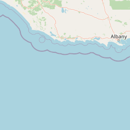
West Cape Howe National Park is best known for marking the southernmost tip of the Australian mainland at Torbay Head, a geographic landmark of considerable significance. The park is renowned for its dramatic coastal scenery, where towering sea cliffs meet the Southern Ocean along a rugged 23-kilometre stretch of coastline. The combination of ancient karri forest descending directly to the coast creates a distinctive landscape rare in Western Australia. The park also protects populations of the Albany Pitcher Plant, a carnivorous plant species endemic to this region, and the rare Main's assassin spider, a threatened species discovered during a 2008 survey.

Coastal landscape with turquoise ocean, white sandy beach, green hills, and rocky headland
View across Shelley Beach to West Cape Howe National Park

West Cape Howe National Park history and protected-area timeline

The land that now forms West Cape Howe National Park began its path toward protection in 1977 when it was vested in the Shire of Albany for recreational purposes. In 1985, following negotiations between the shire and the National Parks and Nature Conservancy Authority, the area was gazetted as a C Class Reserve, formalising its protected status. The park received additional protection in 1987 when an adjacent timber reserve along the northern boundary, comprising 41 hectares, was incorporated into the park and its status elevated to A Class. This expansion brought the total area to approximately 3,517 hectares, creating a single consolidated reserve. Scientific surveys conducted in 2008 resulted in the discovery of Main's assassin spider within the park, a rare and ancient species now listed as threatened, demonstrating the park's ongoing significance for biodiversity conservation.

West Cape Howe National Park landscape and geographic character

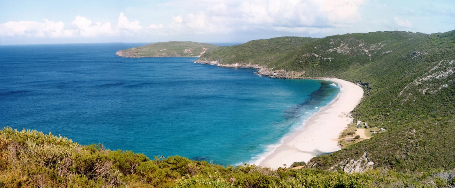
The landscape of West Cape Howe National Park is defined by the dramatic intersection of forest and ocean along the Southern Ocean coast. The park encompasses approximately 23 kilometres of coastline featuring sea cliffs that rise above beaches and rocky headlands, with Torbay Head standing as the most prominent coastal landmark. The park extends inland from the coast through a sequence of vegetation communities, from coastal heath on the more exposed slopes through to the towering karri forest that occupies the deeper valleys and sheltered aspects. Lake William in the park's interior supports a distinct wetland environment with dense sedge scrub, adding ecological and visual diversity to the park's landscape character. The contrast between the ancient, vertical forms of karri trees and the horizontal sweep of the Southern Ocean creates a visually striking environment characteristic of the Great Southern coast.

West Cape Howe National Park ecosystems, habitats, and plant life

The park protects a valuable mosaic of Australian southwest ecosystems, including karri forest, coastal heath, and wetland habitats. The karri forests represent one of the tallest forest types in the world, with these eucalyptus trees capable of reaching heights exceeding 60 metres in favourable conditions. The coastal heath community dominates the more exposed coastal slopes and supports specialised plant adaptations to salt-laden winds and sandy soils. Around Lake William, dense sedge scrub creates a different environmental character, supporting species adapted to permanent moisture including rare and undescribed plant taxa. The Albany Pitcher Plant, found within the park, represents a carnivorous plant species endemic to the southwest of Western Australia, occurring in moist habitats where nutrient-poor soils favour alternative nutrition strategies.

West Cape Howe National Park wildlife and species highlights

The park's diverse habitats support corresponding diversity in wildlife, with the 2008 discovery of Main's assassin spider representing a particularly significant finding. This ancient arachnid species, belonging to the family Archaeidae, is listed as threatened and represents one of Australia's most primitive spider lineages. The combination of forest, heath, and wetland habitats provides resources for a range of bird species, mammals, and invertebrates, though detailed species inventories are limited in the source material. The coastal position of the park also places it within important bird migration pathways along the southern Australian coast, though specific migratory species are not detailed in the available sources.

West Cape Howe National Park conservation status and protection priorities

West Cape Howe National Park contributes significantly to the conservation estate in the Great Southern region of Western Australia, protecting representative examples of coastal, forest, and wetland ecosystems. The discovery of the threatened Main's assassin spider during a 2008 survey demonstrates that the park continues to yield important biodiversity discoveries and serves as a refuge for species of conservation concern. The protection of Torbay Head, as the southernmost point of the mainland, preserves a location of geographic significance while the park's multiple habitat types ensure protection of ecological communities ranging from coastal heath through to tall karri forest. The A Class reserve status provides the highest level of protection within the Western Australian conservation system.

Top sights and standout views in West Cape Howe National Park

The southernmost point of mainland Australia at Torbay Head stands as the park's signature attraction, drawing visitors to this geographic extremity. The Bibbulmun Track, Western Australia's premier long-distance walking trail, passes through the park and provides access to Torbay Head via a 15-kilometre return spur trail, while an overnight shelter near West Cape Howe accommodates hikers on extended treks. Shelley Beach offers a more accessible destination for all vehicles, complete with campground facilities, lookouts, and hang-gliding launch sites. The park's combination of karri forest descending directly to cliff edges above the Southern Ocean creates visual drama uncommon along the Western Australian coast, while the presence of the rare Albany Pitcher Plant adds botanical significance.

Best time to visit West Cape Howe National Park

The park can be visited year-round, though the southern summer months from December through March typically offer the most comfortable conditions for walking and beach activities. Winter rainfall sustains the wetland areas and keeps the karri forests verdant, though some tracks may be softer underfoot and the weather more variable. The coastal location means that wind is a constant consideration, with stronger conditions common during the winter months. Summer provides longer daylight hours for walking the Bibbulmun Track and exploring the park's various attractions, while the cooler months may suit those seeking a quieter experience with the forests at their greenest.

Park location guide

Geography guide, regional context, and park location map for West Cape Howe National Park

West Cape Howe National Park park geography, regions, and map view in Australia
Understand where West Cape Howe National Park sits in Australia through a broader geographic reading of the surrounding landscape, nearby location context, and its mapped position within the national park landscape.

How West Cape Howe National Park fits into Australia

Australia is a constitutional monarchy and federal parliamentary democracy comprising six states and ten territories. With a population of nearly 28 million, it is one of the world's most urbanised countries, with most people concentrated on the eastern seaboard. The country has a high Human Development Index and is known for its cultural diversity, ancient Aboriginal heritage, and unique wildlife.

Wider geography shaping West Cape Howe National Park in Australia

Australia occupies the entire Australian continent, the island of Tasmania, and numerous smaller islands. It is the world's flattest and driest inhabited continent, featuring vast deserts in the interior (the Outback), tropical rainforests along the eastern coast, and a coastline bordering the Indian and Pacific Oceans.

Map view of West Cape Howe National Park

Use this park location map to pinpoint West Cape Howe National Park in Australia, understand its exact geographic position, and read its mapped placement within the surrounding landscape more clearly.

Pigeon | © OpenStreetMap contributors

Location context for West Cape Howe National Park

Western Australia

Trace the visual character of its rugged Southern Ocean coastline, ancient karri forests, and diverse protected environments.

West Cape Howe National Park Photos: Coastal Landscapes, Karri Forest, and Protected Scenery
Browse a visual collection of West Cape Howe National Park imagery to understand its dramatic coastal landscapes, unique karri forest ecosystems, and the rugged terrain surrounding Torbay Head. This gallery offers essential visual context for appreciating the park's protected environments, diverse habitats, and distinct character along Western Australia's Southern Ocean coastline.

Coastal landscape with turquoise ocean, white sandy beach, green hills, and rocky headland

Park atlas

Explore the Diverse Protected Landscapes and Coastal Geography Surrounding West Cape Howe National Park in Western Australia

Discover Other National Parks and Protected Areas Near West Cape Howe National Park
Continue your geographic exploration beyond West Cape Howe National Park by browsing other national parks and protected areas across Western Australia's Great Southern region. Compare diverse coastal landscapes, karri forest ecosystems, and unique conservation sites to understand the broader regional park geography.
National parkWestern Australia

Torndirrup National Park National Park: Mapped Boundaries and Regional Landscape Context

Explore protected lands within Western Australia's geography.

Torndirrup National Park serves as a significant protected natural area, offering valuable insights into the geographic character of Western Australia. This detailed entry focuses on its mapped boundaries and its role as a protected landscape, providing essential context for atlas-based exploration of Australia's diverse regions and natural terrains.

Area
39.36 km²
Established
1918
IUCN
II
Visitors
250K annual
National parkGreat Southern

Mount Lindesay National Park: Australian National Park Protected Landscape Details

Explore mapped boundaries and regional geographic context in Great Southern.

Gain a structured understanding of Mount Lindesay National Park, a designated national park in Australia's Great Southern region. This detail view focuses on its protected landscape identity, mapped geographic features, and its place within the nation's network of conservation areas. Discover the specific terrain and regional atlas context that makes this park a distinct element of Australia's natural geography.

Area
395.73 km²
Established
2004
IUCN
II
Relief
Mountain
Watercolor illustration of a coastal landscape with green vegetation, pink rock formations, and a calm body of water
National parkWestern Australia

William Bay National Park: Mapped Protected Area in Western Australia's Geography

Explore its national park boundaries and regional landscape context.

Delve into the protected landscape of William Bay National Park, a designated national park situated within the diverse geography of Western Australia. This resource provides critical information on its mapped boundaries and its role as a protected natural area. Understand the park's specific geographic setting and its contribution to the regional atlas of conservation landscapes, essential for detailed park and landscape discovery.

Area
17.34 km²
Established
1971
IUCN
II
Visitors
238K annual
National parkWestern Australia

Gull Rock National Park: Protected Landscape and Geographic Atlas Exploration

Discover mapped boundaries and natural terrain in Western Australia.

Gull Rock National Park serves as a key protected area for exploring the geographic diversity of Western Australia. As a national park, it offers a focal point for understanding mapped landscape features, conservation boundaries, and the unique natural terrain of the region. This entry provides essential context for atlas-based discovery of protected lands across Australia.

Area
21.04 km²
Established
2006
IUCN
II
Relief
Lowland
National parkWestern Australia

Porongurup National Park: Ancient Granite Peaks and Karri Forest Protected Landscape

Mapped terrain and geologic history in Western Australia.

Delve into Porongurup National Park, a protected landscape in Western Australia characterized by its ancient, billion-year-old granite peaks and a rare outlier of towering karri forest. This national park offers a unique geographic perspective, showcasing dramatic mountain terrain that has stood for eons. Explore the mapped boundaries and the distinct ecosystems that thrive within this ancient mountain system, providing rich context for regional atlas discovery and understanding the park's geological significance.

Area
26.21 km²
Established
1971
IUCN
II
Relief
Mountain
National parkGreat Southern

Mount Roe National Park: Detailed Protected Landscape and Geographic Exploration

Mapped boundaries and natural terrain of this national park.

Mount Roe National Park offers a distinct protected landscape for atlas exploration, situated within the geographic scope of the Great Southern region. This detail page provides a structured view of the park's mapped boundaries and its natural terrain. Understand how Mount Roe National Park contributes to the regional geography and the overall map of protected areas in Australia.

Area
1,278 km²
Established
2004
IUCN
II
Scope
Terrestrial
National parkWestern Australia

Waychinicup National Park: National Park Protected Landscape Atlas Entry

Explore Western Australia's mapped natural landscapes and park geography.

Gain a structured understanding of Waychinicup National Park as a key protected landscape within Western Australia. This detailed atlas entry focuses on its geographic distribution and mapped boundaries, providing essential context for regional park and natural landscape exploration. Discover the unique characteristics of this national park's setting and its place within the broader mapped terrain.

Area
39.82 km²
Established
1990
IUCN
II
Relief
Mixed relief
National parkWestern Australia

Walpole-Nornalup National Park: Explore Protected Landscape and Regional Geography

Mapped boundaries and natural terrain context in Western Australia.

Walpole-Nornalup National Park offers a focused lens for understanding protected landscapes. As a designated national park in Western Australia, it provides valuable insights into regional geography and mapped natural terrain. This detailed view allows for a clear appreciation of the park's specific protected area characteristics and its place within the larger geographic atlas of the state.

Area
194.48 km²
Established
1910
IUCN
II
Visitors
158.2K annual

Common questions about visiting, size, designation, and location context for West Cape Howe National Park

West Cape Howe National Park FAQs for park facts, access, geography, and protected area context
Find quick answers about West Cape Howe National Park, including protected-area facts, park geography, trail and visitor context, and how the park fits into its surrounding country and regional landscape.
MoriAtlas Explorer

Continue Your Protected Areas Search Across the Global Atlas

Deepen your exploration by continuing the structured search for national parks and protected areas worldwide. Utilize the comprehensive filtering capabilities to compare different conservation landscapes and refine your understanding of global park geography. Discover more about the distribution and characteristics of protected natural areas.

Global natural geography