Mori Atlas logo
National parkKahurangi National Park

Discover the mapped protected boundaries and exceptional geographic diversity of this West Coast Region natural treasure.

Kahurangi National Park: New Zealand's Second Largest National Park with Unrivalled Paleozoic Geology and Karst Landscapes

Kahurangi National Park, situated in the northwest of New Zealand's South Island within the West Coast Region, stands as a monumental protected landscape. This expansive national park, covering 5,193 square kilometers, is celebrated for its unparalleled geological complexity, featuring the most complete sequence of Paleozoic rocks in New Zealand and extensive karst formations. Beyond its ancient geology, Kahurangi offers an extraordinary mosaic of terrains, from rugged mountain ranges and deep river valleys to elevated peneplains and coastal cliffs, making it a vital area for atlas-driven geographic discovery.

Alpine EnvironmentsBirdwatchingCavingCoastal SceneryEndemic SpeciesGeological Heritage

Kahurangi National Park

National park

Park overview

Structured park overview, official facts, and landscape profile for Kahurangi National Park

Kahurangi National Park park facts, protected area profile, and essential visitor context
Review the core facts for Kahurangi National Park, including designation, size, terrain, visitor scale, habitats, and operating context in one park-focused overview.

About Kahurangi National Park

Kahurangi National Park stands as one of New Zealand's most distinctive protected areas, not for a single iconic landmark but for the extraordinary diversity of its landscapes, geology, and ecological systems. The park occupies much of the northwest corner of the South Island, a region where complex geological processes have created an exceptionally varied terrain. The ancient basement rocks dominating the landscape represent some of the oldest in New Zealand, with the Buller and Tākaka terranes forming the geological foundation. These Paleozoic formations have been shaped by hundreds of millions of years of tectonic activity, glaciation, and erosion to produce the present-day landscape of mountain ranges, river valleys, gorges, uplifted peneplains, and dramatic karst topography. The park's ecological character is equally significant. Positioned as a biogeographic refuge during the Pleistocene ice ages, the area retained species and allowed evolution to continue in relative isolation. This historical context explains the extraordinary level of endemism found within the park's boundaries, with over half of New Zealand's native plant species represented here, including sixty-seven species found nowhere else on Earth. The park's value was recognized even in the early twentieth century, with the Gouland Downs designated as a sanctuary in 1915. The establishment of the national park in 1996 followed decades of advocacy, particularly from the Maruia Society environmental lobby group, and represented a significant expansion of New Zealand's protected area network. Management by the Department of Conservation continues to balance conservation values with recreation opportunities, including the maintenance of the Heaphy Track, Wangapeka Track, and other multi-day tramping routes that allow visitors to experience the park's diverse environments.

Quick facts and research context for Kahurangi National Park

Kahurangi National Park spans 5,193 square kilometres in the northwest South Island, making it New Zealand's second-largest national park. The park was gazetted in 1996, largely formed from the former North-west Nelson Forest Park and the Tasman Wilderness Area. Its geological foundation consists of Paleozoic Buller and Tākaka terranes, separated by the Anatoki Fault, representing the country's most diverse and oldest rock sequences. The park receives high annual rainfall, with western exposures and higher elevations receiving up to 6,000 millimetres annually, creating steep rivers and forested catchments. Notable features include the Heaphy Track (one of New Zealand's Great Walks), the Ōpārara Basin with its famous natural arch, the Mount Arthur Tablelands, and extensive cave systems including Nettlebed Cave, the Southern Hemisphere's deepest known cave system at 1,180 metres.

Park context

Deeper park guide and search-rich context for Kahurangi National Park

Kahurangi National Park history, landscape, wildlife, and travel context
Explore Kahurangi National Park through its history, landscape character, ecosystems, wildlife, conservation priorities, cultural context, and seasonal travel timing in a structured park guide built for atlas discovery and search intent.

Why Kahurangi National Park stands out

Kahurangi National Park is best known for its exceptional geological diversity, containing the finest sequence of Paleozoic rocks in New Zealand and extensive karst landscapes with some of the Southern Hemisphere's longest and deepest cave systems. The park protects remarkable biodiversity, including eighty percent of New Zealand's alpine plant species and numerous endemic species found nowhere else on Earth. It features the renowned Heaphy Track, a Great Walk that traverses diverse landscapes from coastal nikau palm groves to alpine tussock grasslands. The park's landscapes also served as filming locations for The Lord of the Rings trilogy, with Mount Owen and Mount Olympus featured in the productions.

Mt Patriarch from Wangapeka Track
View of Wangapeka River and Mt Patriarch from Wangapeka Track in Kahurangi National Park, New Zealand.

Kahurangi National Park history and protected-area timeline

The human history of Kahurangi National Park extends back to around 1380 CE when Māori settled the coastline, establishing pa sites on coastal ridges and more substantial settlements at river mouths and estuaries. The Anaweka waka, discovered near the park's western boundary and dating from around 1226 CE, represents one of only two long-distance voyaging canoes known to have survived to modern times. For much of the region's history, Ngāti Tūmatakōkiri held mana whenua over the area after arriving from the western North Island in the early 1600s, maintaining dominance for approximately 200 years before other iwi encroached in the early 1800s. European exploration began with sealers in the early nineteenth century, who nearly exterminated seal colonies within two decades. Following the establishment of Nelson in 1841, timber, flax, and coal resources were exploited throughout the region. The discovery of gold in stream beds on the Mount Arthur Tableland by Thomas Salisbury in 1863 triggered a gold rush, while his brother John grazed sheep in the area from 1875. The unique flora and fauna of the region received early recognition, with the Gouland Downs designated as a sanctuary in 1916 and 16,000 acres of Crown land reserved under the Scenery Preservation Act 1903. In 1970, approximately 360,000 hectares were gazetted as the North-west Nelson Forest Park, and the Forest Service began developing tracks and facilities. The Maruia Society advocated for national park status from the 1980s, and in 1987 management transferred to the newly formed Department of Conservation. The Tasman Wilderness Area was designated in 1988, and after recommendation by the Conservation Authority in 1993, Kahurangi National Park was finally established in 1996. The establishment process excluded various areas for mining, hydro-electric development, grazing, and pending Treaty of Waitangi claims. Additional parcels totaling 900 hectares were added in 2016, and in 2019, 64,400 hectares of the Mōkihinui River catchment were incorporated, increasing the park's size by fourteen percent.

Kahurangi National Park landscape and geographic character

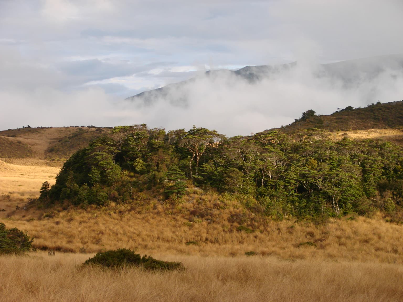
The landscape of Kahurangi National Park is characterized by remarkable diversity rather than a single dominant landform. The western boundary follows the Heaphy Track route along the coastline from the Kōhaihai River past Scotts Beach to the mouth of the Heaphy River, then continues to Kahurangi Point, known for its steep cliffs. The coastal strip features nearly unmodified terrain with a narrow but highly diverse coastal forest including nikau palms, New Zealand's only native palm species. The park's interior encompasses several distinct landscape zones. The Gouland Downs is a tussock-covered basin at approximately 600 metres elevation, surrounding by forest and representing a peneplain formed from prolonged erosion of Lower Paleozoic sandstones and mudstones. Limestone deposited during a shallow sea transgression was subsequently uplifted and largely eroded, leaving isolated tree-covered outcrops rising from the tussock like islands. The Cobb Valley supports montane forests on ancient volcanics and ultramafics, with beech and conifer-beech forests, valley floor scrub, and sub-alpine grasslands surrounding alpine lakes and the Cobb Reservoir. The Mount Arthur Tablelands to the west of Mount Arthur present a rolling landscape of tussock and karst features at around 1,200 metres elevation, surrounded by peaks including Mount Lodestone, Mount Arthur, and Mount Peel. The Ōpārara Basin at approximately 200 metres elevation is covered in dense forest and contains New Zealand's largest natural arch, the Ōpārara Arch at 200 metres in length and 37 metres in height. The park's geology includes the oldest fossils found in New Zealand, trilobites from the Cambrian period discovered in the Cobb Valley in 1948.

Moria Gate Arch SM2014.jpg
Moria Gate Arch, Oparara Basin

Kahurangi National Park ecosystems, habitats, and plant life

The ecological character of Kahurangi National Park is defined by extraordinary diversity and high levels of endemism, a result of the region's geological complexity and its role as a biogeographic refuge during the Pleistocene ice ages. The park contains over half of New Zealand's approximately 2,400 native plant species, including sixty-seven species found nowhere else on Earth. This botanical diversity is distributed across varied habitats from coastal forest through beech and podocarp forests to alpine tussock grasslands and fellfield. The park hosts eighty percent of all New Zealand's alpine species, a proportion that reflects both the variety of alpine habitats present and the long period of isolation that allowed speciation to proceed. The complex geology has created localized environments supporting unique plant communities, with different rock types producing distinct soil conditions that in turn support different vegetation patterns. Notable endemic plants include the Kahurangi pittosporum, several species of Celmisia, Dracophyllum, and Gentianella, as well as specialized species adapted to limestone and marble substrates in the karst areas. The park's freshwater systems are equally significant, with the Karamea River catchment representing twenty-three percent of the park's total area and supporting distinct aquatic communities.

Lake Sylvester sunrise
Lake Sylvester during sunrise, near Iron Lake, looking towards Nelson in Kahurangi National Park, New Zealand.

Kahurangi National Park wildlife and species highlights

Kahurangi National Park supports approximately eighteen endemic bird species, representing a significant proportion of New Zealand's avifauna. Notable endemic species include the rock wren, kea, blue duck (whio), great spotted kiwi, and kaka, all classified as either endangered or vulnerable. The park provides critical habitat for whio, with conservation efforts since the late 1990s resulting in a 340% increase in population to 846 adult birds including 335 breeding pairs as of 2023. Other native birds found in the park include pipit, kereru, New Zealand falcon, weka, South Island robin, fantail, bellbird, grey warbler, tui, tomtit, rifleman, fernbird, and brown creeper. Wetland areas support Australasian bittern and New Zealand scaup. The park is also a key habitat for Powelliphanta carnivorous land snails, with twenty-nine of the sixty-four known species endemic to Kahurangi National Park. Both of New Zealand's native bat species, the short-tailed bat and long-tailed bat, have been recorded in the park. Invertebrate diversity is exceptional, including the Mount Arthur giant weta, the Nelson cave spider (the only species in its genus), and numerous cave-dwelling species adapted to the extensive karst systems. A new skink species, Oligosoma kahurangi, was identified in 2021, and new species continue to be discovered, including a flightless cricket in 2023 and a freshwater snail named after Greta Thunberg in 2016.

Gordons Pyramid, Kahurangi National Park
Gordons Pyramid viewed from the Grass Tablelands above Salisbury Hut.

Kahurangi National Park conservation status and protection priorities

Kahurangi National Park represents one of New Zealand's most significant conservation achievements, protecting an area of extraordinary geological and ecological value. The park's biodiversity significance led to its addition to UNESCO's tentative World Heritage list in 2007, alongside Farewell Spit and the Canaan karst system. The Department of Conservation manages the park through multiple Ecosystem Management Units targeting specific catchments and habitats for priority attention. Conservation programs include pest control using 1080 poison to protect native species from rat predation, a controversial but strategically important approach. Takahē, an endangered flightless bird previously extinct from the park for a century, were reintroduced in 2018 with eighteen birds released into the Gouland Downs, though eleven birds died in 2020 possibly related to 1080 poisoning. The whio (blue duck) recovery program has been particularly successful, with population increases of 340% since 2000. The Friends of Flora volunteer group maintains extensive trap lines protecting beech forest and tussockland habitat. The 2019 addition of the Mōkihinui River catchment added 64,400 hectares of relatively unmodified landscape, including podocarp-beech forests and the Old Ghost Road trail corridor. This addition represented a fourteen percent increase in the park's area and filled a significant gap in the protected area network.

Kahurangi National Park cultural meaning and human context

The cultural history of Kahurangi National Park encompasses many centuries of Māori occupation and interaction with the landscape. Archaeological evidence demonstrates coastline settlement from around 1380 CE, with pa sites on coastal ridges and evidence of substantial habitation around river mouths and estuaries. The Anaweka waka, discovered near the park's western boundary and dating from around 1226 CE, is one of only two long-distance voyaging canoes known to have survived to modern times, representing remarkable maritime heritage. The area was rich in food resources, with middens showing evidence of hunting for bush moa, fur seals, and dogs. Trade connections extended throughout New Zealand, with pounamu from the Arahura region and obsidian from Mayor Island reaching the area. Ngāti Tūmatakōkiri held mana whenua over the region from the early 1600s until invasions by Ngāti Apa, Ngāti Kuia, and Ngāi Tahu in the early 1800s. Contemporary iwi with connections to the area include Te Atiawa o Te Waka-a-Māui, Ngāti Rārua, Ngāti Tama, and Ngāi Tahu. The 2019 addition of the Mōkihinui River catchment was marked with the placement of a pouwhenua by Ngāti Waewae and Ngāi Tahu, acknowledging the significance of the area to these iwi.

Dracophyllum traversii mountain neinei flower spikes
Mountain Neinei (Dracophyllum traversii) flower spikes on Mt Arthur in Kahurangi National Park, Aotearoa.

Top sights and standout views in Kahurangi National Park

Kahurangi National Park offers exceptional experiences across its diverse landscapes. The Heaphy Track, one of New Zealand's ten Great Walks, traverses 78.4 kilometres from the northern West Coast to Golden Bay, passing through nikau palm groves, alpine tussock, and beech forest. The Ōpārara Basin features New Zealand's largest natural arch and significant cave systems with paleozoological importance. The Mount Arthur Tablelands present karst and tussock landscapes at alpine elevation. The park contains three of New Zealand's largest cave systems, with Nettlebed Cave reaching 1,180 metres to become the Southern Hemisphere's deepest. Geological features include uplifted mesas, glacial valleys, and extensive karst with natural arches and bluffs. The Gouland Downs sanctuary supports takahē reintroduction. The park's role in The Lord of the Rings films, particularly Mount Owen and Mount Olympus, draws Tolkien tourism. Multi-day tramping routes including the Wangapeka Track and Old Ghost Road provide access to remote wilderness areas, while the Tasman Wilderness Area offers pristine backcountry experience with no vehicle access permitted.

Nikau palm grove on Heaphy Track
A dense grove of nikau palms along the Heaphy Track in Kahurangi National Park.

Best time to visit Kahurangi National Park

The best time to visit Kahurangi National Park depends on activities and tolerance for variable weather. The park experiences very changeable conditions, especially at higher elevations, with heavy rainfall possible throughout the year and winter snow at altitude. For the Heaphy Track, January and February offer the warmest conditions with average daily highs of 21-23°C and lows of 10-11°C, while July averages 13°C highs and 1°C lows. The park receives high annual rainfall, with western exposures and higher elevations receiving up to 6,000 millimetres annually, while the eastern side is typically drier. After heavy rainfall, many rivers and streams become impassable, requiring flexibility in itinerary planning. Summer months (December through February) generally offer the most stable conditions for tramping, though afternoon thunderstorms can occur. Winter (June through August) provides opportunities for mountain biking on the Heaphy Track when it is open for shared use, but higher routes may be snow-bound and daylight hours are limited. The shoulder seasons of autumn and spring offer solitude but also more variable weather. Visitors should be prepared for New Zealand's notoriously changeable weather and check conditions before setting out.

Park location guide

Geography guide, regional context, and park location map for Kahurangi National Park

Kahurangi National Park park geography, regions, and map view in New Zealand
Understand where Kahurangi National Park sits in New Zealand through a broader geographic reading of the surrounding landscape, nearby location context, and its mapped position within the national park landscape.

How Kahurangi National Park fits into New Zealand

New Zealand is an island nation in the southwestern Pacific Ocean comprising two main islands and numerous smaller islands. Located east of Australia across the Tasman Sea, it features varied topography with the Southern Alps running along the South Island and volcanic terrain on the North Island. The country was settled by Maori people between 1280 and 1350, followed by European exploration beginning in 1642, and became a Dominion in 1907 before gaining full independence in 1947.

Wider geography shaping Kahurangi National Park in New Zealand

New Zealand lies in the southwestern Pacific Ocean, east of Australia across the Tasman Sea. The country consists of two main islands, the North Island and South Island, plus over 600 smaller islands. The North Island features volcanic plateaus and hills while the South Island is dominated by the Southern Alps mountain range. The country has a long coastline and is surrounded by the Pacific Ocean.

Map view of Kahurangi National Park

Use this park location map to pinpoint Kahurangi National Park in New Zealand, understand its exact geographic position, and read its mapped placement within the surrounding landscape more clearly.

Pigeon | © OpenStreetMap contributors

Location context for Kahurangi National Park

Tasman RegionWest Coast Region

Immerse in Kahurangi's Scenery, from Karst Caves to Coastal Nikau Groves, with Detailed Landscape Photography

Explore Kahurangi National Park Photos: Visualizing New Zealand's Diverse Landscapes and Protected Areas
Explore a comprehensive visual gallery of Kahurangi National Park imagery to understand its extraordinary geological diversity and varied ecological environments. These detailed park photos reveal the majestic mountain ranges, extensive karst systems, ancient forests, and rugged coastal landscapes, offering vital insight into its protected terrain and unique scenic character.

Mt Patriarch from Wangapeka Track

New Zealand Pigeon.jpg

Moria Gate Arch SM2014.jpg

Lake Sylvester sunrise

Gordons Pyramid, Kahurangi National Park

Forest covered outcrop in Gouland Downs

Dracophyllum traversii mountain neinei flower spikes

Nikau palm grove on Heaphy Track

Park atlas

Explore the regional geography and connected protected landscapes surrounding Kahurangi National Park in New Zealand's South Island.

Discover Nearby National Parks and Protected Areas Beyond Kahurangi National Park
Browse other national parks and protected areas within New Zealand's South Island, focusing on diverse landscapes adjacent to Kahurangi National Park, including alpine, coastal, and karst environments. Compare the unique geological features, ecological significance, and extensive trail networks across these conservation landscapes for deeper atlas-style park discovery.
National parkTasman District

Abel Tasman National Park: Coastal Protected Landscape and Mapped Geography in Tasman District

New Zealand's smallest national park offering iconic coastal hiking and wildlife.

Delve into the mapped boundaries and unique geography of Abel Tasman National Park, New Zealand's smallest national park located in the Tasman District. This protected landscape features renowned golden beaches, forested hills, and vital island ecosystems. Explore its coastal trails, understand its ecological restoration context, and appreciate its historical significance as a site of early European and Māori interaction, making it a key destination for atlas-driven geographic discovery.

Area
237.1 km²
Established
1942
IUCN
II
National parkNew Zealand

Nelson Lakes National Park: Alpine Geography and Glacial Lakes Atlas

Explore New Zealand's protected mountain terrain and natural landscapes.

Nelson Lakes National Park provides a deep dive into a dramatic alpine environment situated at the northern edge of New Zealand's Southern Alps. This national park is characterized by its striking glacial lakes, Rotoiti and Rotoroa, and the extensive mountain ranges that surround them, offering a rich context for understanding protected land distribution. Explore the park's mapped geography, its distinct beech forest ecosystems, and the rugged natural terrain that makes it a significant feature within the broader South Island landscape.

Area
1,018.8 km²
Established
1956
IUCN
II
National parkWest Coast Region

Paparoa National Park: Detailed Geographic Atlas of Karst Formations and Coastal Terrain

Discover protected landscape boundaries and unique New Zealand geology.

Paparoa National Park, located in the West Coast Region of New Zealand, offers a unique window into complex karst geology and dynamic coastal landscapes. This national park is characterized by extensive limestone cave systems, underground rivers, and the famous Pancake Rocks and Blowholes. The park's geography includes dramatic mountain terrain within the Paparoa Range and a striking coastline, providing a rich dataset for mapping protected area context and understanding regional natural features. It stands apart for its subterranean wonders and eroded limestone formations.

Area
429.7 km²
Established
1987
IUCN
II
National parkCanterbury

Arthur's Pass National Park: Canterbury's Southern Alps Protected Area Atlas

Dramatic alpine terrain and distinct forest ecosystems within New Zealand.

Arthur's Pass National Park is a nationally significant protected area within the Canterbury region of New Zealand's South Island. This park is defined by its dramatic glacial valleys, towering peaks, and the striking ecological transition between the drier mountain beech forests of the east and the lush rainforests of the west. Its mapped boundaries encompass a critical landscape for understanding alpine environments and conservation in the Southern Alps, offering unique geographical context for this protected territory.

Area
1,184.7 km²
Established
1929
IUCN
II
National parkNew Zealand

Egmont National Park: New Zealand's Distinctive Volcanic National Park

Explore the mapped volcanic terrain and protected landscape of Mount Taranaki.

Egmont National Park represents a significant protected area within New Zealand's North Island, dominated by the iconic stratovolcano, Mount Taranaki. This national park is celebrated for its distinct circular protected boundary, a unique feature against the surrounding pastoral farmlands, and its dramatic volcanic landscape. Visitors can explore a range of natural habitats from dense temperate rainforests to alpine environments, all mapped within this significant conservation landmark.

Area
341.7 km²
Established
1900
IUCN
II
National parkNorth Island

Whanganui National Park: A Protected Landscape of River Valleys and Lowland Forests

Explore mapped boundaries and regional geography on North Island.

Delve into Whanganui National Park, a key protected area on New Zealand's North Island. This national park is defined by its extensive lowland podocarp-hardwood forests and the iconic Whanganui River valley, presenting a unique wilderness character. Understand its geographic context and mapped landscape features, offering a distinct point of exploration within the broader atlas of New Zealand's protected lands.

Area
742 km²
Established
1986
IUCN
II
National parkNew Zealand

Tongariro National Park: New Zealand's Premier Volcanic National Park Atlas

Explore mapped terrain, active volcanoes, and unique dual World Heritage values.

Tongariro National Park, situated in New Zealand's North Island, is a globally significant protected area celebrated for its dramatic volcanic landscapes and profound cultural heritage. As the nation's oldest national park, it features three active volcanoes: Mount Ruapehu, Mount Ngauruhoe, and Mount Tongariro, set within a diverse terrain that includes forests, alpine zones, and the Rangipo Desert. Its dual World Heritage status underscores its importance for both natural attributes and its sacred cultural landscape, offering rich opportunities for geographic and atlas exploration.

Area
795.96 km²
Established
1887
IUCN
II
National parkWest Coast

Westland Tai Poutini National Park: A Protected Landscape of Glaciers and Temperate Rainforests

Explore its mapped terrain and unique glacial features in West Coast, NZ.

Westland Tai Poutini National Park represents a remarkable intersection of glacial power and lush temperate rainforests along New Zealand's West Coast. As a protected national park, it showcases dramatic alpine scenery and the unique characteristic of glaciers descending to low elevations. Users can explore the mapped boundaries and the distinct natural landscapes that define this significant protected area, offering a clear view of its place within the region's geography.

Area
1,319.8 km²
Established
1960
IUCN
II

Common questions about visiting, size, designation, and location context for Kahurangi National Park

Kahurangi National Park FAQs for park facts, access, geography, and protected area context
Find quick answers about Kahurangi National Park, including protected-area facts, park geography, trail and visitor context, and how the park fits into its surrounding country and regional landscape.
MoriAtlas Explorer

Continue Your Protected Areas Search Across the Global Atlas

Deepen your exploration by continuing the structured search for national parks and protected areas worldwide. Utilize the comprehensive filtering capabilities to compare different conservation landscapes and refine your understanding of global park geography. Discover more about the distribution and characteristics of protected natural areas.

Global natural geography