Mori Atlas logo
National parkLower Goulburn National Park

Discover the mapped boundaries and iconic river red gum woodlands of this vital national park.

Lower Goulburn National Park: Protected River Corridor & Landscape Geography

Lower Goulburn National Park represents a significant protected landscape along the Goulburn River in Victoria, Australia. This national park preserves a linear corridor noted for its towering river red gum woodlands and intact riparian ecosystems, offering a unique geographic context within a region largely defined by agriculture. MoriAtlas provides detailed mapping and structured geographic information to help you understand the park's protected boundaries, landscape character, and ecological importance within the Murray-Darling Basin.

Riverine ForestRiparian Protected AreaVictoria National ParksRiver Red Gum WoodlandsAustralian Riparian EcosystemsLinear Protected Area

Lower Goulburn National Park

National park

Park overview

Structured park overview, official facts, and landscape profile for Lower Goulburn National Park

Lower Goulburn National Park park facts, protected area profile, and essential visitor context
Review the core facts for Lower Goulburn National Park, including designation, size, terrain, visitor scale, habitats, and operating context in one park-focused overview.

About Lower Goulburn National Park

Lower Goulburn National Park occupies a strategic position along one of Victoria's major river systems, preserving a linear corridor of natural habitat where the Goulburn River transitions from its middle reaches toward its confluence with the Murray River. The park's establishment in 2010 reflected growing recognition that this river section possessed values warranting formal protection, including significant riparian vegetation, wildlife habitat, and ecological processes. The protected corridor threads through the Goulburn Valley, an area dominated by productive farmland, illustrating how national parks can serve as biodiversity refuges within extensively modified landscapes. The park provides benefits beyond conservation, offering opportunities for recreation, environmental education, and scientific study of riverine ecosystems. Managing the park involves balancing ecological preservation with sustainable visitor use, addressing challenges such as pest plant and animal control, fire management, and maintaining water quality flowing into the Murray system. The linear configuration of the park means that its ecological values are closely linked to the broader river network, with upstream and downstream processes influencing the protected section.

Quick facts and research context for Lower Goulburn National Park

Lower Goulburn National Park spans roughly 93 square kilometers along the lower Goulburn River in northern Victoria, Australia. The park was formally declared in June 2010, making it one of Victoria's more recently established national parks. It is administered by Parks Victoria and occupies a linear configuration following the river from Shepparton to its confluence with the Murray River near Echuca. The park is situated in the Goulburn Valley district, a predominantly agricultural region. The protected area encompasses the river channel, its banks, and adjacent riparian lands, creating a sanctuary that bisects developed farmland.

Park context

Deeper park guide and search-rich context for Lower Goulburn National Park

Lower Goulburn National Park history, landscape, wildlife, and travel context
Explore Lower Goulburn National Park through its history, landscape character, ecosystems, wildlife, conservation priorities, cultural context, and seasonal travel timing in a structured park guide built for atlas discovery and search intent.

Why Lower Goulburn National Park stands out

The park is most renowned for its spectacular stands of Eucalyptus camaldulensis, commonly known as river red gums, which form a distinctive canopy along much of the river's course through the park. These iconic Australian trees create a characteristic landscape of towering, gnarled specimens that frame the waterway, their roots extending into the riverbanks and their canopies forming a continuous corridor overhead. The river red gum woodlands represent one of the most recognizable Australian riparian forest types and are central to the park's identity and ecological significance. Beyond the arboreal character, the park is noted for protecting a functioning river ecosystem in a largely cleared agricultural landscape, providing refuge for wildlife and maintaining natural processes along a significant portion of the lower Goulburn River.

Lower Goulburn National Park history and protected-area timeline

Lower Goulburn National Park was officially declared in June 2010, representing the culmination of extended advocacy and planning efforts to protect the lower Goulburn River corridor. The park's creation responded to concerns about the cumulative impacts of agricultural development, water extraction, and infrastructure along the river system. Prior to national park designation, sections of the river corridor existed in various other tenure arrangements, with the formal protected area status providing stronger recognition and management focus. The establishment of the park aligned with broader Victorian protected area planning that sought to fill gaps in the conservation estate, particularly in productive regions where little native vegetation remained. The decision to create the park reflected input from conservation organizations, local communities, and government agencies responsible for land and water management. The park joined Victoria's network of national parks managed by Parks Victoria, bringing professional resources and consistent management approaches to the protection of this river corridor.

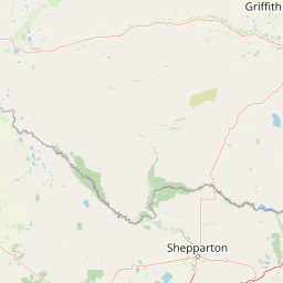
Lower Goulburn National Park landscape and geographic character

The landscape of Lower Goulburn National Park is defined by its linear river corridor, with the Goulburn River serving as the central landscape feature around which the protected area is organized. The river follows a generally meandering course through the park, flanked by banks that support dense stands of river red gum. The riparian zone features trees of varying ages, with mature specimens displaying the characteristic twisted forms and shedding bark typical of old-growth eucalyptus. Between the river and the surrounding farmland, the park preserves a transition zone of woodland and grassy groundcover. The flat to gently undulating terrain reflects the river's low gradient as it approaches its confluence with the Murray. Water pools, shallower riffles, and overhanging vegetation create visual variety along the watercourse, while the canopy of the red gums provides a sense of enclosure and enclosure that distinguishes the river corridor from the more open agricultural lands beyond the park boundaries.

Lower Goulburn National Park ecosystems, habitats, and plant life

The riparian environment of Lower Goulburn National Park supports a characteristic assemblage of plant species adapted to the cyclical patterns of flooding, drought, and seasonal change that define Australian river systems. The dominant river red gum woodland forms a nearly continuous canopy along the protected section, with understory vegetation varying according to proximity to water, soil moisture, and disturbance history. The park's position along a major river corridor means it functions as a wildlife corridor through agricultural land, connecting habitats and allowing animal movement between larger blocks of native vegetation. The river itself supports aquatic ecosystems including fish, invertebrates, and waterfowl. The protected corridor preserves ecological processes such as nutrient cycling, seed dispersal by water and wildlife, and the natural flow patterns that sustain riparian health. Seasonal variations in water levels, leaf litter fall, and flowering periods create temporal diversity in the park's natural character throughout the year.

Lower Goulburn National Park wildlife and species highlights

Lower Goulburn National Park provides habitat for wildlife adapted to riverine environments and woodland habitats in southeastern Australia. Birdlife includes species typical of riparian and woodland habitats, with waterfowl utilizing the river and its pools while smaller birds move through the canopy and understory. The river red gum woodlands shelter arboreal marsupials, and the structural complexity of the forest provides nesting and foraging resources for various species. Fish species inhabiting the Goulburn River include native species adapted to variable flow conditions. The corridor configuration of the park supports wildlife movement through an otherwise cleared agricultural landscape, with the protected river zone serving as a refugium for species that require continuous habitat connectivity. Reptiles and amphibians occupy niches within the riparian zone, utilizing the water, groundcover, and tree hollows that the environment provides.

Lower Goulburn National Park conservation status and protection priorities

The establishment of Lower Goulburn National Park addressed a conservation gap in Victoria's protected area network, preserving riparian values in a region where extensive agricultural development had transformed much of the original landscape. The park protects significant remnants of river red gum woodland, a vegetation type that has been extensively cleared or modified across its former range in southeastern Australia. By preserving a functioning river corridor, the park maintains ecological processes that depend on connectivity between aquatic and terrestrial habitats, including nutrient transfer, wildlife movement, and natural flow regimes. The protected area contributes to broader catchment health by maintaining vegetated banks that filter runoff, stabilize sediments, and provide shade that regulates water temperature. Management focuses on maintaining and enhancing the park's natural values while providing sustainable recreational opportunities compatible with conservation objectives.

Lower Goulburn National Park cultural meaning and human context

The Goulburn River holds significance in the cultural landscape of northern Victoria, with the river corridor having been utilized by Aboriginal peoples for thousands of years prior to European settlement. The lower Goulburn region contains evidence of indigenous occupation and use, with the river providing resources and serving as a travel corridor through the landscape. European settlement of the Goulburn Valley brought agricultural development that progressively altered the river corridor, with clearing for cropping and grazing, water extraction for irrigation, and construction of infrastructure such as weirs and levees. The townships of Shepparton and Echuca, located at either end of the park, reflect the long history of human settlement and use of the Goulburn River system, with Echuca historically serving as a major river port. The establishment of the national park represents a contemporary recognition of the river's natural values alongside its cultural and economic significance.

Top sights and standout views in Lower Goulburn National Park

The river red gum canopy that arches over the Goulburn River forms the most distinctive visual feature of the park, creating a cathedral-like environment along the waterway. The park provides a relatively accessible natural environment in a region where wild places are otherwise scarce, with proximity to Shepparton and Echuca making it a convenient escape for residents and visitors. The linear design of the park, following the river corridor, offers a distinctive exploration experience along the water rather than through interior terrain. The contrast between the natural river corridor and the surrounding productive farmland underscores the conservation value of preserving such habitats within modified landscapes. The park's position near where the Goulburn joins the Murray connects it to one of Australia's most significant river systems, extending the ecological influence of the protected area beyond its boundaries.

Best time to visit Lower Goulburn National Park

The park can be visited throughout the year, though seasonal conditions influence the experience and accessibility. Summer months bring warmer temperatures and lower river levels, offering different conditions for river-based activities and wildlife observation. Winter typically sees higher water flows and cooler conditions, with the landscape displaying different character as seasonal patterns shift. The river red gum canopy provides year-round visual appeal, though autumn may bring color variation as some trees respond to seasonal cues. Visitors interested in birdlife and wildlife observation may find different opportunities across seasons as species activity patterns change. Checking current conditions and park guidelines before visiting helps ensure a safe and enjoyable experience.

Park location guide

Geography guide, regional context, and park location map for Lower Goulburn National Park

Lower Goulburn National Park park geography, regions, and map view in Australia
Understand where Lower Goulburn National Park sits in Australia through a broader geographic reading of the surrounding landscape, nearby location context, and its mapped position within the national park landscape.

How Lower Goulburn National Park fits into Australia

Australia is a constitutional monarchy and federal parliamentary democracy comprising six states and ten territories. With a population of nearly 28 million, it is one of the world's most urbanised countries, with most people concentrated on the eastern seaboard. The country has a high Human Development Index and is known for its cultural diversity, ancient Aboriginal heritage, and unique wildlife.

Wider geography shaping Lower Goulburn National Park in Australia

Australia occupies the entire Australian continent, the island of Tasmania, and numerous smaller islands. It is the world's flattest and driest inhabited continent, featuring vast deserts in the interior (the Outback), tropical rainforests along the eastern coast, and a coastline bordering the Indian and Pacific Oceans.

Map view of Lower Goulburn National Park

Use this park location map to pinpoint Lower Goulburn National Park in Australia, understand its exact geographic position, and read its mapped placement within the surrounding landscape more clearly.

Pigeon | © OpenStreetMap contributors
Park atlas

Explore mapped protected areas and riverine forests across Victoria's Goulburn Valley, extending your atlas view from Lower Goulburn National Park.

Discover Other National Parks Near Lower Goulburn National Park and the Goulburn Valley Region
Browse an organized atlas of national parks and protected areas located geographically near Lower Goulburn National Park in Victoria's Goulburn Valley and the broader Murray-Darling Basin. This curated list allows for direct comparison of diverse riparian protected landscapes, revealing how other riverine forests and significant conservation initiatives connect across the region.
Watercolor illustration of a river landscape with green hills, trees, and pink reeds
National park

Barmah National Park National Park: World's Largest River Red Gum Forest Landscape

Explore Mapped Boundaries and Wetland Geography

Barmah National Park in Victoria, Australia, is renowned for protecting the largest river red gum floodplain forest on Earth, a globally significant Ramsar-listed wetland. This protected area's landscape is defined by majestic eucalypts bordering freshwater marshes along the Murray River. Dive into its distinct geography, mapped terrain, and the protected status of this remarkable ecosystem, offering unparalleled opportunities for understanding regional natural landscapes and conservation.

Area
285.21 km²
Established
2010
IUCN
II
Relief
Lowland
Watercolor painting of green trees, rolling hills, and a pastel sky.
National park

Heathcote-Graytown National Park: Protected Box-Ironbark Forests and Swift Parrot Habitat

Mapping the landscape and geography of this Australian National Park.

Heathcote-Graytown National Park is a significant protected area safeguarding one of Victoria's remaining box-ironbark forest ecosystems. Its landscape, nestled within the Great Dividing Range, provides essential habitat for migratory swift parrots and supports diverse woodland bird species recognized by BirdLife International. Explore the park's mapped terrain and understand its role within the Central Highlands' regional geography as a vital conservation landscape.

Area
128.33 km²
Established
2002
IUCN
II
Relief
Mountain
National park

Terrick Terrick National Park: National Park Geography and Protected Land Exploration

Semi-arid woodland and grassland ecosystems in northern Victoria.

Terrick Terrick National Park represents a crucial protected area showcasing the characteristic Box-Ironbark forest and native grassland ecosystems of northern Victoria. This park is defined by its gently undulating terrain and semi-arid woodland character, offering a distinct natural landscape for geographic study and atlas exploration. Its mapped extent clearly delineates an environment vital for conservation, providing a valuable point of reference for understanding regional protected land distribution and ecological significance within Australia.

Area
38.8 km²
Established
1988
IUCN
II
Relief
Lowland
National park

Greater Bendigo National Park: Essential Protected Landscape and Regional Geography Details

Map exploration of its box-ironbark forest and woodland ecosystems.

Delve into Greater Bendigo National Park, a protected area in Victoria renowned for its extensive box-ironbark forests. This national park is crucial for maintaining the distinct woodland ecosystems that support rich bird populations and provide essential habitat for the endangered swift parrot. Users can explore its mapped geographic extent, understand its landscape character, and appreciate its significance within Australia's protected natural areas.

Area
170 km²
Established
2002
IUCN
II
Relief
Lowland
National park

Warby-Ovens National Park: Protected Landscape and Geographic Atlas Entry

Discover its Box-Ironbark forests and mapped regional terrain.

Warby-Ovens National Park is a protected national park situated in northeastern Victoria, Australia, covering 14,655 hectares of distinctive landscape. It is internationally recognized as an Important Bird Area, primarily for its significant Box-Ironbark forest ecosystem that supports numerous threatened woodland bird species. The park's geography features low granite hills and rolling terrain, with the Ovens River flowing through its northern section. This detail page provides structured information on its protected boundaries, natural landscape characteristics, and its place within regional geography.

Area
146.55 km²
Established
2010
IUCN
II
Relief
Upland
National park

Kinglake National Park: Protected Mountain Ash Forests and Geological Heritage

Explore the mapped landscape and regional geography of this Australian National Park.

Kinglake National Park is a significant protected natural area in Victoria, Australia, distinguished by its mountainous terrain dominated by eucalyptus forests, including towering mountain ash trees. The park's unique geology features sedimentary layers with marine fossils, offering a glimpse into its ancient submerged history. This National Park provides a rich environment for exploring diverse landscapes, understanding fire ecology, and appreciating the mapped boundaries of a resilient natural area.

Area
232.1 km²
Established
1928
IUCN
II
Relief
Upland
Watercolor illustration showing a lake surrounded by green hills and vegetation
National park

Lake Eildon National Park: Protected Landscape with Ancient Volcanic and Gold Mining Heritage

Explore mapped terrain and diverse eucalypt forests.

Lake Eildon National Park in Victoria's Central Highlands offers a unique protected landscape shaped by ancient volcanic activity and the region's gold rush era. This national park, centered around the large Lake Eildon reservoir, provides critical habitat within its diverse eucalypt forests. Discover its geological significance, historical mining sites, and mapped boundaries, offering a comprehensive view of its protected-area identity and regional geographic context.

Area
277.5 km²
Established
1997
IUCN
II
Relief
Mountain
National park

Mount Buffalo National Park: Historic Granite Plateau in Victoria's Alpine Region

Mapped Protected Landscape and Geographic Context

Mount Buffalo National Park represents a significant protected area within Victoria, Australia, celebrated for its distinctive granite plateau. This national park, one of Australia's oldest, features dramatic rock formations, tors, and the iconic summit of The Horn, offering panoramic vistas across the alpine landscape. Its elevation of approximately 1,723 meters supports a variety of ecosystems, from forested slopes to alpine grasslands. The park's unique geology and its role as a protected landscape make it a key destination for understanding regional Australian geography and conservation history.

Area
310 km²
Established
1898
IUCN
II
Visitors
200K annual

Common questions about visiting, size, designation, and location context for Lower Goulburn National Park

Lower Goulburn National Park FAQs for park facts, access, geography, and protected area context
Find quick answers about Lower Goulburn National Park, including protected-area facts, park geography, trail and visitor context, and how the park fits into its surrounding country and regional landscape.
MoriAtlas Explorer

Continue Your Protected Areas Search Across the Global Atlas

Deepen your exploration by continuing the structured search for national parks and protected areas worldwide. Utilize the comprehensive filtering capabilities to compare different conservation landscapes and refine your understanding of global park geography. Discover more about the distribution and characteristics of protected natural areas.

Global natural geography