Mori Atlas logo
National parkMount Walsh National Park

Discover the mapped terrain and unique geology of this Australian National Park.

Mount Walsh National Park: Queensland's Dramatic Granite Protected Landscape

Mount Walsh National Park in Queensland, Australia, presents a striking natural landmark characterized by its prominent 703-meter granite bluff and rugged terrain. This protected area, established in 1947, showcases dramatic exposed cliffs, steep forested ridges, and sheltered gullies shaped by ancient volcanic activity. Its unique geology results in distinct tors, rocky pavements, and boulder-strewn slopes, offering a compelling subject for geographic and landscape exploration. The park's diverse vegetation communities thrive in contrast to the surrounding countryside, highlighting its significance as a mapped protected landscape.

Granite landscapesAustralian national parksQueensland protected areasMountain reservesForest ecosystemsWildlife habitat
Stylized illustration of a mountainous landscape with green fields, scattered trees, and a fence under a partly cloudy sky

Mount Walsh National Park

National park

Park overview

Structured park overview, official facts, and landscape profile for Mount Walsh National Park

Mount Walsh National Park park facts, protected area profile, and essential visitor context
Review the core facts for Mount Walsh National Park, including designation, size, terrain, visitor scale, habitats, and operating context in one park-focused overview.

About Mount Walsh National Park

Mount Walsh National Park occupies a significant place in Queensland's network of protected areas, preserving a representative sample of the region's characteristic granite landscape and associated ecosystems. The park's terrain is dominated by the prominent Mount Walsh formation, a granite uplift that rises dramatically from the surrounding countryside. The northern section of the park contains The Bluff, a rugged area of exposed rock and steep ridges that serves as the park's most recognizable feature. Below the exposed granite summits, the slopes are covered in diverse forest and woodland communities that transition from open eucalypt forest in the lower areas to more sheltered vegetation in the gully systems. The combination of altitude variation, aspect differences, and soil conditions created by granite weathering has produced a mosaic of vegetation types within a relatively compact area. This ecological diversity supports a corresponding variety of wildlife, making the park an important conservation area within the broader regional landscape.

Quick facts and research context for Mount Walsh National Park

Mount Walsh National Park covers 52.40 square kilometers in Queensland, Australia. The park's centerpiece is the granite bluff known as The Bluff, which reaches 703 meters at its summit and features three distinct peaks. The area was protected in 1947 and is managed by the Queensland Parks and Wildlife Service. The geological foundation dates to approximately 215 million years ago, formed by volcanic activity from the Mungore Centre. The park supports diverse vegetation communities ranging from heath and shrubland to woodland, open forest, and dry forest, with hoop pines occurring in sheltered gullies.

Park context

Deeper park guide and search-rich context for Mount Walsh National Park

Mount Walsh National Park history, landscape, wildlife, and travel context
Explore Mount Walsh National Park through its history, landscape character, ecosystems, wildlife, conservation priorities, cultural context, and seasonal travel timing in a structured park guide built for atlas discovery and search intent.

Why Mount Walsh National Park stands out

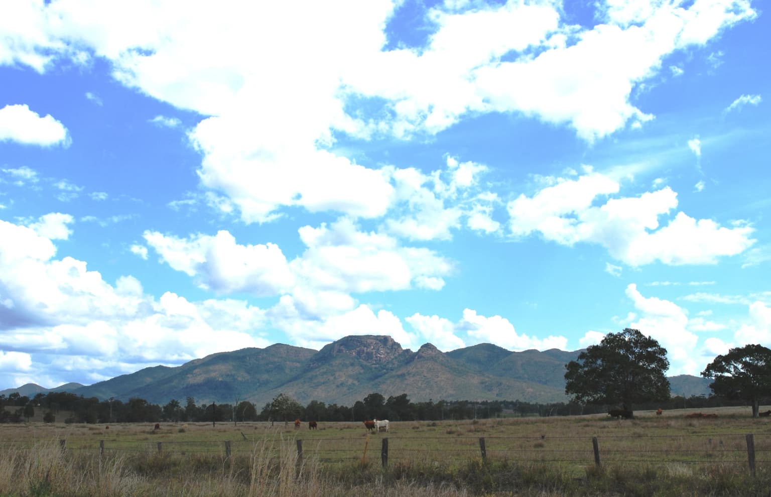
The park is best known for its dramatic granite bluff formation, a striking landmark visible across the Biggenden region. The summit's three-peaked granite dome offers spectacular exposed cliffs and panoramic views from the surrounding countryside. The park's ecological significance lies in the diversity of vegetation communities supported by its complex terrain, which provides habitat for several endangered animal species including the powerful owl and grey goshawk. The contrast between the bare granite summits and the forested slopes below creates a visually distinctive landscape characteristic of this protected area.

Open field with wooden fence posts, scattered trees, and mountains in background under blue sky with white clouds.
Grassy field with wooden fence and distant mountains under partly cloudy sky.

Mount Walsh National Park history and protected-area timeline

Mount Walsh National Park was established in 1947, representing one of Queensland's earlier protected area designations that recognized the scientific and scenic significance of the granite formation. The creation of the park reflected growing awareness in the mid-twentieth century of the need to preserve distinctive landscapes and their associated wildlife. Management of the park was assigned to what is now the Queensland Parks and Wildlife Service, the state agency responsible for managing Queensland's national park estate. The park has maintained its protected status continuously since establishment, surviving various pressures for resource extraction that affected other areas of Queensland. The long-standing protection has allowed the park's ecosystems to remain relatively intact, preserving both the geological features and the biodiversity they support.

Mount Walsh National Park landscape and geographic character

The physical landscape of Mount Walsh National Park is defined by its granite geology, which creates a terrain markedly different from the surrounding pastoral and agricultural land. The central feature is Mount Walsh itself, a dome of exposed granite that rises to 703 meters above sea level. The summit area consists of three peaks separated by rocky cols and cliffs. Below the bare rock summits, the slopes descend steeply through forested terrain, with exposed rock outcrops and cliff bands visible along the ridge lines. The weathering of the granite has produced a distinctive landscape of tors, rocky pavements, and boulder-strewn slopes. In the deeper gullies, the terrain becomes more sheltered and the microclimate supports vegetation types more typical of wetter environments. The contrast between the stark, exposed granite summits and the vegetated slopes below creates a landscape of considerable visual interest and scientific value.

Mount Walsh National Park ecosystems, habitats, and plant life

The ecological character of Mount Walsh National Park reflects the interaction between the park's granite terrain, altitude range, and position within Queensland's bioregional context. The complex topography has produced a diversity of vegetation communities including heath on exposed ridges, shrubland in rocky areas, woodland on the lower slopes, open forest in the more fertile areas, and dry forest in drier aspects. Some gullies contain patches of hoop pine, a distinctive Australian conifer that typically occurs in sheltered rainforest-like settings. The mosaic of vegetation types results from variations in aspect, soil depth, moisture availability, and exposure across the park's terrain. This ecological diversity is significant at both regional and state levels, as the park preserves vegetation communities that have been extensively cleared in the surrounding landscape for agriculture and grazing.

Mount Walsh National Park wildlife and species highlights

The diverse habitats within Mount Walsh National Park support a variety of animal species, including several of conservation significance. The forested slopes and gullies provide important habitat for the powerful owl, one of Australia's largest owl species and listed as endangered in some states. The grey goshawk, a raptor of conservation concern, also occurs in the park's forest habitats. Visitors may encounter peregrine falcons nesting on the cliff faces, while the more open forest areas support populations of eastern grey kangaroos and wallabies. Dingoes, Australia's wild dog, are present in the park and represent an important apex predator in the ecosystem. Lace monitors, a species of large goanna, are commonly seen among the trees and rocky areas. The combination of old-growth forest habitat, rocky nesting sites, and diverse prey populations makes the park particularly valuable for wildlife conservation.

Mount Walsh National Park conservation status and protection priorities

Mount Walsh National Park contributes to Queensland's protected area network by preserving a distinctive granite landscape and its associated biodiversity. The park protects habitat for several species of conservation concern, including the powerful owl and grey goshawk, which depend on forested environments with suitable nesting sites. The preservation of the park's vegetation communities also maintains ecological processes and species populations that have declined across much of the surrounding agricultural landscape. The park's long-term protection since 1947 has allowed ecosystems to remain largely intact, providing a reference area for understanding the region's natural character. The combination of geological significance, habitat diversity, and species protection establishes the park's value within Queensland's conservation estate.

Top sights and standout views in Mount Walsh National Park

The granite summit of Mount Walsh, with its three peaks and exposed rock formations, represents the park's most dramatic feature and a major attraction for visitors. The views from the summit lookouts extend across the surrounding Biggenden region, offering perspectives on the park's distinctive landscape character. The walking trail from the picnic area provides access through changing vegetation, from open eucalypt forest to rainforest-fringed creek gully, before reaching lookouts over the countryside. The park's biodiversity, particularly the presence of powerful owls and grey goshawks, makes it significant for wildlife observation. The contrast between the bare granite peaks and the forested slopes exemplifies the park's distinctive visual identity.

Best time to visit Mount Walsh National Park

The park can be visited throughout the year, with the cooler months typically offering more comfortable conditions for walking and summit hikes. Summer in Queensland brings higher temperatures and increased humidity, particularly in the forest areas, while winter generally provides clearer skies and more comfortable temperatures for outdoor activities. The dry winter and spring months often provide the most stable weather for exploring the park's trails and viewpoints. Visitors planning extended walks or overnight camping should consider seasonal conditions and carry appropriate supplies, as facilities within the park are minimal and self-sufficiency is required.

Park location guide

Geography guide, regional context, and park location map for Mount Walsh National Park

Mount Walsh National Park park geography, regions, and map view in Australia
Understand where Mount Walsh National Park sits in Australia through a broader geographic reading of the surrounding landscape, nearby location context, and its mapped position within the national park landscape.

How Mount Walsh National Park fits into Australia

Australia is a constitutional monarchy and federal parliamentary democracy comprising six states and ten territories. With a population of nearly 28 million, it is one of the world's most urbanised countries, with most people concentrated on the eastern seaboard. The country has a high Human Development Index and is known for its cultural diversity, ancient Aboriginal heritage, and unique wildlife.

Wider geography shaping Mount Walsh National Park in Australia

Australia occupies the entire Australian continent, the island of Tasmania, and numerous smaller islands. It is the world's flattest and driest inhabited continent, featuring vast deserts in the interior (the Outback), tropical rainforests along the eastern coast, and a coastline bordering the Indian and Pacific Oceans.

Map view of Mount Walsh National Park

Use this park location map to pinpoint Mount Walsh National Park in Australia, understand its exact geographic position, and read its mapped placement within the surrounding landscape more clearly.

Pigeon | © OpenStreetMap contributors

Location context for Mount Walsh National Park

Queensland

Detailed Imagery Revealing the Rugged Terrain, Exposed Rock Formations, and Diverse Habitats of this Queensland Protected Area

Mount Walsh National Park Photos: Explore Granite Landscapes, Dramatic Cliffs, and Forest Scenery
Visually explore Mount Walsh National Park's distinctive granite landscapes, dramatic cliffs, and varied forest ecosystems through this curated imagery. Understanding the park's unique scenery, rugged terrain, and diverse habitat types through these photographs enhances geographic discovery and appreciation of its protected environment.

Open field with wooden fence posts, scattered trees, and mountains in background under blue sky with white clouds.

Park atlas

Trace the Regional Park Geography and Protected Landscapes Adjacent to Mount Walsh National Park.

Compare Nearby National Parks and Protected Areas Surrounding Mount Walsh, Queensland
Explore the diverse protected areas and national parks situated within the wider Queensland region, offering varied terrain, distinct ecosystems, and unique conservation landscapes. Continue your geographic discovery beyond Mount Walsh National Park by comparing a curated list of nearby protected areas, mapping their spread, and understanding their individual characteristics in regional context.
National parkQueensland

Coalstoun Lakes National Park: Queensland National Park's Mapped Protected Landscape

Explore regional geography and park boundaries in Queensland.

Coalstoun Lakes National Park is a significant national park entity within Queensland, Australia, offering rich opportunities for geographic discovery. This dedicated page provides detailed insights into its protected landscape, mapped boundaries, and regional context. Understand how Coalstoun Lakes National Park fits within the natural geography of Queensland, supporting structured exploration for users interested in protected areas and map-based insights.

Area
0.26 km²
Established
1929
IUCN
II
Relief
Mixed relief
National parkQueensland

Fairlies Knob National Park: Queensland National Park Protected Landscape Explorer

Mapped protected areas and regional geography in Queensland.

Fairlies Knob National Park offers a unique point of entry into Queensland's atlas of protected areas. This detailed view focuses on the park's identity as a national park, providing insights into its mapped boundaries and its geographical context within the Australian state. Explore the fundamental protected landscape features and understand its place within the broader regional geography.

Area
0.56 km²
Established
1910
IUCN
II
Relief
Lowland
National parkQueensland

Goodnight Scrub National Park: Protected Dry Rainforest and Hoop Pine Ecosystems

Explore the mapped terrain and conservation significance of this Queensland park.

Goodnight Scrub National Park safeguards a rare dry rainforest ecosystem, a significant ecological asset within Queensland's protected area network. Dominated by iconic hoop pine trees, this national park showcases a unique landscape characterized by its distinct vegetation and geographic setting. The park's conservation value is highlighted by its role in preserving a habitat type uncommon in Australia, offering insights into regional landscape dynamics and protected land importance.

Area
63.3 km²
IUCN
II
Relief
Lowland
Access
Moderate access
National parkQueensland

Mount Bauple National Park: Queensland National Park's Protected Landscape and Map Context

Discover its mapped boundaries and regional geography.

Mount Bauple National Park, designated as a national park in Queensland, Australia, offers a unique focus within the state's rich protected area network. This entry provides detailed insight into the park's specific geographic identity and its landscape characteristics. Understanding Mount Bauple National Park is key to grasping the diversity of Queensland's natural terrain and its role in the broader Australian geography. Explore its mapped boundaries and the regional context that defines this significant protected landscape.

Area
5 km²
Established
1935
IUCN
Ia
Relief
Mountain
National parkFraser Coast Region

Poona National Park: Coastal Wetland Refuge and Protected Landscape Exploration

Discover the mapped terrain and regional geography of this national park.

Poona National Park protects a critical coastal wetland ecosystem in Queensland's Fraser Coast Region, renowned for its role as a refuge for endangered trees and threatened animal species. The park's landscape is characterized by extensive marshy areas and coastal forests situated between river systems and the ocean. This undeveloped protected area provides essential habitat, highlighting the unique geographic context and conservation importance of these coastal environments within Australia.

Area
53.68 km²
Established
1991
IUCN
II
Relief
Lowland
National parkAustralia

Burrum Coast National Park: An Atlas View of Australia's Protected Landscape

Explore the mapped terrain and regional geography of this national park.

Burrum Coast National Park in Australia serves as a key node for understanding protected landscapes through a geographic lens. This entry provides detailed context on the park's mapped boundaries and natural terrain, contributing to a structured atlas of Australia's conservation areas. Discover the specific geographic identity and landscape characteristics that define Burrum Coast National Park as a significant protected natural area.

Area
225 km²
Established
1995
IUCN
II
Relief
Lowland
National parkQueensland

Beeron National Park: National Park Protected Landscape in Queensland, Australia

Discover its geographic context and mapped natural terrain.

Delve into Beeron National Park, a distinct national park located in Queensland, Australia. This protected area offers a unique perspective on the region's natural landscapes and geography. By examining its mapped boundaries and its position within Queensland's broader environmental context, users can gain a structured understanding of this significant conservation landscape.

Area
70.5 km²
Established
2009
IUCN
II
Scope
Terrestrial
National parkNorth Burnett Region

Auburn River National Park: A Protected Landscape Defined by River Gorge and Hardwood Forests

Explore the mapped terrain and protected area geography of this Queensland national park.

Auburn River National Park, designated a national park in Australia, showcases a remarkable protected landscape sculpted by the Auburn River. Its geography is characterized by a steep, dramatic river gorge and extensive hardwood forests, creating a visually striking and ecologically significant area. This park provides crucial insight into riparian ecosystems and their role within the regional geographic context of the North Burnett Region, inviting detailed exploration of its mapped terrain and conservation value.

Area
3.9 km²
Established
1964
IUCN
II
Water
Major water bodies

Common questions about visiting, size, designation, and location context for Mount Walsh National Park

Mount Walsh National Park FAQs for park facts, access, geography, and protected area context
Find quick answers about Mount Walsh National Park, including protected-area facts, park geography, trail and visitor context, and how the park fits into its surrounding country and regional landscape.
MoriAtlas Explorer

Continue Your Protected Areas Search Across the Global Atlas

Deepen your exploration by continuing the structured search for national parks and protected areas worldwide. Utilize the comprehensive filtering capabilities to compare different conservation landscapes and refine your understanding of global park geography. Discover more about the distribution and characteristics of protected natural areas.

Global natural geography