Mori Atlas logo
National parkMount Coolum National Park

Discover the unique geology, mapped boundaries, and rich botanical diversity of this Queensland national park.

Mount Coolum National Park: A Distinctive Laccolith Formation in Queensland's Protected Landscape

Mount Coolum National Park stands as a significant protected area within Queensland, renowned for its singular geological identity as a coastal laccolith. This distinctive granite dome rises abruptly from the surrounding plain, offering a unique landscape visible for miles. The park's mapped geography encompasses its dramatic rhyolite cliffs, forested slopes, and pockets of rare vegetation, making it a vital site for understanding regional protected lands and the natural terrain of the Sunshine Coast. Explore its unique features and understand its place in the Queensland atlas.

Coastal mountainsGeological heritageBotanical diversityQueensland national parksLaccolith formationsSunshine Coast

Mount Coolum National Park

National park

Park overview

Structured park overview, official facts, and landscape profile for Mount Coolum National Park

Mount Coolum National Park park facts, protected area profile, and essential visitor context
Review the core facts for Mount Coolum National Park, including designation, size, terrain, visitor scale, habitats, and operating context in one park-focused overview.

About Mount Coolum National Park

Mount Coolum National Park protects a distinctive geological landmark on Queensland's Sunshine Coast, where Mount Coolum rises abruptly from the coastal plain to form a dramatic 208-meter peak. The mountain's laccolith origin—created when a dome-shaped bulge of magma cooled slowly beneath the Earth's surface approximately 26 million years ago—makes it geologically similar to the Glasshouse Mountains to the south but distinct in its isolated coastal setting. The rhyolite that comprises the mountain displays remarkable regular columnar patterns and jointing, visible particularly on the tall eastern and southern cliffs where waterfalls appear after heavy rains. Despite the park's small size of less than one square kilometer, it supports an extraordinary diversity of vegetation communities that transition from coastal wallum and paperbark wetlands at lower elevations through eucalypt forest to rare coastal montane heath and small rainforest pockets near the summit. The walking track ascending the mountain begins from a carpark on Tanah Street West in the Mount Coolum suburb, offering visitors a challenging but rewarding climb to a summit that features an aircraft hazard light due to the mountain's proximity to Sunshine Coast Airport.

Quick facts and research context for Mount Coolum National Park

Mount Coolum National Park occupies 0.69 square kilometers on the Sunshine Coast of Queensland, Australia. The dominant feature is Mount Coolum, a 208-meter laccolith formed from 26-million-year-old rhyolite that creates a distinctive dome-shaped peak with tall cliffs on its eastern and southern faces. The park lies between the Sunshine Motorway to the west and the coastline to the east, adjacent to the townships of Coolum Beach to the north and Marcoola to the south. The area supports more than 700 documented plant species across multiple habitat types including eucalypt forest, coastal wallum, paperbark wetland, montane heath, and small patches of rainforest. The park is crossed by a popular walking track to the summit, with an average of 140 visitors climbing to the peak daily.

Park context

Deeper park guide and search-rich context for Mount Coolum National Park

Mount Coolum National Park history, landscape, wildlife, and travel context
Explore Mount Coolum National Park through its history, landscape character, ecosystems, wildlife, conservation priorities, cultural context, and seasonal travel timing in a structured park guide built for atlas discovery and search intent.

Why Mount Coolum National Park stands out

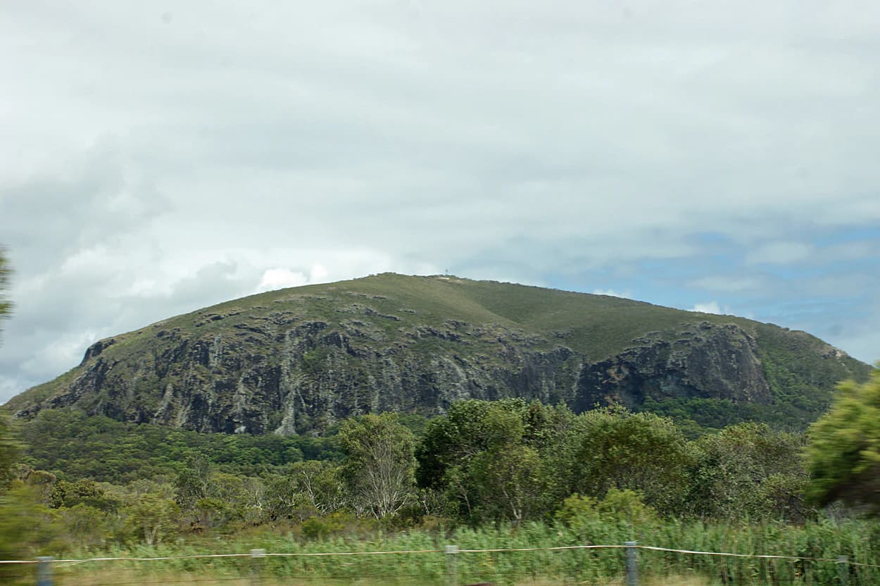
Mount Coolum National Park is best known for its unique geological identity as a coastal laccolith, a rare formation where magma cooled underground to create a distinctive dome-shaped mountain. The mountain's rhyolite cliffs display dramatic columnar jointing patterns, and the peak offers panoramic views across the Sunshine Coast landscape. The park is equally notable for its exceptional botanical diversity, supporting more than 700 plant species within a small footprint, including rare coastal montane heath communities and pockets of subtropical rainforest. The Peregrine falcons that nest on the cliffs add notable wildlife significance to this compact coastal reserve.

A large hill with rocky slopes and green vegetation under a cloudy sky, with trees and grass in the foreground
View of Mount Coolum from the southeast

Mount Coolum National Park history and protected-area timeline

Mount Coolum National Park was formally established in 1990 when the Queensland government protected the mountain and its surrounding slopes as a national park, recognizing both the geological significance of the laccolith formation and the ecological values of the remnant vegetation communities. Prior to protection, the eastern foothills of the mountain contained a quarry operation, the remains of which still occupy a portion of the foothills today. The establishment of the park ended potential further development on the slopes and ensured the preservation of the mountain's character and biodiversity. The walking track to the summit has been maintained to provide public access while managing visitor impact on the sensitive ecological communities, and the installation of an aircraft hazard light on the summit reflects the ongoing balance between recreation and safety considerations given the mountain's proximity to Sunshine Coast Airport.

Mount Coolum National Park landscape and geographic character

The landscape of Mount Coolum National Park is defined by the prominent dome-shaped peak that rises abruptly from the flat coastal plain, creating a striking visual landmark visible across much of the northern Sunshine Coast. The laccolith formation results in a roughly circular mountain with steep to vertical cliffs on the eastern and southern sides, contrasting with more gradual slopes on other aspects. The rhyolite geology produces distinctive columnar structures visible in the cliff faces, and the weathering of the rock creates interesting jointing patterns throughout the exposed rock. A disused quarry occupies the lower eastern foothills, marking human modification of the landscape prior to national park establishment. After periods of rainfall, temporary waterfalls cascade down the cliff faces, adding dynamic water features to the otherwise dry granite landscape. The vegetation cloaks the lower slopes in varying density, with the forest and heath communities creating a green backdrop that frames the grey granite dome.

Mount Coolum National Park ecosystems, habitats, and plant life

The nature of Mount Coolum National Park is characterized by remarkable botanical diversity concentrated within a small area, with more than 700 plant species documented within the park boundaries. The vegetation communities transition across the elevation gradient, starting with coastal wallum-heath communities on the lower slopes and transitioning through eucalypt forest to reach rare coastal montane heath and small patches of subtropical rainforest near the summit. The paperbark wetlands in the lower areas provide contrast to the drier forest and heath communities, creating a mosaic of habitat types that supports the high species count. The coastal setting influences the plant communities, with salt-tolerant species and coastal species interacting with montane elements that find their northernmost expression in this location. The diversity of habitats within such a small area makes the park botanically significant at both regional and national scales.

Mount Coolum National Park wildlife and species highlights

While the Wikipedia source provides limited specific wildlife detail, Mount Coolum National Park supports notable bird species including peregrine falcons that are reported to nest on the cliffs of the mountain. The diverse vegetation communities provide habitat for various bird species, and the cliff faces offer nesting sites for raptors. The varied habitat types from wetlands through forest to heath support different wildlife assemblages, though detailed species inventories are not extensively documented in available sources. The proximity to the coast also means marine and coastal bird species may be observable from the summit viewpoints.

Mount Coolum National Park conservation status and protection priorities

Mount Coolum National Park serves as an important conservation reserve despite its small size, protecting a rare laccolith formation and exceptional botanical diversity on Australia's heavily developed Sunshine Coast. The park preserves multiple vegetation types that have been largely cleared from surrounding areas, including remnants of coastal wallum, eucalypt forest, and the particularly rare coastal montane heath community that occurs on the mountain slopes. The more than 700 plant species documented within the park represent significant biodiversity value, particularly in the context of the urbanized Sunshine Coast region where much of the original vegetation has been removed for development. Protection of the mountain also preserves geological features of scientific and educational interest, including the columnar jointing in the rhyolite and evidence of the laccolith formation process.

Mount Coolum National Park cultural meaning and human context

The Mount Coolum area holds significance as a local landmark and visual identity for the surrounding community, with the suburb of Mount Coolum taking its name from the mountain itself. The traditional Aboriginal context of the area is not extensively documented in the available source material, though the broader Sunshine Coast region contains areas of Indigenous cultural heritage. The mountain's prominence as a visual landmark and recreational destination has shaped the local landscape character and community identity, with the national park status ensuring the mountain's preservation as a natural asset for future generations.

Top sights and standout views in Mount Coolum National Park

The standout features of Mount Coolum National Park include the unique laccolith formation visible as a dramatic granite dome rising from the coastal plain, the challenging summit walk offering panoramic views across the Sunshine Coast, the exceptional botanical diversity with more than 700 plant species across varied habitats, and the rare coastal montane heath communities that occur on the mountain slopes. The columnar jointing in the rhyolite cliffs, the seasonal waterfalls after heavy rain, and the peregrine falcon nesting sites add additional notable elements to this compact coastal reserve.

Best time to visit Mount Coolum National Park

Mount Coolum National Park can be visited year-round, though the cooler winter months from May through September typically offer more comfortable conditions for climbing. The track becomes dangerously slippery when wet, so visitors should avoid starting the climb during or after rainfall, and the steep rough terrain means the walk should not be attempted in late afternoon when dusk could pose a safety risk. Summer months may be hot and humid, while storm activity in the warmer months can create hazardous conditions on the exposed summit. The best conditions for climbing are typically clear, dry days when the track is safe and the visibility from the summit provides the full benefit of the panoramic views.

Park location guide

Geography guide, regional context, and park location map for Mount Coolum National Park

Mount Coolum National Park park geography, regions, and map view in Australia
Understand where Mount Coolum National Park sits in Australia through a broader geographic reading of the surrounding landscape, nearby location context, and its mapped position within the national park landscape.

How Mount Coolum National Park fits into Australia

Australia is a constitutional monarchy and federal parliamentary democracy comprising six states and ten territories. With a population of nearly 28 million, it is one of the world's most urbanised countries, with most people concentrated on the eastern seaboard. The country has a high Human Development Index and is known for its cultural diversity, ancient Aboriginal heritage, and unique wildlife.

Wider geography shaping Mount Coolum National Park in Australia

Australia occupies the entire Australian continent, the island of Tasmania, and numerous smaller islands. It is the world's flattest and driest inhabited continent, featuring vast deserts in the interior (the Outback), tropical rainforests along the eastern coast, and a coastline bordering the Indian and Pacific Oceans.

Map view of Mount Coolum National Park

Use this park location map to pinpoint Mount Coolum National Park in Australia, understand its exact geographic position, and read its mapped placement within the surrounding landscape more clearly.

Pigeon | © OpenStreetMap contributors

Location context for Mount Coolum National Park

Queensland

Visual Atlas of Mount Coolum's Distinctive Laccolith Formation, Protected Habitats, and Panoramic Coastal Views

Mount Coolum National Park Photos: Explore Unique Coastal Mountain Landscapes and Scenery
Visually explore Mount Coolum National Park, examining its unique laccolith formation, dramatic granite dome, and the diverse landscapes of Queensland's Sunshine Coast. These images provide essential insight into the park's protected habitats, including rhyolite cliffs and rare coastal montane heath, clarifying its distinct ecological and geological character.

A large hill with rocky slopes and green vegetation under a cloudy sky, with trees and grass in the foreground

Park atlas

Map the diverse protected areas and unique geological formations throughout Queensland's Sunshine Coast region.

Explore Nearby National Parks and Protected Areas Around Mount Coolum National Park
After exploring Mount Coolum National Park, discover other national parks and protected areas across Queensland's Sunshine Coast. Compare diverse park geography and trace connected protected landscapes, examining distinct geological heritage and ecological values across the surrounding Queensland region.
National parkQueensland

Ferntree Creek National Park: Queensland National Park Protected Landscape and Map Context

Discover mapped boundaries and regional geography within Queensland.

Ferntree Creek National Park, identified as a national park within Queensland, Australia, offers a specific point of reference for protected landscape exploration. This detail page provides geographic context, mapping its protected area boundaries and situating it within the regional atlas. Understand the landscape and its place in Queensland's natural geography through structured data and map-based discovery.

Area
0.72 km²
Established
1947
IUCN
II
Relief
Lowland
National parkQueensland

Eudlo Creek National Park: Queensland National Park Protected Landscape

Mapped geography and protected area context.

Eudlo Creek National Park is a designated national park situated within the vast geographical expanse of Queensland, Australia. This entry facilitates an atlas-style understanding of the park, highlighting its mapped boundaries and its significance as a protected natural landscape. Delve into the regional geography and landscape context to appreciate Eudlo Creek National Park's role within Australia's network of conservation areas.

Area
0.43 km²
Established
1951
IUCN
II
Climate
Subtropical
National parkQueensland

Noosa National Park: Queensland's Protected Landscape and Geographic Context

Mapped boundaries and natural terrain of Noosa National Park.

Gain insight into Noosa National Park, a designated national park in Queensland. This detailed view focuses on its protected landscape identity, mapped geographic spread, and role within the regional atlas. Understand the terrain and park boundaries to deepen your exploration of Australia's protected natural areas.

Area
28.83 km²
Established
1939
IUCN
II
Visitors
2M annual
National parkQueensland

Triunia National Park: Mapped Protected Landscape within Queensland's Geography

Explore Queensland's natural terrain and park boundaries.

Triunia National Park stands as a protected landscape offering a distinct point for geographic exploration within Queensland, Australia. This page details the park's specific mapped boundaries and its contribution to the state's rich natural terrain, providing essential context for atlas-based discovery. Users can delve into the regional geography surrounding Triunia National Park, enhancing their understanding of Australia's protected areas and diverse ecosystems.

Area
0.18 km²
Established
1994
IUCN
II
Access
Access unknown
National parkQueensland

Tewantin National Park: Queensland National Park with Volcanic Peaks and Coastal Rainforest

Explore its unique ecosystems and protected landscape boundaries.

Tewantin National Park is a key protected area in Queensland, recognized for its distinct landscape blending coastal rainforest, vibrant Wallum Heath, and the ancient volcanic dome of Mount Tinbeerwah. This national park provides essential conservation for endangered species, particularly amphibians and the swamp stringybark tree, serving as an important natural enclave within the Sunshine Coast region. Its mapped geography offers insight into the ecological significance of this protected landscape, contributing a vital piece to Australia's atlas of natural heritage.

Area
13 km²
IUCN
II
Relief
Mixed relief
Climate
Subtropical
Watercolor painting showing a lake, mountains, trees, and flowers
National parkQueensland

Kondalilla National Park: Protected Waterfall Landscape and Bunya Pine Atlas

Explore Queensland's Blackall Range geography and mapped natural terrain.

Kondalilla National Park is a protected national park on the Blackall Range in Queensland, recognized for its significant remnant subtropical rainforest and spectacular waterfalls. This atlas entry provides detailed insight into its mapped boundaries, geographic setting, and the unique landscape character, including the easternmost bunya pine stands, making it a key destination for protected-area discovery.

Area
3.27 km²
Established
1945
IUCN
II
Relief
Mixed relief
National parkQueensland

Mapleton Falls National Park: National Park Geography and Protected Landscape Identity in Queensland

Explore mapped boundaries and regional natural terrain.

Mapleton Falls National Park is a protected natural area within Queensland, Australia, designated as a national park. This entry provides a focused atlas-style exploration of its geographic features, mapped protected boundaries, and its significance as part of Queensland's broader natural landscape. Discover the park's specific terrain and its place within the regional geography for detailed landscape context.

Area
0.26 km²
Established
1973
IUCN
II
Scope
Terrestrial
National parkQueensland

Dularcha National Park: Queensland National Park Landscape and Geographic Context

Explore mapped protected areas and natural terrain.

Delve into the specific protected landscape of Dularcha National Park, a national park situated in Queensland, Australia. This entry provides detailed information on its geographic features and mapped boundaries, contributing to a structured understanding of protected areas within the Australian atlas. Examine Dularcha National Park's unique natural environment and its place within the Sunshine State's diverse terrain.

Area
4.64 km²
Established
1921
IUCN
II
Climate
Subtropical

Common questions about visiting, size, designation, and location context for Mount Coolum National Park

Mount Coolum National Park FAQs for park facts, access, geography, and protected area context
Find quick answers about Mount Coolum National Park, including protected-area facts, park geography, trail and visitor context, and how the park fits into its surrounding country and regional landscape.
MoriAtlas Explorer

Continue Your Protected Areas Search Across the Global Atlas

Deepen your exploration by continuing the structured search for national parks and protected areas worldwide. Utilize the comprehensive filtering capabilities to compare different conservation landscapes and refine your understanding of global park geography. Discover more about the distribution and characteristics of protected natural areas.

Global natural geography