Mori Atlas logo
National parkMutawintji National Park

Discover mapped boundaries and arid terrain of this significant Australian national park.

Mutawintji National Park: New South Wales Protected Landscape and Indigenous Heritage

Mutawintji National Park stands as a vital protected area within New South Wales, Australia, offering a unique lens into the continent's outback wilderness and rich Aboriginal heritage. This page serves as a gateway to understanding the park's distinct geographic features, including the rugged Byngnano Range, colourful gorges, and vital creek systems. Explore the mapped landscape and discover the extraordinary cultural significance of its ancient rock art galleries and conservation successes.

Aboriginal heritageRock artOutback wildernessNational parkSemi-arid landscapeIndigenous managed

Mutawintji National Park

National park

Park overview

Structured park overview, official facts, and landscape profile for Mutawintji National Park

Mutawintji National Park park facts, protected area profile, and essential visitor context
Review the core facts for Mutawintji National Park, including designation, size, terrain, visitor scale, habitats, and operating context in one park-focused overview.

About Mutawintji National Park

Mutawintji National Park occupies a dramatic landscape in the semi-arid far west of New South Wales, where the rugged Byngnano Range rises from the surrounding plains with its characteristic mulga woodland covering the ridges and slopes. Deep colourful gorges cut through the range, exposing ancient rock formations and creating pockets of concentrated biodiversity along the creek beds lined with river red gums. The park's cultural significance is profound, with the Mutawintji Historic Site protecting some of the most important Aboriginal rock art in the country. The rock art occurs throughout the park in caves and overhangs, representing a continuous cultural tradition spanning millennia. In 1998, a landmark agreement transferred three protected sites to the Mutawintji Local Aboriginal Land Council, representing the first arrangement of its kind in New South Wales, with the land then leased back to NSW National Parks for collaborative management with the Mutawintji Board of Management. This partnership model has become a reference point for Indigenous land management arrangements across Australia.

Quick facts and research context for Mutawintji National Park

Mutawintji National Park spans 689 square kilometres in the semi-arid far west of New South Wales, characterized by the mulga-clad Byngnano Range dissected by spectacular gorges and rocky creek systems. The park protects Mutawintji Historic Site, renowned for its extensive Aboriginal rock art galleries featuring both paintings and engravings. It serves as critical habitat for the yellow-footed rock wallaby, with dedicated conservation fencing in the Coturaundee Ranges having secured the last remaining population in New South Wales. The park is managed collaboratively through a lease arrangement between the Mutawintji Local Aboriginal Land Council and NSW National Parks and Wildlife Service.

Park context

Deeper park guide and search-rich context for Mutawintji National Park

Mutawintji National Park history, landscape, wildlife, and travel context
Explore Mutawintji National Park through its history, landscape character, ecosystems, wildlife, conservation priorities, cultural context, and seasonal travel timing in a structured park guide built for atlas discovery and search intent.

Why Mutawintji National Park stands out

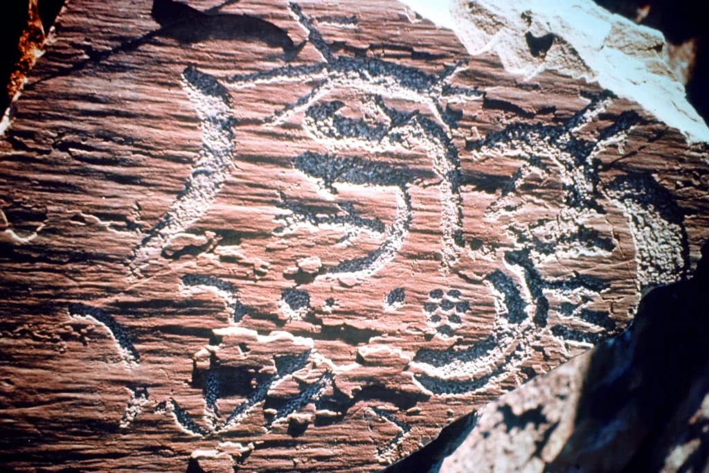
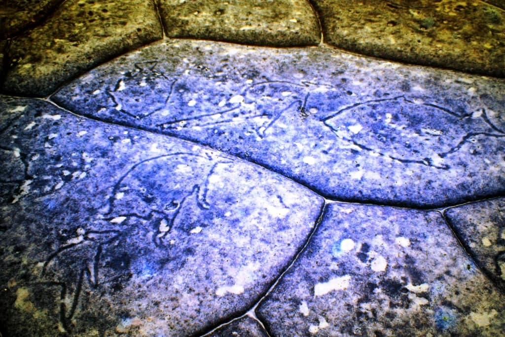
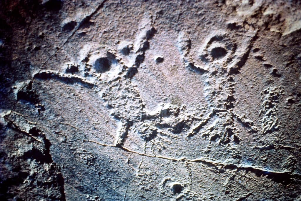
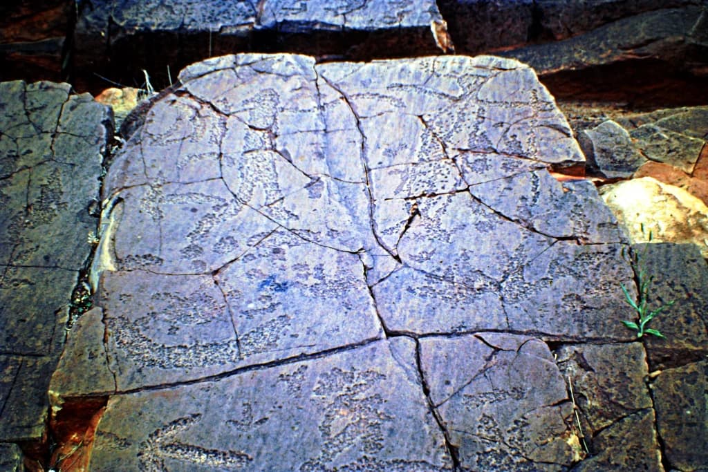
Mutawintji National Park is best known for its extraordinary Aboriginal rock art heritage, with galleries containing both painted and engraved works found throughout the caves and sandstone overhangs of the Byngnano Range. The park protects one of the most significant collections of Indigenous rock art in Australia, depicting animals, figures, and ancestral beings in a landscape that has been central to Aboriginal culture for thousands of years. The park is also notable for its successful conservation of the yellow-footed rock wallaby, which was saved from near-extinction in New South Wales through dedicated fencing and fox control programs in the Coturaundee Ranges.

Mutawintji Waterhole
A waterhole at Mutawintji National Park (formerly Mootwingee National Park).

Mutawintji National Park history and protected-area timeline

Mutawintji National Park was formally established on 4 September 1998, marking the culmination of years of negotiation between the NSW Government and Aboriginal stakeholders. Prior to establishment, the area existed under different designations including Mootwingee National Park. The 1998 establishment was accompanied by a groundbreaking agreement that transferred Mutawintji National Park, Mutawintji Historic Site, and Mutawintji Nature Reserve to the Mutawintji Local Aboriginal Land Council, holding the land on behalf of the Malyangapa, Wilyakali, Wanyuparlku, and Pantjikali peoples. The three sites were then leased back to NSW National Parks and Wildlife Service, creating a collaborative management framework through the Mutawintji Board of Management. This agreement was the first of its kind in New South Wales and represented a significant shift in protected area management toward acknowledging Aboriginal people's ongoing connection to Country. The park's history as a protected area follows decades of recognition of its exceptional cultural and natural values, with the rock art galleries having attracted scholarly and public attention since the mid-twentieth century.

Mutawintji National Park landscape and geographic character

The landscape of Mutawintji National Park is defined by the Byngnano Range, a series of rugged sandstone ridges and peaks that rise abruptly from the surrounding semi-arid plains. The range is cloaked in mulga woodland, a characteristic vegetation of Australia's arid interior, while the creek beds and drainage lines support river red gum forests that provide verdant contrast to the otherwise dun-coloured terrain. Colourful gorges dissect the range, their walls displaying layered sedimentary formations in shades of red, orange, and cream. Rockpools and permanent waterholes occur in the creek systems, providing critical water sources for wildlife during the hot summer months. The Coturaundee Ranges form a western section of the park, offering additional ridgeline and gorge terrain. The overall visual character combines the classic Australian outback aesthetic with more intimate, lush riparian corridors along the creek systems.

Mutawintji National Park etched stone emu art
Etched stone emu rock art at Mutawintji National Park, 1976.

Mutawintji National Park ecosystems, habitats, and plant life

The nature of Mutawintji reflects the semi-arid conditions of far west New South Wales, where rainfall is infrequent and temperatures range from extreme heat in summer to cool nights in winter. The mulga woodlands across the ridges support a range of adapted species, while the riparian zones along creeks provide more lush habitats. The park's most notable conservation achievement is the protection of the yellow-footed rock wallaby, which was on the brink of extinction in New South Wales prior to conservation interventions. In 1979, the Foundation for National Parks & Wildlife purchased and fenced 100 square kilometres in what is now the Coturaundee Ranges, enabling a successful fox eradication program that allowed the population to recover. The park supports a diversity of birdlife adapted to the arid environment, including wedge-tailed eagles soaring on thermal currents, peregrine falcons hunting from cliff perches, and flocks of budgerigars and zebra finches that move through the mulga in search of seeds.

Mootwingie rock art, Mutawintji National Park
Photograph taken in 1976 during a driving trip through far west New South Wales.

Mutawintji National Park wildlife and species highlights

Mutawintji National Park supports a range of wildlife adapted to the semi-arid outback environment, with the yellow-footed rock wallaby standing as the park's most significant faunal resident. These distinctive marsupials inhabit the rocky outcrops and gorges throughout the park, their agility allowing them to navigate the steep terrain with ease. The 1979 conservation program that fenced 100 square kilometres in the Coturaundee Ranges proved decisive in saving the last remaining population of yellow-footed rock wallabies in New South Wales. Birdlife is diverse and conspicuous, with wedge-tailed eagles regularly spotted riding thermals above the ridges, peregrinefalcons nesting on cliff faces, and flocks of budgerigars and zebra finches moving through the woodland. Other species include little corellas, apostle birds, and magpies, with the creek systems providing habitat for various waterbirds during periods when water is available.

Mootwingee waterhole
Waterhole at Mootwingee National Park.

Mutawintji National Park conservation status and protection priorities

Mutawintji National Park represents significant conservation value in Australia's semi-arid interior, combining cultural heritage protection with natural ecosystem preservation. The park's conservation significance is magnified by its role as habitat for the yellow-footed rock wallaby, a species that was facing extinction in New South Wales before the dedicated conservation program in the Coturaundee Ranges. The 100-square-kilometre fenced area established in 1979, combined with ongoing fox control, has enabled this population to persist and recover. The protection of the mulga woodland ecosystems, creek systems, and gorge habitats maintains ecological processes in a landscape that faces pressures from introduced species, climate variability, and development pressures. The collaborative management model, with the Mutawintji Local Aboriginal Land Council holding the land on behalf of Traditional Owners, represents an important conservation approach that integrates Indigenous knowledge and ongoing connection to Country.

Mutawintji National Park cultural meaning and human context

Mutawintji holds profound cultural significance for the Malyangapa, Wilyakali, Wanyuparlku, and Pantjikali peoples, whose connection to this Country extends back tens of thousands of years. The park protects exceptional Aboriginal cultural heritage, most notably through the extensive rock art galleries of Mutawintji Historic Site, where both paintings and engravings depicting ancestral beings, animals, and ceremonial content are found throughout caves and overhangs. This rock art represents a living cultural tradition, with the landscape holding deep spiritual meaning for Aboriginal people. The 1998 management agreement was groundbreaking in acknowledging these ongoing connections, transferring the protected areas to the Mutawintji Local Aboriginal Land Council before lease arrangements saw NSW National Parks resume management under collaborative arrangements. This model was the first of its kind in New South Wales and has informed subsequent Indigenous land management agreements across the state and territory.

Hand stencils, Mootwingee, 1976
Hand stencils at Mootwingee National Park, 1976.

Top sights and standout views in Mutawintji National Park

The spectacular Byngnano Range with its colourful gorges and sandstone cliffs offers outstanding landscape appeal, particularly along creek systems lined with river red gums. The rock art galleries found throughout the caves and overhangs represent one of Australia's most important collections of Indigenous art, with both painted and engraved works demonstrating extraordinary artistic and cultural heritage. The successful recovery of the yellow-footed rock wallaby through the Coturaundee conservation program stands as a notable achievement in Australian wildlife conservation. The collaborative management arrangement with the Mutawintji Local Aboriginal Land Council and the Mutawintji Board of Management represents an innovative approach to protected area governance that integrates Aboriginal values and knowledge.

Hand stencil in rock overhang, Mootwingi
A hand stencil is depicted within a rock overhang at Mootwingi.

Best time to visit Mutawintji National Park

Mutawintji National Park can be visited throughout the year, though the cooler months from autumn through to spring offer the most comfortable conditions for exploring the landscape. Winter months (June to August) bring mild daytime temperatures ideal for bushwalking and sightseeing, though nights can be cold. Spring (September to November) brings pleasant weather and the possibility of seeing wildflowers in bloom across the mulga woodland. Summer (December to February) brings extreme heat in the outback, with temperatures regularly exceeding 40 degrees Celsius, making midday outdoor activity uncomfortable and potentially dangerous. The park's semi-arid climate means rainfall can occur at any time of year, though it is typically infrequent.

Park location guide

Geography guide, regional context, and park location map for Mutawintji National Park

Mutawintji National Park park geography, regions, and map view in Australia
Understand where Mutawintji National Park sits in Australia through a broader geographic reading of the surrounding landscape, nearby location context, and its mapped position within the national park landscape.

How Mutawintji National Park fits into Australia

Australia is a constitutional monarchy and federal parliamentary democracy comprising six states and ten territories. With a population of nearly 28 million, it is one of the world's most urbanised countries, with most people concentrated on the eastern seaboard. The country has a high Human Development Index and is known for its cultural diversity, ancient Aboriginal heritage, and unique wildlife.

Wider geography shaping Mutawintji National Park in Australia

Australia occupies the entire Australian continent, the island of Tasmania, and numerous smaller islands. It is the world's flattest and driest inhabited continent, featuring vast deserts in the interior (the Outback), tropical rainforests along the eastern coast, and a coastline bordering the Indian and Pacific Oceans.

Map view of Mutawintji National Park

Use this park location map to pinpoint Mutawintji National Park in Australia, understand its exact geographic position, and read its mapped placement within the surrounding landscape more clearly.

Pigeon | © OpenStreetMap contributors

Location context for Mutawintji National Park

Far WestNew South Wales

Gain visual insight into Mutawintji National Park's rugged Byngnano Range, vibrant gorges, and significant Aboriginal cultural landscapes.

Mutawintji National Park Photos: Visualizing Outback Landscapes and Cultural Heritage
The gallery provides a visual understanding of Mutawintji National Park's distinctive outback terrain, including the dramatic Byngnano Range, colourful gorges, and vital creek systems. These images help reveal the park's unique protected-area character, its diverse habitats, and the profound significance of its Aboriginal cultural landscapes.

Mutawintji Waterhole

Mootwingee Rock Etchings

Mutawintji National Park etched stone emu art

Mootwingie rock art, Mutawintji National Park

Mootwingee waterhole

Kangaroos etched on rocks

Hand stencils, Mootwingee, 1976

Hand stencil in rock overhang, Mootwingi

Ancient rock etchings, Mutawintji

Etched human-like figures, Mootwingee

Etched rock figures

Park atlas

Map the geographic spread of protected landscapes, comparing outback wilderness and cultural sites across New South Wales.

Explore Other National Parks and Protected Areas Near Mutawintji National Park
Browse other national parks and protected areas near Mutawintji National Park to continue your geographic discovery of Australia's diverse outback landscapes. Compare their unique conservation profiles, regional terrain features, and cultural significance to trace wider protected-area patterns across New South Wales and beyond.
National parkNew South Wales

Kinchega National Park: National Park Protected Area in New South Wales

Explore the mapped Darling River terrain and outback landscapes.

Kinchega National Park stands as a protected national park entity within New South Wales, Australia. Its geographic significance is deeply tied to the Darling River, which shapes its unique riparian ecosystems and contrasts with the surrounding semi-arid outback terrain. This park offers a valuable point for atlas-based discovery, allowing exploration of its mapped boundaries, landscape context, and the conservation of its distinct natural and cultural heritage within the regional geography.

Area
442.59 km²
Established
1967
IUCN
II
National parkNew South Wales

Toorale National Park: Inland Floodplain and Wetland Protected Area in New South Wales

Discover its unique geography at the Darling and Warrego River confluence.

Toorale National Park is a critical protected area in the arid interior of New South Wales, Australia, recognized for its expansive inland floodplain and a significant wetland system formed by historic water management. Situated at the convergence of the Darling and Warrego Rivers, the park's terrain is predominantly flat, characterized by riparian floodplains and occasional low ridges. This landscape supports diverse vegetation communities, including river red gum forests and extensive chenopod shrublands, offering a unique insight into inland Australian geography and conservation values. Explore the mapped boundaries and natural context of this important national park.

Area
308.66 km²
Established
2010
IUCN
II
National parkQueensland

Currawinya National Park: Queensland's Ramsar Wetland and Mulga Lands National Park

Discover its arid landscape and protected area identity.

Currawinya National Park is a major protected area in Queensland, Australia, recognized for its significant Ramsar-listed wetland system, including Lakes Numalla and Wyara. These ephemeral lakes are vital drought refuges for waterbirds across inland Australia and represent a unique ecological feature within the park's expansive mulga lands landscape. The park also champions conservation initiatives, notably a large predator-exclusion enclosure for the greater bilby, showcasing its commitment to arid-zone biodiversity and landscape preservation.

Area
1,513 km²
Established
1991
IUCN
II
National parkQueensland

Lake Bindegolly National Park: A Mapped Protected Wetland Sanctuary in Queensland

Discover its rare flora and vital bird habitat in the Mulga Lands.

Lake Bindegolly National Park is a significant protected natural area situated in the Mulga Lands of Queensland, Australia. This national park preserves a unique three-lake system, essential for rare plant conservation and recognized internationally as an Important Bird Area. The transient wetlands within the park attract a remarkable diversity of bird species, especially waterfowl, making it a key destination for understanding inland Australian geography and the importance of protected landscapes.

Area
140 km²
Established
1991
IUCN
II
Relief
Lowland
National parkSouth Australia

Murray River National Park: Protected Wetland Ecosystems in South Australia

Explore South Australia's unique river red gum floodplains.

Murray River National Park is a significant protected area in South Australia, renowned for its expansive wetland and floodplain environments situated along the Murray River. This national park preserves crucial habitats within the Murray-Darling Basin, characterized by river red gum woodlands, permanent water bodies, and dynamic seasonal floodplains. Its detailed maps and geographic context offer deep insights into one of Australia's most important riverine conservation landscapes.

Area
148.79 km²
Established
1991
IUCN
VI
National parkVictoria

Murray-Sunset National Park: Victoria's Iconic Pink Lakes and Mallee Woodland Protected Landscape

Explore the mapped geography and semi-arid wilderness of this significant Australian protected area.

Murray-Sunset National Park represents a significant portion of Victoria's semi-arid natural heritage, renowned for its striking Pink Lakes that bloom with vibrant color in late summer. This protected landscape encompasses vast mallee woodlands, ancient sand dunes, and extensive salt pans, offering a unique geographic context for atlas exploration. Discover the rich birdlife and distinctive terrain that make this large national park a crucial element of Australia's protected areas network.

Area
6,330 km²
Established
1991
IUCN
II
National parkSouth Australia

Lake Torrens National Park: Explore South Australia's Remarkable Inland Salt Lake Geography

A unique protected landscape of arid plains and expansive salt flats.

Lake Torrens National Park offers an unparalleled exploration of Australia's remote outback, centered around a vast, ancient salt lake basin. This national park in South Australia provides a canvas of stark, minimalist terrain, featuring shimmering saltpans, arid gibber plains, and rocky outcrops. Understand the park's unique geographic identity, its ecological significance as a temporary wetland habitat, and its dramatic visual appeal for landscape photography and geological interest. It is a key protected area showcasing the extreme environment of Australia's interior.

Area
5,676.68 km²
Established
1991
IUCN
VI
National parkRiverina

Cocoparra National Park: Semi-Arid Hill Country and Protected Landscape in Riverina

Explore mapped geography and key natural features of this Australian national park.

Cocoparra National Park is an essential protected natural area within Australia's Riverina region, noted for its striking semi-arid landscape. The park features a prominent range of low hills, including Bingar Mountain, rising from the predominantly flat terrain. This distinctive geography, characterized by rocky sandstone ridges and characteristic woodland communities, offers valuable insights into the region's natural heritage. As an Important Bird Area, Cocoparra National Park also holds significant conservation value for its avian populations and their unique inland habitat.

Area
83.57 km²
Established
1969
IUCN
II

Common questions about visiting, size, designation, and location context for Mutawintji National Park

Mutawintji National Park FAQs for park facts, access, geography, and protected area context
Find quick answers about Mutawintji National Park, including protected-area facts, park geography, trail and visitor context, and how the park fits into its surrounding country and regional landscape.
MoriAtlas Explorer

Continue Your Protected Areas Search Across the Global Atlas

Deepen your exploration by continuing the structured search for national parks and protected areas worldwide. Utilize the comprehensive filtering capabilities to compare different conservation landscapes and refine your understanding of global park geography. Discover more about the distribution and characteristics of protected natural areas.

Global natural geography